
Geography of Poland
Lake Śniardwy, 113.4 km2 (43.8 sq mi) | |
| Climate | temperate climate |
|---|---|
| Terrain | swamps, level terrain, hills, mountains |
| Natural resources | coal, sulfur, copper, silver, natural gas, iron, zinc, lead, salt, arable land |
| Exclusive economic zone | 30,533 km2 (11,789 sq mi) |
| Maps of Poland | |
|---|---|
| Topography | |
| Major agglomerations | |

Tatra Sudetes Interactive map with links to articles | |
| Provinces and highways | |
 | |
| Satellite photo by NASA Landsat 7 | |
 | |
| Hypsometry | |
 | |
| Satellite photo, winter 2003 | |
 Snow cover in mid-winter |
Geographically, Poland is a diverse country; although most of the central terrain is flat, there is an abundance of lakes, rivers, hills, swamps, beaches, islands and forests elsewhere. The Baltic coast has two natural
The country's longest and most prominent river is the
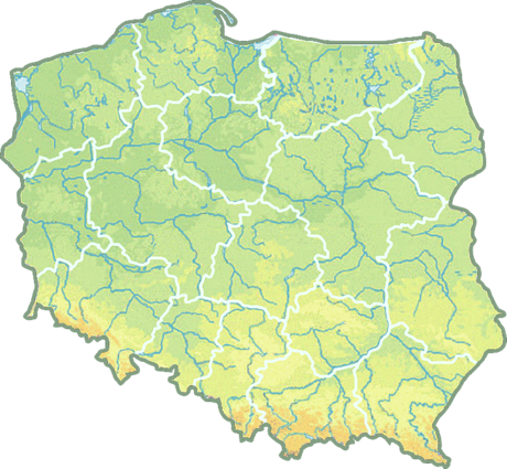
Topography
The country extends 649 kilometers from north to south and 689 kilometers from east to west. The total area is 311,888 square kilometres (120,421 sq mi), including inland waters.[9] The average elevation is 173 metres (568 ft); around 25% of Polish territory is above this average elevation and 3% lies above 500 metres (1,600 ft).[10] The country's highest peak is Rysy, which rises 2,501 meters in the Tatra Range of the Carpathian Mountains, 95 kilometers south of Kraków. Poland has an exclusive economic zone of 30,533 square kilometres (11,789 sq mi) within the Baltic Sea.[11]
Topographic regions
Poland is traditionally divided into five topographic zones from north to south.
The largest, the central lowlands or "Polish Plain" (
To the south of the lowlands are the lesser Poland uplands, a belt varying in width from 90 to 200
The third topographic area is located on either side of Poland's southern border and is formed by the Sudeten and Carpathian ranges. Within Poland, neither of these ranges is forbidding enough to prevent substantial habitation; the Carpathians are not densely populated. The rugged form of the Sudeten range derives from the geological shifts that formed the later Carpathian uplift. The highest elevation in the Sudeten is
To the north of the central lowlands, the lake region includes
occupies the remainder of northern Poland and features a string of larger lakes. Most of Poland's 9,300 lakes that are more than 10,000 square metres in area are located in the northern part of the lake region, where they occupy about 10% of the surface area.The Baltic coastal plains are a low-lying region formed of sediments deposited by the sea. The coastline was shaped by the action of the rising sea after the
Geology
The geological structure of Poland has been shaped by the

Poland has 70 mountains over 2,000 metres (6,600 feet) in elevation, all in the
The second highest mountain group in Poland are the Beskids, whose highest peak is
Tourists also frequent the Bieszczady Mountains in the far southeast of Poland, whose highest point in Poland is Tarnica, with an elevation of 1,346 metres (4,416 ft), Gorce Mountains in Gorce National Park, whose highest point is Turbacz, with elevations 1,310 metres (4,298 ft), and the Pieniny National Park in the Pieniny Mountains, whose highest point is Trzy Korony with elevations of 982 metres (3,222 ft) (the highest mountain of this range, Wysokie Skałki (Wysoka), with elevations 1,050 metres (3,445 ft), is located outside of the national park). The lowest point in Poland – at 2 metres (6.6 ft) below sea level – is at Raczki Elbląskie, near Elbląg in the Vistula Delta.
The only
The Baltic Sea activity in
Land use

Forests cover around 29.6% of Poland's territory as of 2021, making it the seventh most forested country in the EU,
More than 1% of Poland's territory, 3,145 square kilometres (1,214 sq mi), is protected within 23
).Present-day Poland is a country with favorable agricultural prospects, and over two million private farms. It is the leading producer of
Biodiversity

Many animals that have since died out in other parts of Europe still survive in Poland, such as the
in Masuria, Pomerania, and Podlaskie.In the forests, one also encounters game animals, such as
Poland is the most important breeding ground for a variety of European
Hydrology

The longest rivers are the
The
Poland's rivers have been used since early times for navigation. The
With almost ten thousand closed bodies of water covering more than 1 hectare (2.47 acres) each, Poland has one of the highest numbers of lakes in the world. In Europe, only Finland has a greater density of lakes.[23] The largest lakes, covering more than 100 square kilometres (39 sq mi), are Lake Śniardwy and Lake Mamry in Masuria, and Lake Łebsko and Lake Drawsko in Pomerania.
In addition to the lake districts in the north (in Masuria, Pomerania, Kashubia, Lubuskie, and Greater Poland), there is also a large number of mountain lakes in the Tatras, of which the Morskie Oko is the largest in area. The lake with the greatest depth—of more than 100 metres (328 ft)—is Lake Hańcza in the Wigry Lake District, east of Masuria in Podlaskie Voivodeship.

Among the first lakes whose shores were settled are those in the Greater Polish Lake District. The stilt house settlement of Biskupin, occupied by more than one thousand residents, was founded before the 7th century BC by people of the Lusatian culture.
Lakes have always played an important role in Polish history and continue to be of great importance to today's modern Polish society. The ancestors of today's Poles, the

The Polish Baltic coast is approximately 528 kilometres (328 mi) long and extends from Świnoujście on the islands of Usedom and Wolin in the west to Krynica Morska on the Vistula Spit in the east. For the most part, Poland has a smooth coastline, which has been shaped by the continual movement of sand by currents and winds. This continual erosion and deposition has formed cliffs, dunes, and spits, many of which have migrated landwards to close off former lagoons, such as Łebsko Lake in Słowiński National Park.
Prior to the end of the
The largest spits are
Drainage

Nearly all of Poland is swirled northward into the Baltic Sea by the
The
The Oder and its major tributary, the
Climate

.jpg)
Poland's long-term and short-term weather patterns are made transitional and variable by the collision of diverse air masses above the country's surface. Maritime air moves across
The spring arrives slowly in March or April, bringing mainly sunny days after a period of alternating wintertime and springtime conditions. Summer, which extends from June to August, is generally less humid than winter. Showers and thunderstorms alternate with dry sunny weather that is generated when southern and eastern winds prevail. Early autumn is generally sunny and warm before a period of rainy, colder weather in November begins the transition into winter. Winter, which may last from one to three months, brings frequent snowstorms but relatively low total precipitation.

The range of mean temperatures is 6 °C (42.8 °F) in the northeast to 10 °C (50 °F) in the southwest, but individual readings in Poland's regions vary widely by season. On the highest mountain peaks, the mean temperature is below 0 °C (32 °F). The Baltic coast, influenced by moderating west winds, mostly in Świnoujście, Międzyzdroje, Dziwnów, Nowe Warpno, Police and Szczecin, has cooler summers and warmer winters. The other temperature extreme is in the southeast along the border with Ukraine, where the greatest seasonal differences occur and winter temperatures average 4.5 °C below those in western Poland. The hottest cities in Poland are Tarnów, Wrocław and Słubice.
.JPG)
The average temperatures are rising.[27] In the period of 1980 to 2010, there were 19 Decembers without snow, and in the period of 2000 to 2010 seven. December 2006 was the warmest one in Poland since 1779. In most of Poland, average temperatures rose by 3-5 degrees Celsius during the last three decades.[28] These changes can be attributed to climate change.
The average annual precipitation for the whole country is 600 mm (23.6 in), but isolated mountain areas receive as much as 1,300 mm (51.2 in) per year. The total is slightly higher in the southern uplands than in the central plains. A few areas, notably along the Vistula between Warsaw and the Baltic Sea and in the far northwest, average less than 500 mm (19.7 in). In winter about half the precipitation in the lowlands and the entire amount in the mountains falls as snow. On average, precipitation in summer is twice of that in winter, providing a dependable supply of water for crops. The growing season is about 40 days longer in the southwest than in the northeast, where spring arrives latest.
|
|
| ||||||||||||||||||||||||||||||||||||||||||||||||||||||||||||||||||||||||||||||||||||||||||||||||||||||||||||||||||||||||||||||||||||||||||||||||||||||||||||||||||||||||||||||||||||||||||||||||||||||||||||||||||||||||||||||||||||||||||||||||||||||||||||||||||||||||||||||||||||||||||||||||||||||||||||||||||||||||||||||||||||||||||||||||||||||||||||||||||||||||||||||||||||
| Climate data for Poland | |||||||||||||
|---|---|---|---|---|---|---|---|---|---|---|---|---|---|
| Month | Jan | Feb | Mar | Apr | May | Jun | Jul | Aug | Sep | Oct | Nov | Dec | Year |
| Record high °C (°F) | 18.9 (66.0) |
22.1 (71.8) |
25.6 (78.1) |
32.5 (90.5) |
36.2 (97.2) |
38.3 (100.9) |
40.2 (104.4) |
39 (102) |
36.8 (98.2) |
28.9 (84.0) |
26.2 (79.2) |
20.4 (68.7) |
40.2 (104.4) |
| Record low °C (°F) | −41 (−42) |
−40.6 (−41.1) |
−34.7 (−30.5) |
−21.8 (−7.2) |
−9 (16) |
−4.6 (23.7) |
−5.5 (22.1) |
−3.2 (26.2) |
−9.2 (15.4) |
−18.5 (−1.3) |
−29 (−20) |
−40 (−40) |
−41 (−42) |
| [citation needed] | |||||||||||||
The highest temperature recorded in Poland occurred on 29 July 1921 at Prószków.[30] The lowest temperature ever recorded in Poland occurred on 11 January 1940 in Siedlce.[30] The highest winter temperature in Poland was recorded occurred on 25 February 2021 and lowest in summer was recorded on 21 July 1996. The highest temperature in January, 18.9 °C, was reported in Warsaw on January 1, 2022, at 11:30 AM.[31] The New Year's Eve night was also among the warmest winter nights in history of the region, with temperatures reaching 17 °C in Słubice around midnight.
Political geography
Poland's current voivodeships (provinces) are largely based on the country's historic regions, whereas those of the past two decades (to 1998) had been centred on and named for individual cities. The new units range in area from less than 10,000 square kilometres (3,900 sq mi) for Opole Voivodeship to more than 35,000 square kilometres (14,000 sq mi) for Masovian Voivodeship. Administrative authority at voivodeship level is shared between a government-appointed voivode (governor), an elected regional assembly (sejmik) and an executive elected by that assembly.
The voivodeships are subdivided into powiats (often referred to in English as counties), and these are further divided into gminas (also known as communes or municipalities). Major cities normally have the status of both gmina and powiat. Poland has 16 voivodeships, 379 powiats (including 65 cities with powiat status), and 2,478 gminas.
Warmian-Masurian Kuyavian- Pomeranian |
| |||||||||||||||||||||||||||||||||||||||||||||||||||||
Statistics
- Area - comparative: slightly larger than Oman.
- Land boundaries: total: 2,888 km (1,795 mi).
- Border countries and length: Belarus: 416 km (258 mi), Czech Republic: 790 km (490 mi), Germany: 467 km (290 mi), Lithuania: 103 km (64 mi), Russia (via Kaliningrad Oblast): 210 km (130 mi), Slovakia: 541 km (336 mi), and Ukraine: 528 km (328 mi)
- Coastline: 770 km (480 mi).
- Maritime claims: exclusive economic zone is 30,533 square kilometres (11,789 sq mi) and defined by international treaties.
- Territorial sea: 12 nmi (22.2 km; 13.8 mi)
- Elevation extremes: lowest point Raczki Elbląskie −1.8 m (−5.9 ft); highest point: Rysy 2,499 m (8,199 ft)
- Sea islands: Wolin, eastern part of Uznam (Usedom)
Environmental concerns

Natural hazards: Occasional flooding
Environment - current issues: The situation has improved since 1989 due to decline in heavy industry and increased environmental concern by postcommunist governments[citation needed]; air pollution nonetheless remains serious because of sulfur dioxide emissions from
Environment - international agreements:
party to: Air Pollution, Antarctic-Environmental Protocol, Antarctic Treaty, Biodiversity, Climate Change, Endangered Species, Environmental Modification, Hazardous Wastes, Law of the Sea, Marine Dumping, Nuclear Test Ban, Ozone Layer Protection, Ship Pollution, Wetlands
signed, but not ratified: Air Pollution-Nitrogen Oxides, Air Pollution-Persistent Organic Pollutants, Air Pollution-Sulphur 1994, Climate Change-Kyoto Protocol
Geography - note: historically, an area of conflict because of flat terrain and the lack of natural barriers on the North European Plain
See also
- Administrative division of Poland
- Borders of Poland
- Extreme points of Poland
- Tourism in Poland
- List of caves in Poland
- List of cities in Poland
- List of forests in Poland
- List of islands of Poland
- List of rivers of Poland
- List of mountains in Poland
- Poland A and B
References
- ^ "Powierzchnia i ludność w przekroju terytorialnym w 2018 roku". stat.gov.pl.
- ^ "PAIH | Terytorium". www.paih.gov.pl.
- ^ "Wysokość szczytów w Tatrach do poprawki. Wyższe okazały się m.in. Rysy, Świnica czy Skrajny Granat". PAP - Polish Press Agency. Retrieved 19 November 2023.
- ^ Masurian Lake District, at mazury.info.pl (in Polish)
- ^ "Wpływ zlodowaceń na rzeźbę Polski - Zintegrowana Platforma Edukacyjna". zpe.gov.pl. Archived from the original on 14 August 2022. Retrieved 19 November 2023.
- ^ "Vistula River". pomorskie.travel. Archived from the original on 13 August 2018. Retrieved 13 August 2018.
Vistula - the most important and the longest river in Poland, and the largest river in the area of the Baltic Sea. The length of Vistula is 1047 km.
- ^ "Najdłuższe rzeki w Polsce. Która rzeka w Polsce jest najdłuższa?". gazetapl (in Polish). 24 February 2022. Archived from the original on 7 June 2023. Retrieved 19 November 2023.
- ^ "Największe jeziora w Polsce". Naukowiec.org. Retrieved 19 November 2023.
- ^ "Polska w liczbach - Generalna Dyrekcja Ochrony Środowiska - Portal Gov.pl". Generalna Dyrekcja Ochrony Środowiska (in Polish). Retrieved 19 November 2023.
- ^ a b "Environment 2020" (PDF). Statistics Poland. Archived (PDF) from the original on 13 November 2023. Retrieved 19 November 2023.
- ^ Uscinowicz, Sz.; Kramarska, R.; Maslowska, M.; Zachowicz, J. "Exploration and extraction of sand and gravel resources in the Polish Exclusive Economical Zone of the Baltic Sea" (PDF). Advanced Solutions International Inc. Archived from the original (PDF) on 23 March 2004. Retrieved 11 November 2023.
- ^ Siwicki, Michał (2020). "Nowe ustalenia dotyczące wysokości szczytów w Tatrach". geoforum.pl (in Polish). Retrieved 9 October 2021.
- ^ "Polskie lasy". Lasy Państwowe (in Polish). Retrieved 19 November 2023.
- ^ "Krajowy program zwiększania lesistości kraju". Lasy Państwowe (in Polish). Retrieved 19 November 2023.
- ^ Centrum Informacyjne Lasów Państwowych (June 2012), Raport o stanie lasów w Polsce (Report on the Status of Forests in Poland) (PDF file, direct download 4.12 MB) (in Polish), Dyrekcja Generalna Lasów Państwowych (Main Directorate of State Forest), p. 8, retrieved 14 September 2013,
Określona według standardu międzynarodowego lesistość Polski na koniec roku 2011 wynosiła 30,5%.
- ^ a b Glenn E. Curtis (1992). "Poland: A Country Study". Library of Congress Country Studies (GPO Country Studies Index, Washington).
- ^ Gnel Gabrielyan, Domestic and Export Price Formation of U.S. Hops Archived April 26, 2014, at the Wayback Machine School of Economic Sciences at Washington State University. PDF file, direct download 220 KB. Retrieved 4 May 2014.
- ^ "Agriculture in the European Union. Statistical and Economic Information 2011" (PDF file, direct download 6.24 MB). World production and gross domestic production of main pigmeat-producing or exporting countries. European Union. Directorate-General for Agriculture and Rural Development. p. 307. Retrieved 4 May 2014.
EU: official slaughter only. Source: FAO.
- ^ "Poland.pl – White Stork – About White Stork". Storks.poland.pl. Archived from the original on 8 February 2009. Retrieved 6 May 2009.
- ^ Ministry of Foreign Affairs (2011). "Kingdom of birds". Experience Poland » Geography » Environment » Fauna.
A real kingdom of birds is the Biebrza Basin, its wildlife making it one of the most unique areas in Poland. It is Europe's most valuable peatland/marshland and an important wildfowl breeding area on the continent, providing refuge for 263 bird species, including 185 nesting species.
- ISBN 1-57607-686-5.
- ^ ISBN 0-300-12841-X.
Commonwealth became the breadbasket of Western Europe, wrote Timothy Snyder, thanks to the presence of fertile southeastern regions of Podolia and east Galicia.
- ISBN 978-1-61480-877-0.
Insert: Poland is home to 9,300 lakes. Finland is the only European nation with a higher density of lakes than Poland.
- ISBN 0-8143-2789-3.
- ^ TripAdvisor. "Top 10 Destinations – Poland". Travelers' Choice 2013 (winners). TripAdvisor.ca The world largest travel site. pp. 1 of 10. Retrieved 25 August 2014.
- ^ "Wybrzeże Morza Bałtyckiego". www.zalewszczecinski.net (in Polish). Retrieved 16 November 2009.
- ^ "Archived copy" (PDF). Archived from the original (PDF) on 9 January 2014. Retrieved 9 January 2014.
{{cite web}}: CS1 maint: archived copy as title (link) - ^ "Grudnie coraz mniej śnieżne i cieplejsze | TwojaPogoda.pl". Archived from the original on 9 January 2014. Retrieved 9 January 2014.
- ^ a b c "Strona główna | Instytut Meteorologii i Gospodarki Wodnej - Państwowy Instytut Badawczy".
- ^ Uniwersytet Jagielloński, Kraków. Archived from the originalon 29 May 2010. Retrieved 20 August 2010.
- ^ "Padł styczniowy rekord, Warszawa najcieplejsza. Pogodowe anomalie w pierwszy dzień nowego roku". TVN Meteo (in Polish). Retrieved 2 January 2023.
- ^ S2CID 234214694.
 This article incorporates text from this source, which is in the public domain. Country Studies. Federal Research Division.
- This article incorporates public domain material from The World Factbook. CIA.
