
Geography of the Gambia


Terrain
The grassy flood plain of the Gambia river contains Guinean mangroves near the coast, and becomes West Sudanian savanna upriver inland.
Statistics
Location: Western Africa, bordering the North Atlantic Ocean and Senegal
Area:
total: 11,295 km2
land: 10,000 km2
water: 1,295 km2
Land boundaries:
total: 749 km
border countries: Senegal 749 km
Coastline: 80 km
Maritime claims:
- territorial sea: 12 nmi (22.2 km; 13.8 mi)
- contiguous zone: 18 nmi (33.3 km; 20.7 mi)
- exclusive fishing zone: 200 nmi (370.4 km; 230.2 mi)
- continental shelf: extent not specified
Climate: tropical; hot, rainy season (June to November); cooler, dry season (November to May)
Terrain: floodplain of the Gambia River, flanked by low hills
Elevation extremes:
- lowest point: Atlantic Ocean 0 m
- highest point: at least 53 m according to
Natural resources: fish, clay, silica sand, titanium (rutile and ilmenite), tin, zircon
Land use:
arable land: 43.48%
permanent crops: 0.49%
other: 56.03% (2011)
- Irrigated land: 50 km2 (2011)
- Total renewable water resources: 8 km3 (2011)
- Freshwater withdrawal (domestic/industrial/agricultural):
total: 0.09 km3/yr (41%/21%/39%)
per capita: 65.77 m3/yr (2005)
Current issues: deforestation, desertification, prevalence of water-borne diseases, drought (rainfall has dropped by 30% in the last 30 years)
Environment - party to international agreements on:
- biodiversity, climate change, Kyoto Protocol, desertification, endangered species, hazardous wastes, law of the sea, ozone layer protection, ship pollution, wetland, whaling
Extreme points
This is a list of the extreme points of the Gambia, the points that are farther north, south, east or west than any other location.
- Northernmost point – unnamed location on the border with Senegal immediately south of the Senegalese village of Keur Mali Makham, Central River Division
- Easternmost point – unnamed point on the border with Senegal near the village of Sembagne, Upper River Division
- Southernmost point – the point at which the border with Senegal enters the Western Division
- Westernmost point - Western Division
- Westernmost point (mainland) - Western Division
Gallery
-
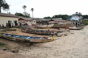 Fishing boats in Bakau, Gambia
 -
 Children swimming near Lamin Lodge.
 -
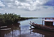 The river.
 -
 River bird
 -
 A market.
 -
 The Spotted hyena is part of the Gambian fauna.
 -
 Wild hippopotamus in the Gambia River.


See also
References
![]() This article incorporates public domain material from The World Factbook.
This article incorporates public domain material from The World Factbook.
Notes
- ^ Donald R. Wright (2004). The World and a Very Small Place: A History of Globalization in Niumi, The Gambia (New York: M.E. Sharp) p. 151–152.
- ^ Craig Emms and Linda Barnett (2001). Bradt Travel Guide for The Gambia (Chalford, UK: Bradt Travel Guides).
- ^ Global Environment Facility, United Nations Environment Programme (eds.): The Gambia’s Second National Communication under the United Nations Framework Convention on Climate Change[permanent dead link]. Banjul, November 2012, p. 32.
- ^ The World Factbook: The Gambia. Chapter Geography and map.
- National Imagery and Mapping Agency. Map data from 1966.
- ^ "Gambia High Point". peakbagger.com..
- ^ Malanding S. Jaiteh, Baboucarr Sarr: Climate Change and Development in the Gambia: Challenges to Ecosystem Goods and Services, p. 1–3. Map based on: The Gambia 50,000 database 2003 topographic data. Department of Local Government and Lands.