
Geography of the United Arab Emirates
 | |
| Continent | Asia |
|---|---|
| Region | Middle East |
| Coordinates | 24°N 54°E / 24°N 54°E |
| Area | Ranked 114th |
| • Total | 83,600 km2 (32,300 sq mi) |
| • Land | 100% |
| • Water | 0% |
| Coastline | 1,318 km (819 mi) |
| Borders | total: 867 km (539 mi) |
| Highest point | Jabal ar Rahrah 1,691 m (5,548 ft) [1] |
| Lowest point | Persian Gulf 0 m |
| Longest river | None |
| Largest lake | Lake Zakher |
| Climate | arid; mild, pleasant winters; very hot, humid summers |
| Terrain | mountainous and barren desert covered with loose sand and gravel |
| Natural resources | petroleum, natural gas, marine resources |
| Natural hazards | haze, dust storms, sandstorms common |
| Environmental issues | limited natural freshwater resources are increasing dependence on large-scale desalination facilities |
| Exclusive economic zone | 58,218 km2 (22,478 sq mi) |
The United Arab Emirates is situated in the Middle East and West Asia, bordering the Gulf of Oman and the Persian Gulf, between Oman and Saudi Arabia; it is at a strategic location along the northern approaches to the Strait of Hormuz, a vital transit point for world crude oil.[2] The UAE lies between 22°50′ and 26° north latitude and between 51° and 56°25′ east longitude.[3] It shares a 19 km (12 mi) border with Qatar on the northwest, a 530 km (330 mi) border with Saudi Arabia on the west, south, and southeast, and a 450 km (280 mi) border with Oman on the southeast and northeast.[3]
The land border with Qatar in the
Boundaries

The UAE stretches for more than 650 km (400 mi) along the southern shore of the Persian Gulf.
These northern emirates on the Persian Gulf and Gulf of Oman are part of the Gulf of Oman desert and semi-desert ecoregion.[5]
South and west of Abu Dhabi, vast, rolling sand
Prior to withdrawing from the area in 1971,
-
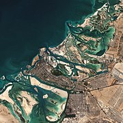 The coast of Abu Dhabi
 -
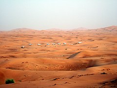 An organised dune-bashing safari in the Emirate of Dubai


Mountains
The UAE also extends for about 90 km (56 mi) along the
-

-
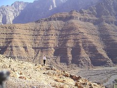 The mountainous region of Al-Hajar Mountains near Hatta in northern UAE
 -
 Jabal ar Rahrah (1,691 m), Emirate of Ras al Khaimah


Climate
.svg)
The climate of the UAE generally is very hot and sunny.[3] The hottest months are July and August, when average maximum temperatures reach above 48 °C (118.4 °F) on the coastal plain.[3] In the Western Hajar Mountains, temperatures are considerably cooler, a result of increased altitude.[3] Average minimum temperatures in January and February are between 10 and 14 °C (50.0 and 57.2 °F).[3] During the late summer months, a humid southeastern wind known as the sharqi makes the coastal region especially unpleasant.[3] The average annual rainfall in the coastal area is less than 120 mm (4.7 in), but in some mountainous areas annual rainfall often reaches 350 mm (13.8 in).[3] Rain in the coastal region falls in short, torrential bursts during the summer months, sometimes resulting in floods in ordinarily dry wadi beds.[3] The region is prone to occasional, violent dust storms, which can severely reduce visibility.[3] The Jebel Jais mountain cluster in Ras Al Khaimah has experienced snow only four times (2004, 2009, 2017 and 2020) since records began.[6][7]
| Climate data for Dubai (1977–2015 normals) | |||||||||||||
|---|---|---|---|---|---|---|---|---|---|---|---|---|---|
| Month | Jan | Feb | Mar | Apr | May | Jun | Jul | Aug | Sep | Oct | Nov | Dec | Year |
| Record high °C (°F) | 31.8 (89.2) |
37.5 (99.5) |
41.3 (106.3) |
43.5 (110.3) |
47.0 (116.6) |
47.9 (118.2) |
48.5 (119.3) |
48.8 (119.8) |
45.1 (113.2) |
42.4 (108.3) |
38.0 (100.4) |
33.2 (91.8) |
48.8 (119.8) |
| Mean daily maximum °C (°F) | 23.9 (75.0) |
25.4 (77.7) |
28.9 (84.0) |
33.3 (91.9) |
37.7 (99.9) |
39.8 (103.6) |
40.9 (105.6) |
41.3 (106.3) |
38.9 (102.0) |
35.4 (95.7) |
30.6 (87.1) |
26.2 (79.2) |
33.5 (92.3) |
| Daily mean °C (°F) | 19.1 (66.4) |
20.5 (68.9) |
23.6 (74.5) |
27.5 (81.5) |
31.4 (88.5) |
33.4 (92.1) |
35.5 (95.9) |
35.9 (96.6) |
33.3 (91.9) |
29.8 (85.6) |
25.4 (77.7) |
21.2 (70.2) |
28.1 (82.5) |
| Mean daily minimum °C (°F) | 14.3 (57.7) |
15.5 (59.9) |
18.3 (64.9) |
21.7 (71.1) |
25.1 (77.2) |
27.3 (81.1) |
30.0 (86.0) |
30.4 (86.7) |
27.7 (81.9) |
24.1 (75.4) |
20.1 (68.2) |
16.3 (61.3) |
22.6 (72.6) |
| Record low °C (°F) | 7.7 (45.9) |
7.4 (45.3) |
11.0 (51.8) |
13.7 (56.7) |
15.7 (60.3) |
21.3 (70.3) |
24.1 (75.4) |
24.0 (75.2) |
22.0 (71.6) |
15.0 (59.0) |
10.8 (51.4) |
8.2 (46.8) |
7.4 (45.3) |
| Average precipitation mm (inches) | 18.8 (0.74) |
25.0 (0.98) |
22.1 (0.87) |
7.2 (0.28) |
0.4 (0.02) |
0.0 (0.0) |
0.8 (0.03) |
0.0 (0.0) |
0.0 (0.0) |
1.1 (0.04) |
2.7 (0.11) |
16.2 (0.64) |
94.3 (3.71) |
| Average precipitation days | 5.5 | 4.7 | 5.8 | 2.6 | 0.3 | 0.0 | 0.5 | 0.5 | 0.1 | 0.2 | 1.3 | 3.8 | 25.3 |
| Mean monthly sunshine hours | 251 | 241 | 270 | 306 | 350 | 345 | 332 | 326 | 309 | 307 | 279 | 254 | 3,570 |
| Mean daily sunshine hours | 8.1 | 8.6 | 8.7 | 10.2 | 11.3 | 11.5 | 10.7 | 10.5 | 10.3 | 9.9 | 9.3 | 8.2 | 9.8 |
| Source 1: Dubai Meteorological Office[8] | |||||||||||||
| Source 2: UAE National Center of Meteorology[9] | |||||||||||||
| Climate data for Abu Dhabi | |||||||||||||
|---|---|---|---|---|---|---|---|---|---|---|---|---|---|
| Month | Jan | Feb | Mar | Apr | May | Jun | Jul | Aug | Sep | Oct | Nov | Dec | Year |
| Record high °C (°F) | 33.7 (92.7) |
38.1 (100.6) |
43.0 (109.4) |
44.7 (112.5) |
46.9 (116.4) |
48.8 (119.8) |
52.7 (126.9) |
49.2 (120.6) |
47.7 (117.9) |
43.0 (109.4) |
38.0 (100.4) |
33.4 (92.1) |
52.7 (126.9) |
| Mean daily maximum °C (°F) | 24.1 (75.4) |
26.0 (78.8) |
29.5 (85.1) |
34.5 (94.1) |
39.3 (102.7) |
40.8 (105.4) |
42.1 (107.8) |
42.7 (108.9) |
40.4 (104.7) |
36.5 (97.7) |
31.1 (88.0) |
26.3 (79.3) |
34.4 (94.0) |
| Daily mean °C (°F) | 18.8 (65.8) |
19.6 (67.3) |
22.6 (72.7) |
26.4 (79.5) |
31.2 (88.2) |
33.0 (91.4) |
34.9 (94.8) |
35.3 (95.5) |
32.7 (90.9) |
29.1 (84.4) |
24.5 (76.1) |
20.8 (69.4) |
27.4 (81.3) |
| Mean daily minimum °C (°F) | 13.2 (55.8) |
14.6 (58.3) |
17.5 (63.5) |
20.8 (69.4) |
23.8 (74.8) |
26.1 (79.0) |
28.8 (83.8) |
29.5 (85.1) |
26.6 (79.9) |
23.2 (73.8) |
18.7 (65.7) |
15.8 (60.4) |
21.5 (70.8) |
| Record low °C (°F) | 8.0 (46.4) |
5.0 (41.0) |
8.4 (47.1) |
11.2 (52.2) |
16.0 (60.8) |
19.8 (67.6) |
22.2 (72.0) |
23.8 (74.8) |
19.0 (66.2) |
12.0 (53.6) |
10.5 (50.9) |
7.1 (44.8) |
5.0 (41.0) |
| Average precipitation mm (inches) | 7.0 (0.28) |
21.2 (0.83) |
14.5 (0.57) |
6.1 (0.24) |
1.3 (0.05) |
0 (0) |
0 (0) |
1.5 (0.06) |
0 (0) |
0 (0) |
0.3 (0.01) |
5.2 (0.20) |
57.1 (2.24) |
| Average precipitation days (≥ 0.2 mm) | 1.2 | 2.8 | 2.8 | 1.2 | 0.1 | 0.0 | 0.0 | 0.1 | 0.0 | 0.0 | 0.2 | 1.5 | 9.9 |
| Average relative humidity (%)
|
68 | 67 | 63 | 58 | 55 | 60 | 61 | 63 | 64 | 65 | 65 | 68 | 63 |
| Average dew point °C (°F) | 12 (54) |
12 (54) |
12 (54) |
14 (57) |
16 (61) |
20 (68) |
22 (72) |
21 (70) |
22 (72) |
19 (66) |
16 (61) |
13 (55) |
17 (62) |
| Mean monthly sunshine hours | 246.1 | 232.6 | 251.1 | 280.5 | 342.2 | 336.9 | 314.2 | 307.5 | 302.4 | 304.7 | 286.6 | 257.6 | 3,462.4 |
| Source 1: NOAA (1971–1991)[10] | |||||||||||||
| Source 2: Climate Yearly Report (2003-2020)[11]
Source 3: Time and Date (dewpoints, between 2005-2015)[12] | |||||||||||||
Flora and fauna
The region's indigenous fauna had previously come close to extinction due to intensive hunting, which led to a 1970s conservation program on the
-
 Acacia tortilis in Sharm-Dabna, Fujairah Emirate
 -


Area and land boundaries

Area:
Land boundaries:
- Total: 1,066 km (662 mi)[2]
- Border countries: Oman 609 km (378 mi); Saudi Arabia 457 km (284 mi)[2]
Coastline: 1,318 km (819 mi)[2]
Maritime claims:
- Contiguous zone: 24 nmi (27.6 mi; 44.4 km)[2]
- Continental shelf: 200 nmi (230.2 mi; 370.4 km) or to the edge of the continental margin[2]
- Exclusive economic zone: 200 nmi (230.2 mi; 370.4 km)[2]
- Territorial sea: 12 nmi (13.8 mi; 22.2 km)[2]
Elevation extremes:
- Lowest point: Persian Gulf 0 m[2]
- Highest point: Jebel Al Mebrah 1,527 m (5,010 ft)[a][2]
Resources and land use
- Natural resources: petroleum, natural gas[2]
- Land use:[2]
- Arable land: 0.5%
- Permanent crops: 0.5%
- Permanent pasture: 3.6%
- Forest: 4.5%[16]
- Other: 91.6% (2018)
- Irrigated land: 923 km2 (356 sq mi) (2012)
- Total renewable water resources: 150,000,000 cubic metres (5.3×10⁹ cu ft)[2]
Environmental concerns
- Natural hazards: frequent sand and dust storms[2]
- Environment - current issues: air pollution; rapid population growth and high energy demand contribute to water scarcity; lack of natural freshwater resources being overcome by desalination plants; desertification; beach pollution from oil spills[2]
- Environment - international agreements: party to:
- Signed, but not ratified: Law of the Sea[2]
See also
- List of United Arab Emirates-related topics
Notes
- ^ Jebel Jais is the highest mountain in the UAE with a height of 1,934 m (6,345 ft), but because its peak is in Oman, Jebel Yibir or Mebrah has the highest peak[14][15]
References
- ^ "Jabal ar Rahrah - United Arab Emirates | peakery".
- ^ a b c d e f g h i j k l m n o p q r s t u "United Arab Emirates". The World Factbook. Central Intelligence Agency. August 23, 2021. Retrieved September 1, 2021.
 This article incorporates text from this source, which is in the public domain.
- ^ OCLC 29548413.) This article incorporates text from this source, which is in the public domain.
{{cite encyclopedia}}: CS1 maint: postscript (link - S2CID 56481043.
- ^ "Gulf of Oman desert and semi-desert". Terrestrial Ecoregions. World Wildlife Fund.
- ^ Nasouh Nazzal (2009-01-24). "Heavy snowfall on Ras Al Khaimah's Jebel Jais mountain cluster". Gulf News. Archived from the original on 2009-02-02. Retrieved 2009-01-31.
- ^ "Watch: Snowfall in UAE, temperature hits -2.2 degree". Khaleej Times. 2017-02-04. Retrieved 2017-02-05.
- ^ "Climate (Average Temperatures:1977–2015;Precipitation:1967-2009)". Dubai Meteorological Office. Archived from the original on 4 October 2013. Retrieved 14 February 2019.
- ^ "Climate Yearly Report 2003–2018". UAE National Center of Meteorology NCM. Archived from the original on 15 February 2019. Retrieved 14 February 2019.
- ^ "Climate Normals for Abu Dhabi". National Oceanic and Atmospheric Administration. Retrieved 10 February 2013.
- ^ "Climate Yearly Report Abu Dhabi International Airport". UAE National Center of Meteorology. Retrieved 29 May 2021.
- ^ "Climate & Weather Averages at Abu Dhabi Bateen Airport weather station (41216)". Time and Date. Retrieved 6 February 2022.
- ^ Ebrahimi, Soraya. "Scientists ensure survival of Arabian oryx". The National News. Retrieved 28 October 2022.
- ^ "Jabal Yibir". Dangerousroads.org. Retrieved 2019-02-12.
- ^ "Geography of United Arab Emirates, Landforms - World Atlas". www.worldatlas.com. Retrieved 2017-03-27.
- ^ "Forest area (% of land area) - United Arab Emirates". worldbank.org. Retrieved 18 April 2023.
| Sovereign states |
|
|---|---|
| States with limited recognition |
|
| Dependencies and other territories |
|