
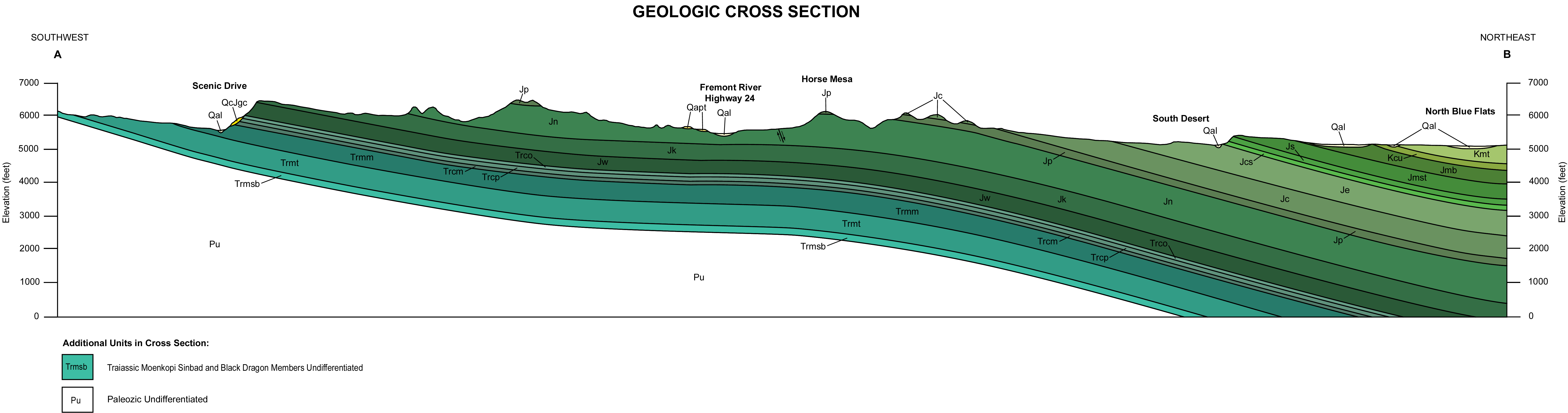
Geology of the Capitol Reef area


The exposed geology of the Capitol Reef area presents a record of mostly Mesozoic-aged sedimentation in an area of North America in and around Capitol Reef National Park, on the Colorado Plateau in southeastern Utah.
Nearly 10,000
The area's first known sediments were laid down as a shallow sea invaded the land in the Permian. At first
From 70 to 50 million years ago the

Primary deposition of sediments
Some important concepts: A
The various kinds of unconformities are gaps in the geologic record. Such gaps can be due to a prolonged absence of deposition or due to subsequent erosion that removes previously deposited rock units. The following sections are ordered from oldest to youngest rock units in order to create a geologic history of events. This is the opposite order one would see in an actual cross section of the sediments because newer rock units are deposited on top of older ones per the law of superposition.
Cutler and Kaibab formations (Permian)

In early
- White Rim Sandstone, (resistant caprock)
- Organ Rock Shale(locally missing),
- Cedar Mesa Sandstone, and the
- Elephant Canyon (locally buried).
Only the two sandstone members of the Cutler Formation, the Cedar Mesa and White Rim, are exposed in the park but they cannot be easily distinguished from each other and are thus often treated as a single stratigraphic unit there.
Good outcrops of the locally 800
Later in Permian time, the
Moenkopi Formation (Triassic)

Local climatic conditions were wetter and more tropical in the Early
- Black Dragon Member
- Sinbad Limestone Member,
- Torrey Member, and
- Moody Canyon Member.
Distinctive exposures of the uppermost Moenkopi are along the lower slopes of the west-facing cliffs of the Waterpocket Fold. Uplift and subsequent partial erosion of the Moenkopi then created an approximately 6 million year long unconformity that lasted the entire Mid Triassic.[6]

The 50 to 110 foot (15 to 34 m) thick slope-forming Black Dragon is composed of reddish
Later in the early Triassic, fossil-rich to muddy limey ooze with small amounts of silt and
A tidal flat briefly returned to the area after the sea retreated. This created the locally 250 to 320 foot (76 to 98 m) thick reddish-brown to chocolate colored siltstone and fine-grained sandstone of the Moenkopi's Torrey Member..
The youngest member of the Moenkopi is the 320 to 430 foot (98 to 130 m) thick Moody Canyon Member. Moody Canyon is informally sub-divided into two units:[10]
- a lower slope-forming 200 to 300 foot (60 to 90 m) thick unit of reddish-brown siltstone and
- an upper cliff-forming 120 to 130 foot (37 to 40 m) thick unit of reddish-orange siltstone.
About 30 to 40% of the stone in the upper unit is ripple-laminated while the lower unit is structureless to horizontally laminated.[10] Good exposures of the ripple-laminated upper unit are found on the lower part of Egyptian Temple.
Chinle Formation (Triassic)

A complex, relatively high velocity and likely braided stream system covered most of southern Utah in the Late Triassic. Various members of the resulting
- Shinarump Member,
- Monitor Butte Member,
- Petrified Forest Member, and
- Owl Rock Member.
Together they form the purple and orange rounded slopes and hills that are occasionally above white cliffs along the Waterpocket Fold's west face.[10]
Discontinuous beds of sediment were deposited in broad channels eroded into the Moenkopi, creating the locally 0 to 90 foot (0 to 27 m) thick white to yellowish gray cliff-forming Shinarump Member of the Chinle Formation.[10] The Shinarump is made of low to high-angle cross-stratified and friable fine to coarse-grained sandstone interbedded with conglomerate. Good outcrops of the Shinarump are found near the park's west entrance capping such features as the Egyptian Temple and Chimney Rock while all traces of this member are absent further east. Members above the Shinarump tend to be finer due to the slower speed of the streams that deposited them.[7]
A river system then migrated northward and transitioned into either a large lake or
Very sinuous rivers covered the area in later Triassic time, forming the sediments of the Chinle's Petrified Forest Member. The Petrified Forest is composed of reddish-orange bentonite-rich cross-bedded siltstones and clayey fine-grained
Deposition from a series of lakes then dominate the geologic record, resulting in the locally 150 to 200 foot (45 to 60 m) thick Owl Rock Member of the Chinle.
Glen Canyon Group (Triassic)

All three formations of the Glen Canyon Group were laid down in the Mid to Late Triassic during a time of increasing aridity. Slightly clockwise and northward movement of the North American Plate was bringing the area into a dryer climatic belt. The direction of cross-bedding in Glen Canyon Group sand dunes suggests that prevailing winds from the north transported the sand into the region.[3] Outcrops of the Glen Canyon Group's three formations are the most prominently exposed rock layers in the spine of the Waterpocket Fold.[7] Together they reach a thickness of 1,500 to 2,700 feet (460 to 820 m) in the area and their sandstones are seen in many of the arches, domes and slot canyons in Capitol Reef.[11] They are, from oldest (lowest) to youngest (highest);
Sand dunes migrated back and forth on the shore of the Sundance Sea, creating the 350 foot (107 m) thick cliff-forming Wingate Sandstone.[7] This formation is composed of orange-colored cross bedded fossilized sand dunes made of fine-grained and well-rounded quartz sand. Wingate outcrops are found capping the Waterpocket Fold's western escarpment. Prominent examples are easy to see near the Visitor Center in the Fruita Cliffs and in The Castle.

The climate became more

A massive
San Rafael Group (Jurassic)
Frequent but short-lived changes in sea level during the Mid to Late Jurassic periodically flooded the area with shallow extensions of the ocean.[11] The resulting San Rafael Group is composed of four formations that were deposited on top of the Glen Canyon Group's regionally traceable erosion surface. San Rafael Group formations are (from oldest to youngest);
San Rafael formations can be seen on the east-dipping part of the Waterpocket Fold.
Climatic conditions were still arid when the locally 0 to 100 feet (0 to 30 m) thick Page Sandstone was deposited above the reach of high tide yet near the shore of an advancing sea (sabkha-like conditions).[12] This formation is composed of three members; the
- Harris Wash,
- Judd Hollow, and the
- Thousand Pockets.
Together they were laid on top of the Navajo sand dunes as the sea slowly flooded the vast desert. An outcrop of the Judd Hollow Member can be seen from mile marker 86.5 as a red cliff above the Fremont River falls. The cross-bedded sandstone just above the red cliff is an example of the Thousand Pockets Member.

In Mid Jurassic time
A near-shore environment dominated by barrier islands, sand bars and tidal flats later returned to the region. The sand and silt deposited created the 400 to 900 foot (120 to 275 m) thick reddish orange Entrada Sandstone.[14] Distinctive jointing systems in the Entrada lead to the formation of cathedrals and monoliths in Capitol Reef's Cathedral Valley, arches in Arches National Park and 'goblins' (the local name for hoodoos) in nearby Goblin Valley State Park. Entrada exposures in the southern part of the park are mostly made of flat-bedded siltstones and erode into slopes. Moving north, Entrada exposures increasingly become rich in cross-bedded sandstone and erode into cliffs with fewer and fewer slopes.
Fine-grained sand and silt mixed with sandy lime were laid down as sediments on top of the Entrada Sandstone, forming the locally 0 to 175 foot (53 m) thick erosion-resistant Curtis Formation.[14] A green iron potassium silicate called glauconite in the Curtis indicates it was deposited in a shallow sea. Outcrops of the light grayish-green Curtis can be seen as a capstone in the northern section of the park while it is locally absent in the southern part.
Tidal flat conditions returned as the shallow sea that created the Curtis Formation retreated from land. Thin beds of reddish-brown mudstone alternating with less frequent beds of greenish-gray sandstone and limestone were deposited as sediments, forming the locally 50 to 250 foot (15 to 75 m) thick Summerville Formation.[14] This formation erodes into ledgy cliffs and slopes and can be seen above Curtis caprock in Cathedral Valley. Fossilized mudcracks and ripple marks are found in the Curtis along with up to 28 foot (8.5 m) thick gypsum-rich beds.
Morrison Formation (Jurassic)

Again above sea level, streams laid down mud and sand in their channels, on lakebeds, and in swampy plains during the Upper Jurassic. This became the Morrison Formation, which is locally divided into three members (from oldest to youngest);
- Tidwell Member,
- Salt Wash, and
- Brushy Basin.
The 50 to 100 foot (15 to 30 m) thick Tidwell Member is locally difficult to recognize and therefore may or may not be in the area's rocks.[14] Easier to identify and study outcrops elsewhere in southeastern Utah indicate they were deposited in hypersaline lagoons.
Clay, mud, silt, cross-bedded sand, and pebbles were later deposited by meandering streams and in
The 200 to 350 foot (60 to 105 m) thick Brushy Basin Member is composed of claystone, mudstone, and siltstone with small amounts of conglomerate and sandstone.[14] Clays in this member are rich in smectite and thus tend to swell when wet and dry to a crumbled surface that looks a bit like popcorn. Fossilized dinosaur bones are abundant in this member in several places located in Utah and western Colorado. The bones are usually scattered and are thus hard to identify but nearly complete skeletons have been found in lake floor and flood-plain clays. Good exposures of the Brushy Basin Member can be seen in the Bentonite Hills.
Cedar Mountain and Dakota formations (Cretaceous)

Early Cretaceous time brought continental deposition that was dominated by rivers to the area. Sandstones and mudstones accumulated to form the 0 to 166 foot (50.5 m) thick slope-forming
The passive continental margin became active when the Farallon Plate started to dive below the North American Plate. Geologists call the resulting mountain-building event the Sevier orogeny. Compressive forces detached sedimentary units across western Utah and Nevada from their Precambrian basement rocks and pushed them eastward.[3] The weight of the resulting high mountain range that formed to the west, lowered much of Utah and allowed the sea to invade. This grew into a vast sea that periodically divided North America in the Cretaceous called the Western Interior Seaway.[17]
Non-marine sediments of the approximately 100- to 94-million-year-old
Mancos Shale and Mesaverde Formation (Cretaceous)
Approximately 94 to 85 million years ago, the seaway advanced onto and retreated from land as it laid down the Mancos Shale.[17] The Mancos is composed mostly of shale but two of its members, the Ferron and Muley Canyon, are sandstone that were laid down when relative sea level temporarily dropped. The five Mancos members from oldest to youngest are:
- Tununk Shale,
- Ferron Sandstone,
- Blue Gate Shale,
- Muley Canyon, and
- Masuk.

Parts of this formation are found in some
Open marine conditions created the locally 40 to 720 feet (12 to 220 m) thick gullied slope-forming Tununk Shale Member. It is made of bluish-gray shale with interbedded mudstone, fine-grained sandstone and siltstone. The Tununk erodes into a slope and is locally fossil-rich.[20] It is most prominently exposed in the Blue Desert immediately southeast of Cathedral Valley and contains fossilized examples of cephalopods, bivalves, and fish scales.
A wave-dominated

Open marine conditions returned in the Late Cretaceous, forming the locally 1,200 to 1,500 foot (365 to 460 m) thick slope-forming Blue Gate Shale. This member is composed of bentonite rich clays, siltstone and some sandstone. It erodes into gullied slopes similar in appearance to the Tununk Shale. The presence of two species of planktonic foraminifera in the upper Blue Gate, Clioscaphites vermiformis and Clioscaphites choteauenis, was used to date this member.
An ancient shoreline once again approached the area, resulting in the formation of the locally 300 to 400 feet (90 to 120 m) thick Muley Canyon Member. It is composed of evenly bedded, fine-grained sandstone and carbon-rich shales. Coal beds are found in the upper parts of this member, indicating continental coastal plain conditions at that time.
Alternating layers of shallow marine and non-marine sediments were deposited as the shoreline fluctuated back and forth over the area. These sediments became the locally 650 to 750 foot (200 to 230 m) thick Masuk Member.[21] The Masuk consists of cliff-forming cross-bedded sandstones and slope-forming yellowish-gray to bluish-gray mudstones with interbedded light gray sandstones. Fossils of bivalves, ceratopsian dinosaurs, crocodiles, gastropods, and turtles have been collected in this member.[21]
The Western Interior Seaway was shrinking due to infilling and uplift while the high mountains to the east were being reduced by erosion. Barrier
Uplift and Cenozoic events
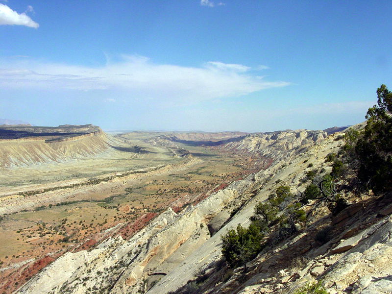
Waterpocket Fold, Lake Uinta and volcanism

Photo of the fold looking south from the Strike Valley Overlook (USGS)
The Laramide orogeny compacted the region from about 70 million to 50 million years ago and in the process created the Rocky Mountains. Many monoclines (a type of gentle upward fold in rock strata) were also formed by the deep compressive forces of the Laramide. One of those monoclines, called the Waterpocket Fold, is the major geographic feature of the park. The 100 mile (160 km) long fold has a north–south alignment with a steeply east-dipping side. The rock layers on the west side of the Waterpocket Fold have been lifted more than 7,000 feet (2,100 m) higher than the layers on the east.[23] Thus older rocks are exposed on the western part of the fold and younger rocks on the eastern part. This particular fold may have been created due to movement along a fault in the Precambrian basement rocks hidden well below any exposed formations. Small earthquakes centered below the fold in 1979 may be from such a fault.[24]
Contemporary with the Waterpocket Fold's formation was the development of an intermontane (between mountains) basin in the area.
Compressive forces caused by the Laramide
Erosion

Ten to fifteen million years ago the entire region was uplifted several thousand feet (well over a kilometer) by the creation of the Colorado Plateaus. This time the uplift was more even, leaving the overall orientation of the formations mostly intact. Most of the erosion that carved today's landscape occurred after the uplifting of the Colorado Plateau with much of the major canyon cutting probably occurring between 1 and 6 million years ago.[26] Even in this desert climate, water is the erosional agent most responsible for the carving of the landscape. The pull of gravity, in the form of rock falls or rock creep, plays a major role in the shaping of the cliff lines. Wind is a minor agent of erosion here.
The drainage system in the area was rearranged and steepened as the Waterpocket Fold was uplifted. Larger streams, such as the

Wetter and cooler conditions developed during the
References
Works cited
- Billingsley, G.H., Breed, W.J. and Huntoon, P.W.; 1987; Geologic Map of capitol Reef National Park and vicinity, Utah; Utah Geologic Survey (viewed March 25, 2006)
- Halka Chronic, Roadside Geology of Utah (Mountain Press; 1990) ISBN 0-87842-228-5
- Ann G. Harris, Esther Tuttle, Sherwood D., Tuttle, Geology of National Parks: Fifth Edition (Iowa, Kendall/Hunt Publishing; 1997) ISBN 0-7872-5353-7
- L. F. Hintze, Geologic History of Utah, Brigham Young University Geology Studies, v. 20, Part 3. Provo UT, page 181
- Thomas H. Morris, Vicky Wood Manning, and Scott M. Ritter, "Geology of Capitol Reef National Park, Utah" in Geology of Utah's Parks and Monuments, Douglas A. Sprinkel, Thomas C. Chindsey, Jr., and Paul B. Anderson, Editors (Salt Lake City; Utah Geological Association; 2003) ISBN 1-882054-10-5
- National Park Service, "Capitol Reef: Geology" (viewed March 25, 2006)
- William Lee Stokes, Geology of Utah (Salt Lake City; Utah Museum of Natural History; 1988) ISBN 0-940378-05-1
Notes
- ^ NPS, "Capitol Reef"
- ^ Stokes, 1988, page 95, paragraph 3
- ^ a b c d Morris et al., 2003, page 96, Tectonics and Geologic History"
- ^ 'Cutler Formation' is the accepted usage by the USGS while 'Cutler Group' is preferred by the Utah Geological Survey, according to the GEOLEX database entry for 'Cutler'. Accessed March 18, 2006
- ^ Morris et al., 2003, page 86, "Culter Group", paragraph 1
- ^ a b c d e f g Morris et al., 2003, page 90
- ^ a b c d e f g Harris et al., 1997, page 62
- ^ a b c Morris et al., 2003, page 90, "Kaibab Limestone"
- ^ Morris et al., 2003, page 90 to 91, "Moenkopi Formation"
- ^ a b c d e f g h i j Morris et al., 2003, page 91
- ^ a b c d e Morris et al., 2003, page 92
- ^ Morris et al., 2003, pages 92–93
- ^ Harris et al., 1997, page 63, section 4, paragraph 1
- ^ a b c d e f g Morris et al., 2003, page 94
- ^ Harris et al., 1997, page 64, section 5
- ^ a b Morris et al., 2003, page 95
- ^ a b c d e f g Morris et al., 2003, page 97
- ^ Morris et al., 2003, page 95, "Dakota Sandstone"
- ^ Harris et al., 1997, page 65, section 6, paragraph 2
- ^ a b c Billingsley et al., 1987, page 5
- ^ a b Morris et al., 2003, page 95, "Mancos Shale"
- ^ Morris et al., 2003, pages 95–96, "Mesaverde Formation" and Billingsley et al., 1987, page 5
- ^ NPS, "Geology", paragraph 1
- ^ Harris et al., 1997, page 65, section 7
- ^ Harris et al., 1997, page 60, "Igneous Rocks"
- ^ NPS, "Erosion"
- ^ Harris et al., 1997, page 66, section 9, paragraph 1
- ^ Morris et al., 2003, page 98, paragraph 1
- ^ Harris et al., 1997, page 66, section 9
- ^ Hintze, 1973
- ^ Harris et al., 1997, page 60, "Igneous Rocks", paragraph 2