
Georg Braun

Georg Braun (also Brunus, Bruin; 1541 – 10 March 1622) was a German topo-geographer.[1] From 1572 to 1617, he edited the Civitates orbis terrarum, which contains 546 prospects, bird's-eye views and maps of cities from all around the world.[2] As principal editor of the work, he acquired the tables, hired the artists, and wrote the texts. He died as an octogenarian in 1622, the only survivor of the original team to witness the publication of volume VI in 1617.
Biography

Braun was born and died in
Theatrum orbis terrarum by Abraham Ortelius
, as Ortelius was interested in a complementary companion for the Theatrum.
The Braun publication set new standards in cartography for over 100 years.
Sources
- James Elliot (1987), The City in Maps: Urban Mapping to 1900, British Library London, ISBN 0-7123-0134-8
- Ronald Vere Tooley (1979), Tooley's Dictionary of Mapmakers, ISBN 0-8451-1701-7
- Leo Bagrow, Abraham Ortelius: A. Ortelii Catalogus Cartographorum, J. Perthes (1928)
Gallery
-
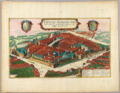
 Hamburg (Hamburgum)
 -
 Kronborg Castle and the Øresund
 -
 Leipzig (Lipsae Insignis)
 -
 Mexico City and Cuzco
 -
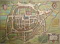
 Nijmegen (Noviomagum)
 -
 Braga (Bracara Augusta)
 -
 Coimbra (Conimbriae)
 -
 Lisbon (Olissipona)
 -
 Paris (Lutetia)
 -
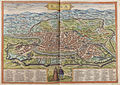 Rome (Roma)
.jpg)


_ca_1570.jpg)

.jpg)


References
- ^ Neue Deutsche Biographie
- ^ "Civitates orbis terrarum - Braun and Hogenberg". Historic-cities.huji.ac.il. Retrieved 15 January 2014.
- ^ "Map of Cairo, 1572, Braun and Hogenberg".
- ^ "Map of Casablanca, 1572, Braun and Hogenberg". Historic-cities.huji.ac.il. Retrieved 15 January 2014.
- ^ "Map of Mexico City & Cuzco, 1572, Braun and Hogenberg". Historic-cities.huji.ac.il. Retrieved 15 January 2014.
- ^ "Map of Tunis, 1575, Braun and Hogenberg".
External links
Wikimedia Commons has media related to Georg Braun.
- Geldner, Ferdinand (1955), "Braun, Georg", Neue Deutsche Biographie (in German), vol. 2, Berlin: Duncker & Humblot, p. 550
- Civitates orbis terrarum (description and high-res scans)
- Civitates orbis terrarum - Braun and Hogenberg
- Georg Braun maps depicting Europe and Mexico at the John Carter Brown Library
| International | |
|---|---|
| National | |
| Academics | |
| Artists | |
| People | |
| Other | |