
Georgian Bay
| Georgian Bay | |
|---|---|
 Taken on March 20, 2022 with Resourcesat-2 | |
 Georgian Bay | |
| Coordinates | 45°30′N 81°00′W / 45.5°N 81.0°W |
| Basin countries | Canada |
| Max. length | 190 km (120 mi)[citation needed] |
| Max. width | 80 km (50 mi)[citation needed] |
| Surface area | 15,000 km2 (5,800 sq mi)[citation needed] |
| Average depth | 150 feet (46 m) near the shoreline of Cabot Head |
| Islands | 31,000+ |
| Settlements | Collingwood Owen Sound Meaford, Ontario Parry Sound Midland Penetanguishene Wasaga Beach Killarney, Ontario |
Georgian Bay (
Georgian Bay is surrounded by (listed
The shores and waterways of the Georgian Bay are the traditional domain of the Anishinaabeg First Nations peoples to the north and Huron-Petun (Wyandot) to the south. The bay was thus a major Algonquian-Iroquoian trade route.
Etymology
Georgian Bay has been known by several names. To the
Geography

Georgian Bay is about 190 kilometres (120 mi) long by 80 kilometres (50 mi) wide.[3] It covers approximately 15,000 square kilometres (5,800 sq mi), making it nearly 80% the size of Lake Ontario.[4][5]
Eastern Georgian Bay is part of the southern edge of the
If Georgian Bay were considered a lake in its own right, it would be the fourth largest lake located entirely within Canada (after Great Bear Lake, Great Slave Lake and Lake Winnipeg). With Georgian Bay, Lake Huron is considered to be the second largest of the Great Lakes - if Georgian Bay were excluded, Lake Huron would be the third largest (after Lake Superior and Lake Michigan, but still ahead of Lake Erie and Lake Ontario).
There are tens of thousands of islands in Georgian Bay. Most of these islands are along the east side of the bay and are collectively known as the "
History

Archaeological records reveal an
During the period of deglaciation, a succession of prehistoric lakes in the Huron basin caused shoreline advance and retreat. The former shoreline of pro-glacial Lake Algonquin left behind high ridges which were attractive sites for human occupation. As shorelines retreated, the highly mobile Paleo-Indian groups of the period were able to migrate northward into this new land.[8]: 56 Declining water levels created two distinct lakes in the Huron basin: Lake Stanley and Lake Hough, the latter of which corresponds to the modern Georgian Bay. Lake Stanley drained into Lake Hough through a spillway. While it is sometimes unclear whether some sites were contemporaneous with shorelines or were located a distance inland,[8]: 56–57 sites are geographically-temporally stratified in correspondence with water levels.
For example, at two sites along Batteaux Creek near modern-day
At the time of European
The first
In 1615, Brulé's employer, the
The first nautical charts of Georgian Bay were made in 1815 by Captain
The Canadian Hydrographic Service traces its history back to 1883, when it was originally established as the Georgian Bay Survey, tasked with charting and improving knowledge of the bay after a steamship wrecked there the previous year, killing 150 of its passengers.
Over the years, 32 lighthouses were built on Georgian Bay. Six of them were designed with limestone towers; these were built in the 1850s and are known collectively as the Imperial Towers. Some of the 32 can be toured by the public, some cannot, and some are accessible only by tour boats or private boat.[9]
Legend of Kitchikewana

Wyandot legend tells of a god called Kitchikewana, who was large enough to guard the whole of the Georgian Bay. Kitchikewana was known for his great temper, and his tribe decided the best way to calm him was with a wife. They held a grand celebration, and many women came. Kitchikewana met a woman named Wanakita here. He decided that this was the woman he wanted to marry, and started planning the wedding immediately after she left. But when she was invited back, she told Kitchikewana that she was already engaged. Enraged, Kitchikewana destroyed all the decorations, running to one end of Beausoleil Island and grabbing a large ball of earth. Running to the other end, he tossed it into the Great Lakes. Thus, the 30,000 Islands were created. The indentations left behind by his fingers form the five bays of Georgian Bay: Midland Bay, Penetang Bay, Hog Bay, Sturgeon Bay, and Matchedash Bay.[10] He then lay down to sleep and sleeps there still as Giant's Tomb Island.
The town of Penetanguishene now has a large statue of Kitchikewana on its main street. There is a YMCA summer camp for youth located on Beausoleil Island, in southern Georgian Bay, named after Kitchikewana.[11] YMCA Camp Kitchikewana, or Kitchi for short, has been located in Georgian Bay Islands National Park since 1919. Originally operated by the Midland YMCA, it is now the residential camp for youth from the YMCA of Simcoe/Muskoka.
Settlements
There are communities of summer cottages on the north and east shore and on the adjacent 30,000 Islands. These include areas such as Cognashene, Wah Wah Taysee, Sans Souci, Pointe au Baril and Byng Inlet. Most of these cottages are accessible only by water.
Images
-
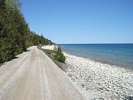 Georgian Bay at Cabot Head
 -
 Reed's dump beach on Georgian Bay near the campsite
 -
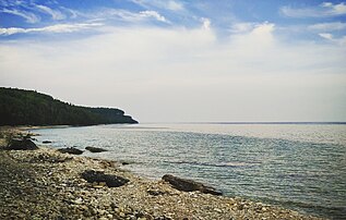
 Shoreline of Georgian Bay
 -
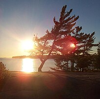
 Sunset over Georgian Bay


See also
- Canadian Shield
- Christian Island (Ontario)
- Galipeau Island
- Royal eponyms in Canada
- True North II
References
- ISBN 0-8020-2495-5.
- ^ a b Ketcheson, Graham. "History of Georgian Bay" (PDF). The Pennsylvania Club. Retrieved November 24, 2022.
- ^ Georgian Bay (bay, Ontario, Canada) - Encyclopædia Britannica. Britannica.com. Retrieved on 2013-07-12.
- ^ Georgian Bay - definition of Georgian Bay by the Free Online Dictionary, Thesaurus and Encyclopedia. Thefreedictionary.com. Retrieved on 2013-07-12.
- ^ "Nearly as large as Lake Ontario, it is one of the world's great bodies of fresh water." (Archived from the original on October 16, 2013.)
- ^ "Great Lakes Sensitivity to Climatic Forcing: Hydrological Models Archived 2010-08-08 at the Wayback Machine." NOAA, 2006.
- OCLC 37863060.
- ^ Ontario Archaeology. 70. Ontario Archaeological Society: 16–65.
- ^ "Lighthouse Tour". Visit Georgian Bay. Georgian Bay Destination Development Partnership. 2017. Retrieved 4 March 2017.
- ^ "The Ouendat (Huron) Indian Legend of Kitchikewana". Archived from the original on October 21, 2007.
- ^ "Overnight Camp" Archived 2010-03-08 at the Wayback Machine on the YMCA of Simcoe/Muskoka website
- ^ "Collingwood · Population". population.city.
- ^ "About | Parry Sound – Downtown Business Association".
Further reading
- Campbell, Claire Elizabeth (2005). ISBN 0-7748-1098-X.
- Ellis, C.; Ferris, N., eds. (1990). The Archaeology of Southern Ontario To 1650. London Chapter, Ontario Archaeological Society. ISBN 0-919350-13-5.
- Hamilton, James Cleland (1893). The Georgian Bay: An Account of Its Position, Inhabitants, Mineral Interests, Fish, Timber and Other Resources. Toronto: James Bain & Son.
- Harris, R. Cole, ed. (1987). Historical Atlas of Canada, Volume I: From the Beginning to 1800. Toronto: University of Toronto Press. ISBN 0-8020-2495-5.
- Markle, Chantel E.; Rutledge, Julia M.; Chow-Fraser, Patricia (September 2018). "Factors Affecting Coastal Wetland Occupancy for Eastern Musk Turtles (Sternotherus odoratus) in Georgian Bay, Lake Huron". S2CID 91169298.
External links
- Native Languages of the Americas
- "Ojibwe History" Shultzman, L. 2000. First Nations Histories. Accessed: 2006-03-28.
- . Encyclopædia Britannica. Vol. 11 (11th ed.). 1911.
- Georgian Bay Islands National Park of Canada, on the Government of Canada Site (in English and French)
Great Lakes of North America | |||||||||||||
|---|---|---|---|---|---|---|---|---|---|---|---|---|---|
| Main lakes | |||||||||||||
| Secondary lakes | |||||||||||||
| Bays and channels |
| ||||||||||||
| Waterways | |||||||||||||
| Islands | |||||||||||||
| Historic geology | |||||||||||||
| Organizations |
| ||||||||||||
| Related topics |
| ||||||||||||
| International | |
|---|---|
| National | |