
German East Africa
German East Africa Deutsch-Ostafrika (German) | |||||||||||||||||||||
|---|---|---|---|---|---|---|---|---|---|---|---|---|---|---|---|---|---|---|---|---|---|
| 1885–1918 | |||||||||||||||||||||
 Service flag of the Colonial Office
 Coat of arms of the German Empire
| |||||||||||||||||||||
Wilhelm II | |||||||||||||||||||||
| Governor | |||||||||||||||||||||
• 1885–1891 (first) | Carl Peters | ||||||||||||||||||||
• 1912–1918 (last) | Heinrich Schnee | ||||||||||||||||||||
| Historical era | New Imperialism | ||||||||||||||||||||
• Established by the DOAG | 27 February 1885 | ||||||||||||||||||||
| 1 July 1890 | |||||||||||||||||||||
| 21 October 1905 | |||||||||||||||||||||
| 3 August 1914 | |||||||||||||||||||||
• Surrender | 25 November 1918 | ||||||||||||||||||||
| 28 June 1919 | |||||||||||||||||||||
| Area | |||||||||||||||||||||
| 1912 | 995,000 km2 (384,000 sq mi) | ||||||||||||||||||||
| Population | |||||||||||||||||||||
• 1912 | 7,700,000 | ||||||||||||||||||||
| Currency | German East African rupie | ||||||||||||||||||||
| |||||||||||||||||||||
German East Africa (GEA; German: Deutsch-Ostafrika) was a German colony in the African Great Lakes region, which included present-day Burundi, Rwanda, the Tanzania mainland, and the Kionga Triangle, a small region later incorporated into Mozambique. GEA's area was 994,996 km2 (384,170 sq mi),[2][3] which was nearly three times the area of present-day Germany and almost double the area of metropolitan Germany at the time.
The colony was organised when the German military was asked in the late 1880s to put down a revolt against the activities of the German East Africa Company. It ended with Imperial Germany's defeat in World War I. Ultimately the territory was divided amongst Britain, Belgium and Portugal, and was reorganised as a mandate of the League of Nations.
History
Like other colonial powers the Germans expanded their empire in the Africa Great Lakes region, ostensibly to fight slavery and the slave trade. Unlike other imperial powers, however they never formally abolished either slavery or the slave trade and preferred instead to curtail the production of new "recruits", regulating the existing business of slavery.[4][page needed]
The colony began when Carl Peters, an adventurer and the founder of the Society for German Colonization, signed treaties with several native chieftains on the mainland which is opposite Zanzibar. On 3 March 1885, the German government announced that it had granted an imperial charter, which was signed by Chancellor Otto von Bismarck on 27 February 1885. The charter was granted to Peters' company and was intended to establish a protectorate in the African Great Lakes region. Peters then recruited specialists who began exploring south to the Rufiji River and north to Witu, near Lamu on the coast.[5][page needed][6][page needed][7][page needed]
The

German rule was established quickly over
The stretch of border between Kenya and Tanganyika, running from the sea to Lake Victoria, was surveyed by two British brothers: Charles Stewart Smith (British Consul at Mombasa) and his younger brother George Edward Smith (an officer and later a general with the Royal Engineers). Stewart Smith had been appointed British Commissioner in 1892 for the delimitation of the Anglo-German Boundary in Africa, and in the same year they both surveyed the 180-mile line from the sea to Mount Kilimanjaro. Twelve years later George Edward Smith returned to complete the survey of the remaining 300 miles from Kilimanjaro to Lake Victoria.[12]
Between 1891 and 1894, the Hehe people which were led by Chief Mkwawa resisted German expansion. They were defeated because rival tribes supported the Germans. After years of guerrilla warfare, Mkwawa was cornered and committed suicide in 1898.[13]
The Maji Maji Rebellion occurred in 1905[14] and was put down by Governor Gustav Adolf von Götzen, who ordered measures to create a famine to crush the resistance. It may have cost as many 300,000 lives.[15][16] Scandal followed with allegations of corruption and brutality. In 1907, Chancellor Bernhard von Bülow appointed Bernhard Dernburg to reform the colonial administration.[17][18]

German colonial administrators relied heavily on native chiefs to keep order and collect taxes. By 1 January 1914, not including local police, the military garrisons of the Schutztruppen (protective troops) in Dar es Salaam, Moshi, Iringa, and Mahenge numbered 110 German officers (including 42 medical officers), 126 non-commissioned officers, and 2,472 Askari (native enlisted men).[19]: 32
Economic development

Germans promoted commerce and economic growth. Over 100,000 acres (40,000 ha) were put under sisal cultivation which was the largest cash crop.[20] Two million coffee trees were planted, rubber trees grew on 200,000 acres (81,000 ha), and there were large cotton plantations.[21]
In the early years of the colony, hunting and gathering remained the basis of the export economy, and ivory and wild rubber were major exports. The African-owned plantations along the coast, on the other hand, suffered from the gradual abolition of slavery. The number of European-owned plantations rose steadily, but many of them proved unprofitable. Global markets for commodities like coffee and rubber were very unstable, and the soil and climate were not always favourable to the grower. It was only in sisal that the large plantations finally found a reliable source of income. [22] Under the governorship of Albrecht von Rechenberg, from 1906 to 1912, the colonial administration began to place more emphasis on the economic potential of African small-holder agriculture, for which railway construction was an essential precondition.[23] In his detailed study of the economic development of the colony, Rainer Tetzlaff came to the conclusion that "German East Africa never achieved any real significance for the German Empire, neither as a colony for the settlement of emigrants, nor as a supplier of raw materials, nor as a market for exports."[24]
One of the great impediments to the development of plantation agriculture was the labour problem. The plantations could not function without a large African workforce, but employment conditions were often poor, not to say life-threatening. Local German officials frequently colluded with European landowners in forcing Africans to work on the plantations, although the government in Berlin had banned any form of forced labour. The various labour ordinances promulgated in Dar es Salaam were largely ignored in the interior. The social and economic impacts of large-scale labour migration on "labour reservoirs" such as Unyamwezi and Usukuma were often devastating.[25] [26][27][28]
Beginning in 1888 the Usambara Railway was built from Tanga to Moshi to bring these agricultural products to market. The Central Railroad covered 775 mi (1,247 km) and linked Dar es Salaam, Morogoro, Tabora, and Kigoma. The final link to the eastern shore of Lake Tanganyika was completed in July 1914 and was cause for a huge and festive celebration in the capital with an agricultural fair and trade exhibition. Harbor facilities were built or improved with electrical cranes, with rail access and warehouses. Wharves were remodeled at Tanga, Bagamoyo, and Lindi. After 1891, the German colonial administration undertook efforts to overhaul the region's caravan routes, which had existed before European colonisation, into all-weather highways, although most of these projects proved to be unsuccessful and ended in failure.[29]
In 1912, Dar es Salaam and Tanga received 356 freighters and passenger steamers and over 1,000 coastal ships and local trading-vessels.[19]: 30 Dar es Salaam became the showcase city of all of tropical Africa.[30]: 22 By 1914, Dar es Salaam and the surrounding province had a population of 166,000, among them 1,000 (0.6%) Germans. In all of the GEA, there were 3,579 Germans.[19]: 155
Gold mining in Tanzania in modern times dates back to the German colonial period, beginning with gold discoveries near Lake Victoria in 1894. The Kironda-Goldminen-Gesellschaft established one of the first gold mines in the colony, the Sekenke Gold Mine, which began operation in 1909 after the finding of gold there in 1907.[31]
Education
Germany developed an educational program for Africans that included elementary, secondary, and vocational schools.[citation needed] "Instructor qualifications, curricula, textbooks, teaching materials, all met standards unmatched anywhere in tropical Africa."[30]: 21 In 1924, ten years after the beginning of the First World War and six years into British rule, the visiting American Phelps-Stokes Commission reported, "In regards to schools, the Germans have accomplished marvels. Some time must elapse before education attains the standard it had reached under the Germans."[30]: 21
The Swahili word for school, shule, is derived from the German word Schule.[32]
Population on the eve of World War I
In the most populous colony of the German Empire, there were more than 7.5 million locals. About 30% were Muslim and the remainder belonged to various tribal beliefs or Christian converts, compared to around 10,000 Europeans, who resided mainly in coastal locations and official residences. In 1913, only 882 German farmers and planters lived in the colony. Approximately 70,000 Africans worked on the plantations of GEA.[33]
World War I

General Paul von Lettow-Vorbeck had served in German South West Africa and Kamerun. He led the German forces in GEA during World War I. His military force consisted of 3,500 Europeans and 12,000 native Askaris and porters. The war strategy was to harry the British army of 40,000, which was at times commanded by the former Second Boer War commander Jan Smuts. One of Lettow-Vorbeck's greatest victories was at the Battle of Tanga (3–5 November 1914). In the battle, the German forces defeated a British force, which was more than eight times larger.[34]
Lettow-Vorbeck's guerrilla warfare compelled Britain to commit significant resources to a minor colonial theatre throughout the war and inflicted more than 10,000 casualties. Eventually, the weight of numbers, especially after forces coming from the Belgian Congo had attacked from the west (Battle of Tabora), and dwindling supplies forced Lettow-Vorbeck to abandon the colony. He withdrew south into Portuguese Mozambique and then into Northern Rhodesia, where he agreed to a ceasefire after he had received news of the armistice between the warring nations three days earlier.[35]
.jpg)
Currency had to be printed locally due to a significant lack of provisions resulting from the naval blockade.
After the war, Lettow-Vorbeck was acclaimed as one of Germany's heroes. His Schutztruppe was celebrated as the only colonial German force during World War I that was not defeated in open combat, but it often retreated when it was outnumbered. The Askari colonial troops who had fought in the East African campaign were later given pension payments by the Weimar Republic and West Germany.[36]
The SMS Königsberg, a German light cruiser, also fought off the coast of the African Great Lakes region. She was eventually scuttled in the Rufiji delta in July 1915 after running low on coal and spare parts and was subsequently blockaded and bombarded by the British. The surviving crew stripped out the remaining ship's guns, mounted them on gun carriages, and joined the land forces, which added considerably to their effectiveness.[37]

Another smaller campaign was conducted on the shores of southern Lake Tanganyika in 1914 and 1915. It involved a makeshift British and Belgian flotilla and the Reichsheer garrison at Bismarckburg (modern-day Kasanga).[citation needed]
Break-up of the colony
The Supreme Council of the
On 12 July 1919, the Commission on Mandates agreed that the small
The Treaty of Versailles was signed on 28 June 1919, although the treaty did not take effect until 10 January 1920. On that date, the GEA was transferred officially to Britain, Belgium, and Portugal. Also on the same day, "Tanganyika" became the name of the British territory.
German placenames
Some names in German East Africa continued to bear German spellings of the local names for a while, such as "Udjidji" for Ujiji and "Kilimandscharo" for Mount Kilimanjaro, "Kleinaruscha" for Arusha-Chini and "Neu-Moschi" for the city now known as Moshi. (Kigoma was known for a time as "Rutschugi".)[40]
Many places were given African names or had their previous names reestablished:[41][42][43][44]
- Alt Langenburg (Ikombe)[42]
- Bergfrieden (Mibirizi)[42]
- Bismarckburg (Kasanga) on the south-eastern end of Lake Tanganyika[43]: v. I, p. 217 [42]
- Emmaberg (Ilembule)[42]
- Fischerstadt (Rombo)[42]
- Friedberg (Nyakanazi)[42]
- Gottorp or Neu-Gottorp (Uvinza) near the northeastern end of Lake Tanganyika
- Hohenfriedeberg (Mlalo)[42]
- Hoffnungshöh (Kisarawe)[42]
- Kaiseraue (Kazimzumbwi)[42]
- Kirondathal (Kirondatal) gold mine
- Langenburg and Neu-Langenburg (Lake Nyasa[42]
- Leudorf (Liganga)[42]
- Mariahilf (Igulwa)[42]
- Marienthal (Ushetu)[42]
- Neu-Bethel (Mnazi)[42]
- Neu-Bonn (Mikese)[42]
- Neu-Hornow (Shume) in the Pare Mountains in the northeast
- Neu-Langenburg (Lumbira)[42]
- Neu-Trier (Mbulu)[42]
- Peterswerft (Nansio)[42]
- Sachsenwald (Sekenke) gold mine
- St. Moritz (Galula)[42]
- Sphinxhafen (Lake Nyasa
- Wiedhafen (Lake Nyasa
- Wilhelmstal or Wilhelmsdorf (Lushoto) on the Pangani River in the northeast
- Wißmannhafen, port of Bismarckburg (Kasanga) on the southeastern end of Lake Tanganyika
List of governors
The Imperial High Commissioners (German: Reichskommissar) and Imperial Governors (German: Kaiserlicher Gouverneur) of German East Africa:[45]
Reichskommissar (1885/88-1891)
- 1888–1891: Hermann Wissmann
- Kaiser Wilhelm IIawarded him the title of “retired Reichskommissar” and from 1914 he also received an annual pension.
Imperial Governors (1891-1918)
- 1891–1893: Julius von Soden
- 1893–1895: Friedrich von Schele
- 1895–1896: Hermann Wissmann
- 1896–1901: Eduard von Liebert
- 1901–1906: Gustav Adolf von Götzen
- 1906–1912: Albrecht von Rechenberg
- 1912–1918: Heinrich Schnee
Maps
-
 Historical map of the German East African coast, 1888
 -
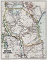 Historical map of German East Africa, 1892
 -
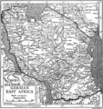 Historical map of German East Africa, 1911
 -
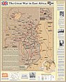 Map of the East African Theater in World War I


Gallery
-
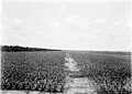 Sisal plantation, c. 1906/18
 -
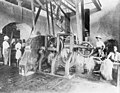 Sisal factory, c. 1906/18
 -
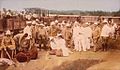
 Askari company, c. 1914/18
 -
 Classroom in a German East African school, c. March 1914
 -
 Usambara Railway, built in German East Africa
 -
 German colonial volunteer mounted patrol, 1914


Planned symbols for German East Africa
In 1914, a series of drafts were made for proposed Coat of Arms and Flags for the German Colonies. However World War I broke out before the designs were finished and implemented and the symbols were never actually used. Following its defeat in the war, Germany lost all its colonies and the prepared coat of arms and flags as a result were never used.[citation needed]
-
 Proposed flag
 -
 Proposed coat of arms


See also
References
- ^ Michael Pesek: Das Ende eines Kolonialreiches. Campus, Frankfurt a. M./New York 2010, ISBN 978-3-593-39184-7, S. 86/90.
- ISBN 9780198227137.
- from the original on 14 June 2020. Retrieved 19 January 2018.
- ISBN 978-0-852-55986-4. Archivedfrom the original on 31 January 2020. Retrieved 19 January 2018.
- from the original on 31 January 2020. Retrieved 19 January 2018.
- JSTOR 650184.
- from the original on 21 May 2016. Retrieved 22 January 2018.
- ^ No. 123 Agreement between the British and German Governments, respecting the Sultanate of Zanzibar and the opposite East African Mainland, and their Spheres of Influence – 1st November, 1886 (in: Map of Africa by Treaty Vol II, pp. 617, 620) https://archive.org/details/mapafricabytrea00britgoog "3. Both powers agree to establish a delimitation of their respectives spheres of influence on this part of the East African Continent..... The territory to which the arrangement is applied is bounded on the south by the Rovuma River, and on the North by a line which, starting from the mouth of the Tana River, follows the course of that river or its affluents to the point of intersection with the equator and the 38th degree of east longitude ...." "Line of Demarcation. The line of demarcation starts from the mouth of the River Wanga or Umbe, runs direct to Lake Jipe, passes thence along the eastern and round the northern side of the lake and crosses the Lumi River; Teveita and Chagga (Kilimanjaro District) After which it passes midway between [sic] the territories of Taveita and Chagga, skirts the northern base of the Kilimanjaro range, and thence is drawn direct to the point on the eastern side of Lake Victoria Nyanza which is intersected by the 1st degree of south latitude"
- ISBN 9781571135469. Archivedfrom the original on 31 January 2020. Retrieved 19 January 2018.
- ISBN 9780313262579. Archivedfrom the original on 29 April 2016. Retrieved 19 January 2018.
- JSTOR 558111.
- ^ The Last Time Archived 13 August 2021 at the Wayback Machine, Stewart Smith, J. (2019). The last time: memoirs of a colonial officer in Nigeria and the Southern Cameroons, free ebook version via Cambridge University Centre for African Studies p. 36
- S2CID 163016034.
- JSTOR 179833.
- ISBN 9780521296113. Archivedfrom the original on 6 May 2016. Retrieved 27 June 2019.
- ISBN 9780521527507.
- S2CID 145059774.
- OCLC 41980383.
- ^ ISBN 3-7909-0204-7.
- OCLC 980426986.
- ^ "(HIS,P) Deutscher Kolonial-Atlas mit Jahrbuch (Atlas German Colonies, with Yearbook), edited by the German Colonial Society, 1905 - Deutsch-Ostafrika". www.zum.de. Archived from the original on 13 September 2018. Retrieved 17 January 2018.
- ^ John Iliffe, A Modern History of Tanganyika (Cambridge: Cambridge University Press, 1979), p.124-138.
- ^ John Iliffe, Tanganyika under German Rule, 1905-1912 (Cambridge: Cambridge University Press, 1969), p.69-81.
- ^ Rainer Tetzlaff, Koloniale Entwicklung und Ausbeutung: Wirtschafts- und Sozialgeschichte Deutsch-Ostafrikas, 1885-1914 (Berlin: Duncker & Humblot, 1970), p.191.
- ^ John Iliffe, A Modern History of Tanganyika (Cambridge: Cambridge University Press, 1979), p.151-163.
- ^ Juhani Koponen, Development for Exploitation: German Colonial Policies in Mainland Tanzania, 1884-1914 (Helsinki: Tiedekirja; Hamburg: LIT Verlag, 1994), p.321-440.
- ^ Thaddeus Sunseri, Vilimani: Labor Migration and Rural Change in Early Colonial Tanzania (Portsmouth, NH: Heinemann, 2002).
- ^ John W. East (ed. and trans.), The Labour Question in German East Africa (Tanzania): A Collection of Primary Historical Sources Translated from the German (2018).
- .
- ^ ISBN 0-02-584930-1.
- ^ Tanzania Mining History Archived 14 August 2010 at the Wayback Machine tanzaniagold.com, retrieved 24 July 2010
- ^ "shule - Swahili-Old High German (ca. 750-1050) Dictionary". Glosbe. Archived from the original on 31 January 2020. Retrieved 17 January 2018.
- ISBN 3-8132-0854-0.)
{{cite book}}: CS1 maint: location missing publisher (link - OCLC 7732627.
- OCLC 646068752.
- OCLC 52200068.
- OCLC 60281302.
- ^ ISBN 978-1-84511347-6. Archivedfrom the original on 11 June 2020. Retrieved 19 September 2017.
- ^ a b "Papers Relating to the Foreign Relations of the United States, the Paris Peace Conference, 1919". United States Department of State. Archived from the original on 20 September 2017. Retrieved 19 September 2017.
- OCLC 25748614.
- ^ Koloniales Jahrbuch. Berlin : C. Heymann. 1888.
- ^ a b c d e f g h i j k l m n o p q r s t Germany. Reichstag (1871). Stenographische Berichte über die Verhandlungen des Deutschen Reichstages. Princeton University. Berlin: Verlag der Buchdruckerei der "Norddeutschen Allgemeinen Zeitung".
- ^ Universitätsbibliothek Frankfurt.
- ^ Gustav Hermann Meinecke (1901). Deutscher kolonial-kalender und statistisches Handbuch...: Nach amtlichen Quellen neu Bearb (in German). New York Public Library. Deutscher kolonial -verlag.
- ^ A. J. Dietz. "A postal history of the First World War in Africa and its aftermath - German colonies: II Kamerun" (PDF). African Studies Centre, Repository, Leiden University. Archived (PDF) from the original on 18 September 2020. Retrieved 17 January 2018.
Further reading
- British Foreign Office, Treatment of Natives in the German Colonies, H. M. Stationery Office, London, 1920.
- Bullock, A. L. C., Germany's Colonial Demands, Oxford University Press, 1939.
- East, John William. "The German Administration in East Africa: A Select Annotated Bibliography of the German Colonial Administration in Tanganyika, Rwanda and Burundi from 1884 to 1918." 294 leaves. Thesis submitted for the fellowship of the Library Association, London, November 1987."
- ISBN 0-393-30564-3
- Hahn, Sievers. Afrika. 2nd Edition. Leipzig: Bibliographisches Institut. 1903.
- Schnee, Dr. Heinrich (Deputy Governor of German Samoa and last Governor of German East Africa), German Colonization, Past and Future – The Truth about the German Colonies, George Allen & Unwin, London, 1926.
External links
 Texts on Wikisource:
- Cana, Frank Richardson (1911). . Encyclopædia Britannica. Vol. 11 (11th ed.). pp. 771–774.
- Cana, Frank Richardson (1922). . Encyclopædia Britannica. Vol. 31 (12th ed.). pp. 223–224.
- "German East Africa". Encyclopedia Americana. 1920.
- "German East Africa". The New Student's Reference Work. 1914.
- The coins and bank notes of German East Africa
- Digitized archive of Deutsch-Ostafrikanische Zeitung (1899–1916). Archived 10 August 2020 at the Wayback Machine.
| Colonies |
| |||||
|---|---|---|---|---|---|---|
| Concessions |
| |||||
| Unrecognised |
| |||||

| International | |
|---|---|
| National | |
| Other | |