
Gezer
גֶּזֶר | |
 The Gezer High Place with stone monoliths and basin | |
 Shown within Israel | |
| Alternative name | Tel Gezer (Heb.), Tell Jezer/Tell el-Jazari (Ar.) |
|---|---|
| Location | |
| Coordinates | 31°51′32.4″N 34°55′8.4″E / 31.859000°N 34.919000°E |
| Grid position | 142/140 PAL |
| Site notes | |
| Condition | Ruin |
Gezer, or Tel Gezer (
.The archaeological site of Tel Gezer rises to an elevation of 229 metres (751 ft) above sea-level, and affords a commanding prospect of the plains to the west, north and east.
Gezer became a major fortified
Sources
Ancient Egyptian sources
Gezer is mentioned in the victory stele of Merneptah, dating from the end of the 13th century BCE.[2]: 26
Biblical conquest under Joshua
The biblical story of the
Gazer [sic]. The lot of Ephraim, set aside for Levites. And Joshua besieged it, killing its king (Josh. 10:33). Solomon also built here (1 Kings 9:15–16). It is now called Gazara, a village of Nikopolis (Emmaus), [which is a place located] 4 milestones from it in the north. The tribe of Ephraim did not expel the foreigners from it (Judges 1:29).[3]
The Egyptian sack of Gezer
According to the Hebrew Bible, the only source for this particular event, the Sack of Gezer took place at the beginning of the 10th century BCE,[4] when the city was conquered and burned by an unnamed Egyptian pharaoh, identified by some with Siamun, during his military campaign in Philistia. This anonymous Egyptian pharaoh then gave it to King Solomon as the dowry of his daughter. Solomon then rebuilt Gezer and fortified it.
The Bible states:
This is the account of the forced labor that King Solomon conscripted to build the house of the Lord and his own house, the Millo and the wall of Jerusalem, Hazor, Megiddo, Gezer, Lower Beth-horon, Baalath, Tamar in the wilderness, within the land, as well as all of Solomon’s storage cities, the cities for his chariots, the cities for his cavalry, and whatever Solomon desired to build... (Pharaoh king of Egypt had gone up and captured Gezer and burned it with fire, and had killed the Canaanites who lived in the city, and had given it as dowry to his daughter, Solomon's wife;
— (1 Kings 9:15–16)
Identifying the Biblical pharaoh

The only mention in the Bible of a pharaoh who might be Siamun (ruled 986–967 BC) is the text from 1 Kings quoted above, and we have no other historical sources that clearly identify what really happened. As shown below, Kenneth Kitchen believes that Siamun conquered Gezer and gave it to Solomon. Others such as Paul S. Ash and Mark W. Chavalas disagree, and in 2001 Chavalas states that "it is impossible to conclude which Egyptian monarch ruled concurrently with David and Solomon".[5] Professor Edward Lipinski argues that Gezer, then unfortified, was destroyed late in the 10th century (and thus not contemporary with Solomon) and that the most likely Pharaoh was Shoshenq I (ruled 943–922 BC).[6] However, the archaeological evidence recovered at the site indicates that Gezer was previously destroyed in an earlier stratum, around the times of Siamun.[7]
Lindelle C. Webster's excavation team concluded recently that correlation of Stratum IX, in Tel Gezer, with Solomon’s era and Siamun "[is] improbable [as the end] of Tandy Stratum 10A is estimated by [radiocarbon] within the 11th century BC, contemporary with the 21st Dynasty of Egypt but too early for Solomon by any estimate," and that correlation of Stratum 7 "with Shishak/[Shoshenq I]'s [e]nd boundary, (927–885 BC, 68.3% hpd), [included in] the biblical date for Shishak’s campaign [d]oes not fit well with current [radiocarbon]-based estimates for [Shoshenq I]."[8] They estimate Shoshenq I's reign within the Stratum 8 destruction of Tel Gezer, which has been radiocarbon dated to the mid-10th century BC (c. 969-940 BC with 68.3% hpd, and 991-930 BC with 95.4% hpd).[8]
Tanis temple relief
One fragmentary but well-known surviving triumphal relief scene from the Temple of Amun at Tanis believed to be related to the sack of Gezer depicts an Egyptian pharaoh smiting his enemies with a mace. According to the Egyptologist Kenneth Kitchen, this pharaoh is Siamun.[9] The pharaoh appears here "in typical pose brandishing a mace to strike down prisoners(?) now lost at the right except for two arms and hands, one of which grasps a remarkable double-bladed axe by its socket."[10] The writer observes that this double-bladed axe or 'halberd' has a flared crescent-shaped blade which is close in form to the Aegean-influenced double axe but is quite distinct from the Canaanite double-headed axe, which has a different shape that resembles an X.[11] Thus, Kitchen concludes Siamun's foes were the Philistines, who were descendants of the Aegean-based Sea Peoples and that Siamun was commemorating his recent victory over them at Gezer by depicting himself in a formal battle scene relief at the temple in Tanis. Alternatively, Paul S. Ash had put forward a detailed argument that Siamun's relief portrays a fictitious battle. He points out that in Egyptian reliefs Philistines are never shown holding an axe, and that there is no archaeological evidence for Philistines using axes. He also argues that there is nothing in the relief to connect it with Philistia or the Levant.[12]

Location

Gezer was located on the northern fringe of the
Verification of the identification of this site with
These inscriptions from the 1st century BCE read "boundary of Gezer" and "of Alkios" (probably the governor of Gezer at the time). The discovery of these boundary stones near the archaeological site makes it the first biblical city to be positively identified.Today's archaeological site spans an area of 130
History
Chalcolithic
The first settlement established at Tel Gezer dates to the end of the 4th millennium BCE during the Chalcolithic period, when large caves cut into the rock were used as dwellings.[15]
Early Bronze Age
At the beginning of the
Middle Bronze Age
In the Middle Bronze Age IIB (MBIIB, first half of the 2nd millennium BCE), Gezer became a major city, well fortified[4] and containing a large cultic site.[16] It may have grown due to MBIIA-sites like Aphek becoming weaker.[citation needed]

- Fortifications
On the north side of the city, the fortifications consisted of at least two lines of defense surrounding the tell.[17] Some excavators have noted as many as three defensive walls built in different periods: an outer earthen rampart, a central wall and an inner wall.[18] In what remained of the outer rampart, it reached a height of about 5 metres, and was built of compacted alternating layers of chalk and earth covered with plaster.[19] The inner wall measured 4 metres in width and was made of large stone blocks, reinforced with towers.[17][18] The city gate stood near the southwest corner of the wall, was flanked by two towers which protected the wooden doors, a common design for its time.[20] The tell was surrounded by a massive stone wall and towers, protected by a five-meter-high (16 ft) earthen rampart covered with plaster. The wooden city gate, near the southwestern corner of the wall, was fortified by two towers.[20]
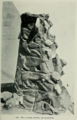
- Cultic site with massebot
Cultic remains discovered in the northern part of the tell were a row of ten large
Late Bronze Age
In the Late Bronze Age (second half of the 2nd millennium BCE) a new city wall, 4 m (13 ft) thick, was erected outside the earlier one.[18] It is a very rare example of Late Bronze Age fortifications in the country, witness for the elevated political status of Gezer in southern Canaan during Egyptian rule.[citation needed]
Thutmosid Period
| |||||||||||||
| ḳꜣḏjr or ḳꜣḏꜣꜣr[25][26] in hieroglyphs | |||||||||||||
|---|---|---|---|---|---|---|---|---|---|---|---|---|---|
| Era: New Kingdom (1550–1069 BC) | |||||||||||||
The Canaanite city was destroyed in a fire, presumably in the wake of a campaign by the Egyptian pharaoh Thutmose III (ruled 1479–1425 BC). The oldest known historical reference to the city is to be found on an inscription of conquered sites at Thutmose's temple at Karnak.[25] A destruction layer from this event was found in all excavated areas of the tell.[15]
Amarna Period
The Tell Amarna letters, dating from the 14th century BCE, include ten letters from the kings of Gezer swearing loyalty to the Egyptian pharaoh.[27] The city-state of Gezer (named Gazru in Babylonian) was ruled by at least three leaders during the 20-year period covered by the Amarna letters.[4] Discoveries of several pottery vessels, a cache of cylinder seals and a large scarab with the cartouche of Egyptian pharaoh Amenhotep III attest to the existence of a city at Gezer's location in the 14th century BCE—one that was apparently destroyed in the next century[28]—and suggest that the city was inhabited by Canaanites with strong ties to Egypt.[29]
In the 14th century BCE, a palace was constructed on the high western part of the tell, the city's acropolis.[citation needed] Archaeologists also discovered remains of what might have been the Egyptian governor's residence from the same period in the northern part of the tell.[citation needed]
Ramesside Period
In the late reign of Ramesses II, climate became drier and colder causing turmoil in the Mediterranean from around 1250 BC, eventually leading to the Late Bronze collapse. The death of Ramesses II caused cities in Canaan to rebel to become independent. Merneptah of Egypt, who succeeded Ramesses II, had to regain control and boasted about his capture of Gezer. A massive fiery destruction seems to support this in excavations done by Prof. Steven Ortiz.[30][31]
Toward the end of the Bronze Age, the city declined and its population diminished.[citation needed]
Iron Age

In 12th–11th centuries BCE, a large building with many rooms and courtyards was situated on the acropolis. Grinding stones and grains of wheat found among the sherds indicate that it was a granary. Local and Philistine vessels attest to a mixed Canaanite/Philistine population.[citation needed] The 10th century BCE seems to have been a period of notable urban development for the city until it became destroyed in the third quarter of that century, probably as a result of Shoshenq I's campaign in Canaan at that time.[32]
| Siege of Gezer | |||||||
|---|---|---|---|---|---|---|---|
| |||||||
| Belligerents | |||||||
| Egypt | Philistines | ||||||
| Commanders and leaders | |||||||
| Siamun (?) | Unknown | ||||||
| Strength | |||||||
| Unknown | Unknown | ||||||
| Casualties and losses | |||||||
| Unknown | Many killed | ||||||
Israelite city gate, wall
On the southern slope about 200 meters east of the gate from the Middle Bronze Age IIB, there is what is now known as the "Solomon Gate". This area was excavated at the beginning of the 20th century by Macalister, who defined the remains discovered there as a "Maccabean citadel" from the second century BCE, because on one of the stones a curse against Simon was found engraved in Greek (Macalister 1912, vol. I: 209–23; 236–56).
After the discovery of identical gates from the time of King Solomon in
Tiglath-Pileser III and the Neo-Assyrian period
The Neo-Assyrian king Tiglath-Pileser III put Gezer under siege between the years 734 and 732 BC.[38] The city was probably captured by the Assyrians at the end of the campaign of Tiglath-Pileser III to Canaan.[39] At any rate, a fiery destruction so severe befell the city at this time, insofar that it reduced the upper two courses of stone in the inner casemate wall to powdery lime.[40] A reference to Gezer's destruction appears in a cuneiform relief from the 8th-century BCE royal palace of Tiglath-Pileser III at Nimrud.[40] The city inscribed on the relief is called 'Gazru'.[15]
Hellenistic period
Stamped
According to the book of 1 Maccabees, Simon Thassi captured Gazara and expelled the population during the Maccabean Revolt. He then brought in new settlers of devout Jews and fortified it, making it part of the Hasmonean kingdom.[42] Gezer became known as Gazara in the Hellenistic period and became an important city for the Hasmonean rulers.[43][44][45]
Notwithstanding Simon's capture of Gezer in circa 142 BCE, Josephus alludes to the fact that Gezer returned under Seleucid control in the days of Antiochus VII Sidetes and during the high-priesthood of Simon's son, John Hyrcanus.[46]
Josephus, in both his Antiquities (12.7.4.; 13.6.7.; 13.9.2.) and in the Jewish War (1.2.2.), cites the Book of Maccabees as his primary source for these events and retains the Greek form of the name Gazara (Greek: Γάζαρά), meaning, Gezer.
Elsewhere, Josephus (
Roman and Byzantine periods
Gezer was sparsely populated during Roman times and later times, as other regional population centers took its place.[1] Archaeological finds attesting to the Hellenistic and early Roman periods include two bath houses discovered in situ, as well as a number of ritual baths (mikveh) and rock tombs.[48][a] The site continued to be occupied after the destruction of the Second Temple, but was gradually abandoned during the late Roman-early Byzantine period.[48]
Crusader period
In 1177, the plains around Gezer were the site of the
Early modern and modern periods
R.A. Stewart Macalister who excavated the ruin in the years 1902–1905 and 1907–1909 has noted that around the year 1869 the mound and other parts of the lands of the village of Abû Shûsheh were acquired by Messrs. Bergheim, who had been bankers in Jerusalem. Their acquisition of these lands would prove "a fortunate circumstance" for the excavator, as the site was later put at the disposal of the Palestine Exploration Fund.[51]
Archaeological highlights
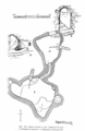
Canaanite water system


A large Canaanite (Bronze Age) water system comprising a tunnel going down to a spring, similar to those found in Jerusalem, Tel Hazor and Tel Megiddo, was first excavated by Macalister and was re-excavated as part of the 2006–2017 campaigns of the Tel Gezer Excavation and Publication Project.[52]
In 2010 a team from the New Orleans Baptist Theological Seminary ("NOBTS"), in partnership with the Israeli Parks Authority and the Israeli Antiquities Authority, launched an effort to clear a massive water tunnel, discovered first by Macalister over a hundred years earlier.[53] Macalister never fully excavated the tunnel because a strong storm blew debris back into the tunnel and he considered it too expensive and time consuming to re-excavate the site.[54][55]
In 2011 professor Dennis Cole, archaeologist Dan Warner and engineer Jim Parker from NOBTS, and Tsvika Tsuk from the Israeli Parks Authority, led another team in an attempt to finish the effort.[53] In just two years the teams removed approximately 299 tons of debris from the ancient water system.[53]
In 2012, the team uncovered a large sealed cavern about nine meters beyond the water pool and "Macalister's Causeway."
In 2013, the team began an effort to preserve the ancient Canaanite mudbrick gate and complex near the water system.
In the Water System: "Most of the first two weeks of the dig were spent searching for the bottom step and cleaning Macalister’s causeway. Tons of debris and rocks were removed in the process. When the bottom step was located and the causeway area clear, the team excavated three probes in the pool area. Each of the pool probes reached a depth of more than six feet before the end of the season and the bottom of the pool was discovered in only one probe (Eastern probe)—the one just below the bottom step of the water shaft."
The debris removal and excavation continued until the summer of 2017.[56]
Gezer calendar

One of the best-known finds is the "Gezer calendar". This is a plaque containing a text appearing to be either a schoolboy's memory exercises, or a text designated for organising the collection of taxes from farmers. Another possibility is that the text was a popular folk song, or child's song, listing the months of the year according to the agricultural seasons. It has proved to be of value by informing modern researchers of ancient Middle Eastern script and language, as well as the agricultural seasons.
Boundary stones

Thirteen boundary stones have been identified near the tell, distanced between less than 200 metres to almost 2 km from it, probably dating from the Late Hellenistic period (late second[57] – first century BCE), the most recent having been found by archaeologists from SWBTS in 2012.[58] See also Location.
There are only a few "lost" biblical cities that have been positively identified through inscriptions discovered by means of archaeological work (surveys or digs).
Ten of the thirteen inscriptions are bilingual,
Language: Hebrew or Aramaic
David M. Jacobson wrote that the inscriptions are in Hebrew and that this suggests a need for a closer look at their date.[58]
Other scholars are not convinced that the language of the inscriptions is Hebrew and not Aramaic, leaving both options as possible as is the case in the Corpus Inscriptionum Iudaeae/Palaestinae.[59]

Egyptian-era remains
In July 2017, archaeologists discovered skeletal remains of a family of three, one of the adults and a child wearing earrings, believed to have been killed during an Egyptian invasion in the 13th-century BCE.
Archaeological excavation history
Archaeological excavation at Gezer has been going on since the early 20th century, and it has become one of the most excavated sites in Israel. The site was identified with ancient Gezer by Charles Simon Clermont-Ganneau in 1871. R. A. Stewart Macalister excavated the site between 1902 and 1909 on behalf of the Palestine Exploration Fund.[61] Twentyone quarterly dig reports were published in the Palestine Exploration Quarterly.[62] Macalister recovered several artifacts and discovered several constructions and defenses. He also established Gezer's habitation strata, though due to poor stratigraphical methods, these were later found to be mostly incorrect (as well as many of his theories). In 1914 and 1921 Raymond-Charles Weill dug there, focusing mainly on the Bronze and Iron Age Tombs. Results were not published due the Weill's assistant Paule Zerlwer-Silberberg dying in a camp in occupied France and the excavation data was lost at that time.[63][64] Surprisingly, the master thesis of that assistant, about the dig, was recently discovered and was published in 2012.[65] Alan Rowe briefly visited the site in 1934. Between 1964 and 1974 G.E. Wright, William Dever and Joe Seger worked at Gezer on behalf of the Nelson Glueck School of Archaeology in the Hebrew Union College and Harvard University.[66][67][68][69][70][71][72] Dever worked there again in 1984 and 1990, with the Andrews University.[73]

Latest excavations and surveys (2006–2017)
Excavations were renewed in June 2006 by a consortium of institutions under the direction of Steve Ortiz of the Southwestern Baptist Theological Seminary (SWBTS) and Sam Wolff of the Israel Antiquities Authority (IAA). The Tel Gezer Excavation and Publication Project is a multi-disciplinary field project investigating the Iron Age history of Gezer. The effort completed in 2017.[74][75][76]
The first season of the Gezer excavations concluded successfully and revealed some interesting details. Among other things is a discovery of a thick destruction layer may be dated to the destruction at the hands of the Egyptians, which some associate with the biblical episode from 1 Kings 9:16: "Pharaoh, the king of Egypt, had attacked and captured Gezer, killing the Canaanite population and burning it down. He gave the city to his daughter as a wedding gift when she married Solomon."
In 2013, two separate archaeological survey-excavations were conducted at Tel Gezer, one by Tsvika Tsuk, Yohanan Hagai, and Daniel Warner, on behalf of the IAA,[77] and the other led by a team of archaeologists from the SWBTS and Andrews University's Institute of Archaeology.[78]
Gallery
-
-

-

-
-
-
-
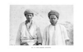
 Archaeologist or student with large, numerous massebot
 -
 Excavations at Tel Gezer
 -
 High place with "cup holders", cave mouth
 -
 Courses of stone in old tower at Gezer
 -
 recessed olive presses look similar to the cup holders at the same site, in a polka dot pattern
 -
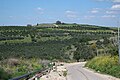 Approach to Tel Gezer (seen in distance)
 -
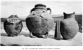
![Figurine discovered at Gezer.[79]](//upload.wikimedia.org/wikipedia/commons/thumb/6/6b/Teraphimandtongueofgold1.png/76px-Teraphimandtongueofgold1.png) Figurine discovered at Gezer.[79]
Figurine discovered at Gezer.[79]


![Figurine discovered at Gezer.[79]](/File:Teraphimandtongueofgold1.png)
See also
- Cities of the ancient Near East
- Archaeology of Israel
References
- ^ S2CID 165347088.
- ISBN 978-0-8028-3972-5.
- OCLC 937002750.
- ^ OCLC 745203905.
- JSTOR 3268603.
- ISBN 978-90-429-1798-9.
- ISBN 978-3-031-27330-8.
- ^ PMID 37967047.
- ^ Kitchen, K.A. (2003). On the Reliability of the Old Testament'. William B. Eerdmans Publishing. p. 109.
- ^ Kitchen, K.A. (2003). On the Reliability of the Old Testament'. William B. Eerdmans Publishing. pp. 109, 526.
- ^ Kitchen, K.A. (2003). On the Reliability of the Old Testament'. William B. Eerdmans Publishing. pp. 109–10.
- ISBN 978-1-84127-021-0.
- JSTOR 43855662.
- ^ Tel Gezer, Israel Antiquities Authority
- ^ a b c d Gibson, Shimon (2007). «Gezer». Encyclopedia Judaica (2nd ed.). 22 Nov. 2023 <https://www.encyclopedia.com>.
- ^ a b "Gezer – Ancient Importance to Israel". Allaboutarchaeology.org. Archived from the original on 8 February 2015. Retrieved 2 January 2015.
- ^ OCLC 745203905.
- ^ OCLC 1424889375.
- ^ Tel Gezer (Tel el-Jazari) Ancient Village or Settlement, The Megalithic Portal
- ^ OCLC 745203905.
Fortifications of the Middle Bronze Age IIB and of the Late Bronze Age are visible on the southern slope of the mound. The gate is typical of the Middle Bronze Age IIB and similar ones have been discovered in many sites in the Land of Israel and in Syria. It consists of two large brick towers and between them there is a direct passage to the interior of the city, between three pairs of matching pillars.
- ^ Ussishkin, David (2006). "On the History of the High Place at Gezer". In Czerny E.; Hein I.; Hunger H.; Melman D.; Schwab A. (eds.). Studies in Honour of Manfred Bietak. Vol. II. Leuven: Peeters Publishers. pp. 411–416. Retrieved 30 May 2015.
- OCLC 1424889375.
- ^ "Gilat". The Nelson Glueck School of Biblical Archaeology. Retrieved 2 June 2020.
- ^ Dever, William G, "The Middle Bronze Age "High Place" at Gezer", Bulletin of the American Schools of Oriental Research, vol. 371, pp. 17-57, May 2014
- ^ a b Gauthier, Henri (1928). Dictionnaire des Noms Géographiques Contenus dans les Textes Hiéroglyphiques Vol. 5. p. 164.
- ^ Wallis Budge, E. A. (1920). An Egyptian hieroglyphic dictionary: with an index of English words, king list and geological list with indexes, list of hieroglyphic characters, coptic and semitic alphabets, etc. Vol II. John Murray. p. 1043.
- ISBN 0-8018-4251-4.
- ^ a b Philippe Bohstrom (2 July 2017). "First Discovery of Bodies in Biblical Gezer, From Fiery Destruction 3,200 Years Ago". Haaretz. Retrieved 30 May 2020.
- ^ Shapira, Ran (2013-10-24). "Hidden secret of Gezer: A pre-Solomonic city beneath the ruins". Haaretz. Archived from the original on 2013-11-27. Retrieved 2013-11-27.
{{cite news}}: CS1 maint: bot: original URL status unknown (link), Haaretz, published October 24, 2013, retrieved November 27, 2013. - ^ "First Discovery of Bodies in Biblical Gezer, from Fiery Destruction 3,200 Years Ago". Haaretz.
- S2CID 199253906.
- S2CID 236231928.
- JSTOR 27924728.
- ^ "Gezer". Encyclopædia Britannica. Retrieved 2 January 2015.
- JSTOR 1356977.
- ^ OCLC 745203905.
- JSTOR 1356977.
- ISBN 978-90-04-10426-6.
- JSTOR 43855634.
- ^ JSTOR 27925997.
- JSTOR 26595238.
- ^ 1 Maccabees 13:43–48
- .
- ^ The Excavation of Ancient Gezer
- JSTOR 27925781.
- ^ Josephus, Antiquities (13.9.2.; 13.259).
- ISBN 9781575060408. Retrieved 30 May 2020.
- ^ OCLC 745203905.
- JSTOR 26601667.
- ISBN 9781134598465. Retrieved 15 December 2017.
- OCLC 1424889375.
- ^ a b Amanda Borschel-Dan (19 July 2017). "Biblical account of Gezer's destruction gains ground with torched skeleton finds". Times of Israel. Retrieved 30 May 2020.
- ^ a b c nobts.edu[permanent dead link]
- ^ members.bib-arch.org
- ^ Gary D. Myers, Archaeological team moves 230 tons of Israel dig debris, baptistpress.com, USA, September 15, 2011
- ^ "NOBTS - Rampage".
- ^ ISSN 2042-7867. Retrieved 1 June 2020.
- ^ S2CID 161134724.
- ^ ISBN 978-3-11-054421-3. Retrieved 1 June 2020.
- ^ Paton, C. (5 July 2017). "Israel: Ancient Human Remains Discovered in Biblical City 3,200 Years After its Destruction by the Egyptians". Newsweek. Archived from the original on 14 June 2018. Retrieved 7 July 2017.
- ^ R. A. Stewart Macalister, "The Excavation of Gezer: 1902 - 1905 and 1907 - 1909", John Murray, Albemarle Street West, London, 1912, Volume 1: [1] Volume 2: [2] Volume 3: [3]
- ^ R. A. Stewart Macalister, Twenty-First Quarterly Report on the Excavation of Gezer, Palestine Exploration Quarterly, vol. 41, iss. 2, pp. 87-105, 1909
- ^ P. Silberberg-Zelwer, "Les fouilles Edmond de Rothschild" in Cahiers Juifs, no. 23, pp.472 – 476, June – July 1936
- ISBN 978-1841715698
- ^ Zerlwer-Silberberg, Paule, Les Fouilles de M. Raymond Weill à Tell-Gezer (1914 et 1924): Le mémoire perdu et retrouvé de Mme Silberberg-Zelwer (1892–1942). Publication de deux campagnes de fouilles archéologiques conduites par M. Raymond Weill à Tell Gezer (1913–1924). 1942. Jerusalem: Centre de recherché français à Jèrusalem., 2012
- ISBN 9780878203000
- ISBN 978-0878203024
- ISBN 978-9652222022
- ISBN 978-0878203048
- ^ Joe D Seger, "Gezer V : the field I caves", Jerusalem : Nelson Glueck School of Biblical Archaeology, 1988
- ISBN 978-1-57506-312-6
- ISBN 978-1-57506-268-6
- ^ Younker, R. W., "A Preliminary Report of the 1990 Season at Tel Gezer: Excavations of the “Outer Wall” and the “Solomonic” Gateway ( July 2 to August 10, 1990).”, Andrews University Seminary Studies, vol. 29, pp. 19–60, 1991
- ^ http://www.telgezer.com/gezer/assets/File/neareastarch%2075%201%200004%20(4).pdf Ortiz, Steven; Wolff, Samuel, "GUARDING THE BORDER TO JERUSALEM: The Iron Age City of Gezer", Near Eastern Archaeology; Chicago, vol. 75, iss. 1, pp. 4–19, Mar 2012
- ^ http://www.telgezer.com/gezer/assets/File/Gezer%202006-2015-Transformation%20of%20Border.pdf Oded Lipschitz and Aren Maeir (eds.), "Tel Gezer Excavations 2006-2015: The Transformation of a Border City in The Shephelah during the Iron Age: Recent Archaeological Studies.", Eisenbrauns, pp. 61–102, 2017
- ^ S. Ortiz, S. Wolff, G. Arbino, "Tel Gezer, 2006-2009."; in Hadashot Arkheologiyot: Excavations and Surveys in Israel 123, Israel Antiquities Authority 123 (2011)
- ^ Israel Antiquities Authority, Excavators and Excavations Permit for Year 2013, Survey Permit # A-6744
- ^ Israel Antiquities Authority, Excavators and Excavations Permit for Year 2013, Survey Permit # S-438
- ^ "Bible side-lights from the Mound of Gezer, a record of excavation and discovery in Palestine : Macalister, Robert Alexander Stewart, 1870-1950 : Free Download, Borrow, and Streaming : Internet Archive". Internet Archive. 2023-03-25. Retrieved 2024-01-17.
Notes
- ^ Some of the tomb types discovered in Gezer include Arcosolium and loculus tombs, of which there were five Arcosolium or recessed bench tombs, another five distinct simple double arcosolia type, and nine loculus or kokhim tombs. These are considered to date to the Hellenistic through Byzantine periods, during which periods they were most common.[49]
Further reading
- William G. Dever, Gezer Revisited: New Excavations of the Solomonic and Assyrian Period Defenses, The Biblical Archaeologist, Vol. 47, No. 4 (Dec., 1984), pp. 206–218
- Dever, William G., "Visiting the Real Gezer: A Reply to Israel Finkelstein", Journal of the Institute of Archaeology of Tel Aviv University, Volume 30, Number 2, September 2003, pp. 259–282(24)
- "Confronting the Past: Archaeological and Historical Essays on Ancient Israel", Seymour Gitin, (ed), Eisenbrauns, (January 2006), ISBN 978-1-57506-117-7
External links
 Media related to Gezer at Wikimedia Commons
- New Orleans Baptist Theological Seminary's Official Record of the Tel Gezer Excavation
- The Tel Gezer Excavation and Publication Project (as of 2021); see also 2010 version.
- Tel Gezer Excavation Ceramic Database
- . Encyclopædia Britannica. Vol. 10 (9th ed.). 1879.