
Ghatal (community development block)
Ghatal | |
|---|---|
Community development block | |
Ghatal | |
| Website | paschimmedinipur |
Ghatal is a
Geography
In Ghatal CD block the soil is fertile alluvial and the area is a flat deltaic country intersected by numerous rivers and water courses. It is a flood prone area and is affected by water logging in the rainy season. 95% of the cultivated area has alluvial soil and 5% has lateritic soil.[1]
Ghatal is located at 22°40′00″N 87°43′00″E / 22.666667°N 87.716667°E.
Ghatal CD block is bounded by Goghat I CD block, in Hooghly district, in the north, Khanakul I and Khanakul II CD blocks, in Hooghly district, in the east, Daspur I CD block in the south and Chandrakona I CD block in the west.
It is located 58 km from Midnapore, the district headquarters.
Ghatal CD block has an area of 216.05 km2. It has 1
Gram panchayats of Ghatal block/ panchayat samiti are: Ajabnagar I, Ajabnagar II, Birsingha, Dewanchak I, Dewanchak II, Irhpala, Mansuka I, Mansuka II, Mohanpur, Monoharpur I, Monoharpur II and Sultanpur.[4]
Notable people
Ishwar Chandra Vidyasagar, scholar, social reformer and a key figure of the Bengal Renaissance, was born at Birsingha, now in this CD block, on 26 September 1820.[5][6]
Demographics
Population
According to the
As per the 2001 census, Ghatal block had a total population of 190,705, out of which 96,605 were males and 94,100 were females. Ghatal block registered a population growth of 11.83 per cent during the 1991-2001 decade. Decadal growth for the combined Midnapore district was 14.87 per cent.[8] Decadal growth in West Bengal was 17.45 per cent.[9]
Large villages (with 4,000+ population) in Ghatal CD block are (2011 census figures in brackets): Sultanpur (4,206), Erpala (4,503), Mansukha (8,583), Dirghagram (4,513), Dwandipur (4,060), Radhanagar (5,827), Shilarajnagar (4,082), Pratappur (4,699), Ratneshwar Bati (4,176) and Gopmohal urf Manoharpur (7,010).[7]
Other villages in Ghatal CD block include (2011 census figures in brackets): Mohanpur (2,296), Ajabnagar (3,682), Birsingha (3,026), Dewanchak (536), Alui (1,627), Gangadaspur (365), Iswarpur (880), Jalshara (2,183), Lachhipur (854) and Radhanagar (5,827).[7]
Literacy
According to the 2011 census the total number of literate persons in Ghatal CD block was 157,301 (81.08% of the population over 6 years) out of which males numbered 88,481 (83.34% of the male population over 6 years) and females numbered 68,820 (73.33% of the female population over 6 years). The gender gap in literacy rates was 15.01%.[7]
See also – List of West Bengal districts ranked by literacy rate
| Literacy in CD Blocks of Paschim Medinipur district |
|---|
| Jhargram subdivision |
| Binpur I – 69.74% |
| Binpur II – 70.46% |
| Gopiballavpur I – 65.44% |
| Gopiballavpur II – 71.40% |
| Jamboni – 72.63% |
| Jhargram – 72.23% |
| Nayagram – 63.70% |
Sankrail – 73.35%
|
| Medinipur Sadar subdivision |
| Garhbeta I – 72.21% |
| Garhbeta II – 75.87% |
| Garhbeta III – 73.42% |
| Keshpur – 77.88% |
| Midnapore Sadar – 70.48% |
| Salboni – 74.87% |
| Ghatal subdivision |
| Chandrakona I – 78.93% |
| Chandrakona II – 75.96% |
| Daspur I – 83.99% |
| Daspur II – 85.62% |
| Ghatal – 81.08% |
| Kharagpur subdivision |
| Dantan I – 73.53% |
| Dantan II – 82.45% |
| Debra – 82.03% |
| Keshiari – 76.78% |
| Kharagpur I – 77.06% |
| Kharagpur II – 76.08% |
| Mohanpur – 80.51% |
| Narayangarh – 78.31% |
| Pingla – 83.57% |
| Sabang – 86.84% |
| Source: 2011 Census: CD Block Wise Primary Census Abstract Data |
Language and religion
In the 2011 census Hindus numbered 197,488 and formed 89.95% of the population in Ghatal CD block. Muslims numbered 21,450 and formed 9.77% of the population. Others numbered 617 and formed 0.28% of the population.[10] Others include Addi Bassi, Marang Boro, Santal, Saranath, Sari Dharma, Sarna, Alchchi, Bidin, Sant, Saevdharm, Seran, Saran, Sarin, Kheria,[11] Christians and other religious communities. In 2001, Hindus were 90.71% and Muslims 9.24% of the population respectively.[12]
At the time of the 2011 census, 98.59% of the population spoke Bengali and 1.38% Santali as their first language.[13]
BPL families
In Ghatal CD block 38.86% families were living
According to the District Human Development Report of Paschim Medinipur: The 29 CD blocks of the district were classified into four categories based on the poverty ratio. Nayagram, Binpur II and Jamboni CD blocks have very high poverty levels (above 60%). Kharagpur I, Kharagpur II, Sankrail, Garhbeta II, Pingla and Mohanpur CD blocks have high levels of poverty (50-60%), Jhargram, Midnapore Sadar, Dantan I, Gopiballavpur II, Binpur I, Dantan II, Keshiari, Chandrakona I, Gopiballavpur I, Chandrakona II, Narayangarh, Keshpur, Ghatal, Sabang, Garhbeta I, Salboni, Debra and Garhbeta III CD blocks have moderate levels of poverty (25-50%) and Daspur II and Daspur I CD blocks have low levels of poverty (below 25%).[14]
Economy
Infrastructure
139 or 80% of mouzas in Ghatal CD block were electrified by 31 March 2014.[15]
145 mouzas in Ghatal CD block had drinking water facilities in 2013-14. There were 231 fertiliser depots, 100 seed stores and 50
Agriculture
Persons engaged in agriculture
in Ghatal CD block
Although the Bargadari Act of 1950 recognised the rights of
In 2005-06 the nett cropped area in Ghatal CD block was 19,800 hectares, out of a geographical area of 23,901 hectares, and the area in which more than one crop was grown was 16,326 hectares.[17]
The extension of irrigation has played a role in growth of the predominantly agricultural economy.[18] In 2013-14, the total area irrigated in Ghatal CD block was 13,730 hectares, out of which 70 hectares were irrigated by canal water, 250 hectares by tank water, 11,400 hectares by deep tubewells, 305 hectares by shallow tubewells, 1,700 hectares by river lift irrigation and 5 hectares by other methods.[15]
In 2013-14, Ghatal CD block produced 17,577 tonnes of Aman paddy, the main winter crop, from 9,944 hectares, 4,536 tonnes of Aus paddy (summer crop) from 1,959 hectares, 37,964 tonnes of Boro paddy (spring crop) from 12,040 hectares, 16 tonnes of wheat from 7 hectares, 25,123 tonnes of jute from 1,448 hectares and 37,640 tonnes of potatoes from 2,289 hectares. It also produced pulses and oilseeds.[15]
Banking
In 2013-14, Ghatal CD block had offices of 11 commercial banks and 3
Transport
Ghatal CD block has 13 ferry services and 7 originating/ terminating bus routes. The nearest railway station is 45 km from the CD block headquarters.[15]
Education
In 2013-14, Ghatal CD block had 168 primary schools with 14,197 students, 5 middle schools with 278 students, 21 high schools with 8,235 students and 12 higher secondary schools with 9,953 students. Ghatal CD block had 375 institutions for special and non-formal education with 12,311 students.[15]
The United Nations Development Programme considers the combined primary and secondary enrolment ratio as the simple indicator of educational achievement of the children in the school going age. The infrastructure available is important. In Ghatal CD block out of the total 168 primary schools in 2008-2009, 100 had pucca buildings, 21 partially pucca, 2 kucha and 45 multiple type.[19]
Ghatal Rabindra Satabirshiki Mahavidyalaya, established in 1961, is the general degree college in this block.
Culture
The Ghatal CD block has several heritage temples.
-
 Jalshara: Baro chala Buro Shiva temple
 -
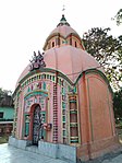
 Radhanagar: Pancha ratna Gopinath temple (in picture), laterite built in 1718, at Radhanagar and Pancha ratna Singhabahini temple at Nabagram, built in 1709, with exquisite terracotta carvings, both endangered.
 -
 Alui: Nava ratna Sridhara temple with rasmancha built in 1880 (in picture) and another nava ratna temple built in 1860 (renovated), both with terracotta carvings.
 -
 Iswarpur: Pancha ratna on a flat roof Sridharjiu temple.
 -
 Lachhipur: Nava ratna Sridharjiu temple, built in 1865, with large terracotta figures.


Healthcare
In 2014, Ghatal CD block had 1 block primary health centre and 2 primary health centres with total 26 beds and 7 doctors. It had 32 family welfare sub centres and 1 family welfare centre. 1,266 patients were treated indoor and 61,746 patients were treated outdoor in the hospitals, health centres and subcentres of the CD block.[15]
Vidyasagar Block Primary Health Centre, with 10 beds at Birsingha, is the major government medical facility in the Ghatal CD block. There are primary health centres at: Khasbarh (with 6 beds) and Natuk (with 10 beds).[20][21]
References
- ^ "District Human Development Report: Paschim Medinipur" (PDF). pages 4-5 (About Paschim Medinipur), page 26 (Predominant Soil), pages 265- 268 (Identification of Flood prone areas, Names of drought prone blocks). Development and Planning Department, Government of West Bengal, 2011. Archived from the original (PDF) on 29 March 2017. Retrieved 2 January 2017.
- ^ "District Statistical Handbook 2014 Paschim Medinipur". Tables 2.1, 2.2. Department of Planning and Statistics, Government of West Bengal. Retrieved 14 September 2020.
- ^ "District Census Handbook: Paschim Medinipur" (PDF). Map of Paschim Medinipur with CD Block HQs and Police Stations (on the fifth page). Directorate of Census Operations, West Bengal, 2011. Retrieved 20 November 2016.
- ^ "Directory of District, Subdivision, Panchayat Samiti/ Block and Gram Panchayats in West Bengal". Paschim Medinipur - Revised in March 2008. Panchayats and Rural Development Department, Government of West Bengal. Retrieved 1 August 2016.
- ^ Murshid, Ghulam. "Vidyasagar, Pundit Iswar Chandra". Banglapedia. Retrieved 24 July 2016.
- ^ "Ishwar Chandra Vidyasagar". www.whereincity.com. Retrieved 24 July 2016.
- ^ a b c d "C.D. block Wise Primary Census Abstract Data(PCA)". 2011 census: West Bengal – District-wise CD Blocks. Registrar General and Census Commissioner, India. Retrieved 3 May 2016.
- ^ "Provisional population totals, West Bengal, Table 4, (erstwhile) Medinipur District". Census of India 2001. Census Commission of India. Archived from the original on September 28, 2011. Retrieved 22 July 2016.
- ^ "Provisional Population Totals, West Bengal. Table 4". Census of India 2001. Census Commission of India. Archived from the original on 27 September 2007. Retrieved 17 July 2016.
- ^ a b "Table C-01 Population by Religion: West Bengal". censusindia.gov.in. Registrar General and Census Commissioner of India. 2011.
- ^ "ST-14 A Details Of Religions Shown Under 'Other Religions And Persuasions' In Main Table". West Bengal. Registrar General and Census Commissioner, India. Retrieved 29 July 2016.
- ^ "Table C01 Population by Religious Community: West Bengal". Registrar General and Census Commissioner of India. 2001.
- ^ a b "Table C-16 Population by Mother Tongue: West Bengal". www.censusindia.gov.in. Registrar General and Census Commissioner of India.
- ^ a b "District Human Development Report: Paschim Medinipur" (PDF). May 2011. Page 177. Development & Planning Department, Government of West Bengal. Archived from the original (PDF) on 29 March 2017. Retrieved 8 January 2017.
- ^ a b c d e f g h i "District Statistical Handbook 2014 Paschim Medinipur". Tables 2.1, 8.2, 16.1, 17.2, 18.2, 18.1, 20.1, 21.2, 4.4, 3.1, 3.3 – arranged as per use. Department of Planning and Statistics, Government of West Bengal. Retrieved 14 September 2020.
- ^ "District Human Development Report: South 24 Parganas". (1) Chapter 1.2, South 24 Parganas in Historical Perspective, pages 7-9 (2) Chapter 3.4, Land reforms, pages 32-33. Development & Planning Department, Government of West Bengal, 2009. Archived from the original on 5 October 2016. Retrieved 7 August 2016.
- ^ "District Human Development Report, Paschim Medinipur" (PDF). Table 2.4, Page 28. Development and Planning Department, Government of West Bengal, May 2011. Archived from the original (PDF) on 29 March 2017. Retrieved 2 January 2017.
- ^ "District Human Development Report: Paschim Medinipur" (PDF). Chapter V: Economic Livelihoods, pages 129-131. Development and Planning Department, Government of West Bengal, 2011. Archived from the original (PDF) on 29 March 2017. Retrieved 2 January 2017.
- ^ "District Human Development Report: Paschim Medinipur" (PDF). May 2011. Page: 60. Development & Planning Department, Government of West Bengal. Archived from the original (PDF) on 29 March 2017. Retrieved 31 July 2016.
- ^ "Health & Family Welfare Department" (PDF). Health Statistics – Block Primary Health Centres. Government of West Bengal. Retrieved 1 September 2020.
- ^ "Health & Family Welfare Department" (PDF). Health Statistics – Primary Health Centres. Government of West Bengal. Retrieved 1 September 2020.