
Glossop
Glossop
| ||
|---|---|---|
Shire county | ||
| Region | ||
| Country | England | |
| Sovereign state | United Kingdom | |
| Post town | GLOSSOP | |
| Postcode district | SK13 | |
| Dialling code | 01457 | |
| Police | Derbyshire | |
| Fire | Derbyshire | |
| Ambulance | North West | |
| UK Parliament | ||
Glossop is a
Historically, the name Glossop refers to the small hamlet that gave its name to an ancient parish recorded in the
Architecturally, the area is dominated by buildings constructed with the local sandstone; a number of these, including
History
Toponymy and definition
The name Glossop is thought to be of Anglo-Saxon origin, named during the Angles' settlement in the 7th century, and derived from Glott's Hop—where hop could mean a valley,[2] a small valley in a larger valley system,[3] or a piece of land enclosed by marshes[4] and Glott was probably a chieftain's name. Because of its size and location, Glossop had many definitions. The village of Glossop is now called Old Glossop. Howard Town and Milltown gained importance. They were named New Town and then Glossop. Local government reorganisations had caused the Glossopdale villages to be promoted to a municipal borough and then have that status removed. Land has been added to Glossop and other lands removed. From a small settlement it became an ancient parish, a manor, a borough and a township. Currently, two county divisions in High Peak Borough, Derbyshire, have Glossop as part of their names.[1]
Ancient
There is evidence of a Bronze Age burial site on Shire Hill (near Old Glossop) and other possibly prehistoric remains at Torside (on the slopes of Bleaklow). The Romans arrived in 78 AD. At that time, the area was within the territory of the Brigantes tribe, whose main base was in Yorkshire. In the late 1st century the Romans built a fort, Ardotalia, on high ground above the river in present-day Gamesley.[2] The site of this fort was rediscovered in 1771 by an amateur historian, John Watson. It subsequently acquired the name Melandra Castle. The extensive site has been excavated, revealing fort walls, a shrine and the fort headquarters. The area has been landscaped to provide parking and picnic areas.
Medieval
King William I awarded the manor of Glossop to William Peverel, who began construction of Glossop Castle, but the entire estate was later confiscated. In 1157 King Henry II gave the manor of Glossop to Basingwerk Abbey. They gained a market charter for Glossop in 1290,[5] and one for Charlesworth in 1328. In 1433, the monks leased all of Glossopdale to the Talbot family, later Earls of Shrewsbury. In 1494, an illegitimate son of the family, Dr John Talbot, was appointed vicar of Glossop. He founded a school, and paved the packhorse route over the moors; this is known as Doctor's Gate.[6]
At the
Industrial and civic history

The medieval economy was based on sheep pasture and the production of wool by farmers who were tenants of the Abbot of Basingwerk and later the Talbot family. During the Industrial Revolution of the 18th century Glossop became a centre for cotton spinning. A good transport network between Liverpool and Glossop brought in imported cotton which was spun by a labour force with wool spinning skills. The climate of Glossopdale provided abundant soft water that was used to power mills and finish the cloth, and also gave the humidity necessary to spin cotton under tension. Initial investment was provided by the Dukes of Norfolk. By 1740, cotton in an unspun form had been introduced to make fustians and lighter cloths.[7]
Mills
The first mills in Glossop were woollen mills. In 1774, Richard Arkwright opened a mill at Cromford. He developed the factory system and patented machines for spinning cotton and carding. In 1785, his patents expired and many people copied Arkwright's system and his patents, exemplified by the Derwent Valley Mills. By 1788 there were over 200 Arkwright-type mills in Britain.[8] At the same time there were 17 cotton mills in Derbyshire, principally in Glossop. By 1831 there were at least 30 mills in Glossopdale, none of which had more than 1,000 spindles. The mill owners were local men: the Wagstaffs and Hadfields were freeholders from Whitfield; the Shepleys, Shaws, Lees, Garlicks and Platts had farmed the dale. The Sidebottoms were from Hadfield, the Thornleys were carpenters and John Bennet and John Robinson were clothiers.[7]
The calico printing factory of Edmund Potter (located in Dinting Vale) in the 1850s printed 2½ million pieces of printed calico, of which 80% was for export. The paper industry was created by Edward Partington who, as Olive and Partington, bought the Turn Lee Mill in 1874 to produce high-quality paper from wood pulp by the sulphite method. He expanded rapidly with mills in Salford and Barrow-in-Furness. He merged with Kellner of Vienna and was created Lord Doverdale in 1917. He died in 1925; his factories in Charlestown created nearly 1,000 jobs.[7]
Religion and benevolence


Bernard Howard, 12th Duke of Norfolk, rebuilt the old parish church in 1831, built All Saints Roman Catholic chapel in 1836, improved the Hurst Reservoir in 1837, and built the Town Hall, whose foundation stone was laid on Coronation Day 1838. The
A two-storey Township Workhouse was built between 1832 and 1834 on Bute Street (grid reference SK043952). Its administration was taken over by Glossop Poor Law Union in December 1837. The workhouse buildings included a 40-bed infirmary, piggeries and casual wards for vagrants. The workhouse later became Glossop Public Assistance Institution and from 1948 the N.H.S. Shire Hill Hospital.[9]
The mill owners, Catholics, Anglican, Methodist and Unitarian, built reading rooms and chapels. They worked together and worshipped together with their workers. The Woods, Sidebottoms and Shepleys were Anglicans and hence Tory, and they dominated every vestry, which was the only form of local government before 1866. They built four churches St James's, Whitfield in 1846, St Andrew's, Hadfield in 1874, Holy Trinity, Dinting in 1875 and St Luke's, Glossop. Francis Sumner and the Ellisons and Norfolks were Catholic and built St Charles's, Hadfield and St Mary's, Glossop. The smaller mill owners were Dissenters and congregated at Littlemoor Independent Chapel built in Hadfield in 1811, but they later built a further eleven chapels.[7]
For decades there was rivalry between Edward Partington, his friend Herbert Rhodes, and the Woods and Sidebottoms. The Woods built the public baths and laid out the park. Partington built the library. Partington built the cricket pavilion, so Samuel Hill-Wood sponsored the football club that for one season, 1899–1900, played in League Division One. He and his descendants went on to be chairmen of the London club, Arsenal. He was MP for High Peak from 1910 to 1929. Edward's son, Oswald, was MP for High Peak from 1900 to 1910. Ann Kershaw Woods devoted herself to Anglican education and had schools built.[7]
Cotton famine and industrial relations
In 1851, 38% of the men and 27% of the women were employed in cotton; the only alternative employment was agriculture, building, or labouring on the railway. Consequently, the town was vulnerable to interruptions in the supply of cotton or the export trade. The American Civil War caused the cotton famine of 1861–64. The mill owners met together and put in place a relief programme through which they supplied food, clogs and coal to their employees. Howard increased the workforce on his estate, and public works (such as improving the domestic water supply) were undertaken. They provided unsecured loans to the workers until the cotton returned. The relationship between the owners and men was one of paternal benevolence. They lived in the same community and worshipped in the same churches. The mill owners were the local aldermen, the church elders and led the sports teams. In the Luddite and Chartist times and the period following Peterloo, Glossop was virtually unaffected, despite its proximity to Hyde, a radical hotbed. In the '4s 2d or swing strike' it was incomers from Ashton who stopped the Glossop mills. The rivalry in Glossop was not based on class but on religious groups.[7]
Modern (20th and 21st centuries)

The decline of cotton spinning has resulted in the closure of many of the town's mills. The Howard family sold the Glossop Estate in 1925 and donated large areas to the people of Glossop. Manor Park was the location of the family's manor house and gardens. The recession of 1929 hit Glossop very hard: in 1929 the unemployment rate was 14%, and in 1931 it was 55%. In Hadfield it reached 67%. National initiatives to improve housing and employment conditions largely failed, and mills fell empty and decayed. Unemployment remained at 36% in 1938. The Second World War changed this: military stores, metals, machine tools, munitions, rubber and essential industries moved into the empty factories and left Glossop with a more diverse range of industries.
In spite of the Barlow Report[10] and government intervention, no significant employer moved into Glossop.[7]
In 2006, High Peak Borough Council granted planning permission for a local foam factory to store up to 120 tonnes of toluene diisocyanate. Further permissions granted in 2010 increased the amount to 280 tonnes. As a result of this, a Detailed Emergency Planning Zone and Extended Area of Risk were created, which encompasses Dinting, Hadfield and Gamesley.
Plans

Glossop has been included as pilot in the Liveability scheme,
Governance

In the local government reorganisation of 1974 the Municipal Borough of Glossop was abolished, and since then the two levels of local government are Derbyshire County Council, based in Matlock, and High Peak Borough Council then based in Chapel-en-le-Frith.
Glossop was included in the "South East Lancashire Special Review Area" under the Local Government Act 1958, and the Redcliffe-Maud Report of 1969 recommended its inclusion in a South East Lancashire–North East Cheshire metropolitan area. Glossop was not ultimately included in the Greater Manchester area established by the Local Government Act 1972, with the residents voting to remain in Derbyshire in 1973.[13] The county council, originally based in Derby, moved to Matlock in the late 1950s to facilitate easier travelling to the county hall from the northern extremities such as Glossop and the High Peak.
For the county council, Glossop is split between the divisions of Glossop and Charlesworth (electing two councillors), and Etherow (electing one councillor). Etherow division contains Hadfield North, Hadfield South, Gamesley and the large and sparsely populated Tintwistle ward, which was formerly in Cheshire. These boundaries were set in 2013.
| Division | Holder | |
|---|---|---|
| Etherow | Becki Woods | |
| Glossop and Charlesworth | Damien Greenhalgh | |
| Glossop and Charlesworth | Jean Wharmby |
At the district level, that is High Peak Borough Council, Glossop comprises these wards: Dinting, Gamesley, Hadfield North, Hadfield South, Old Glossop, Padfield, Howard Town, Simmondley and Whitfield. St John's represents the rural area that was formerly Glossopdale RDC and lies within the National Park. These were the wards used in the 2001 Census.
| Ward | Holder | |
|---|---|---|
| Dinting | WHARMBY, Jean | |
| Gamesley | MCKEOWN, Anthony Edward | |
| Hadfield North | KELLY, Edward | |
| Hadfield South | SIDDALL, Edward | |
| Hadfield South | MCKEOWN, Robert Joseph | |
| Howard Town | ABBOTTS, Rachel GREENHALGH, Damien | |
| Old Glossop | DOUGLAS, Jamie HARDY, Paul | |
| Padfield | CROSS, Oliver | |
| Tintwistle | BAKER, Robert | |
| St. John's | WHARMBY, George | |
| Simmondley | GARDNER, Stewart | |
| Simmondley | HAKEN, John | |
| Whitfield | OAKLEY, Graham Nigel |
Glossop itself does not have a parish council, but Tintwistle and St John's are parished.
The Member of Parliament for the
| Constituency | Holder | |
|---|---|---|
| High Peak | Robert Largan |
Historic Glossop

Historically, the ancient parish of Glossop consisted of the ten townships of the manor: Glossop, Hadfield, Padfield, Dinting, Simmondley, Whitfield, Chunal, Charlesworth, Chisworth, Ludworth and nine more:
The Manor of Glossop was made up of the territory that includes Hadfield, Padfield, Dinting, Simmondley, Whitfield, Chunal, Charlesworth, Chisworth, Ludworth and the village of Glossop, now called Old Glossop.[1][18] It had an area of 11,308 acres (45.76 km2), of which more than 8,000 acres (32 km2) were classed as moorland.[16]

The Municipal Borough of Glossop (1866–1974) contained the land within two miles of the town hall in Howard Town and a sliver to the north bounded by the River Etherow, an area of 3,052 acres (12.35 km2). It is cited as an example of a 'millocracy' as two-thirds of the elected councillors were mill owners.[19] The remaining parishes of Charlesworth, Chisworth and Ludworth formed Glossopdale Rural District, which remained in existence until 1934 when the parishes were split, Ludworth going into Marple RDC, Chisworth and the greater part of Charlesworth joining Chapel en le Frith RDC and the smaller part—271 acres (1.1 km2)—joining Glossop.[20]
The present community of Glossop is centred on Howardtown.[21] It is served by the Glossopdale Area Forum[22] and the Glossop Town Partnership.[23] The previous hamlet of Glossop is now known as Old Glossop.
Geography
Glossop is at the north-western extreme of England's East Midlands region, 184 miles (296 km) north-west of London, 15 miles (24 km) east of the city of Manchester, 24 miles (38.6 km) west of the city of Sheffield and 48 miles (77.2 km) north of Derby. It nestles in the foothills of the Pennines, with Bleaklow to the north-east and Kinder Scout to the south. It lies on Glossop Brook, a tributary of the River Etherow, in the area of peat moorland commonly known as the Dark Peak. The moors, which rise to over 1,960 ft, are cut by many deep V-shaped valleys known as cloughs, each formed by a stream known as a brook. Shelf Brook passes through Old Glossop where it joins Hurst Brook to form Glossop Brook, which passes westward through Milltown, Howard Town and Dinting to the River Etherow, which in turn runs south to join the River Goyt at Marple Bridge. Two other notable brooks are Padfield Brook and Gnat Hole Brook.
Neighbouring towns and moors | |
|---|---|
Geology

Directly beneath Glossop lie areas of Carboniferous Millstone Grit, shales and sandstone. Glossop is on the edge of the Peak District Dome, at the southern edge of the Pennine anticline. The Variscan uplift has caused much faulting and Glossopdale was the product of glacial action in the last glaciation period that exploited the weakened rocks. The steep-sided valleys of the cloughs cause significant erosion and deposition. The layers of sandstone, mudstones and shale in the bedrock act as an aquifer to feed the springs. The valley bottoms have a thin deposit of boulder clay. The brooks are fed by the peaty soils of the moors thus are acid (pH5.5–7.0); this means the instream wildlife is dependent on food sources from outside the channel.[24]
Climate
Glossop experiences a
Demography
Glossop demographics were recorded as the following:[20]
| Year | 1801 | 1811 | 1821 | 1831 | 1839 | 1851 | 1861 | 1871 | 1881 | 1891 | |||
|---|---|---|---|---|---|---|---|---|---|---|---|---|---|
| Population Glossop | 3,625 | 4,012* | 6,212 | 9,631 | 14,577 | 19,587 | 21,000 | 20,673 | 19,574 | 22,416 | |||
| Glossop and Charlesworth | 2,759 | 4,012* | 5,135 | 7,897 | 12,569 | 17,454 | 19,126 | 18,508 | 21,393 | 23,493 | |||
| Source: Vision of Britain through Time Source: Small Town Politics, 1959, A. H. Birch. pub OUP * Data set includes Chisworth and Ludworth | |||||||||||||
| Year | 1901 | 1911 | 1921 | 1931 | 1939 | 1951 | 1961 | 1971 | 2001 | ||||
|---|---|---|---|---|---|---|---|---|---|---|---|---|---|
| Population | 21,520 | 21,688 | 20,531 | 19,509 | estimate 23,500 | 18,994 | 17,500 | 24,272 | 32,428 | ||||
| Source: A Vision of Britain through Time | |||||||||||||
Economy
Glossop was a product of the wealth of the cotton industry. Glossop's economy was linked closely with a spinning and weaving tradition that had evolved from developments in
The main street contains a variety of shops, restaurants and food outlets.
Glossop is located close to the border of the
Landmarks


- Wren Nest Mill
Wren Nest Mill on High Street West was built c. 1800–10, with further extensions in 1815 and 1818, the latter incorporating an octagonal tower.[25] The present building is a small part of the original complex, which in its heyday employed 1,400 workers operating 123,000 spindles and 2,541 looms. It ceased trading in 1955.[26] A major fire in 1996 destroyed half the mill. The remaining half has been redeveloped into flats and retail units.[27]
- Wood's Mill, Howardtown Mills, Milltown Mills
From a group of small mills at Bridge End, John Wood built a complex of mills. Bridge End Mill was originally built in 1782 as a fulling mill. Today one mill building is being restored, and the Milltown mills lie idle.[28]
- Town hall
Glossop Town Hall and Market Hall was designed in Italianate style by Sheffield architects Weightman and Hadfield. The foundation stone was laid on 28 June 1838, the Coronation Day of Queen Victoria. The buildings were opened on 10 July 1845. Cost of construction exceeded £8,500. The facilities included a lock-up with four cells heated by hot water.[16]
- Dinting Viaduct
The viaduct was built in 1845, and later reinforced with additional piers.[25] An accident occurred in 1855, when an MS&LR passenger train was stopped by signalling on the viaduct at night. Two men and a woman mistook the parapet of the viaduct for the station platform at Hadfield, alighted from the train and fell 75 feet to their deaths.[29]
- Parish Church of All Saints
The present-day (2008) fabric of the parish church of All Saints is mostly of the 20th century; very little remains of the previous churches on this site. The first mention of a church in Glossop is in the charter of 1157 conferring the manor of Glossop on Basingwerk Abbey. Although the dedication of the church to All Saints may indicate an Anglo-Saxon origin, no trace of such a church has been found. The first recorded vicar is William, of 1252. At this time the church was probably aisleless. It was altered in the 15th century when the nave was rebuilt with arcades, aisles and a still-extant (2008) arch at the east end of the north aisle. In 1554 a new and taller tower with a broach spire was built 3 feet west of the old tower, incorporating the east wall of the previous tower. The nave was completely rebuilt in 1831, with removal and replacement of much of the old fabric including the tracery of the aisle windows. The work was carried out by the firm of E. W. Drury of Sheffield, the cost far exceeding the initial estimate of £700. When the nave was rebuilt in 1914 it was discovered that the arch leading to the chancel had been partly made up of plaster, the wall supported by this arch had not been bonded into the existing chancel walls, and the "oak" roof bosses were also plaster. Between the pillars of the nave sleeper walls had been built to a higher level than the pillar bases. These walls appear to have been needed to counteract the effects on the church structure of a combination of excess drainage from the nearby hillside and the numerous burials inside the church. The pillars of the new nave of 1914 were superimposed on the bases of the old pillars, and the floor built up to cover the sleeper walls.
The tower and chancel were demolished and rebuilt in 1853–55, the new tower also having a broach spire. The chancel was again rebuilt in 1923, completing the architect C. M. Hadfield's plan of 1914.[30] The present church has a nave of 5 bays, 25 yards long by 16 yards wide, with north and south aisles, and a chancel of 14 yards by 7 yards with a north aisle dedicated as St Catherine's Chapel.[31]
- Open spaces
Two public open spaces in Glossop have been given the
-
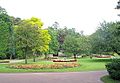 Manor Park's rose garden
 -
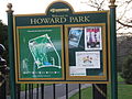 Notice board at the North Road entrance to Howard Park
 -
 Howard Park duck pond in winter
 -
 Norfolk Square, opposite the Town Hall


Transport
.jpg)

Early private horse-drawn buses were first provided by the Glossop Carriage Company Ltd, and an electric tramway connected Glossop with Hadfield between 1903 and 1927. Public transport in Glossop is now coordinated by Derbyshire County Council, with the exception of rail travel and some bus services being provided by Transport for Greater Manchester (TfGM).
Railway
A user group, the Friends of Glossop Station, are working to make the station more attractive and to encourage greater use of public transport.
Buses
There are regular bus services running to towns in Tameside, Buxton, New Mills, Whaley Bridge, the Hope Valley, Sheffield[36] and infrequent services to Holmfirth.
Bus services in Glossop are operated predominantly by
Roads
The main road through Glossop is the A57. To the west, this road (with the parallel M67 motorway) leads to Manchester, while Sheffield and the Hope Valley lie to the east, via the Snake Pass. The B6105 leads north then east, along the Woodhead Pass (A628) and eventually to the South Yorkshire town of Barnsley and the M1 motorway. Chapel-en-le-Frith, Buxton and Derby lie to the south, along the A624 and A6.
Leisure
The Peak District Boundary Walk runs along the eastern side of town through Charlestown and Old Glossop[37] and the Pennine Bridleway passes the western side of town around Gamesley and Hadfield.[38]
Schools and further education
| Primary schools |
| All Saints' RC Primary School |
| Charlesworth C of E School |
| Dinting C of E Primary School |
| Duke of Norfolk's C of E Primary School |
| Gamesley Community Primary School |
| Hadfield Infant School |
| Hadfield Nursery School |
| Padfield County Primary School |
| Simmondley Primary School |
| St Andrew's C of E Junior School |
| St Charles' RC Primary School |
| St James's C of E Primary School (formerly Whitfield Primary School) |
| St Luke's C of E Primary School |
| St Margaret's RC Primary School |
| St Mary's RC Primary School |
| Secondary |
| St Philip Howard Catholic Voluntary Academy[39] |
| Glossopdale School[40] |
| Adult learning |
| Glossopdale Adult Community Education |
| Glossopdale Sixth Form |
| Libraries |
| Glossop Library (Victoria Hall, Talbot Street, Glossop) |
| Hadfield Library (Station Rd, Hadfield) |
| Eric Read Community Library (Gamesley Primary School, Grindleford Grove, Gamesley) |
Sport
Glossop is the smallest town in England to have had a team in the top tier of the
The town also has a number of sports clubs, including tennis, golf, rugby union, cricket, bowls, running, cycling and sailing at
Culture
Performing arts
Partington Theatre is an amateur theatre with a 120-seat venue in the centre of the town. It runs six plays each season and was established in 1954. The building was started in 1914 and completed in 1917.
Glossop Improv is an improvisation group for adults, running drop-in workshops online and in-person.
Glossop & District Choral Society is a community choir founded in 1949 by Margaret Lomas.
Glossop Operatic and Dramatic Society was an amateur musical/drama society established in 1976.
Community events
Glossop
Glossop has a range of other cultural activities including Peak Film Society, a film club. Many other activities, including Glossop Folk Club take place at Glossop Labour Club. Also at Glossop Labour Club is the monthly Glossop Record Club, which holds vinyl listening sessions on the second Thursday of each month.[44]
Glossop has a thriving indoor and outdoor market where a wide selection of goods can be purchased. The indoor market is open every Thursday, Friday and Saturday, while the outdoor market is open every Friday and Saturday. The Outdoor Market is joined by the Local Produce Market on the 2nd Saturday of every month throughout the year.
The
Emergency service provision
Calls for service in the rural areas usually increase during the summer as the population is boosted by approximately twenty million visitors each year to the Peak District and its surrounds. Winter weather on the high ground around Glossop and Kinder Scout can also cause problems for traffic and residents.
Hospitals
State healthcare is provided for in Glossop and District by the NHS Derby and Derbyshire Integrated Care Board. Despite this, patients from the area use
Ambulance and paramedics
The North West Ambulance Service (NWAS) is the main ambulance service provider for the area, with an ambulance station based on Chapel Street. However, services are occasionally complimented and assisted by the East Midlands Ambulance Service (EMAS) in times of high demand, or to assist with a major incident.
Police and crime
When Glossop was granted Municipal Borough Status in 1867, the
Fire service
General
Mountain rescue
Specialised search and rescue services are provided by the volunteer Glossop Mountain Rescue Team, part of the Peak District Mountain Rescue Organisation. Their remit is to 'save lives in the mountains and moorlands'.[46]
Twin town
Bad Vilbel is a spa town in the Wetteraukreis district of Hesse, Germany, 5 miles (8 km) north-east of Frankfurt.
In 1985 the Glossop–Bad Vilbel Twinning Association was established. Its aims are:
To promote and foster friendship and understanding between the people of Glossop and district and those of Bad Vilbel and district in Germany. To encourage visits by individuals and groups to and from the linked towns, particularly by children and young people, and the development of personal contacts, and by doing so to broaden the mutual understanding of the cultural, recreational, educational and commercial activities of the linked towns.
Source: The Glossop-Bad Vilbel Twinning Association
In 1987 formal twinning ceremonies were held in both towns, with a tree being planted in Norfolk Square. The Twinning Association arranges for visitors to stay with families.[47] The two signatories of the charter were Catherine Holtom, the Mayor of High Peak, and Gunther Biwer, Bürgermeister of Bad Vilbel.
Literature and the media
Hilaire Belloc wrote about Glossop in a letter to a Miss Hamilton in 1909: "Do you know the filthy village of Glossop? It is inhabited entirely by savages. I tried every inn in the place and found each inn worse than the last. It stinks for miles. Rather than sleep in such a den I started walking back to Manchester with a huge bag...."[48]
Glossop is mentioned in the satirical book England, Their England by A. G. Macdonell. The town's fictional newspaper, the Glossop Evening Mail, is described as the lowest rung in the journalistic profession.
In 2013, Old Glossop was used for filming in the BBC drama series The Village, starring John Simm and Maxine Peake. The Parish Church of All Saints and the former Duke of Norfolk school building appeared in the series.
Local newspapers includes the Glossop Advertiser newspaper owned by the Manchester Evening News, the Glossop Chronicle, the Buxton Advertiser, the Glossop Gazette,
Regional TV news comes from Salford-based BBC North West and ITV Granada. Television signals are received from Winter Hill and the local relay transmitters. [49] [50]
The town’s local radio stations are BBC Radio Manchester, Glossop Community Radio and Greatest Hits Radio Derbyshire (High Peak), formerly known as High Peak Radio.
Notable persons
- Andy Cannon (born 1996) – professional footballer playing for Wrexham A.F.C., lived in Simmondley and attended St Philip Howard Catholic Voluntary Academy.
- Eileen Cooper (born 1953) – English contemporary painter and printmaker best known for her stylised paintings of women or couples, often featuring animals (particularly tigers).
- Nicholas Garlick (c. 1555 – 24 July 1588) – English priest, martyred in the reign of Queen Elizabeth I.
- Benjamin Charles Garside (born 1863) – Wisconsin machinist and Populist legislator.
- Gothic Revivalarchitect, born at Lees Hall.
- Head of the Home Civil Servicefrom 2014 to 2018. Lived on Spire Hollin.
- John Vernon Lord (born 1939) – illustrator and author of children's books, such as The Giant Jam Sandwich, and Professor of Illustration at the University of Brighton. His grandfather and father owned Lord's Café at 16 High Street West from 1901 to 1963.
- Hilary Mantel DBE (1952–2022) – British novelist, short story writer and critic.[51]
- Dan Money (born 1976) – British bobsleigher who represented Great Britain at the Vancouver 2010 Winter Olympics.
- Paul Raymond, born Geoffrey Anthony Quinn (15 November 1925 – 2 March 2008) – English strip-club owner, publisher of pornography and property developer, widely dubbed the "King of Soho". The outbreak of World War II prompted relocation to Glossop where he was educated by the Irish Christian Brothers.
- Frederick Rowbottom (16 January 1938 – 12 October 2009) – British logician and mathematician. In set theory, a Rowbottom Cardinal is named after him.
- Andy Wilman (b. 16 August 1962) – co-creator and producer, BBC Top Gear, born in Glossop.
- Manchester University.
See also
References
- ^ a b c d The Ancient Parish of Glossop Archived 29 May 2008 at the Wayback Machine Retrieved 18 June 2008
- ^ a b "Glossop | Peak District Towns and Villages | Staffordshire | Derbyshire | England | UK". Cressbrook.co.uk. Archived from the original on 21 August 2008. Retrieved 14 June 2008.
- ISBN 0-86023-484-3
- ^ Wilkinson, P. (November 1998), 'Finding Beowulf in Kent's landscape', British Archaeology, Council for British Archaeology, York, Issue 39 .
- ^ "The Domesday Book Online – Derbyshire F-R". Domesdaybook.co.uk.
- ^ a b Davies, Peggy (December 1999). Annals of Glossop. Glossop, Derbyshire: Glossop Heritage Centre. pp. 5, 6.
- ^ a b c d e f g h i Birch, A.H. (1959). "2". Small Town Politics, A Study of Political Life in Glossop. Oxford University Press. pp. 8–38.
- ^ Derwent Valley Mills Partnership (2000). "Nomination of the Derwent Valley Mills for inscription on the World Heritage List". Derwent Valley Mills Partnership: 28, 94–97.
{{cite journal}}: Cite journal requires|journal=(help) - ISBN 978-0-7524-4488-8
- ^ Royal Commission on the Distribution of the Industrial Population (the Barlow Commission),1943
- ^ "High Peak Borough Council: round five update". Idea.gov.uk. Archived from the original on 28 May 2008.
- ^ a b "Glossop Vision Links". High Peak Borough Council. Archived from the original on 29 May 2008. Retrieved 27 June 2008.
- ^ Sharpe, N. 2005. Glossop Remembered. Landmark Publishing: London.
- ^ "Derbyshire County Council election results". 3 May 2013. Archived from the original on 6 May 2013.
- ISBN 0-947964-26-6)
- ^ a b c Wilson, Neil (2003). "Glossop, Derbyshire:White's History, Gazetteer and Directory of the County of Derby, 1857". Archived from the original on 25 April 2009. Retrieved 22 June 2008.
- ^ Ayers, Barbarann (25 September 2007). "Topographical and Historical Account of Derbyshire (Magna Britannia Vol. 5) Glossop – by Daniel and Samuel Lysons, 1817". GENUKI. pp. 165, 166, 167, 168, 169. Retrieved 9 July 2008.
- ISBN 0-86023-484-3)
- ^ British Political History, 1867–1990: Democracy and Decline.Malcolm Pearce,
- ^ a b "Glossop MB through time. Census tables with data for the Local Government District". A vision of Britain through time.
- ^ Map showing Howard Town ward in its 2001 context Archived 22 June 2011 at the Wayback Machine. Retrieved 22 June 2008
- ^ High Peak District Council Area forums. Archived 6 July 2008 at the Wayback Machine Retrieved 21 June 2008
- ^ Glossop Town Partnership. Retrieved 21 June 2008
- ^ Radcliffe, Gemma (2004). "Management Plan for Glossop Brook". University of Manchester, Masters Thesis: 54, 55. Retrieved 10 July 2008.[permanent dead link]
- ^ ISBN 0-14-071008-6. Page 219.
- ISBN 0-7524-3883-2.
- ^ "Glossop VAHeritage". Glossop Victorian Architectural Heritage. Retrieved 4 August 2022.
- ^ Urqhart, Peter. "Explore Glossop Tours and Trails" (PDF). High Peak Borough Council. Archived from the original (PDF) on 11 March 2022. Retrieved 11 July 2008.
- ^ Rivington, F. & J., (1856) The Annual Register or a View of the History and Politics of the year 1855, Longman & Co. London. p. 149.
- ^ Pevsner, N.; Williamson, E. 1986, The Buildings of England:Derbyshire, 2nd. ed., Penguin, Middlesex. pp. 218–219.
- ^ Parochial Church Council (N.D.), A Guide to the Parish Church of All Saints, Glossop., British Publishing Company, Gloucester. pp 5–17.
- ^ "Howard Park, Glossop". High Peak Borough Council. Archived from the original on 24 November 2010. Retrieved 21 February 2011.
- ^ "Andrew Bingham MP visits Glossop Station". Andrewbingham.org.uk. 18 October 2011. Archived from the original on 20 March 2016.
- ^ "Friends of Glossop Station". Friends of Glossop Station.
- ^ "Glossop Advertiser". Menmedia.co.uk. 1 December 2011.
- ^ Cumber, Robert (16 September 2020). "New Sheffield-Manchester bus route across Peak District could be country's most picturesque". Sheffield Star. Retrieved 17 September 2020.
- ISBN 978-1909461536.
- ISBN 978-0319240670. Retrieved 31 July 2012.
- ^ St Philip Howard Catholic Voluntary Academy, retrieved 1 April 2016
- ^ "Home page". Glossopdale School. Retrieved 13 October 2018.
- ^ "Glossop North End History". Archived from the original on 12 October 2014. Retrieved 8 October 2014.
- ^ Glossop's Victorian weekend Archived 2 December 2008 at the Wayback Machine
- ^ statement from GALA Archived 6 January 2009 at the Wayback Machine
- ^ "Glossop Record Club" (blog). Retrieved 8 May 2018.
- ISBN 9781852493042.
- ^ "Glossop Mountain Rescue Team – whatwedo". Gmrt.org.uk. Archived from the original on 22 June 2008.
- ^ Glossop/Bad Vilbel Twinning Association Archived 16 June 2008 at the Wayback Machine
- ^ Speaight, R. 1957. Life of Hilaire Belloc. Farrar, Straus and Company, New York. cited in Smith, J.H. 2008. The WEA in Glossop 1907–2007. A Branch History. Workers' Educational Association, Glossop Branch. Glossop.
- ^ "Full Freeview on the Winter Hill (Bolton, England) transmitter". UK Free TV. Retrieved 7 November 2023.
- ^ "Freeview Light on the Glossop (Derbyshire, England) transmitter". UK Free TV. Retrieved 7 November 2023.
- ^ "Hilary Mantel, celebrated author of Wolf Hall, dies aged 70". The Guardian. 23 September 2022. Retrieved 23 September 2022.
External links
| International | |
|---|---|
| National | |
| Geographic | |