
Golden Chersonese
The Golden Chersonese or Golden Khersonese (
Name
The earliest references to a fabulous land of gold that could be interpreted as places in South East Asia may be found in Indian literature. In
Ptolemy's
Cartographic references

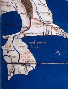
The Golden Chersonese appears in the map of
The Golden Chersonese is shown on the
Geographical locations
The names of various geographical features and settlements of the Golden Chersonese are given in
Rivers
The Ptolemy map shows three rivers which are joined together to form as their source a single river which does not actually exist. It has however been suggested that this might be an indication of the existence of an ancient transpeninsular route that linked Perak and Pahang, a short cut between the east and west coasts of the Malay Peninsula.[17]
- Khrysoanas river, meaning "River of Gold", proposed to be various rivers on the west coast, from the Trang River (in southern Thailand) or Lungu River, to the Perak River or the Bernam River, or further south the Muar River.[18][15]
- Palandas river, proposed to be Johor River by a number of scholars.
- Attabas river, which most authors agreed to be the Pahang River.[19]
Settlements
- Takola – a trading Rajendra Chola in his invasion of Srivijaya. These Indian sources indicate the existence of Takola from the 3rd to 11th century.[20]
- Konkonagara – a place near the Khrysoanas, with many scholars placing it in Phuket in Thailand. It is thought to be an Indian name, but it has also been proposed to be a hybrid of Malay and Sanskrit – kolong-kolong (or kekolong) and negara, meaning "the country of mines".[21] Some writers have suggested link with Gangga Negara.[22]
- Sabara or Sabana – the second emporion, variously proposed to be in Selangor or near Klang, or just south of Malacca, or south Johor, as well as Singapore.[23]
- Tharra – at least 10 different sets of coordinates have been given in different texts for this site, it is therefore difficult to pinpoint and there is no agreement in its identification.[24][25]
- Palanda – suggested to be Kota Tinggi by a few authors.
- Kalonka – various sites ranging from Chumphon Provincein southern Thailand to the Pahang River basin have been proposed.
- Kole polis – thought to be located on the north east coast of the Malay Peninsula, and suggested to be in Kelantan, or somewhere between Kemaman River and Kuantan.[26]
- Perimula - placed on the north east coast of the Malay Peninsula, suggestions include
Other features
- Cape Maleou-kolon – the name appears to refer to a "Malay Point", perhaps the south east corner of the Malay Peninsula. Some have identified it as Tanjung Penyabong or Tanjung Tenggaroh in Johor to Tanjung Gelang in Pahang.[28][29]
- The Perimulikos gulf – possibly the Songkhla have been suggested.[27]
See also
- Cathay
- Daqin
- Kattigara
- Suvarnabhumi
- Sino-Roman relations
- Serica
- "Great Golden Peninsula", another gold-related name used for Southeast Asia by Chinese emigrants in later times
- Greece–Indonesia relations
- Greece–Malaysia relations
- Mainland Southeast Asia
- History of Malaysia
- Malay Peninsula
References
- ^ a b c Wheatley 1961, pp. 138–159.
- ^ Wheatley 1961, pp. 177–184.
- .
- ^ May also be translated in forms such as the Isle of Chryse, Chryse Island, &c.
- ^ Gerini 1909, pp. 78–79.
- ^ H. Kern, "Java en het Goudeiland Volgens de Oudste Berichten", Bijdragen tot de Taal-, Land- en Volkenkunde van Nederlandsch-Indië, Volume 16, 1869, pp.638-648.[1]
- ^ Udai Prakash Arora, “Greek Geographers on the Indian Ocean and Southeast Asia”, in Chattopadhyaya, D. P. and Project of History of Indian Science, Philosophy, and Culture (eds.), History of Science, Philosophy and Culture in Indian Civilization, New Delhi, Oxford University Press, 1999, Vol.1, Pt.3, C.G. Pande (ed.), India's Interaction with Southeast Asia, Chapter 6, pp.184-185.
- ^ Wheatley 1961, pp. 128–129.
- ^ Gerini 1909, p. 78.
- ^ Wheatley 1961, pp. 131–136.
- ^ Choong En Han (March 16, 2014). "At least 5 gold mines in Malaysia are under foreign listed companies". Media Checker.
- ^ The Travels of Pedro Teixeira, tr. and annotated by W.F. Sinclair, London, Hakluyt Society, Series 2, Vol.9, 1902, p.10.
- ^ E.W. Dahlgren, “Were the Hawaiian Islands visited by the Spaniards before their Discovery by Captain Cook in 1778?”, Kungliga Svenska Vetenskapsakademiens Handlingar, Band 57. No.1, 1916-1917, pp.1-222, pp.47-48, 66.
- ^ Linehan 1951, pp. 86–98.
- ^ ISBN 9781317279037.
- ^ Mintz, Daniel. "Manuscript Tradition in Ptolemy's Geography". University of St Andrews.
- ISBN 9781461671992.
- ^ Linehan 1951, pp. 86, 88–91.
- ^ Linehan 1951, p. 88.
- ^ Wheatley 1961, pp. 268–272.
- ^ Linehan 1951, pp. 91–92.
- ISBN 9789674610234.
- ^ Wheatley 1961, pp. 151–152.
- ^ Linehan 1951, pp. 92–93.
- ^ Wheatley 1961, p. 156.
- ^ Wheatley 1961, pp. 152–153.
- ^ a b Wheatley 1961, pp. 154–155.
- ^ Linehan 1951, p. 97.
- ^ Wheatley 1961, pp. 153–154.
Bibliography
- Gerini, G. E. (1909). Researches on Ptolemy's geography of Eastern Asia (further India and Indo-Malay archipelago). Asiatic Society Monographs. Vol. 1. Royal Asiatic Society. pp. 77–111.
- Linehan, W. (1951). "The Identifications of Some of Ptolemy's Place Names in the Golden Khersonese" (PDF). Journal of the Malayan Branch of the Royal Asiatic Society. xxiv (III): 86–98. JSTOR 41503002. Archived from the original(PDF) on 25 February 2017.
- OCLC 504030596.