
Goliad, Texas
Goliad, Texas | ||
|---|---|---|
FIPS code 48-30080[4] | | |
| GNIS feature ID | 1358133[5] | |
| Website | www | |
Goliad (
History
Spain
In 1747, the Spanish government sent
With the conclusion of the
In early August 1812, during the
The area was invaded again in 1821. The United States and Spain had signed the Adams–Onís Treaty in 1819, which ceded all US territorial claims on the Texas area to Spain. On October 4, the Long Expedition (with 52 members) captured La Bahia. Four days later, Colonel Ignacio Pérez arrived with troops from Bexar, and Long surrendered.[19] By the end of 1821, Mexico had achieved its independence from Spain, and Texas became part of the newly created country.[20]
Mexico
In 1829, the name of the
On October 9, 1835, in the early days of the
The famous Mexican General Ignacio Zaragoza was born in Goliad in 1829. He commanded the forces resisting the French Army in the Battle of Puebla, now celebrated as Cinco de Mayo on May 5, 1862.[23]
The Texas gunfighter King Fisher lived for a time in Goliad before moving to Eagle Pass in Maverick County, Texas.
1902 tornado
The 1902 Goliad tornado devastated the town, killing 114 people, including Sheriff Robert Shaw, and injuring at least 225. It is tied for the deadliest tornado in Texas history and the 10th-deadliest in the United States.[24] Dr. Louis Warren Chilton, a young doctor whose wife was injured and whose daughter was lifted in the tornado funnel but survived, set up a temporary hospital and morgue in the courthouse. The Dr. L.W. and Martha E.S. Chilton House was built starting in June and included an underground shelter.[25]
Geography

Goliad is located near the center of Goliad County at 28°40′N 97°24′W / 28.667°N 97.400°W (28.669, –97.392).[26] U.S. Route 59 passes through the center of town as Pearl Street, leading northeast 26 miles (42 km) to Victoria and southwest 29 miles (47 km) to Beeville. U.S. Route 183 (Jefferson Street) crosses US 59 northeast of the original center of town; US 183 leads north 31 miles (50 km) to Cuero and south 26 miles (42 km) to Refugio. Goliad is 91 miles (146 km) southeast of San Antonio and 68 miles (109 km) north of Corpus Christi.
According to the United States Census Bureau, the city has a total area of 1.6 square miles (4.1 km2), of which 0.004 square miles (0.01 km2), or 0.28%, are water.[27] The San Antonio River flows from west to east along the southern border of the city; it is a tributary of the Guadalupe River, joining it just before their mouth at San Antonio Bay.
Climate
| Climate data for Goliad, Texas (1991–2020 normals, extremes 1937–2014) | |||||||||||||
|---|---|---|---|---|---|---|---|---|---|---|---|---|---|
| Month | Jan | Feb | Mar | Apr | May | Jun | Jul | Aug | Sep | Oct | Nov | Dec | Year |
| Record high °F (°C) | 90 (32) |
97 (36) |
99 (37) |
105 (41) |
102 (39) |
112 (44) |
112 (44) |
112 (44) |
111 (44) |
102 (39) |
96 (36) |
89 (32) |
112 (44) |
| Mean daily maximum °F (°C) | 65.6 (18.7) |
69.6 (20.9) |
75.1 (23.9) |
81.1 (27.3) |
86.8 (30.4) |
91.6 (33.1) |
94.7 (34.8) |
96.1 (35.6) |
90.9 (32.7) |
84.3 (29.1) |
74.7 (23.7) |
67.5 (19.7) |
81.5 (27.5) |
| Daily mean °F (°C) | 54.4 (12.4) |
58.3 (14.6) |
64.3 (17.9) |
70.7 (21.5) |
77.1 (25.1) |
82.0 (27.8) |
84.3 (29.1) |
85.0 (29.4) |
80.5 (26.9) |
72.6 (22.6) |
63.2 (17.3) |
56.1 (13.4) |
70.7 (21.5) |
| Mean daily minimum °F (°C) | 43.3 (6.3) |
47.0 (8.3) |
53.4 (11.9) |
60.4 (15.8) |
67.4 (19.7) |
72.5 (22.5) |
73.8 (23.2) |
73.8 (23.2) |
70.1 (21.2) |
60.9 (16.1) |
51.8 (11.0) |
44.7 (7.1) |
59.9 (15.5) |
| Record low °F (°C) | 7 (−14) |
13 (−11) |
20 (−7) |
32 (0) |
42 (6) |
55 (13) |
61 (16) |
61 (16) |
44 (7) |
23 (−5) |
20 (−7) |
8 (−13) |
7 (−14) |
| Average precipitation inches (mm) | 2.71 (69) |
1.73 (44) |
2.74 (70) |
2.67 (68) |
4.54 (115) |
3.90 (99) |
2.95 (75) |
3.41 (87) |
4.69 (119) |
3.41 (87) |
2.33 (59) |
2.13 (54) |
37.21 (945) |
| Average snowfall inches (cm) | 0.0 (0.0) |
0.0 (0.0) |
0.0 (0.0) |
0.0 (0.0) |
0.0 (0.0) |
0.0 (0.0) |
0.0 (0.0) |
0.0 (0.0) |
0.0 (0.0) |
0.0 (0.0) |
0.0 (0.0) |
0.0 (0.0) |
0.0 (0.0) |
| Average precipitation days (≥ 0.01 in) | 7.1 | 6.9 | 6.1 | 5.0 | 5.3 | 7.0 | 6.4 | 5.9 | 8.0 | 6.5 | 5.7 | 6.7 | 76.6 |
| Average snowy days (≥ 0.1 in) | 0.0 | 0.0 | 0.0 | 0.0 | 0.0 | 0.0 | 0.0 | 0.0 | 0.0 | 0.0 | 0.0 | 0.0 | 0.0 |
| Source: NOAA[28][29] | |||||||||||||
Demographics
| Census | Pop. | Note | %± |
|---|---|---|---|
| 1880 | 885 | — | |
| 1930 | 1,424 | — | |
| 1940 | 1,446 | 1.5% | |
| 1950 | 1,584 | 9.5% | |
| 1960 | 1,782 | 12.5% | |
| 1970 | 1,709 | −4.1% | |
| 1980 | 1,990 | 16.4% | |
| 1990 | 1,946 | −2.2% | |
| 2000 | 1,975 | 1.5% | |
| 2010 | 1,908 | −3.4% | |
| 2019 (est.) | 2,004 | [3] | 5.0% |
| U.S. Decennial Census[30] | |||
2020 census
| Race | Number | Percentage |
|---|---|---|
White (NH)
|
649 | 40.06% |
Black or African American (NH)
|
89 | 5.49% |
Alaska Native (NH)
|
5 | 0.31% |
| Asian (NH) | 6 | 0.37% |
| Some Other Race (NH) | 2 | 0.12% |
| Mixed/Multi-Racial (NH) | 41 | 2.53% |
| Hispanic or Latino | 828 | 51.11% |
| Total | 1,620 |
As of the 2020 United States census, there were 1,620 people, 713 households, and 420 families residing in the city.
2000 census
As of the
Of the 749 households, 33.9% had children under the age of 18 living with them, 51.7% were married couples living together, 12.8% had a female householder with no husband present, and 30.8% were not families. About 28.7% of all households were made up of individuals, and 15.8% had someone living alone who was 65 years of age or older. The average household size was 2.49 and the average family size was 3.04.
In the city, the population was distributed as 26.3% under the age of 18, 7.2% from 18 to 24, 24.4% from 25 to 44, 21.3% from 45 to 64, and 20.8% who were 65 years of age or older. The median age was 39 years. For every 100 females, there were 91.0 males. For every 100 females age 18 and over, there were 84.1 males.
The median income for a household in the city was $26,200, and for a family was $33,438. Males had a median income of $28,889 versus $20,167 for females. The
Education
The Goliad Independent School District [1] serves Goliad.
Attractions
- The motorsportsracing festival, used to be held at the Goliad Airport near Berclair, TX. After the US Navy reclaimed the airport as a training field, the festival has been held at an airport in Beeville, Texas.
- Goliad Market Day (held on the second Saturday of every month) is an event where produce, arts and crafts, and other retail items are sold.
- Schroeder Hall is one of Texas most legendary dance halls where legends like George Jones, Merle Haggard, Willie Nelson, Ray Price and many others often performed. The hall is still presenting some of the biggest names in country music today as it has for generations.
- Goliad Brewing Company Beer Garden Open to the public Friday 5pm–9pm and Saturday from 12–7pm
Notable people
- Bum Phillips, NFL head coach
- Ignacio Zaragoza, Mexican general
- Dalhart Windberg, artist
Gallery
-
 Presidio Nuestra Señora De Loreto De La Bahia
 -
 Nuestra Senora del Espiritu Santo de Zuniga Site
 -
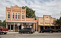
 Downtown Goliad, Texas
 -
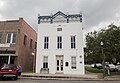 Masonic Lodge building in downtown
 -
 Goliad County Courthouse
 -
 Downtown Goliad, Texas
 -
 Goliad County Library
 -
 Downtown Goliad, Texas
 -
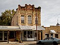
 Von Dohlen Building
 -
 Bergmann Building
 -
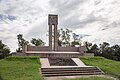 Goliad Massacre Monument
.jpg)
.jpg)
.jpg)
.jpg)
.jpg)
.jpg)
.jpg)
.jpg)
.jpg)
.jpg)
.jpg)
Climate
The climate in this area is characterized by hot, humid summers and generally mild to cool winters. According to the
See also
- List of geographic names derived from anagrams and ananyms
References
- ^ "City of Goliad Texas". City of Goliad Texas. Archived from the original on November 24, 2012. Retrieved October 19, 2012.
- ^ "2019 U.S. Gazetteer Files". United States Census Bureau. Retrieved August 7, 2020.
- ^ a b "Population and Housing Unit Estimates". United States Census Bureau. May 24, 2020. Retrieved May 27, 2020.
- ^ a b "U.S. Census website". United States Census Bureau. Retrieved January 31, 2008.
- ^ "US Board on Geographic Names". United States Geological Survey. October 25, 2007. Archived from the original on February 12, 2012. Retrieved January 31, 2008.
- ^ "Explore Census Data".
- ^ "Find a County". National Association of Counties. Archived from the original on May 31, 2011. Retrieved June 7, 2011.
- ^ Roell (1994), p. 13
- ^ Roell (1994), p. 14
- ^ Weber (1992), p. 198
- ^ Chipman (1992), p. 173
- ^ a b Roell (1994), p. 15
- ^ Roell (1994), p. 19
- ^ Almaráz (1971), p. 159
- ^ Almaráz (1971), p. 164
- ^ Roell (1994), p. 20
- ^ Almaráz (1971), p. 168
- ^ a b Roell (1994), p. 21
- ^ Roell (1994), p. 23
- ^ Weber (1992), p. 300
- ^ Jeri Robison Turner, "GOLIAD, TX," Handbook of Texas Online (https://tshaonline.org/handbook/online/articles/hjg05 Archived February 7, 2019, at the Wayback Machine), (Texas State Historical Association), accessed April 16, 2011.
- ^ Hardin (1994), p. 174
- ^ "ZARAGOZA, IGNACIO SEGUIN," Handbook of Texas Online (https://tshaonline.org/handbook/online/articles/fza04 Archived November 15, 2018, at the Wayback Machine) (Texas State Historical Association), accessed April 15, 2011.
- ^ Texas State Historical Commission, Goliad Tornado of 1902 Historical Marker, archived from the original on August 17, 2012, retrieved March 22, 2009
- ^ Mary Burns and Mary Dillman (February 1998). "National Register of Historic Places Registration: Dr. L.W. and Martha E.S. Chilton House". National Archives.
{{cite web}}: Missing or empty|url=(help) (accessible by searching within National Archives Catalog Archived January 3, 2017, at the Wayback Machine) - ^ "US Gazetteer files: 2010, 2000, and 1990". United States Census Bureau. February 12, 2011. Retrieved April 23, 2011.
- ^ "Geographic Identifiers: 2010 Demographic Profile Data (G001): Goliad city, Texas". American Factfinder. U.S. Census Bureau. Retrieved March 14, 2017.[dead link]
- ^ "NOWData - NOAA Online Weather Data". National Oceanic and Atmospheric Administration. Retrieved February 20, 2024.
- ^ "Summary of Monthly Normals 1991-2020". National Oceanic and Atmospheric Administration. Retrieved February 20, 2024.
- ^ "Census of Population and Housing". Census.gov. Retrieved June 4, 2015.
- ^ "Explore Census Data". data.census.gov. Retrieved May 21, 2022.
- ^ https://www.census.gov/ [not specific enough to verify]
- ^ "About the Hispanic Population and its Origin". www.census.gov. Retrieved May 18, 2022.
- ^ "Climate Summary for Goliad, Texas". Archived from the original on August 11, 2014. Retrieved February 3, 2014.
- Almaráz, Félix D. Jr. (1971), Tragic Cavalier: Governor Manuel Salcedo of Texas, 1808–1813 (2nd ed.), ISBN 0-89096-503-X
- Chipman, Donald E. (1992), Spanish Texas, 1519–1821, ISBN 0-292-77659-4
- OCLC 29704011
- Davenport, Harbert; Roell, Craig H. "GOLIAD MASSACRE". Handbook of Texas Online. Retrieved November 27, 2010.
- Roell, Craig H. (1994), Remember Goliad! A History of La Bahia, Fred Rider Cotten Popular History Series, Austin, TX: Texas State Historical Association, ISBN 0-87611-141-X
- ISBN 0-300-05198-0
External links
- City of Goliad official website
- [2] Handbook of Texas Online article
- The Texas Mile
Municipalities and communities of Goliad County, Texas, United States | ||
|---|---|---|
| City |  | |
| Unincorporated communities | ||
| ||
| International | |
|---|---|
| National | |
| Geographic | |