
Grand Turk Island
UTC-4) | |
| ISO code | TC |
|---|---|
Grand Turk is an island in the
The name comes from a species of
History
The Lucayan people were the indigenous people of the island, who called it Abawana, meaning "the First Small Land". The Spanish later called it Amuana.
Grand Turk was first colonised in 1681 by Bermudians, who set up the salt industry in the islands.
Grand Turk Lighthouse
Grand Turk Lighthouse was erected in 1852 near northern end of the island. The 60 ft (18 m) lighthouse was designed by Alexander Gordon and built by Chance Brothers in England. It was shipped in pieces and assembled on Grand Turk.[5][6]
-
 Grand Turk's lighthouse, on the northeastern tip of the island

Columbus landfall theory
Grand Turk has been put forward as the possible landfall island of Christopher Columbus during his first voyage to the New World in 1492.[7][8] San Salvador Island or Samana Cay in the Bahamas is traditionally identified with Guanahani, the site of Columbus' first landfall, but some believe that studies of Columbus' journals show that his descriptions of Guanahani much more closely fit Grand Turk than they do other candidates.[9] Magnetic variations that caused misreadings in Columbus' compasses demonstrate that several of the recorded moorings using a rope-secured anchor to a clear sandy bottom would not have been possible had Columbus sailed from the islands of the Bahamas.[10] In addition, the latitudes recorded in Columbus' diary place the landfall island at 90 nautical miles (100 mi; 170 km) from Hispaniola, too close for the Bahamas, but almost exactly the distance from Grand Turk.[10]
On the contrary, historian Gregory McIntosh has concluded that Grand Turk was not Guanahani but Babueca, an island separately discovered by Martín Alonso Pinzón in November - December 1492.[11]
U.S. Military presence
A U.S. Naval Facility (NAVFAC), the name given for a shore terminus of an offshore surveillance array of the Sound Surveillance System (SOSUS), was established on Grand Turk in 1954 as one of three additional Atlantic systems installed that year during the first phase of SOSUS installation. The facility was commissioned 23 October 1954 and was active until decommissioned 31 March 1980. The actual undersea surveillance mission of the system and shore facility remained classified through decommissioning.[12][13] The NAVFAC was located (21°30′43.6″N 71°07′57.7″W / 21.512111°N 71.132694°W) near the Grand Turk Lighthouse.
Missile Impact Location System
Grand Turk, located about 700 nmi (810 mi; 1,300 km) from
Other installations and events
From 1957 to 1959 USN Mobile Construction Battalion 7 constructed a LORAN Station on the island.[15]
In 1962, John Glenn's Friendship 7 Mercury spacecraft landed in the vicinity of Grand Turk off the southeast shoreline. A replica of the Friendship 7 is on display in Grand Turk at the entrance to the Grand Turk airport.[16]
In 1966 at least five Arcas (All-Purpose Rocket for Collecting Atmospheric Soundings) sounding rockets were launched from Grand Turk by the USA.[17]
-
 Looking north along Cockburn Town Beach, near the south end of Duke St.
 -
 Replica of the Friendship 7
 -
 Grand Turk as seen from space in 2009
 -
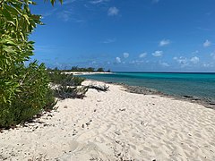 Looking east at Columbus Landfall Beach, near JAGS McCartney International Airport


See also
References
- ^ a b "Population 2012 census". Government of Turks and Caicos. Retrieved 15 May 2021.
- ^ Ferguson, James A.; Bounds, John H. "Turks and Caicos Islands". Encyclopædia Britannica. Archived from the original on 11 October 2008. Retrieved 2022-03-05.
- ^ About Grand Turk - Visit Turks and Caicos Islands
- ISBN 978-1-84162-268-2.
- ^ Rowlett, Russ. "Lighthouses of the Turks and Caicos Islands". The Lighthouse Directory. University of North Carolina at Chapel Hill. Retrieved 27 Oct 2017.
- ^ "TC Tourism". Retrieved 27 Oct 2017.
- ISBN 0-340-48794-1
- .
- ^ "Columbus Monuments Pages - Columbus' First Landfall".
- ^ a b Handy, Gemma (7 August 2016). "Following Columbus: The team trying to rewrite the explorer's route". BBC.com. BBC. Retrieved 7 August 2016.
- . Retrieved 20 August 2016.
- ^ "Integrated Undersea Surveillance System (IUSS) History 1950 - 2010". IUSS/CAESAR Alumni Association. Retrieved 13 September 2020.
- ^ Commander Undersea Surveillance. "Naval Facility Grand Turk — October 1954 - March 1980". U.S. Navy. Retrieved 13 September 2020.
- ^ Cone, Bruce E. (1 July 1976). The United States Air Force Eastern Test Range — Range Instrumentation Handbook (PDF). Patrick Air Force Base, Florida: Eastern Test Range, Directorate of Range Operations. pp. 1–1, 2-73–2-74. Archived (PDF) from the original on February 27, 2021. Retrieved 13 September 2020.
- ^ MCB 7 Cruise book 1957-59, Seabee Museum, Port Hueneme, Ca
- ^ "History of the Turks and Caicos Islands". Visit Turks & Caicos Islands. Retrieved 20 February 2015.
- ^ Frasketi Jr., Joseph J. "The Grand Turk Connection with". Joe Frasketi's Space and other Topical Covers. Retrieved 20 February 2015.
External links
- Grand Turk - Visit Turks and Caicos Islands
- Grandturk.tc
- Grand Turk Chamber of Commerce
 Grand Turk travel guide from Wikivoyage
| International | |
|---|---|
| Other | |