
Great Lakes megalopolis
Great Lakes megalopolis | |
|---|---|
 Chicago | |
.jpg) Toronto | |
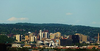
.jpg) Detroit-Windsor | |
| Countries |
|
| States | |
| Provinces |
|
| Largest city | Toronto (2,794,356)[1]
|
| Largest metropolitan area | Chicago metropolitan area (9,812,676) |
| Population | 59,100,000[2] |
The Great Lakes megalopolis consists of a bi-national group of metropolitan areas in North America largely in the Great Lakes region. It extends from the Midwestern United States in the south and west to western Pennsylvania and Western New York in the east and northward through Southern Ontario into southwestern Quebec in Canada. It is the most populated and largest megalopolis in North America.
At its most inclusive, in the United States the region cuts a wide swath from the twin cities of Minneapolis–Saint Paul in Minnesota in the west, south to St. Louis and Louisville, Kentucky, and east to Rochester, New York; in Canada, it continues northeasterly to Quebec City. This broader region had an estimated population of 59,144,461 as of 2011 and is projected to reach a population of about 65 million by 2025. Within this broad region, there is a core area of more continual urban development that includes Chicago, Milwaukee, Grand Rapids, South Bend, Detroit–Windsor, Columbus, Cleveland, Toledo, Pittsburgh, Buffalo, Rochester, Toronto, Ottawa, Montreal, and the metropolitan areas between these.
History of the concept


The region was partially outlined as an emergent megalopolis in the 1961 book Megalopolis: The Urbanized Northeastern Seaboard of the United States by French geographer Jean Gottmann. Gottmann envisaged the development of other megalopolises in the U.S.: from Boston to Washington, D.C., from Chicago to Pittsburgh, and from San Francisco to San Diego.
In 1965, futurist
In 2005, the Virginia Tech Metropolitan Institute's Beyond Megalopolis, an attempt to update Gottmann's work, outlined a similar "Midwest" megapolitan area as one of ten such areas in the United States (Canada is discussed tangentially).[7] Over 200 million tons of cargo are shipped annually through the Great Lakes.[8][9][10] The America 2050 project identified 11 Megaregions of the United States, including the Great Lakes Megalopolis.[11][A] The Canadian part of the region is also referred to as the Quebec City–Windsor Corridor, and the densest part in Southern Ontario has long been known as the Golden Horseshoe.[citation needed]
Governments
There are multiple government jurisdictions throughout the megalopolis. In addition to the federal governments of the United States and Canada, there are multiple
Economy
The five Great Lakes contain one-fifth of the world's surface fresh water and have a combined shoreline of 10,210 miles (17,017 km). About 200 million tons of cargo are shipped through the Great Lakes each year.[9][13][14]
The Great Lakes Cruising Coalition supports passenger ship cruises through a joint U.S-Canadian venture to Great Lakes Ports and the
Education
The Great Lakes Megalopolis is home to many prestigious institutions of higher education. Two founding members of the
The region also contains large multi-campus state


Major land and marine transportation corridors
The Great Lakes Megalopolis includes the following major inter-urban corridors that are provided with freeway and passenger rail service in both the core and fringe areas of the mega-region. Major waterways for shipping and cruising are also indicated where applicable. Amtrak in the United States and Via Rail in Canada offer rail passenger service, while most Class I freight rail services also connect these points. Major rail shipping services in both Canada and the United States is provided on tracks owned by Canadian National Railway and Canadian Pacific Railway.
Chicago-Minneapolis/St. Paul
This corridor occupies the northwestern fringe of the megalopolis. It occupies northern
Chicago-St. Louis
Chicago-Indianapolis-Cincinnati
Chicago-Buffalo-Rochester

Detroit-Chicago
Windsor-Quebec City
The
Secondary land or marine transportation corridors
Several corridors have interstate highways but no comprehensive passenger rail service. These highway routes pass through both core and fringe areas of the Great Lakes megalopolis. The upper Great lakes region has a marine corridor that connects Lakes Superior, Huron, and Michigan. However, this route does not include parallel Amtrak passenger rail or interstate highway service.
Kansas City-Pittsburgh
Detroit-Grand Rapids
Evansville-Indianapolis-Port Huron
Cincinnati-Saginaw
Duluth-Lake Huron
The waterway connecting Duluth, Minnesota, and western Lake Superior to points east and south includes the Soo Locks connecting to Lake Huron, then south to Port Huron MI/Sarnia ON or through the Straits of Mackinac to the metropolitan areas around Lake Michigan.
Selected American and Canadian population centers
| 2020 rank | City | Region | 2020 census[a] | 2010 census[b] | Change | Land area | 2020 population density |
|---|---|---|---|---|---|---|---|
| 1 | Toronto | 2,794,356 | 2,615,060 | +6.86% | 243.3 sq mi (630.1 km2) | 11,468/sq mi (4,428/km2) | |
| 2 | Chicago | 2,746,388 | 2,695,598 | +1.88% | 227.3 sq mi (588.7 km2) | 12,059/sq mi (4,656/km2) | |
| 3 | Montréal | 1,762,949 | 1,649,519 | +6.88% | 166.6 sq mi (431.5 km2) | 12,505/sq mi (4,828/km2) | |
| 4 | Ottawa | 1,017,449 | 883,391 | +15.18% | 1,077.3 sq mi (2,790.2 km2) | 950/sq mi (370/km2) | |
| 5 | Columbus | 905,748 | 787,033 | +15.08% | 226.3 sq mi (586.1 km2) | 4,110/sq mi (1,590/km2) | |
| 6 | Indianapolis | 887,642 | 820,445 | +8.19% | 361.6 sq mi (936.5 km2) | 2,455/sq mi (948/km2) | |
| 7 | Mississauga | 717,961 | 713,443 | +0.63% | 112.9 sq mi (292.4 km2) | 6,391/sq mi (2,468/km2) | |
| 8 | Brampton | 656,480 | 523,911 | +25.30% | 102.3 sq mi (265 km2) | 6,390/sq mi (2,470/km2) | |
| 9 | Detroit | 639,111 | 713,777 | −10.46% | 138.7 sq mi (359.2 km2) | 4,067/sq mi (1,570/km2) | |
| 10 | Louisville | 633,045 | 597,337 | +5.98% | 325.0 sq mi (841.7 km2) | 1,900/sq mi (730/km2) | |
| 11 | Milwaukee | 577,222 | 594,833 | −2.96% | 96.2 sq mi (249.2 km2) | 6,001/sq mi (2,317/km2) | |
| 12 | Hamilton | 569,353 | 519,949 | +9.50% | 431.8 sq mi (1,118.4 km2) | 1,319/sq mi (509/km2) | |
| 13 | Quebec City | 549,459 | 516,622 | +6.36% | 175.1 sq mi (453.5 km2) | 3,039/sq mi (1,173/km2) | |
| 14 | Kansas City | 508,090 | 459,787 | +10.51% | 314.7 sq mi (815 km2) | 1,614/sq mi (623/km2) | |
| 15 | Laval | 438,366 | 401,553 | +9.17% | 95.5 sq mi (247.3 km2) | 4,431/sq mi (1,711/km2) | |
| 16 | Minneapolis | 429,954 | 382,578 | +12.38% | 54 sq mi (140 km2) | 7,692/sq mi (2,970/km2) | |
| 17 | London | 422,324 | 366,151 | +15.34% | 162.4 sq mi (420.6 km2) | 2,365/sq mi (913/km2) | |
| 18 | Cleveland | 372,624 | 396,815 | −6.10% | 77.7 sq mi (201.2 km2) | 4,794/sq mi (1,851/km2) | |
| 19 | Markham | 338,503 | 301,709 | +12.20% | 81.4 sq mi (211 km2) | 4,156/sq mi (1,605/km2) | |
| 20 | Vaughan | 323,103 | 288,301 | +12.07% | 105.2 sq mi (272.5 km2) | 3,071/sq mi (1,186/km2) | |
| 21 | Saint Paul | 311,527 | 285,068 | +9.28% | 52 sq mi (135 km2) | 5,994/sq mi (2,314/km2) | |
| 22 | Cincinnati | 309,317 | 296,493 | +4.33% | 77.9 sq mi (201.8 km2) | 3,970/sq mi (1,530/km2) | |
| 23 | Pittsburgh | 302,971 | 305,704 | −0.89% | 55.4 sq mi (143.5 km2) | 5,471/sq mi (2,112/km2) | |
| 24 | St. Louis | 301,578 | 310,294 | −2.81% | 61.7 sq mi (160 km2) | 4,886/sq mi (1,886/km2) | |
| 25 | Gatineau | 291,041 | 265,349 | +9.68% | 132.4 sq mi (342.9 km2) | 2,004/sq mi (774/km2) | |
| 26 | Buffalo | 278,349 | 261,310 | +6.52% | 40.4 sq mi (104.6 km2) | 6,893/sq mi (2,661/km2) | |
| 27 | Toledo | 270,871 | 287,208 | −5.69% | 80.5 sq mi (208.5 km2) | 3,365/sq mi (1,299/km2) | |
| 28 | Madison | 269,840 | 233,309 | +15.66% | 79.6 sq mi (206 km2) | 3,391/sq mi (1,309/km2) | |
| 29 | Fort Wayne | 263,886 | 253,691 | +4.02% | 110.6 sq mi (286.5 km2) | 2,400/sq mi (930/km2) | |
| 30 | Kitchener | 256,885 | 219,153 | +17.22% | 52.8 sq mi (136.8 km2) | 4,900/sq mi (1,900/km2) | |
| 31 | Longueuil | 254,483 | 231,409 | +9.97% | 44.6 sq mi (115.5 km2) | 5,185/sq mi (2,002/km2) | |
| 32 | Windsor | 229,660 | 210,891 | +8.90% | 56.5 sq mi (146.3 km2) | 4,065/sq mi (1,570/km2) | |
| 33 | Oakville | 213,759 | 182,520 | +17.12% | 53.7 sq mi (139.1 km2) | 3,985/sq mi (1,539/km2) | |
| 34 | Rochester | 211,328 | 210,565 | +0.36% | 35.8 sq mi (92.7 km2) | 5,909/sq mi (2,281/km2) | |
| 35 | Richmond Hill | 202,022 | 185,541 | +8.88% | 38.9 sq mi (101 km2) | 5,191/sq mi (2,004/km2) | |
| 36 | Grand Rapids | 198,917 | 188,040 | +5.78% | 44.8 sq mi (116.0 km2) | 4,442/sq mi (1,715/km2) | |
| 37 | Overland Park | 197,238 | 173,372 | +13.77% | 75.2 sq mi (194.8 km2) | 2,600/sq mi (1,000/km2) | |
| 38 | Akron | 190,469 | 199,110 | −4.34% | 61.9 sq mi (160 km2) | 3,075/sq mi (1,187/km2) | |
| 39 | Burlington | 183,314 | 175,779 | +4.29% | 71.7 sq mi (185.7 km2) | 2,452/sq mi (947/km2) | |
| 40 | Aurora | 180,542 | 197,899 | −8.77% | 45 sq mi (116.5 km2) | 4,015/sq mi (1,550/km2) | |
| 41 | Oshawa | 175,383 | 149,607 | +17.23% | 56.3 sq mi (145.8 km2) | 2,660/sq mi (1,030/km2) | |
| 42 | Kansas City | 156,607 | 145,786 | +7.42% | 124.7 sq mi (323.0 km2) | 1,200/sq mi (460/km2) | |
| 43 | Joliet | 150,362 | 147,433 | +1.99% | 65.1 sq mi (168.6 km2) | 2,310/sq mi (890/km2) | |
| 44 | Lévis
|
149,683 | 137,218 | +9.08% | 173.4 sq mi (449.1 km2) | 827/sq mi (319/km2) | |
| 45 | Naperville | 149,540 | 141,853 | +5.42% | 39.1 sq mi (101.3 km2) | 3,824/sq mi (1,476/km2) | |
| 46 | Rockford | 148,655 | 152,871 | −2.76% | 64.9 sq mi (168.1 km2) | 2,290/sq mi (880/km2) | |
| 47 | Guelph | 143,740 | 121,688 | +18.12% | 33.7 sq mi (87.3 km2) | 4,258/sq mi (1,644/km2) | |
| 48 | Olathe | 141,290 | 125,872 | +12.25% | 61.6 sq mi (159.5 km2) | 2,300/sq mi (890/km2) | |
| 49 | Warren | 139,387 | 134,056 | +3.98% | 34.4 sq mi (89.1 km2) | 4,055/sq mi (1,566/km2) | |
| 50 | Trois-Rivières
|
139,163 | 129,886 | +7.14% | 111.7 sq mi (289.3 km2) | 1,203/sq mi (464/km2) | |
| 51 | Whitby | 138,501 | 122,022 | +13.50% | 56.6 sq mi (146.6 km2) | 2,445/sq mi (944/km2) | |
| 52 | Cambridge | 138,479 | 126,748 | +9.26% | 43.6 sq mi (112.9 km2) | 3,174/sq mi (1,225/km2) | |
| 53 | Dayton | 137,644 | 141,527 | −2.74% | 55.8 sq mi (144.5 km2) | 2,466/sq mi (952/km2) | |
| 54 | St. Catharines | 136,803 | 131,400 | +4.11% | 37.1 sq mi (96.1 km2) | 3,587/sq mi (1,385/km2) | |
| 55 | Sterling Heights | 134,386 | 129,699 | +3.61% | 36.5 sq mi (94.5 km2) | 3,686/sq mi (1,423/km2) | |
| 56 | Milton | 132,979 | 84,362 | +57.63% | 140.2 sq mi (363.1 km2) | 948/sq mi (366/km2) | |
| 57 | Kingston | 132,485 | 123,363 | +7.39% | 174.2 sq mi (451.2 km2) | 736/sq mi (284/km2) | |
| 58 | Ajax | 126,666 | 109,600 | +15.57% | 25.7 sq mi (66.6 km2) | 4,233/sq mi (1,634/km2) | |
| 59 | Ann Arbor | 123,851 | 113,934 | +8.70% | 28.2 sq mi (73.0 km2) | 4,388/sq mi (1,694/km2) | |
| 60 | Independence | 123,011 | 116,830 | +5.29% | 78 sq mi (202.0 km2) | 1,578/sq mi (609/km2) | |
| 61 | Waterloo | 121,436 | 98,780 | +22.94% | 24.7 sq mi (64.0 km2) | 4,910/sq mi (1,900/km2) | |
| 62 | Rochester | 121,395 | 106,796 | +13.67% | 55.6 sq mi (144.0 km2) | 2,184/sq mi (843/km2) | |
| 63 | Evansville | 118,414 | 117,429 | +0.84% | 47.4 sq mi (122.8 km2) | 2,477/sq mi (956/km2) | |
| 64 | Elgin | 114,797 | 108,188 | +6.11% | 38 sq mi (98.4 km2) | 3,019/sq mi (1,166/km2) | |
| 65 | Springfield | 114,394 | 116,250 | −1.60% | 61.2 sq mi (158.5 km2) | 1,870/sq mi (720/km2) | |
| 66 | Peoria | 113,150 | 115,007 | −1.61% | 48 sq mi (124.3 km2) | 2,359/sq mi (911/km2) | |
| 67 | Lansing | 112,644 | 114,297 | −1.45% | 39.1 sq mi (101.3 km2) | 2,878/sq mi (1,111/km2) | |
| 68 | Dearborn | 109,976 | 98,153 | +12.05% | 24.3 sq mi (62.9 km2) | 1,751/sq mi (676/km2) | |
| 69 | Green Bay | 107,395 | 104,057 | +3.21% | 45.5 sq mi (117.8 km2) | 2,299/sq mi (888/km2) | |
| 70 | Brantford
|
104,688 | 93,650 | +11.79% | 38.1 sq mi (98.7 km2) | 2,748/sq mi (1,061/km2) | |
| 71 | Chatham-Kent | 103,988 | 103,671 | +0.31% | 949 sq mi (2,458 km2) | 107/sq mi (41/km2) | |
| 72 | South Bend | 103,453 | 101,168 | +2.26% | 42 sq mi (108.8 km2) | 2,465/sq mi (952/km2) | |
| 73 | Davenport | 101,724 | 99,685 | +2.05% | 63.8 sq mi (165.2 km2) | 1,595/sq mi (616/km2) | |
| 74 | Lee's Summit | 101,108 | 91,364 | +10.67% | 63.9 sq mi (165.5 km2) | 1,582/sq mi (611/km2) | |
| 75 | Clinton Township | 100,513 | 96,796 | +3.84% | 281 sq mi (727.8 km2) | 3,445/sq mi (1,330/km2) |
See also
- Megalopolis (city type)
- Conference of Great Lakes and St. Lawrence Governors and Premiers
- Megaregions of the United States
- Great Lakes
- Quebec City – Windsor Corridor
- Conurbation
- Combined Statistical Area
- Census Metropolitan Area
- Rust Belt
Notes
- A. ^ a Various sources include Quebec City, Montreal and Ottawa in the Great Lakes Megalopolis, while excluding Minneapolis–Saint Paul, Kansas City, Cincinnati, Indianapolis, Louisville, and Columbus.[20] All these partial-consensus and non-consensus cities lie at the eastern, western, and southern fringes of the megalopolis.
Gallery
-
 Chicago (left) and Milwaukee (center)
 -
 Lakes Erie (right) and Ontario (left)
 -
 Indianapolis (left) to St. Louis (right)
 -
 Cleveland
 -
 Saint Paul
 -
 Fox Cities
 -
 Duluth


References
- ^ "Census Data 2021". Retrieved 2022-08-24.
- ^ "What is the Great Lakes Megalopolis?". Retrieved 2024-03-23.
- ^ "Megaregions - America 2050". Archived from the original on 2018-08-09. Retrieved 29 April 2023.
- ISBN 0-262-52237-3.
- ^ a b Cities: Capital for the New Megalopolis.Time magazine, November 4, 1966. Retrieved on July 16, 2010.
- ^ Doxiadis, Constantinos. (1970) The Great Lakes Megalopolis. Doxiadis Assoc.
- ^ "MegaCensusReport.indd" (PDF). America2050.org.
- ^ "About Our Great Lakes -Great Lakes Basin Facts- NOAA Great Lakes Environmental Research Lab (GLERL)". Glerl.noaa.gov. Archived from the original on 2012-03-08. Retrieved 2012-04-19.
- ^ a b "Economy of the Great Lakes Region". Great-lakes.net. 2012-04-13. Archived from the original on 2012-05-04. Retrieved 2012-04-19.
- ^ U.S Army Corps of Engineers (January 2009).Great Lakes Navigation System: Economic Strength to the Nation Archived 2011-07-18 at the Wayback Machine. Retrieved on April 11, 2011.
- ^ America 2050: Megaregions: Great Lakes. Archived 2020-02-20 at the Wayback Machine Regional Plan Association.
- ^ "Home - Great Lakes and St. Lawrence Governors and Premiers". Cglslgp.org.
- ^ Our lakes facts Archived 2012-03-08 at the Wayback Machine. NOAA. Retrieved July 25, 2011.
- ^ U.S Army Corps of Engineers (January 2009).Great Lakes Navigation System: Economic Strength to the Nation Archived 2011-07-18 at the Wayback Machine. Retrieved on July 25, 2011.
- ^ Great Lakes Cruising Coalition Retrieved on July 25, 2011.
- ^ "Forecasting 2020 U.S. County and MSA Populations" (PDF). Knowledge.wharton.upenn.edu. April 2016. Retrieved 27 May 2018.
- ^ "Academic Ranking of World Universities 2021". ShanghaiRanking Consultancy. Retrieved May 12, 2022.
- ^ "List of United States cities by population", Wikipedia, 2021-03-31, retrieved 2021-03-31
- ^ "List of the 100 largest municipalities in Canada by population", Wikipedia, 2021-02-05, retrieved 2021-03-31
- ^ Example: Great Lakes Megalopolis (PDF) (Map). The Center for Urban and Regional Studies, Youngstown State University. 2005. Archived from the original (PDF) on 2010-07-05.
Great Lakes of North America | |||||||||||||
|---|---|---|---|---|---|---|---|---|---|---|---|---|---|
| Main lakes | |||||||||||||
| Secondary lakes | |||||||||||||
| Bays and channels |
| ||||||||||||
| Waterways | |||||||||||||
| Islands | |||||||||||||
| Historic geology | |||||||||||||
| Organizations |
| ||||||||||||
| Related topics |
| ||||||||||||
