Greektown, Toronto
Greektown Γκρικτάουν ( Province | ||
|---|---|---|
| City | Toronto | |
Greektown, also known as The Danforth, is a commercial-residential
History

Prior to World War II, Toronto's nascent Greek population of about 3,000 was concentrated in the area bounded by
In the 1950s and 1960s, the Danforth saw an influx of European immigration (particularly from Italy and Greece), many of whom were fleeing political and economic unrest which culminated in the seizure of power by the

In 1993, the BIA Board of Management's lobbying of City Hall paid off, and the BIA was officially renamed "GreekTown on the Danforth". More recently, the area has experienced a wave of gentrification as higher-priced restaurants and bars have moved in, as well as a public square (at Logan Avenue by Alexander the Great Parkette). Greektown on the Danforth boasts one of the highest concentrations of restaurants per kilometre in the world.[citation needed] The neighbourhood is home to local raconteur Tom Petkos, and is mentioned in the Barenaked Ladies song, The Old Apartment, and by critically acclaimed author Joseph Assenza in his novel, "The History of John." Several scenes in the movie My Big Fat Greek Wedding were shot here, mentioned on free walking tours of the neighbourhood.

Some parts of Greektown are still dominated by Canadians of Greek descent (Greek-Canadians). As of the 2016 federal census, Greeks still constitute one of the most significant ethnic groups in the Toronto—Danforth ward (in which Greektown is located) by population, at 4.5% of the total ethnic origins reported. Greek is the third most-commonly reported mother tongue and home language in the ward, behind English and Cantonese[2]
On July 22, 2018, there was a mass shooting in Greektown that killed two and injured 13.[3]
Taste of the Danforth
The annual Taste of the Danforth is a large food festival held over 2½ days in mid-August. With no admission charge, the event welcomes all to enjoy modestly priced samples of cuisine available at restaurants along the stretch of Danforth Avenue from Broadview to Jones Avenues. Greek food prevails, but there are numerous options, including Thai, Chinese, Brazilian, Indian, Japanese and others. A midway offers games, children's rides, and interactive sports that include a climbing wall, street hockey and basketball. Several stages offer musical entertainment spanning the globe, with one stage emphasizing Greek performers of music, song, and dance. The event has grown substantially since the first Taste, in 1994, when 5,000 attended. In 2008, it drew over a million people,[4] moving to 1.5 million by 2015.
Street signs

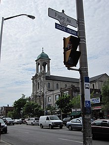
The street signs in Greektown are in both English and
- Carlaw Avenue – Οδος Καρλαω (Odos Karlaō)
- Danforth Avenue – Οδος Ντανφορθ (Odos Ntanphorth)
- Gough Avenue – Οδος Γκωφ (Odos Gkōph)
- Pape Avenue – Οδος Πεηπ (Odos Peīp)
See also
- Greek Canadians
- Greek Canadians in the Greater Toronto Area
References
- ^ Wencer, David. "Historicist: Greektown on the Danforth". Torontoist. Buzz Connected Media Inc. Retrieved 21 September 2022.
- ^ "Toronto-Danforth: Demographic Profiles". City of Toronto. Retrieved 21 September 2022.
- ^ "Three dead, including shooter, 12 injured in Toronto mass shooting".
- ^ "Our Story". Taste of the Danforth. Archived from the original on 2014-02-02. Retrieved 2014-01-29.
