
Grisons
Grisons
Graubünden | ||
|---|---|---|
| Canton of the Grisons Canton of Graubünden | ||
 Flag  Coat of arms | ||
 Location in Switzerland
Map of the Grisons Lowest point 260 m (853 ft): border to Ticino at San Vittore | | |
| Joined | 1803 | |
| Languages | German, Romansh, Italian | |
| Other languages | Lombard, Walser german | |
| Website | www | |
The Grisons (
The largest and easternmost canton of Switzerland, it is also one of the three large southern Alpine cantons, along with Valais and Ticino. It is the most diverse canton in terms of natural and cultural geography, as it encompasses both sides of the Alps and several natural and cultural regions. The diversity of the canton is often compared to that of Switzerland as a whole and warrants it the name of "Little Switzerland".[6][7] The Grisons is bordered by four cantons as well as Austria, Italy and Liechtenstein.
The state is the only trilingual canton of Switzerland.[8] It is also the only one where Romansh, Switzerland's fourth national language, has official status. Romansh language and culture is an important part of local identity.[9] In 2020 the canton had a population of 200,096.[2] It is the least densely populated canton of Switzerland. The only sizable city in the canton is Chur, as the majority of the population lives in mountainous areas, including some of the most remote valleys of the country. One of the birthplaces of winter sports, the canton is a major tourist destination year-round, including a large number of Alpine resort towns, notably Davos and St. Moritz. The canton is also renowned for its extensive narrow-gauge railway network, operated by the Rhaetian Railway, and linking the capital with most valleys of the Grisons.
Formerly occupied by the
Geography and climate

The Grisons is Switzerland's largest and at the same time easternmost canton. Its geography, essentially marked by the Alps, is complex and encompasses a wide range of climates and ecosystems. It is one of the three large southern Alpine cantons, along with Ticino and Valais, which include regions on the south side of the Alps. But in contrast to those (and all other cantons), it fully extends on both sides of the great Alpine barrier, from the northern plains at Maienfeld to the southern plains at Roveredo. However, a large portion of the canton is neither clearly north nor south of the Alps, it is the Engadin (the "garden of the Inn"), a large inner Alpine valley oriented towards eastern Europe. Therefore there are parts of this canton in four of the five drainage basins of the country. The north of the canton is drained by the Rhine (ending in the North Sea), the south by the Po and Adige through several affluents (Mediterranean Sea), and the Engadin by the Danube through the Inn (Black Sea).[10]
The Grisons lies fully within the Alps, with elevations above sea-level ranging from 260 to 4,049 metres (853 to 13,284 ft). It is
The regions on the north side of the Alps are all drained by the Rhine and form an intricate network of valleys. The Rhine is both one of the longest rivers within the canton and the only one flowing directly into a sea. The
The Engadin is entirely drained by the Inn and is the only valley in Switzerland in the Danube basin. The Inn is one of the longest rivers in the canton and forms an almost straight valley, from the
The valleys on the south side of the Alps are not contiguous to each other and form four distinct regions. The
Although no large bodies of water are found in the canton, numerous mountain lakes (above 800 m elevation) dot the landscape, some of them being used as reservoirs for hydroelectricity production. The largest natural lakes are
Unlike other large cantons, the Grisons includes very few cities. The largest (and capital city) is Chur. It is followed by Davos, Landquart, Domat/Ems and St. Moritz, which are, however, far less populated. The canton is particularly renowned for its numerous Alpine resort towns, notably two of the aforementioned ones (Davos and St. Moritz), but also Klosters, Arosa, Lenzerheide, Disentis, Flims, Pontresina and Scuol.[13]
The diversity of the climate of the Grisons is high and comparable to
-
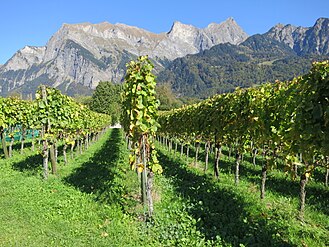 Lowlands: Vineyards of the Bündner Herrschaft, at the foot of the Falknis
 -
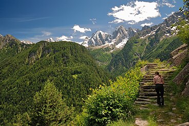 Montane zone: Val Bregaglia, at the foot of Piz Badile
 -
 Alpine zone: Val Frisal, at the foot ofPiz Durschin
 -
 Nival zone: Piz Bernina from Piz Morteratsch


The area of the Grisons is 7,105.2 square kilometres (2,743.3 sq mi), 19.2% larger than the canton of Bern, the second largest canton.[16] Only about a third of this is commonly regarded as productive land of which forests cover about a fifth of the total area.[16] The canton is almost entirely mountainous and it is the most sparsely populated region of the country. In its southeastern part lies the only official
The Grisons is sometimes included in the larger region of
History

The deep Alpine valleys of the present-day Grisons were originally settled by the
Most of the lands of the canton were once part of a Roman province called Raetia, which was established in 15 BC. The current capital of the Grisons, Chur, was known as Curia in Roman times. The area later was part of the lands of the diocese of Chur.
In 1367 the League of God's House (Cadi, Gottes Haus, Ca' di Dio) was founded to resist the rising power of the Bishop of Chur. This was followed by the establishment of the Grey League (Grauer Bund), sometimes called Oberbund, in 1395 in the Upper Rhine valley. The name Grey League is derived from the homespun grey clothes worn by the people and was used exclusively after 16 March 1424.[20] The name of this league later gave its name to the canton of the Grisons. A third league was established in 1436 by the people of ten bailiwicks in the former Toggenburg countship, as the dynasty of Toggenburg had become extinct. The league was called League of the Ten Jurisdictions (Zehngerichtebund).

The first step towards the canton of the Grisons was when the league of the Ten Jurisdictions allied with the League of God's House in 1450. In 1471 the two leagues allied with the Grey League. In 1497 and 1498 the Leagues
The last traces of the Bishop of Chur's jurisdiction were abolished in 1526. The
Between 1618 and 1639 it became a battleground between competing factions during the

In response, in February 1621, Jenatsch led a force of anti-Habsburg troops to attack
In 1623 the Leagues entered into an alliance with France, Savoy and Venice. Jürg Jenatsch and Ulysses von Salis used French money to hire an 8,000-man mercenary army and drive out the Austrians. The peace treaty of Monzon (5 March 1626) between France and Spain, confirmed the political and religious independence of the Valtellina. In 1627 the French withdrew from the Valtellina valley, which was then occupied by Papal troops. Starting in 1631 the League, under the French Duke Henri de Rohan, started to expel the Spaniards. However, Richelieu still did not want to hand the valley over to its residents. When it became clear that the French intended to remain permanently in the Leagues, but would not force the Valtellina to convert to Protestantism, Jürg Jenatsch (now a mercenary leader) converted in 1635 to the Catholic faith. In 1637, he rebelled and allied with Austria and Spain. His rebellion along with the rebellion of 31 other League officers forced the French to withdraw without a fight.[24][28] On 24 January 1639, Jürg Jenatsch was killed during Carnival by an unknown attacker who was dressed as a bear. The attacker may have been a son of Pompeius Planta[24] or an assassin hired by the local aristocracy.[28] According to legend he was killed by the same axe that he used on Pompeius Planta.[27] On 3 September 1639 the Leagues agreed with Spain to bring the Valtellina back under League sovereignty, but with the promise to respect the free exercise of the Catholic faith. Treaties with Austria in 1649 and 1652, brought the Müstair and Lower Engadine valleys back under the authority of the Three Leagues.[24]
In 1798, the lands of the canton of the Grisons became part of the
The arms of the three original leagues were combined into the modern
Government

The Grand Council (
The constitution of the Grisons, last revised on 14 September 2003, states in its
The constitution allows for the
Politics
Federal election results
| Percentage of the total vote per party in the canton in the Federal Elections 1971–2015[34] | ||||||||||||||
|---|---|---|---|---|---|---|---|---|---|---|---|---|---|---|
| Party | Ideology | 1971 | 1975 | 1979 | 1983 | 1987 | 1991 | 1995 | 1999 | 2003 | 2007 | 2011 | 2015 | |
FDP.The Liberalsa
|
Classical liberalism | 14.8 | 18.1 | 22.9 | 20.1 | 18.3 | 18.1 | 16.5 | 15.1 | 15.8 | 19.1 | 11.9 | 13.3 | |
| CVP/PDC/PPD/PCD | Christian democracy | 37.3 | 35.9 | 35.5 | 33.3 | 28.5 | 25.6 | 26.9 | 25.6 | 23.7 | 20.3 | 16.6 | 16.8 | |
| SP/PS | Social democracy | 13.9 | 15.2 | 20.5 | 24.6 | 19.5 | 21.2 | 21.6 | 26.6 | 24.9 | 23.7 | 15.6 | 17.6 | |
| SVP/UDC | National conservatism | 34.0 | 26.9 | 21.1 | 22.0 | 20.0 | 19.5 | 26.9 | 27.0 | 33.8 | 34.7 | 24.5 | 29.7 | |
| Ring of Independents | Social liberalism | * b | * | * | * | * | * | 1.1 | * | disbanded | disbanded | disbanded | disbanded | |
| CSP/PCS | Christian left | * | * | * | * | * | 6.9 | * | * | * | * | * | * | |
| GLP/PVL | Green liberalism | * | * | * | * | * | * | * | * | * | * | 8.3 | 7.9 | |
| BDP/PBD | Conservatism | * | * | * | * | * | * | * | * | * | * | 20.5 | 14.5 | |
| GPS/PES | Green politics | * | * | * | * | * | * | 3.5 | * | * | * | 2.2 | * | |
| FGA | Feminist | * | * | * | * | 6.0 | 4.3 | 1.9 | * | * | * | * | * | |
| SD/DS | Swiss nationalism | * | 3.5 | * | * | * | * | * | * | * | * | * | * | |
| EDU/UDF | Christian right | * | * | * | * | * | * | * | * | 1.9 | 1.6 | 0.5 | * | |
| Other | * | 0.3 | * | * | 7.7 | 4.4 | 1.7 | 5.8 | * | 0.6 | * | 0.2 | ||
| Voter participation % | 56.7 | 49.6 | 45.9 | 39.9 | 39.5 | 37.9 | 36.7 | 40.6 | 39.1 | 41.9 | 45.1 | 46.0 | ||
- ^a FDP before 2009, FDP.The Liberals after 2009
- ^b "*" indicates that the party was not on the ballot in this canton.
Political subdivisions
Regions
as of January 2017[35]
- Albula with capital Tiefencastel
- Bernina with capital Poschiavo
- Engiadina Bassa/Val Müstair with capital Scuol
- Imboden with capital Domat/Ems
- Landquart with capital Igis
- Maloja with capital Samedan
- Moesa with capital Roveredo
- Plessur with capital Chur
- Prättigau/Davos with capital Davos
- Surselva with capital Ilanz
- Viamala Region with capital Thusis
Municipalities
There are 114 municipalities in the canton (as of January 2016[update]).[36]
Demographics
.jpg)
The inhabitants of the Grisons are called Bündner or (rarely) Grisonians.[citation needed]
The population of the canton (as of 31 December 2020) is 200,096.
Languages

The Grisons is the only canton of Switzerland with three official languages: German (74.7%), Romansh (13.9%), and Italian (13.9%) with the remaining 13% speaking another language natively.[39][40]
| Year | Population | Romansh (%) | German (%) | Italian (%) |
|---|---|---|---|---|
| 1803 | 73,200[43] | 36,700 (~50%) | 26,500 (~36%) | 10,000 (~14%) |
| 1850 | 89,895 | 42,439 (47.2%) | 35,509 (39.5%) | 11,956 (13.3%) |
| 1880 | 93,864 | 37,794 (39.8%) | 43,664 (46.0%) | 12,976 (13.7%) |
| 1900 | 104,520 | 36,472 (34.9%) | 48,762 (46.7%) | 17,539 (16.8%) |
| 1920 | 119,854 | 39,127 (32.7%) | 61,379 (51.2%) | 17,674 (14.8%) |
| 1941 | 128,247 | 40,187 (31.3%) | 70,421 (54.9%) | 16,438 (12.8%) |
| 1950 | 137,100 | 40,109 (29.3%) | 77,096 (56.2%) | 18,079 (13.2%) |
| 1960 | 147,458 | 38,414 (26.1%) | 83,544 (56.7%) | 23,682 (16.1%) |
| 1970 | 162,086 | 37,878 (23.4%) | 93,359 (57.6%) | 25,575 (15.8%) |
| 1980 | 164,641 | 36,017 (21.9%) | 98,645 (59.9%) | 22,199 (13.5%) |
| 2000 | 187,058 | 27,038 (14.5%) | 127,755 (68.3%) | 19,106 (10.2%) |
| 2012 | 191,612 | 27,955 (15.2%) | 143,015 (74.6%) | 23,506 (12.0%) |
| 2015[44] | 193,662 | 29,826 (15.4%) | 142,378 (73.5%) | 25,033 (12.9%) |
| 2020 | 200,096 | 27,813 (13.9%) | 149,471 (74.7%) | 27,813 (13.9%) |
More speakers of the
Economy

Agriculture is still essential to keep remote valleys inhabited and cultivated, differing it from sheer wilderness. Agriculture is therefore supported by subsidies by the authorities both national and regional. Eight per cent of the population work in agriculture and forestry, where 50 per cent of the production is certified as organic. Agriculture includes forests and mountain pasturage in summer, particularly of cows, sheep and goats.[citation needed] Since wolf and bear have returned, the use of
24 per cent of the workforce are employed in industry whereas 68 per cent work in the service industry. The most industrialized region is naturally that of Chur. Ems-Chemie is based in Domat/Ems and is a major employer in the area.
The tourism industry is a major player and reaches a remarkable 14 per cent of the GDP. Tourism is concentrated around the towns of
Transport
As the canton extends on both sides of the great Alpine barrier, many important mountain passes are found there, particularly on the north-south axis. Transport has always been an important issue in the area; cart tracks from the Roman era were found on Julier Pass and Septimer Pass was rebuilt for cart use in 1387 and, although it later became unimportant, it is still in its 1800 form (for hikers only). Corniche paths were necessary for long stretches, and gorges such as the Viamala gave construction problems for any kind of transport. The first real roads of 3.7 m (4 yd) width were built across the Alps from around 1816, one of which is still in a very good historical condition[50] as this connection across Splügen Pass lost its importance after the opening of rail tunnels crossing the alps. The last valley to be connected to the road system in the Grisons was Avers, whose remote hamlet of Juf was only reached in 1897. After the Swiss Post expanded their Postal Bus transport services, the region's inhabitants became more used to motorized traffic.[51] In 1925, there were already 250 vehicles in service.[51] Eventually, the inhabitants of the Grisons gave up their resistance against individual motor traffic in 1926,[52] In 1967 opened San Bernardino road tunnel, built to host tourism traffic, is used also by heavy goods vehicles nowadays although not really suitable for them because of its ascent gradients. Most other passes have lost their importance for goods transport nowadays.
Unlike
Huge efforts ensure public transport to (nearly) every settlement by an integrated timetable of different transport companies. Even Juf, inhabited by some 30 people only but holding a
The Engadin valley has its own airport, Samedan Airport. It is the highest airport in Switzerland.
Culture

The Grisons is culturally the most diverse region of Switzerland. Its common denominator, however, is a strong mountain culture marked by life in isolated rural communities, notably depicted in Johanna Spyri's Heidi. Traditional customs include Alpine transhumance in spring and autumn, and the Chalandamarz at the end of winter.
The canton has a large concentration of medieval castles (and ruins). The most notable, in the Engadin, is that of

The gastronomy of the Grisons is mostly known for a dried-beef delicacy called Bündnerfleisch, often simply referred to as Grisons Meat. Other meat specialities include dried sausages (especially Salsiz, made of various meats), speck and ham. Cheeses produced in the Grisons are also numerous. Among notable dishes are the Capuns, predominantly made in the western part of the Grisons.[55] Capuns consist of hearty dumplings with pieces of meat wrapped in chard leaves, then gratinated in oven with cheese and cream. The Maluns are another well-known dish of the Grisons. They are made of boiled potatoes mixed with flour, then fried in butter. Maluns are typically served with a compote of apples and various other local products such as cheeses and meat specialities.[56] The Pizzoccheri are another dish, essentially eaten in the valley of Poschiavo. They consist of buckwheat noodles, cooked with potatoes, vegetables and cheese.[57] The emblematic dessert of the Grisons is the Bündner Nusstorte. It is essentially a shortcrust pastry filled with a mix of caramelized walnuts and honey. Another similar pastry, but containing chestnuts instead, the Torta di Castagne, is made in the southern valleys, especially in the Val Bregaglia.[58]
Wines are essentially produced in the Bündner Herrschaft. In the vineyards between Fläsch and Malans, 42 types of vines are found,
Radiotelevisiun Svizra Rumantscha is the Romansh-speaking division of the Swiss Broadcasting Corporation and focuses on the Grisons. Die Südostschweiz (in German) and La Quotidiana (Romansh) are some of the most important written media of the region.
Nature
The Grisons successfully reintroduced ibex in the early 20th century after it had all but died out from the Alps, except for an area in the Aosta Valley in Italy, Parco Nazionale Gran Paradiso.[60] Similarly, it reintroduced the bearded vulture and lynx in the 21st century, which had been extinguished, though the lynx remains rare.[61]
See also
Note
- ^ Names include:
- Puter: (Chantun) Grischun [ɡriˈʒum]
- Surmiran: (Cantun) Grischun [ɡriˈʒun]
- Sutsilvan: (Cantùn) Grischùn [ɡriˈʒuŋ, ɡriˈʒeu̯ŋ, ɡriˈʒœŋ]
- Rumantsch Grischun: (Chantun) Grischun;
- Italian: (Cantone dei) Grigioni [ɡriˈdʒoːni];
- Lombard: (Cantón) Griṡón [ɡriˈzoŋ];
- French: (Canton des) Grisons [ɡʁizɔ̃]. See also other names.
References
- ^ Arealstatistik Land Cover - Kantone und Grossregionen nach 6 Hauptbereichen accessed 27 October 2017
- ^ a b c "Ständige und nichtständige Wohnbevölkerung nach institutionellen Gliederungen, Geburtsort und Staatsangehörigkeit". bfs.admin.ch (in German). Swiss Federal Statistical Office - STAT-TAB. 31 December 2020. Retrieved 21 September 2021.
- ^ Statistik, Bundesamt für (21 January 2021). "Bruttoinlandsprodukt (BIP) nach Grossregion und Kanton - 2008-2018 | Tabelle". Bundesamt für Statistik (in German). Retrieved 1 July 2023.
- ISBN 978-0-521-15255-6.
- ^ "Welcome Bainvegni Benvenuti". Kanton Graubünden Chantun Grischun Cantone dei Grigioni. Retrieved 16 March 2021.
- ^ Benjamin R. Barber, The Death of Communal Liberty: A History of Freedom in a Swiss Mountain Canton, p. 13, Princeton University Press, 8 March 2015. ("Graubünden, in fact, has often been dubbed die kleine Schweiz (little Switzerland).")
- ^ Julia Nourney, Tom Wyss. "Graubünden", Whisky Trails Schweiz: Ein Reisehandbuch, Reiseratte, 2015. ("Kulinarisch ist Graubünden, das auch gern als die «kleine Schweiz in der Schweiz» bezeichnet wird, etwas ganz Besonderes.")
- ^ "Survey of the Grisons". Kanton Graubünden Chantun Grischun Cantone dei Grigioni. Retrieved 16 March 2021.
- ^ Kanton Graubünden (11 December 2012). "Grisons the movie". YouTube. Retrieved 16 March 2021.
- ^ a b c d Topographic map of the Grisons, Swisstopo. Retrieved 8 March 2021
- Federal Office of Topography. Retrieved 9 March 2021 ("Did you know that there are more than 1200 peaks between 2000 and 3000 metres in Graubünden?")
- ^ Fischerei Archived 13 July 2022 at the Wayback Machine, gr.ch. Retrieved 7 March 2021. ("Obwohl grosse Seen fehlen, ist Graubünden dennoch reich an stehenden Gewässern. Es gibt insgesamt rund 600 kleinere Seen.")
- ^ "Destinations on official tourism board Graubünden, Switzerland holiday destinations". Archived from the original on 16 January 2011. Retrieved 17 January 2011.
- ^ a b Montagne e riscaldamento globale, rsi.ch. Retrieve 7 March 2021. ("Con le temperature più alte si stanno sperimentando le coltivazioni di specie diverse. Ne testimonia quella di ulivi, zafferano e fichi d’India a San Vittore in Mesolcina.")
- ^ Gefrierschrank Schweiz: Am kältesten wirds am Mittwochmorgen, srf.ch. Retrieved 8 March 2021 ("Absolute Tiefstwerte (homogenisiert): La Brévine/NE: -42.5 °C, Samedan/GR: -37.9 °C")
- ^ a b Federal Department of Statistics (2008). "Regional Statistics for Graubünden". Archived from the original on 14 April 2009. Retrieved 23 November 2008.
- ^ Topographic map of the Grisons, Swisstopo. Retrieved 4 March 2022
- ^ Chur in German, French and Italian in the online Historical Dictionary of Switzerland.
- ^ Schibler, J. 2006. The economy and environment of the 4th and 3rd millennia BC in the northern Alpine foreland based on studies of animal bones. Environmental Archaeology 11(1): 49-65.
- ^ Grauer Bund in Romansh, German, French and Italian in the online Historical Dictionary of Switzerland.
- ^ Eidgenossenschaft - Konsolidierung und Erweiterung (1353-1515) in German, French and Italian in the online Historical Dictionary of Switzerland.
- ^ Graubünden, section 3.1.4 - Landesherrschaft und Widerstand im Norden in German, French and Italian in the online Historical Dictionary of Switzerland.
- ^ Graubünden, section 3.2.4 - Verfassung und Landesgesetze in German, French and Italian in the online Historical Dictionary of Switzerland.
- ^ a b c d e Swiss History (in German) accessed 16 January 2012
- ^ Valtellina murders in German, French and Italian in the online Historical Dictionary of Switzerland.
- ^ a b Graubünden's religious history[permanent dead link] (PDF; 3.95 MB) (in German)
- ^ a b MacNamee, Terence (17 April 2012). "DNA tests aim to identify 17th century figure". Swissinfo.com. Retrieved 20 April 2012.
- ^ a b c Bündner Wirren in German, French and Italian in the online Historical Dictionary of Switzerland.
- ^ Graubünden, section 4.2.2-Von 1848 bis heute in German, French and Italian in the online Historical Dictionary of Switzerland.
- ^ ""Der Grosse Rat" Parliament of the Canton Grisons". Portal of the Canton Grisons. Retrieved 8 July 2009.
- ^ "Government of the Canton Grisons". Portal of the Canton Grisons. Archived from the original on 3 June 2009. Retrieved 8 July 2009.
- ^ "Constitution of the canton of Graubünden" (in Italian and German). Federal Authorities of the Swiss Confederation. Retrieved 8 July 2009.
- swissinfo. 17 May 2009. Retrieved 8 July 2009.
- ^ Nationalratswahlen: Stärke der Parteien nach Kantonen (Schweiz = 100%) (Report). Swiss Federal Statistical Office. 2015. Archived from the original on 2 August 2016. Retrieved 5 August 2016.
- ^ Statistik, Bundesamt für (21 December 2016). "Kanton Graubünden: Die 11 Regionen, 2017 (Kantone/Bezirke) | Karte". Bundesamt für Statistik.
- ^ "Répertoire officiel des communes de Suisse". Statistique Suisse. 1 January 2009. Archived from the original on 12 June 2009. Retrieved 10 July 2009.
- ^ Federal Department of Statistics (2008). "Ständige Wohnbevölkerung nach Staatsangehörigkeit, Geschlecht und Kantonen". Archived from the original (Microsoft Excel) on 15 December 2008. Retrieved 5 November 2008.
- ^ Federal Department of Statistics (2008). "Wohnbevölkerung nach Religion, nach Kantonen und Städten". Archived from the original (Microsoft Excel) on 29 December 2008. Retrieved 6 October 2008.
- ^ (in German and Italian) Canton of Graubünden Website accessed 8 November 2017
- ^ "Sprache, Religion - 01 Bevölkerung".
- ISBN 978-3-905342-43-7, p. 86
- ^ Canton Grigioni in German, French and Italian in the online Historical Dictionary of Switzerland.
- ^ "Die ersten Volkszählungen in Graubünden" (PDF).
- ^ Federal Statistical Office - Ständige Wohnbevölkerung nach Hauptsprachen und Kanton, 2015 accessed 8 November 2017
- ^ Mayer, Kurt (3 August 2015). Das Engadin – Naturwunder der Alpen (documenatry) (in German).
- ^ Switzerland holidays Graubünden winter[permanent dead link]
- ^ Potter, Everett (21 November 2019). "St Moritz, The Birthplace Of Winter Sports". Forbes. Retrieved 4 March 2022.
You can make a strong case that the origins of modern winter sports lie here, starting in the 1860's with hotelier Johannes Badrutt, who welcomed a steady stream of well-heeled British guests to his small Kulm Hotel.
- ISBN 9781137599087.
The launching of the Cook excursions in Britain (1841), the appearance of the first Baedekker guide (1843), the inauguration of a winter "season" in Saint Moritz (1864), the creation of Yellowstone (1877): these were the important markers of its growth path [mass tourism].
- ^ In step with the times for the past 150 years davos.ch
- ^ (in English) Historic route across Alps Splügen Pass hike in Switzerland Archived 6 July 2011 at the Wayback Machine
- ^ a b Heimatbuch Thusis, Viamala (in German). Verkehrsverein. 1973. p. 80.
{{cite book}}: CS1 maint: date and year (link) - ^ (in English) Facts for Graubünden Switzerland Archived 14 April 2011 at the Wayback Machine
- ^ "Graubünden Strasseninfos - Unser Kanton - www.gr.ch". www.strassen.gr.ch.
- ^ (in English) Hike the alps in Switzerland; Information, Graubünden Archived 15 May 2011 at the Wayback Machine
- ^ "Capuns recipe". Archived from the original on 1 September 2009. Retrieved 17 August 2008.
- ^ AG, Fleischtrocknerei Churwalden (10 March 2011). "Grischuna - Spezialitad dal Grischun". www.grischuna.ch.
- ^ Recipe: Pizzoccheri from Poschiavo, graubuenden.ch. Retrieved 13 March 2021
- ^ "Torta di Casatagna della Val Bregaglia".
- ^ Bündner Herrschaft – a small region of great wines, graubuenben.ch. Retrieved 13 March 2021. ("Mild climate, foehn and calcareous soil: Bündner Herrschaft is also wine country, ideal for the cultivation of premium grapes. In the middle of Heidiland, from Fläsch to Malans, you can find 42 types of vines along the Rhine, from which more than 70 companies are pressing a wide range of wines. Especially popular is the complex and refined Pinot Noir.")
- doi:10.1016/0168-1591(91)90262-V.)
{{cite journal}}: CS1 maint: multiple names: authors list (link - ^ "Reintroduction". Foundation for the Bearded Vulture www.beardedvulture.ch. n.d. Retrieved 6 April 2020.
External links
Canton of the Grisons.
- Official Canton website
- Canton of the Grisons Tourism website
- Short documentary from the cantonal authorities
- Official Canton of the Grisons statistics website
- Grisons in Romansh, German, French and Italian in the online Historical Dictionary of Switzerland.
- Coolidge, William Augustus Brevoort (1911). . Encyclopædia Britannica. Vol. 12 (11th ed.). pp. 608–610.

Major topics | |||||||||
| History | .svg) | ||||||||
| Geography |
| ||||||||
| Politics | |||||||||
| Economy | |||||||||
| Society |
| ||||||||
| International | |
|---|---|
| National | |
| Geographic | |
| Other | |