
Gully

A gully is a
Etymology
The earliest known usage of the term is from 1657. It originates from the French word goulet, a diminutive form of goule which means throat. It is possible that the term is connected to the name of a type of knife used at the time, a gully-knife.[citation needed]
Water erosion is more likely to occur on steep terrain because of erosive pressures, splashes, scour, and transport. Slope characteristics, such as slope length and amounts proportionate to slope length, affect soil erosion. Relief and soil erosion are positively correlated in southeast Nigeria.[3] There are three types of topography: mountains, cuesta landscapes, and plains and lowlands. While highlands with stable lithology avoid gullying yet allow for vigorous runoff, uplands with friable sandstones are more prone to erosion.[citation needed]
Formation and consequences
Gully erosion can progress through a variety and combination of processes. The erosion processes include incision and bank erosion by water flow, mass movement of saturated or unsaturated bank or wall material, groundwater seepage - sapping the overlying material, collapse of soil pipes or tunnels in dispersive soils, or a combination of these to a greater or lesser degree. Hillsides are more prone to gully erosion when they are cleared of vegetation cover, through
A gully may grow in length by means of
Gullies reduce the productivity of farmlands where they incise into the land, and produce
When water is directed over exposed ground, gully erosion happens, removing soil near drainage lines. This may result in issues like divided properties, loss of arable land, diminished amenities, and decreased property values. Additionally, it can lead to sedimentation, discoloration of the water supply, and the creation of a haven for rodents.[4]
Water rushing over exposed, naked soil creates gullies and ridges that erode rock and soil. When water rushes across exposed terrain, it erodes or pushes dirt away, creating rills. Gravity causes rift erosion to occur on a downward slope, with steeper slopes generating greater water flow. Sandier terrains are more commonly affected by rills, which are most prevalent during the rainier months. Gullies develop when a rill is neglected for an extended period of time, thickening and expanding as soil erosion persists.[5]
The factors influencing gully erosion were investigated in Zaria, Kaduna state, Nigeria, utilizing SRTM data, soil samples, rainfall data, and satellite imagery. The findings indicated that the factors that had the biggest effects on gully erosion were slope (56%) and rainfall (26%), land cover (12%), and soil (6%). The investigation came to the conclusion that soil loss was significantly influenced by a particular component.[6]
Effects of gullies
The effect of gullies in an environment cannot be overemphasized. The loss of fertile farmland due to gully erosion is a serious environmental problem that lowers crop quality and may cause famine and food shortages. It also causes the soil to lose organic content, which has an impact on plant viability. As items washed from fields end up in rivers, streams, or vacant land, erosion also contaminates the ecosystem. Because of increased population expansion and increasing land demand, erosion is also a threat to the natural ecosystem, encroaching on natural forests. Important assets including homes, power poles, and water pipelines are also destroyed.[7]
Prevention of gullies
Effective land management techniques can prevent gullies. These techniques include keeping vegetation along drainage lines, using more water, classifying drainage lines as distinct land classes, stabilizing erosion, preventing vermin, distributing runoff evenly, keeping soil organic matter levels high, and avoiding over cultivation. These tactics guarantee uniform rates of penetration and robust plant coverage.[4]
One serious environmental problem endangering sustainable development is gully erosion. Gullying prevention and control methods are dispersed, lacking, and have low success and efficacy rates.[8] This review attempts to make a valuable contribution to effective gully prevention and management techniques by combining information from previous research. It is possible to stop the creation of gullies by changing the way land is used, conserving water and soil, or implementing specific actions in areas with concentrated flow.[9] Plant leftovers and other vegetation barriers can prevent erosion, although their usefulness is limited. The biophysical environment, terrain, climate, and geomorphology are examples of external elements that affect gully prevention and control.[10]
Stabilising gullies
In order to lessen scouring, sediment buildup, and revegetation, stabilizing gullies entails altering water flow. Water can be securely moved from the natural level to the gully floor using a variety of structures, including drop structures, pipe structures, grass chutes, and rock chutes. Along steep gully floors, structural modifications can be required. Vegetation can reestablish itself thanks to sediments deposited over flatter gradients. Until the restoration is finished, damaged areas should be walled off.[11]
Gully remediation in eastern Nigeria
Eastern Nigeria's people and ecology are seriously threatened by gully erosion. A research project that focused on 370 families and nine risk regions evaluated the region's gully erosion issues.[12] The greatest perceived problem, according to the results, was biodiversity loss, whereas damage to properties, roads, and walkways was ranked as the least important issue. This implies a notable variation in the average evaluations across impacted individuals, underscoring the necessity for long-term repair approaches. Reducing soil loss, raising public knowledge of environmental issues, passing environmental legislation, and giving residents funds to strengthen their coping mechanisms are all advised by the study.[13]
In Agulu-Nanka, Southeast Nigeria, a study looked into the geoenvironmental causes driving gully erosion. It focuses on catchment management for gully erosion and geotechnical analysis.[14] Through fieldwork, data was gathered utilizing GIS and GPS methods. According to the study, gully erosion occurs throughout, with Nanka/Oko having the highest concentration. Variations in length and depth are shown by the gully characteristic map, emphasizing the necessity of considering gully vulnerability and giving erosion hazards immediate attention.[15]
Artificial gullies
Gullies can be formed or enlarged by a number of human activities.
Artificial gullies are formed during
Termination of gullies
Gully initiation is the result of localized erosion by surface runoff, often focusing on areas where forest cover has been removed for agricultural purposes, uneven compaction of surface soils by foot and wheeled traffic, and poorly designed road culverts and gutters.[17] Termination of gully processes requires water-resource management, soil conservation, and community migration. Gully erosion is localized in the Coastal Plain Sands, Nanka Sands, and Nsukka Sandstone of the Anambra-Imo basin region. The most affected deposits are unconsolidated or poorly consolidated and have short dispersion times. Public education is essential for a sustainable termination strategy, and collaboration between the government, donors, the private sector, and rural people is crucial.[18]
On Mars
Gullies are widespread at mid- to high latitudes on the surface of
Gallery
-
 A gully in Saratov Oblast, Russia.
 -
 Inside the gully (to the left) in Saratov Oblast, Russia.
 -
 Voçoroca (Portuguese for gully) inBrasil
 -

-
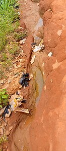 A Gully formed by flood in Isuaniocha community of Anambra State, Nigeria
_1.jpg)
_3.jpg)
_-_REFON_3.JPG)


See also
- Arroyo (creek)– Dry watercourse with flow after rain
- Badlands – Type of heavily eroded terrain
- Coulee – Type of valley or drainage zone
- Couloir – Steep, narrow mountain gully – a narrow gully with a steep gradient in a mountainous terrain
- Dale (landform) – Open valley
- Draw (terrain)– Terrain feature formed by two parallel ridges or spurs with low ground in between
- Gulch – Deep V-shaped valley formed by erosion
- Lavaka – Type of gully, formed via groundwater sapping
- Linn (geography)– gully in Scotland or Northern England in rock
- Ravine – Small valley, often due to stream erosion
- Rill – Shallow channel cut by water – a shallow channel cut into soil by erosion from flowing water
- Terrace Crossing - a geographical zone between the sedimentation (downstream) part and the erosion (upstream) part of a river
- Wadi – River valley, especially a dry riverbed that contains water only during times of heavy rain
References
- Oxford English Dictionary[full citation needed]
- ^ "Definition of GULLY". www.merriam-webster.com. 2023-10-21. Retrieved 2023-10-22.
- ISSN 0895-769X.
- ^ "gully | Etymology, origin and meaning of gully by etymonline". www.etymonline.com. Retrieved 2023-10-22.
- ^ a b Department of Jobs, Precincts and Regions (2020-06-04). "Gully erosion - Agriculture". Agriculture Victoria. Retrieved 2023-10-22.
- S2CID 203849080.
- ^ "Journal of Research in Forestry, Wildlife and Environment". www.ajol.info. Retrieved 2023-10-22.
- ^ "Gully Erosion, Definition, Causes, Effects And Prevention - Jotscroll". www.jotscroll.com. 2020-04-29. Retrieved 2023-10-23.
- S2CID 228807598.
- ^ "Gully Erosion, Definition, Causes, Effects And Prevention - Jotscroll". www.jotscroll.com. 2020-04-29. Retrieved 2023-10-23.
- S2CID 228807598.
- ^ Department of Jobs, Precincts and Regions (2020-06-04). "Gully erosion - Agriculture". Agriculture Victoria. Retrieved 2023-10-23.
- S2CID 130635566.
- ISSN 2141-1824.
- S2CID 198419282.
- ^ bibliotekanauki.pl https://bibliotekanauki.pl/articles/1031662. Retrieved 2023-10-23.
{{cite web}}: Missing or empty|title=(help) - S2CID 219070139.
- S2CID 258089564.
- ^ "osondu.com - This website is for sale! - osondu Resources and Information". www.osondu.com. Retrieved 2023-10-22.
{{cite web}}: Cite uses generic title (help) - PMID 12594459.
- ^ Costard, F. , Forget, F. , Mangold, N. & Peulvast, J. P. Formation of recent martian debris flows by melting of near-surface ground ice at high obliquity. Science 295, 110–113
- ^ Malin M. C. and Edgett K. S. (2000) Science, 288, 2330–2335.
External links
 Media related to Gully at Wikimedia Commons