
Gush Dan
Gush Dan
| |
|---|---|
| Postal code | 61999 |
| Area code | +972 (Israel) |
Gush Dan (
History
| Year | Pop. | ±% |
|---|---|---|
| 1946 | 343,000 | — |
| 1956 | 845,000 | +146.4% |
| 1966 | 1,291,000 | +52.8% |
| 1976 | 1,661,000 | +28.7% |
| 1986 | 2,036,000 | +22.6% |
| 1996 | 2,547,000 | +25.1% |
| 2006 | 3,098,000 | +21.6% |
| 2016 | 3,854,000 | +24.4% |
| Source: [5][6][7] | ||
The name Gush Dan means "Dan Bloc", and is so named because the area was the territory of the
The city of Tel Aviv grew rapidly in the ensuing decades by
In 1947, the Jewish population of the Gush Dan was nearly 400,000 and was the majority of the Jewish population of Mandatory Palestine. As such, almost all of it was included in the Jewish state proposed by the 1947 United Nations Partition Plan for Palestine. After the 1948 Arab–Israeli War, the Arab population of the region, which had been nearly 150,000 before the war,[9] was reduced to around 10,000. They were quickly replaced by a larger number of Jews fleeing from postwar Europe and persecution in Arab countries.
However, many new immigrants did not then come to Tel Aviv. In the 1950s, towns were built on the edges of the Gush Dan, including Ashdod, Rosh HaAyin and Yavne. The nation's sole port was then located in the northern city of Haifa and its evolving metropolitan area, making that city at least as important as Tel Aviv. The new government was then trying to disperse the nation's population to the periphery and discouraged settlement in the already-populated Gush Dan. That slowed the growth of the Gush Dan, but the area still more than doubled in population within 20 years of the establishment of Israel. The opening of the Port of Ashdod in the southern Gush Dan also increased the area's importance, with the importance of Haifa diminishing and that of Tel Aviv increasing because of its proximity. Tel Aviv itself witnessed population decreases in the 1970s and 1980s, when outer regions of the Gush Dan with lower costs of living absorbed many of the people who had left Tel Aviv.
Only in the 1990s, with the immigration of more than 1 million Jews
Despite some successes in ongoing attempts by the Israeli government to encourage migration to the Galilee and the Negev, Gush Dan retains its position as the heart of Israel.
Cities in Gush Dan
Population in cities as of the end of 2021:[11]
- Over 400,000
- Tel Aviv-Yafo474,530
- Over 200,000
- Rishon LeZion 260,453
- Petah Tikva 255,387
- Ashdod 226,827
- Netanya 233,104
- Bnei Brak 218,357
- Over 100,000
- Holon 197,957
- Ramat Gan 172,486
- Ashkelon 153,138
- Rehovot 150,748
- Bat Yam 128,465
- Herzliya 106,741
- Kfar Saba 101,556
- Over 50,000
- Modi'in-Maccabim-Re'ut 99,171
- Lod 85,351
- Ra'anana 80,260
- Ramla 79,132
- Rosh HaAyin 73,678
- Hod HaSharon 65,614
- Givatayim 61,924
- Yavne 56,232
- Ness Ziona 50,341
- Over 20,000
- El'ad 49,487
- Ramat HaSharon 48,181
- Tayibe 46,020
- Kiryat Ono 43,241
- Yehud-Monosson 31,405
- Gedera 31,438
- Be'er Ya'akov 31,325
- Giv'at Shmuel 28,994
- Kfar Yona 29,450
- Tira 27,802
- Kafr Qasim 25,285
- Gan Yavne 24,574
- Qalansawe 24,205
- Kadima-Zoran 23,220
- Ganei Tikva 23,646
- Shoham 22,731
- Over 10,000
- Mazkeret Batya 15,726
- Even Yehuda 14,365
- Tel Mond 14,477
- Kiryat Ekron 10,993
- Jaljulia 10,609
-
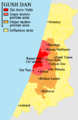 Map of the Gush Dan
 -
 Map of inner metropolitan area
 -
 Satellite Image of the Inner Ring of the Gush Dan
 -
 NASA photo of Tel Aviv area at night


.jpg)
Metropolitan rings
Israel Central Bureau of Statistics divides the Tel Aviv metropolitan area into four:
| Metropolitan ring | Localities | Population (EOY 2018 estimate) | Population density (per km²) |
Annual Population growth rate | |||
|---|---|---|---|---|---|---|---|
| Total | Jews and others1 | Thereof: Jews | Arabs | ||||
| Core2 | 1 | 451,500 | 431,100 | 407,200 | 20,400 | 8,718.6 | 1.7% |
| Inner Ring3 | 13 | 975,600 | 973,700 | 911,900 | 2,000 | 8,097 | 1.4% |
| Northern Section | 4 | 144,300 | 144,100 | 138,800 | 200 | 3,327.4 | 1.3% |
| Eastern Section | 5 | 495,100 | 494,400 | 479,600 | 700 | 12,394.3 | 1.9% |
| Southern Section | 4 | 336,300 | 335,200 | 293,500 | 1,100 | 9,042.2 | 0.6% |
| Middle Ring4 | 31 | 1,219,800 | 1,177,300 | 1,108,100 | 42,500 | 4,157.4 | 1.6% |
| Northern Section | 6 | 239,500 | 239,200 | 232,300 | 300 | 4,567.4 | 1.3% |
| Eastern Section | 8 | 325,700 | 325,300 | 304,400 | 400 | 4,558.6 | 1.7% |
| Southern Section | 17 | 654,500 | 612,800 | 571,500 | 41,800 | 3,861.5 | 1.7% |
| Outer Ring5 | 258 | 1,338,000 | 1,200,200 | 1,140,700 | 137,800 | 1,052.9 | 2% |
| Northern Section | 97 | 497,100 | 397,300 | 375,100 | 99,800 | 1,284.9 | 1.3% |
| Eastern Section | 47 | 294,700 | 258,000 | 254,200 | 36,700 | 1,056.4 | 3.3% |
| Southern Section | 91 | 453,300 | 452,600 | 424,200 | 700 | 877.3 | 1.4% |
| Judea and Samaria Section6 | 23 | 93,000 | 92,300 | 87,200 | 600 | – | 4.3% |
| Total | 303 | 3,984,900 | 3,782,300 | 3,567,900 | 202,700 | 2,361.4 | 1.7% |
- 1 The population of "Jews and others" includes Israeli Jews, non-Arab Christians and those not classified by religion.
- 2 The core area includes the city of Tel Aviv.
- 3 The inner ring includes the cities , as well as a multitude of smaller towns (local councils).
- 4 The middle ring includes the cities Petah Tikva, Ra'anana, Rishon LeZion, Hod HaSharon, Kfar Saba, Yehud, Ramla, Lod, Rosh HaAyin, Ness Ziona and Rehovot, as well as many smaller towns (local councils).
- 5 The outer ring includes the cities Tayibe, Netanya, Modi'in-Maccabim-Re'ut, Ashdod, as well as many smaller towns (local councils).
- 6 Judea and Samaria Section refers to Ari'el, as well as many smaller settlements. The international community considers Israeli settlements in the West Bank illegal under international law, but the Israeli government disputes this.[13] The statistic does not however include the Palestinian localities located east of the Green Line.
Business and commercial districts


- Gibor Sport House.
- Dizengoff Square – Tel Aviv – Dizengoff Center (Hebrew: דיזנגוף סנטר) is a shopping mall in central Tel Aviv, host to about 140,000 visitors weekly. Lying south of Dizengoff Square, it is named for Meir Dizengoff, the first mayor of Tel Aviv. The first mall in Tel Aviv, the center opened in 1983. It is divided into two parts and straddles both sides of Dizengoff Street with the two parts linked by a pair of skywalks. The mall is bordered by Dizengoff Street, King George Street and the smaller Tchernichovsky street.
- Lachish River. Its establishment doubled the country's port capacity.
- Rothschild Boulevard – Tel Aviv – Rothschild Boulevard (Hebrew: שְׂדֵרוֹת רוטשילד, Sderot Rothschild) is a street in Tel Aviv beginning in Neve Tzedek at its southwestern edge and running north to Habima Theatre. It is one of the busiest and most expensive streets in the Gush Dan, being one of the city's main tourist attractions.[14]
- skyscrapers in Tel Aviv. At the base of the center lies a large shopping mall. The center was originally designed by Israeli-American architect Eli Attia, and after he fell out with the developer of the center David Azrieli (after whom it is named), completion of the design was passed on to the Tel Aviv firm of Moore Yaski Sivan Architects.
- Tel Aviv Stock Exchange – Tel Aviv – The Tel Aviv Stock Exchange (TASE; Hebrew: הבורסה לניירות ערך בתל אביב; colloquially known as the Boursa) is Israel's only stock exchange. The TASE is the only public market for trading securities in Israel. It plays a major role in the Israeli economy. TASE lists some 622 companies, about 60 of which are also listed on stock exchanges in other countries. TASE also lists some 180 exchange-traded funds (ETFs), 60 government bonds, 500 corporate bonds, and more than 1000 mutual funds. 29 companies are members of the TASE, of which 14 are banks. The list of members indicates that Altshuler Shaham Ltd is a candidate for membership.
- Tel Aviv Promenade – Tel Aviv – The Tel Aviv promenade runs along its beaches, and is an integral part of the city's lifestyle, as well as a major tourist attraction. Most of the city's bathing beaches and hiking paths are concentrated in the central part of its 14 kilometers of Mediterranean shore. It contains numerous hotels and commercial buildings.
- Kiryat Atidim – Tel Aviv – high tech center in eastern Ramat HaHayal. The district is known for its ultra modern architecture.
- Bat Yam coastal strip – Bat Yam - southward extension of the Tel Aviv Promenade
- Herzliya Pituah coastal strip and industrial area – Herzliya – northward extension of the Tel Aviv Promenade
- Kiryat Aryeh, Kiryat Matalon, and Segula Industrial Zones – (These three form the second largest industrial zone in the country after Haifa) – Petah Tikva
- Ben Gurion Airport Industrial Zone – Lod
- Eastern Industrial Sector – Holon
- Eastern Industrial Zones – Netanya
- Poleg industrial area – Netanya
Higher education


- Universities
- Tel Aviv University (TAU) (Tel Aviv) – 30,000 students[15]
- Bar-Ilan University (BIU) (Ramat Gan) – 27,000 students
- Open University of Israel (OPENU) (Ra'anana) – 40,000 students
- Weizmann Institute of Science (WIS) (Rehovot) – 700 students
- Veterinary Medicine.
- Colleges
- Academic Center of Law and Business, Ramat Gan
- Academic College of Tel Aviv–Yafo, Tel Aviv
- Bezalel Academy of Art and Design
- College of Management(COLMAN), Rishon LeZion
- Holon Institute of Technology
- Interdisciplinary Center(IDC), Herzliya
- Jerusalem College of Technology
- Netanya Academic College
- Netanya Academic College of Law
- Ono Academic College
- The Center for Academic Studies in Or Yehuda
- Shenkar College of Engineering and Design
- College of Technology Education, Tel Aviv
- Kibbutzim College of Education, Tel Aviv
- Levinsky College of Education, Tel Aviv
- Mofet, Consortium of Colleges of Education
- Moreshet Yaakov Religious College of Education, Rehovot
- Ort College for Teachers of Technology, Tel Aviv
- Talpiot College of Education, Tel Aviv
Shopping centers


- Carmel Market
- Ramat Aviv Mall
- Azrieli Center
- Dizengoff Center
- Tel Aviv Central Bus Station
- Opera Tower
- London Ministores Mall
Transportation

The
Highways
Some of the major freeways/expressways carrying commuter traffic in and out of the Tel Aviv Metropolitan Area are:
- freewayin Gush Dan, which runs along Tel Aviv's center eastern border from north to south.
- Highway 1 – connects Tel Aviv with Jerusalem.
- Highway 2 (also called The Coastal Highway) – stretches from Tel Aviv to Haifa. It is one of the busiest highways in Israel.
- in the South.
- Ariel and other Israeli settlements in the northern West Bank.
- Shefela.
- Beer Shevain the south.
Panoramas
.jpg)


See also
References
- ^ LOCALITIES, POPULATION AND DENSITY PER SQ. KM. OF LAND, BY METROPOLITAN AREA(1) AND SELECTED LOCALITIES (PDF) (Report). Israel Central Bureau of Statistics. 2022. Retrieved April 15, 2023.
- ^ a b "Localities, Population, and Density" (PDF). Archived from the original (PDF) on 2016-04-15. Retrieved 2010-01-24.
- ^ "Instead of talking about national economy, we should talk about cities". www.calcalist.co.il.
- ^ "World Economic Outlook database: October 2023". www.imf.org.
- ^ "Population of Israel on the Eve of 2018 - 8.8 Million". Press Release. Israel Central Bureau of Statistics. 31 December 2017. Retrieved 2 January 2018.
- ^ "Population, by Population Group". Statistical Abstract of Israel. Israel Central Bureau of Statistics. 11 September 2012. Retrieved 5 April 2013.
- ^ "Monthly Bulletin of Statistics for Population". Israel Central Bureau of Statistics. 7 August 2013. Retrieved 24 August 2013.
- ^ Census data [permanent dead link]
- ^ a b "Tel Aviv-Yafo-Statistical Overview". Archived from the original on 2014-09-13. Retrieved 2016-02-06.
- ^ Map cbs.gov.il [dead link]
- ^ "Regional Statistics". Israel Central Bureau of Statistics. Retrieved 21 March 2024.
- ^ "Localities, Population and Density Per sq. km., by Metropolitan Area and Selected Localities" (PDF). Israel Central Bureau of Statistics. September 26, 2019. Retrieved October 10, 2019.
- ^ "The Geneva Convention". BBC News. 10 December 2009. Retrieved 27 November 2010.
- ^ Mirovsky, Arik. "For a prestigious address, nothing beats Rothschild". Haaretz. Archived from the original on 2009-06-21. Retrieved 2006-10-08.
- ^ "Tel Aviv University ranked first in Israel by QS World University Ranking". The Jerusalem Post | JPost.com. 2023-07-02. Retrieved 2024-03-24.
- ^ "Something went wrong..." en.hafakulta.agri.huji.ac.il. Retrieved 29 December 2023.
- ^ "Sde Dov Airport closes". Globes (in Hebrew). 2019-06-30. Retrieved 2020-07-06.
External links

| International | |
|---|---|
| National | |