
Hadejia
Hadejia
Biram | |
|---|---|
UTC+1 (WAT) | |
 |
Haɗejiya (also Haɗeja, previously Biram) is a
Hadejia was once known as Biram, and is referred to as one of the "seven true
The Haɗeja consist of 4 tertiary institutions namely: Binyaminu Usman Polytechnic Hadejia,[8] School of Nursing Hadejia,[9] National Teachers Institutes Hadejia Study Centre.[10]
Agricultural Products
Hadejia town, a market center for cotton, millet, sorghum, fish, and rice, is an export crop for peanuts. Locals maintain cattle, goats, guinea fowl, sheep, and donkeys. It is connected to the main highway and railway.[11][12][13]
Climate
The climate has a blistering, cloudy dry season with temperatures ranging from 59°F to 105°F, as well as a hot, oppressive rainy season with predominantly cloudy skies.[14]
Air Pollution
Hadejia's air undergoes significant changes due to the presence of dust and particulate matter, which pose significant health risks due to their small size and potential inhalation into the lungs.[15][16][17]
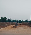
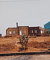
Gallery
- Commerce and administration
-
 Meat market Hadejia
 -
 Hadejia fish market
 -
 Milk market Hadejia
 -
 Toward the entrance to the Hadejia Market
 -
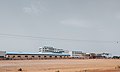 Abandoned Sugar refinery company in Hadejia
 -
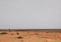 Farmland in eastern Hadejia
 -
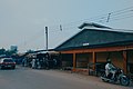
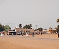
 Downtown Hadejia
 -
 The Central Office, Hadejia
 -
 Hisbah Office


- GLAM and educational institutes
-
 Hadejia Museum
 -
 IZALA University, under construction
 -
 The old primary school


- Culture
-
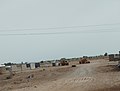
 Hadejia Cemetery
 -
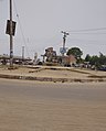 A runabout in central Hadejia, past Gate Western
 -
 A colonial residence near Hadejia city
 -
 Nguru Road toward NATO Motor Park
 -
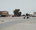 A roundabout at Gumel-Madana-Malam Maduri-Hadejia
 -
 Outside Koga Market Mosque, Hadejia
 -
 Emir's Palace Hadejia
 -
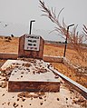 Grave of Captain Phillips (kabarin mai tumbi)


References
- ^ "Hadejia". Encyclopædia Britannica. Encyclopædia Britannica, Inc. Retrieved 22 December 2006.
- ^ GPS Coordinates: "https://latitude.to/map/ng/nigeria/cities/hadejia"
- ^ Isah Abubakar (2018) "Use of ICT among Extension Agents in Hadejia Local Government" Unpublished work
- ^ Chiroma, Muhammad J.; Kazaure, Yahaya D.; Karaye, Yahya B.; Gashua, Abba J. "Water Management Issues in the Hadejia-Jama'are-Komadugu-Yobe Basin: DFID-JWL and Stakeholders Experience in Information Sharing, Reaching Consensus and Physical Interventions" (PDF). International Water Management Institute. Retrieved 3 October 2009.
- ^ "Daura". Encyclopædia Britannica. Encyclopædia Britannica, Inc. Retrieved 21 December 2006.
- ^ Lange, Dierk. "Oral version of the Bayajidda legend" (PDF). Ancient Kingdoms of West Africa. Retrieved 21 December 2006.
- ^ Johnston, H. A. S (1967). "The Consolidation of the Empire". The Fulani Empire of Sokoto. Amana Online. Retrieved 21 January 2007.
- ^ "BINYAMINU USMAN POLYTECHNIC – P.M.B 013 Hadejia, Jigawa State".
- ^ "Jigawa State School of Nursing Hadejia - ONLINE APPLICATION". jisconmhadejia.admissions.cloud.
- ^ "National Teachers' Institute Kaduna". Archived from the original on 26 May 2022. Retrieved 7 May 2020.
- ^ Angbulu, Stephen (25 January 2023). "FG approves N10bn for Hadejia airstrip, Enugu control tower". Punch Newspapers. Retrieved 21 August 2023.
- ^ Nigeria, Guardian (1 February 2023). "Hadejia Valley irrigation will improve investment in agric, says minister". The Guardian Nigeria News - Nigeria and World News. Retrieved 21 August 2023.
- ^ "FULL LIST: Ikorodu, Ota, Wamba, Hadejia, areas that may experience flooding this week - Daily Trust". dailytrust.com. Retrieved 21 August 2023.
- ^ "Hadejia Climate, Weather By Month, Average Temperature (Nigeria) - Weather Spark". weatherspark.com. Retrieved 8 September 2023.
- ^ "Air Quality & Pollen Forecast for Hadejia". meteoblue. Retrieved 24 September 2023.
- ^ "Hadejia Air Quality Index (AQI) and Nigeria Air Pollution | IQAir". www.iqair.com. 24 September 2023. Retrieved 24 September 2023.
- ^ "Air Quality Hadejia: Live air quality and pollution Forecasts". Plume Labs Air Report. Retrieved 24 September 2023.
External links
- Official website Website of the Hadejia Emirate (archived)
12°27′N 10°02′E / 12.45°N 10.04°E
State capital: Dutse | ||
| Local Government Areas |
|  |