
Hamina
Hamina
Fredrikshamn | |
|---|---|
Town | |
| Haminan kaupunki Fredrikshamns stad | |
Reserve Officer School, the countryside of Husula neighbourhood, a view from the Sailor Pavilion towards Tervasaari and the historical Town Hall. | |
|
Population by age | |
| • 0 to 14 | 12.8% |
| • 15 to 64 | 57.2% |
| • 65 or older | 30% |
| Time zone | UTC+02:00 (EET) |
| • Summer (DST) | UTC+03:00 (EEST) |
| Climate | Dfb |
| Website | www.hamina.fi |
Hamina (Finnish pronunciation:
Highway 7 (E18) is the town's road connection to Helsinki, after it was upgraded to a continuous motorway in September 2014. Hamina is also the base of one of the most important harbors of Finland, the Port of Hamina-Kotka. The port specializes in forest products and the transit of cargo to Russia. One of Google's five European data centers is situated in Hamina.[7]
History
Vehkalahti was as a municipality first mentioned in 1336. At the proposal of Count Per Brahe, the area surrounding the Vehkalahti church (today St. Mary's Church) received its charter in 1653 through the establishment of Vehkalahden Uusikaupunki (Veckelax Nystad in Swedish, "The New Town of Vehkalahti"). The town was later destroyed during the Great Northern War in 1712.[8]

As the commercially vibrant city of
In 1743, Hamina was surrendered to Russia, after the
The
Because the town was founded next to the Vehkalahti Church, the municipal center had always been inside the town borders. Vehkalahti and Hamina were consolidated in 2003, and the old coat of arms was replaced with Vehkalahti's coat of arms. The old coat of arms was readopted in January 2013.[11]
Results of the
Main sights
- Town Hall: Originally built in 1798, it was renovated by Carl Ludvig Engel in 1840.
- Reserve Officer School: The site which trains reserve officers in the Army Academy of the Finnish Army
- Town Museum: It is located in a building where King Catherine II of Russia met in 1783.[13]
- Shopkeeper's Museum
- Google Data Center: (former Stora Enso pulp factory)
- star forts in Finland. The corners of the fortress form six bastions, named after towns in Finland. The Central Bastion was added at the end of the 18th century, and is currently used for cultural events.
Churches
- St. Mary's Church, previously known as Vehkalahti Church, is the oldest building in Kymenlaakso. It was originally built in the Middle Ages, but it was burnt in 1821 and the current neoclassical exterior is designed by Carl Ludvig Engel and completed in 1828. The church has a museum dedicated to the church life from the 18th century onwards.[14][15]
- St. John's Church, formerly known as Hamina Church, was built between 1841-1843. It was designed by Carl Ludvig Engel in the neoclassical style.[16]
- Italian-French architect Louis Visconti. The architecture of the church is combination of neoclassical and Byzantine elements.[17]
-
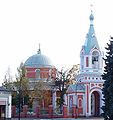 The orthodox church of Peter and Paul
 -
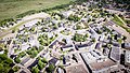 Aerial view of the town
 -
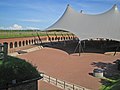 Central bastion of the fortress
 -
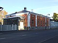 The town museum


Twin towns
Notable people

- Magnus Enckell (1870–1925), symbolist painter
- military sniper
- Pelle Miljoona (born 1955), a musician
- Hugo Simberg (1873–1917), a painter
- Emilie Mechelin (1838–1917), opera singer and pedagogue
- Leo Mechelin (1839–1914), a professor, statesman, senator and liberal reformer
- Keke Rosberg (born 1949), racing driver
- Meri Toppelius (1863–1896), educational theorist
See also
References
- ^ a b "Area of Finnish Municipalities 1.1.2018" (PDF). National Land Survey of Finland. Retrieved 30 January 2018.
- ^ "Immigration record high in Finland in 2023". StatFin. Statistics Finland. Retrieved 25 January 2024.
- ^ "Demographic Structure by area as of 31 December 2022". Statistics Finland's PX-Web databases. Statistics Finland. Retrieved 6 September 2023.
- ^ "Population according to age (1-year) and sex by area and the regional division of each statistical reference year, 2003–2020". StatFin. Statistics Finland. Retrieved 2 May 2021.
- ^ a b "Luettelo kuntien ja seurakuntien tuloveroprosenteista vuonna 2023". Tax Administration of Finland. 14 November 2022. Retrieved 7 May 2023.
- ^ "Population by municipality as of 31 December 2008". Population Information System (in Finnish and Swedish). Population Register Center of Finland. Archived from the original on 2010-12-02. Retrieved 27 March 2010.
- ^ Hamina Data Center - Google Data centers
- ^ a b Hamina
- ^ Lindberg, Johan (May 26, 2016). "Finlands historia: 1700-talet". Uppslagsverket Finland (in Swedish). Retrieved November 30, 2017.
- ^ Kopomaa, Timo (2005). "Kriisioloihin varautunut kaupunki" (PDF). Yhdyskuntasuunnittelu (in Finnish). 43 (2). Helsinki: Yhdyskuntasuunnittelun seura ry (The Finnish Society of Housing and Planning): 6–26. Retrieved 25 January 2009.
- ^ Haminan vaakuna vaihtuu - Haminan kaupunki (in Finnish) Archived 2013-02-13 at archive.today
- ^ "Finns Party gains, NCP top as turnout dips in Finnish local elections". 13 June 2021.
- ^ Hamina
- ^ Hurmaava Hamina - The 15th century church of St Mary and church Museum Archived 2013-02-17 at archive.today
- ^ Churches in Finland
- ^ Hurmaava Hamina - Church Of St John Archived 2013-02-17 at archive.today
- ^ Hurmaava Hamina - The Orthodox Church Of St Peter and St Paul Archived 2013-02-17 at archive.today
- ^ Vordingborg Kommune har 17 venskabsbyer Archived 2014-07-05 at the Wayback Machine
- ^ Hurmaava Hamina - Info Archived 2011-11-29 at the Wayback Machine
External links
- Official website of Hamina in English Archived 2013-06-04 at the Wayback Machine
- Guide map of Hamina
- Map of Hamina
- Hamina-Fredrikshamn at Northern Fortress
Places adjacent to Hamina | |
|---|---|
| Municipalities |  | |
|---|---|---|
| Former municipalities |
| |
| International | |
|---|---|
| National | |
| Geographic | |