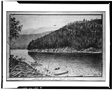
Henderson Lake (New York)
| Henderson Lake | ||
|---|---|---|
Primary inflows Indian Pass Brook, Santononi Brook, Harkness Brook | | |
| Primary outflows | Hudson River | |
| Basin countries | United States | |
| Surface area | 281 acres (1.14 km2)[1] | |
| Max. depth | 70 ft (21 m) | |
| Surface elevation | 1,814 ft (553 m)[1] | |
| References | https://extapps.dec.ny.gov/docs/fish_marine_pdf/tb519064.pdf | |


Henderson Lake is located in the
Tahawus, New York.[3] The lake is mainly cited by cartographers as the place where the Hudson River as named officially begins, flowing out of the eastern end and outlet of the lake.[4][5][6] Unofficially, the source of the river is traced up Indian Pass Brook and other watercourses to Lake Tear of the Clouds.[7]

Notes
- ^ a b c "Henderson Lake". Geographic Names Information System. United States Geological Survey, United States Department of the Interior. Retrieved December 2, 2021.
- ^ Donaldson pp. 137.
- ^ Donaldson pp. 137-138.
- ^ U.S. Geological Survey Geographic Names Information System: Hudson River
- ^ U.S. Geological Survey Geographic Names Information System: Indian Pass Brook
- ^ U.S. Geological Survey Geographic Names Information System: Calamity Brook
- ^ "Natural History of the Hudson River". Hhr.highlands.com. Archived from the original on September 17, 2013. Retrieved February 16, 2014.
Sources
- Donaldson, Alfred Lee. "A history of the Adirondacks, volume 1". The Century Co. New York, 1921.
- Stanne, Stephen P., Panetta, Roger G., and Forist, Brian E. "The Hudson: An Illustrated Guide to the Living River". Rutgers University Press, 1996.
