
Hermel
Hermel
الهرمل | |
|---|---|
UTC+2 (EET) | |
| • Summer (DST) | +3 |


Hermel (
There is an ancient pyramid known as Kamouh el Hermel (Pyramid or Needle of Hermel) located about 6 kilometres (3.7 mi) south of the town that is a popular attraction for local tourists.[4]
History
In 1519 and 1545, the town was under the administration of the nahiyah ("subdistrict") of Manasef, and tax records indicate it had 50 households, all Muslims. The town's population swelled after the Hamade family and their associated Shia clans left Mount Lebanon to settle in Hermel and its surroundings, which were already part of the Hamade's tax-concessions since 1668.[5]
Archaeology
Hermel plains
The Hermel plains are an area of low hills around Hermel, through which runs the
Hermel I (Mrah Abbas)
Hermel I or Mrah Abbas was discovered by Shiat Ali el Karar w beit hmede and is 5 kilometres (3.1 mi) north northeast of Hermel, 1 kilometre (0.62 mi) before reaching
Hermel II (Jisr el Aassi)
Hermel II or Jisr el Aassi is 2 kilometres (1.2 mi) east of Hermel I near the gorge through which the Orontes river flows. It was found by P. Billaux and mentioned by Maurice Tallon in 1958 who made a lengthy description of the largest tumulus in 1959.
Hermel III (Choueighir)
Hermel III or Choueighir is a village on the left (western) bank of the Orontes and an archaeological site was found by P. Billaux 2 kilometres (1.2 mi) to the north of it.
Hermel IV (Wadi el Joz)
Hermel IV or Wadi el Joz is a collection of
References
- ^ "Hermel". Localiban.
- ^ Our Centers Archived 2006-02-12 at the Wayback Machine
- ^ "Car bomb blasts Lebanese town near Syria border", The Guardian, 2014-01-16
- ISBN 978-1-84162-370-2. Retrieved 26 September 2012.
- ISBN 9781139486811.
- ^ Lorraine Copeland; P. Wescombe (1965). Inventory of Stone-Age sites in Lebanon, p. 43 & 45. Imprimerie Catholique. Retrieved 21 July 2011.
- ^ a b c d L. Copeland; P. Wescombe (1966). Inventory of Stone-Age Sites in Lebanon: North, South and East-Central Lebanon, p. 32-33. Impr. Catholique. Retrieved 3 March 2011.
- ^ a b c Tallon, Maurice., Tumulus et Mégalithes du Hermel et de la Beqa Nord. MUSJ, vol. 31, fasc. 3, p. 91, 1959.
- ^ Fleisch, Henri. Notes de Préhistoire Libanaise: 1) Ard es Saoude. 2) La Bekaa Nord. 3) Un polissoir en plein air. BSPF, vol. 63, 1966.
|
Middle Eastern megaliths | ||
|---|---|---|
| Lebanon | 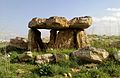 | |
| Syria | ||
| Saudi Arabia | ||
| Israel | ||
| Jordan | ||
| Turkey | ||
| Egypt | ||
| Iran | ||
| Iraq | ||
| General articles |
| |
Capital: Hermel | ||
 | ||
| International | |
|---|---|
| National | |
| Geographic | |