
High Street station (IND Eighth Avenue Line)
High Street NYCT Bus: B25 | ||||||||||||||||||||||||||||||||||||||||||||||||||||||||||||||||||||||||||||||||||
|---|---|---|---|---|---|---|---|---|---|---|---|---|---|---|---|---|---|---|---|---|---|---|---|---|---|---|---|---|---|---|---|---|---|---|---|---|---|---|---|---|---|---|---|---|---|---|---|---|---|---|---|---|---|---|---|---|---|---|---|---|---|---|---|---|---|---|---|---|---|---|---|---|---|---|---|---|---|---|---|---|---|---|
| Structure | Underground | |||||||||||||||||||||||||||||||||||||||||||||||||||||||||||||||||||||||||||||||||
| Platforms | 1 island platform | |||||||||||||||||||||||||||||||||||||||||||||||||||||||||||||||||||||||||||||||||
| Tracks | 2 | |||||||||||||||||||||||||||||||||||||||||||||||||||||||||||||||||||||||||||||||||
| Other information | ||||||||||||||||||||||||||||||||||||||||||||||||||||||||||||||||||||||||||||||||||
| Opened | June 24, 1933[2] | |||||||||||||||||||||||||||||||||||||||||||||||||||||||||||||||||||||||||||||||||
| Opposite- direction transfer | Yes | |||||||||||||||||||||||||||||||||||||||||||||||||||||||||||||||||||||||||||||||||
| Former/other names | High Street–Brooklyn Bridge, Brooklyn Bridge Plaza, Cranberry Street | |||||||||||||||||||||||||||||||||||||||||||||||||||||||||||||||||||||||||||||||||
| Traffic | ||||||||||||||||||||||||||||||||||||||||||||||||||||||||||||||||||||||||||||||||||
| 2023 | 2,247,144[3] | |||||||||||||||||||||||||||||||||||||||||||||||||||||||||||||||||||||||||||||||||
| Rank | 153 out of 423[3] | |||||||||||||||||||||||||||||||||||||||||||||||||||||||||||||||||||||||||||||||||
| ||||||||||||||||||||||||||||||||||||||||||||||||||||||||||||||||||||||||||||||||||
| ||||||||||||||||||||||||||||||||||||||||||||||||||||||||||||||||||||||||||||||||||
| ||||||||||||||||||||||||||||||||||||||||||||||||||||||||||||||||||||||||||||||||||
| ||||||||||||||||||||||||||||||||||||||||||||||||||||||||||||||||||||||||||||||||||
| ||||||||||||||||||||||||||||||||||||||||||||||||||||||||||||||||||||||||||||||||||


The High Street station, also signed as High Street–Brooklyn Bridge, and also referred to as Brooklyn Bridge Plaza and Cranberry Street, train at all times except late nights.
History

The High Street station was part of a three-stop extension of the IND Eighth Avenue Line from
The extension opened to Jay Street on February 1, 1933, but the High Street station remained closed for an additional five months. The trains ran through the station without stopping, because the
The station was located below the sites of the
The High Street station was the site of an attempted robbery of subway revenue on June 18, 1954, in which the unarmed perpetrator was fatally shot by one of the two armed transit employees collecting fares and already-used transfer slips from token booths.[15]
In the 1970s, the escalators at the eastern end of the station to Adams Street were replaced.[16] New York City councilmember Lincoln Restler founded a volunteer group, the Friends of MTA Station Group, in early 2023 to advocate for improvements to the High Street station and four other subway stations in Brooklyn.[17][18]
Station layout
| Ground | Street level | Exit/entrance |
| Mezzanine | Fare control, station agent, escalators | |
| Platform level | Northbound | ← ← |
| Island platform | ||
| Southbound | Rockaway Park–Beach 116th Street (Jay Street–MetroTech) → | |


This underground station has two tracks and one
East (railroad south) of the station, the line curves south onto Jay Street
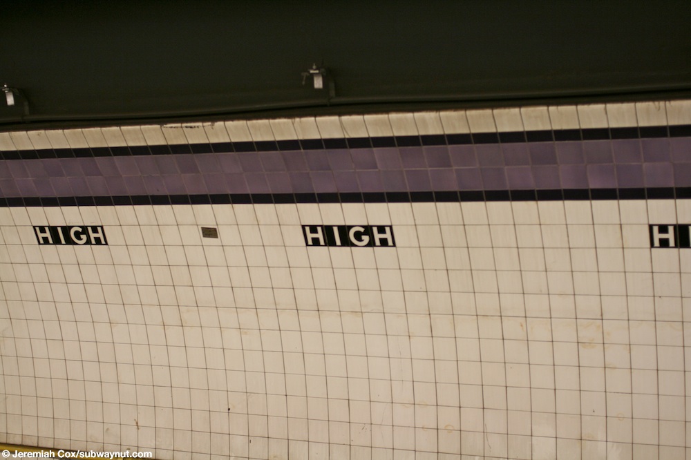
Both trackside walls have a dark lavender trim line with an eggplant border, below which are small tile captions reading "HIGH" in white lettering on a black background. Thick I-beam columns painted dark indigo run along the platform at regular intervals, alternating ones having the standard black station name plate with white lettering.[25]
Exits
There are exits at both ends to the full length
The geographic western exit leads to
Ridership
In 2017, the station had 2,983,672 boardings, making it the 171st most used station in the 425-station system. This amounted to an average of 9,215 passengers per weekday.[4] In 2014, the station had an average of 8,870 daily weekday boardings, up from 5,410 daily boardings in 2005; this represented a 64 percent ridership increase over nine years.[29] The station is the 26th busiest of all stations served by the A and C trains.[29]
References
- ^ "Glossary". Second Avenue Subway Supplemental Draft Environmental Impact Statement (SDEIS) (PDF). Vol. 1. Metropolitan Transportation Authority. March 4, 2003. pp. 1–2. Archived from the original (PDF) on February 26, 2021. Retrieved January 1, 2021.
- ^ a b c d e f "Jobs Are All Filled on Subway Links – Board Reports Thousands Already Listed – High St. Station, Brooklyn, Opened" (PDF). The New York Times. June 25, 1933. Archived from the original on December 17, 2021. Retrieved October 27, 2015.
- ^ a b "Annual Subway Ridership (2018–2023)". Metropolitan Transportation Authority. 2023. Retrieved April 20, 2024.
- ^ a b "Annual Subway Ridership (2018–2023)". Metropolitan Transportation Authority. 2023. Retrieved April 20, 2024.
- ^ a b c "City Opens Subway to Brooklyn Today: Regular Express Service on the Extension of Independent Line Starts at 6:05 A.M." (PDF). The New York Times. February 1, 1933. p. 19. Archived from the original on May 13, 2022. Retrieved October 27, 2015.
- ^ Newspapers.com.
- ^ Newspapers.com.
- Brooklyn Standard Union. November 10, 1927. p. 2. Retrieved June 30, 2016 – via Fultonhistory.com.
- ^ "New Subway Link Opens Wednesday: Independent Line Will Offer Express Service to Borough Hall in Brooklyn" (PDF). The New York Times. January 29, 1933. Archived from the original on May 13, 2022. Retrieved November 4, 2015.
- The Herald Statesman. Fultonhistory.com. February 20, 1933. Retrieved June 30, 2016.
- Newspapers.com.
- ^ "Last Train Is Run on Fulton St. 'El' – Mayor, Cashmore, Officials and Civic Leaders Make Trip to Brooklyn Terminus – Razing to Start Soon – 'Funeral' Services for Line, Built in 1888, Are Held in Kings During Afternoon". The New York Times. June 1, 1940. p. 17. Archived from the original on April 30, 2018. Retrieved December 16, 2016.
- Newspapers.com.
- ^ a b c d e f g h "MTA Neighborhood Maps: Downtown Brooklyn & Borough Hall" (PDF). mta.info. Metropolitan Transportation Authority. 2015. Archived (PDF) from the original on July 24, 2015. Retrieved August 2, 2015.
- Newspapers.com.
- ^ "Escalators Being Replaced on New York Subways" (PDF). The New York Times. November 25, 1977. Retrieved October 27, 2015.
- ^ Brendlen, Kirstyn (February 24, 2023). "Restler launches new 'Friends of MTA Station' initiative to care for 5 local subway stops". Brooklyn Paper. Retrieved May 6, 2023.
- ^ Nessen, Stephen (March 5, 2023). "Want to be 'friends' with a subway station? A Brooklyn councilmember seeks volunteers". Gothamist. Retrieved May 6, 2023.
- ^ a b "Tracks of the New York City Subway". Tracks of the New York City Subway. Retrieved October 9, 2015.
- ^ "A Subway Timetable, Effective June 26, 2022". Metropolitan Transportation Authority. Retrieved August 26, 2023.
- ^ "C Subway Timetable, Effective June 26, 2022". Metropolitan Transportation Authority. Retrieved August 26, 2023.
- ^ a b "Subway Map" (PDF). Metropolitan Transportation Authority. September 2021. Retrieved September 17, 2021.
- ^ "Taxpayer's Suit on Subway Heard – Decision Reserved on Motion to Block Interest Payment on 8th Av. Line's Bonds – Road's Status is Argued – Plaintiff Contends It Is 'Separate Railroad' — City Holds It One Unit in System". The New York Times. June 17, 1933. p. 15. Archived from the original on December 14, 2019. Retrieved April 20, 2020.
- ^ Newspapers.com.
- ^ Cox, Jeremiah (May 16, 2008). "Looking at the purple trimline with a black boarder and black High text beneath it along the platform walls at High St". subwaynut.com. Archived from the original on March 16, 2016. Retrieved December 16, 2016.
- ^ Google (July 10, 2016). "Cadman Plaza E" (Map). Google Maps. Google. Retrieved July 10, 2016.
- ^ Newspapers.com.
- ^ Photo of painted-over mosaic sign to Washington Street Archived 2016-04-28 at the Wayback Machine, subwaynut.com. The Subway Nut. Retrieved April 27, 2016.
- ^ a b Review of the A and C Lines (PDF) (Report). Metropolitan Transportation Authority. December 11, 2015. Archived from the original (PDF) on February 3, 2020. Retrieved January 19, 2016.
External links
- nycsubway.org – IND 8th Avenue: High Street/Brooklyn Bridge
- The Subway Nut—High Street – Brooklyn Bridge Pictures Archived 2016-03-04 at the Wayback Machine
- Adams Street, west of Brooklyn Bridge Approach entrance from Google Maps Street View
- Adams Street, east of Brooklyn Bridge Approach entrance from Google Maps Street View
- Old Fulton Street entrance from Google Maps Street View
- Platform from Google Maps Street View
| Eighth Ave. Line |
|
|---|---|
| |