
Highway 50 (Israel–Palestine)
  | ||||
|---|---|---|---|---|
| כביש 50 | ||||
| Menahem Begin Boulevard Hebrew: כביש בגין, romanized: Sderot Menahem Begin Begin Expressway Hebrew: שדרות מנחם בגין, romanized: Kvish Begin | ||||
 | ||||
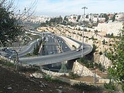
 Southward toward Rozmarin Interchange | ||||
| Route information | ||||
| Length | 15.68 km (9.74 mi) | |||
| Existed | June 1998–present | |||
| Major junctions | ||||
| South end | Rozmarin Interchange | |||
| ||||
| North end | Atarot Junction | |||
| Location | ||||
| Country | Ramot, Beit Hanina, Atarot | |||
| Highway system | ||||
| ||||
| ||||
| ||||
Highway 50 (formerly Route 404), officially called Begin Boulevard (
Route
The road follows a south-north path that connects key neighbourhoods and commercial areas, as well as several city arteries and national routes. Beginning at the Rosmarin Interchange (formerly the Tunnels Junction) of the Gush Road in Gilo, the road arcs north-westward through Gilo, Beit Safafa, and Sharafat turning northward through Malha. Passing Golomb Blvd, the road travels below a high ridge to the west on which sits the
The road then passes through two tunnels under
History

Begin Boulevard is made of the central section, which was completed two years ahead of schedule in June 1998,[3] and the northern extension completed in late 2002[4]
Since its construction, the road has been called national Route 404.
50/20
In the north, the "50/20 Interchange Project" was approved in 2010 along with the new
Begin South

The "Begin South Project", first planned in 1990, involved widening Begin Boulevard from 4 to 6 lanes and extending it as a
Further south, past the
The final stage of the project between Dov Yosef Boulevard and Rosmarin Street through the neighbourhood of Beit Safafa went ahead despite the residents' objections and requests for a tunnel. The highway was built as a slightly depressed roadway with a 200-meter-wide, park-covered bridge at al-Qa'ash St. connecting the southwest corner of the neighbourhood with its center.[12][19][20] Ongoing litigation between the residents and the municipality regarding the proximity of the highway to houses and the desire for additional crossing points continued during the construction process.[21] Construction of ramps to Rosmarin Street were completed in the spring of 2016,[22] while the underpass of Rosmarin Interchange connecting Highway 50 with Highway 60 southward was completed in September 2017.[23][24] The total cost for the project was 1.1 B Shekels.[6][25]
Future
In the center, a plan has been published to connect Begin Boulevard at Givat Mordechai Interchange to Highway 1 at the new Motza Interchange via the new
Interchanges & Junctions (South to North)
| District[28] | Location[29] | km | mi | Name | Destinations | Notes |
|---|---|---|---|---|---|---|
Highway 60 | ||||||
| Beit Safafa | 1.42 | 0.88 | מחלף דב יוסף (Dov Yosef Interchange)[30][31] | Dov Yosef Blvd. | ||
| Green Line | ||||||
| Jerusalem | Malha | 2.43 | 1.51 | מחלף מלחה (Malha Interchange) | (Yitzhak Moda'i St.) Agudat Sport HaPoel Rd. David Benvenisti St. | |
Katamonim | 3.28 | 2.04 | מחלף גולומב (Golomb Interchange) | Golomb Blvd. | ||
| Givat Mordechai | 4.32 | 2.68 | מנהרות בייט (Beyth Tunnels) | Shmuel Beyth Street | 4 lanes, 310 metres | |
| 4.57 | 2.84 | מחלף גבעת מרדכי (Givat Mordechai Interchange) | Bezalel Bazak Street | |||
| Kiryat Moshe | 6.75 | 4.19 | מחלף קרית משה (Kiryat Moshe Interchange) | Yitzhak Rabin St. | ||
| Romema | 6.83 | 4.24 | מנהרת ליפתא (Lifta Tunnel) | Jaffa Road | 6 lanes, 570 metres | |
| Givat Shaul | 7.49 | 4.65 | מחלף גבעת שאול (Givat Shaul Interchange) | |||
Route 436 | ||||||
| Green Line | ||||||
Route 436 | ||||||
Road 4197 | ||||||
| Atarot | 15.68 | 9.74 | צומת עטרות (Atarot Junction) | |||
| 1.000 mi = 1.609 km; 1.000 km = 0.621 mi | ||||||
Gallery
-
 Near Teddy Stadium and above Jaffa–Jerusalem railway
 -
 Northward toward Kiryat Moshe Interchange with noise barriers
 -
 Northward toward Givat Shaul Interchange
 -
 Northward at Yigal Yadin Interchange
 -
 Benzion Netanyahu Interchange
 -
 The old village of Beit Hanina separated from the new part of Beit Hanina by the separation barrier and Highway 50
 -
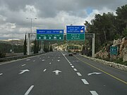
 Northward approaching Atarot Junction

.JPG)


References
- ^ "Mountain gazelles of the Gazelle Valley in Jerusalem – an urban nature reserve". Kaitholil.com. 11 January 2019. Archived from the original on 21 January 2019. Retrieved 21 January 2019.
- ^ Street View - Kryat Moshe Interchange - example of speed camera and noise barrier (Map). Google Maps. November 2011. Retrieved 25 June 2013.
- ^ Elli Wohlgelernter (17 June 1998). "Begin Boulevard opens in Jerusalem". The Jerusalem Post. Archived from the original on 29 June 2013. Retrieved 16 May 2013.
- ^ Route 4 project page from Moriah web site[permanent dead link].
- ^ Street View - Highway 45 westbound approaching Atarot Junction (Map). Google Maps. November 2011. Retrieved 25 June 2013.
- ^ a b "Continuation of Begin South (Highway 50), in Jerusalem". Ministry of Transport, National Infrastructure and Road Safety. Archived from the original on 18 December 2012. Retrieved 23 August 2011.(in Hebrew)
- ^ "Arterial road system planned for 2012". Jerusalem Municipality. sections 1 and 4. Archived from the original on 11 January 2013. Retrieved 4 August 2012.(in Hebrew)
- ^ Street View - Golomb Blvd. westbound to Begin Boulevard northbound (Map). Google Maps. July 2015. Retrieved 17 April 2018.
- ^ Street View - Golomb Blvd. eastbound to Begin Boulevard northbound (Map). Google Maps. July 2015. Retrieved 17 April 2018.
- ^ Street View - Beitar Sport Association Rd. northbound to Begin Boulevard northbound (Map). Google Maps. July 2015. Retrieved 17 April 2018.
- ^ "50/20 Interchange and Road 20". Moriah-Jerusalem Development Corporation. Archived from the original on 11 June 2012. Retrieved 16 May 2012.(in Hebrew)
- ^ a b Akiva Eldar (2 December 2011). "Israel paving road to link East Jerusalem neighborhoods to city center". Haaretz. Retrieved 16 May 2012.
- ^ "The road that will connect the north of the city to Begin open to traffic" (PDF). Jerusalem Municipality. sections 1 and 4. Archived from the original (PDF) on 22 October 2020. Retrieved 30 April 2013.(in Hebrew)
- ^ Nir Hassan (20 December 2012). "New Jerusalem highway to cut Arab neighborhood in half". Haaretz. Retrieved 25 December 2012.
- ^ "Latest Projects - Begin Highway 50". Moriah-Jerusalem Development Corporation. Archived from the original on 1 October 2011. Retrieved 23 August 2011.(in Hebrew)
- ^ "Roads Planned and Under Construction". Jerusalem Transport Master Plan Committee. Archived from the original on 18 December 2012. Retrieved 23 August 2011.(in Hebrew)
- ^ "Jerusalem's Begin Highway to be extended". Israel Transport blogspot (Summary of Hebrew references in English). 11 March 2011. Retrieved 23 August 2011.(in English)
- ^ "Jerusalem Transportation Network-map". Jerusalem Transport Master Plan Committee. Archived from the original on 16 March 2012. Retrieved 23 August 2011.(in Hebrew)
- ^ Melanie Lidman (3 August 2011). "J'lem municipality, Moriah announce highway extension plan". The Jerusalem Post. Retrieved 20 October 2011.
- nrg Maariv. Retrieved 20 October 2011.(in Hebrew)
- ^ Nir Hasson (26 June 2011). "Supreme Court gives Israel 30 days to resolve controversy over East Jerusalem highway". Haaretz. Retrieved 27 June 2013.
- ^ "The mega-road that will change the city". Jerusalem Municipality. 27 April 2014. Retrieved 16 May 2014.(in Hebrew)
- nrg Maariv. 23 November 2015. Retrieved 21 December 2015.(in Hebrew)
- ^ "Coming soon: a new southern gateway to Jerusalem". Israel Ministry of Transport, National Infrastructure and Road Safety. 25 November 2015. Retrieved 21 December 2015.(in Hebrew)
- ^ Yonah Jeremy Bob (14 October 2013). "Supreme Court hears appeal to stop road slated to traverse capital neighborhood". The Jerusalem Post. Retrieved 14 October 2013.
- ^ "Road 16, New entrance to Jerusalem, between Motza and Begin Highway". Israel Ministry of Transport, National Infrastructure and Road Safety. Archived from the original on 15 October 2013. Retrieved 2 December 2012.(in Hebrew)
- ^ "Save the Jerusalem Forest: Road 16". Forum of Organizations for the Jerusalem Forest. Archived from the original on 9 August 2011. Retrieved 2 December 2012.
- ^ Survey of Israel (31 October 2018). "מחוזות משרד הפנים" [Ministry of Interior districts] (Map). Govmap (in Hebrew). Retrieved 31 October 2018.
- ^ Survey of Israel (31 October 2018). "גבולות ישובים" [Locality borders] (Map). Govmap (in Hebrew). Retrieved 31 October 2018.
- ^ "Traffic arrangement for construction of Dov Yosef Interchange" (PDF). official placard. Jerusalem Municipality. Retrieved 14 July 2014.(in Hebrew)
- ^ "Traffic arrangement for construction of Dov Yosef Interchange". public notification. Jerusalem Municipality. 29 June 2014. Retrieved 14 July 2014.(in Hebrew)
31°48′07″N 35°12′08″E / 31.80194°N 35.20222°E
| Roads |
| ||||
|---|---|---|---|---|---|
| Bus operators |
| ||||
| Rail transport |
| ||||
| Cycling | |||||
| Sea ports | |||||
| Aviation |
| ||||
| Cable cars |
| ||||
| By city | |||||
| Smart cards | |||||