
Quito
Quito | |
|---|---|
Church and Convent of St. Francis | |
|
ECT) | |
| Postal code | EC170150 |
| Area code | (0)2 |
| Languages | Spanish |
| Climate | Cfb |
| Website | quito.gob.ec |
| Official name | City of Quito |
| Type | Cultural |
| Criteria | ii, iv |
| Designated | 1978 (2nd session) |
| Reference no. | 2 |
| Region | Latin America and the Caribbean |
Quito (Spanish pronunciation:
Quito's elevation of 2,850 m (9,350 ft) makes it either the
Quito is the political and cultural center of Ecuador as the country's major governmental, administrative, and cultural institutions are located within the city. The majority of transnational companies with a presence in Ecuador are headquartered there. It is also one of the country's two major industrial centers—the port city of Guayaquil being the other one.
The date of its first habitation is unknown, but archaeological evidence suggests that it was first settled by sedentary populations between 4400 and 1600 BC.[7] In the late fifteenth century, the Inca Emperor Huayna Capac defeated the Quitu, the region's original inhabitants, and incorporated Quito into the Inca Empire, designating it into the capital of the Inca Empire's northern region. The Spanish conquest of the city in 1534 is the date most frequently cited as the city's official founding, making Quito the oldest capital in South America.
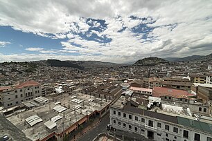
Quito's historic center is among the largest and best-preserved in
History
Pre-Columbian period
The oldest traces of human presence in Quito were excavated by American archeologist Robert E. Bell in 1960, on the slopes of the Ilaló volcano, located between the eastern valleys of Los Chillos and Tumbaco. Hunter-gatherers left tools of obsidian glass, dated to 8000 BC. This archeological site, called EI Inga, was brought to Robert Bell's attention by Allen Graffham. as a geologist in Ecuador, Graffham pursued his amateur interest in archeology. He made surface collections at the site during 1956.[9] The discovery of projectile points, particularly specimens with basal fluting, stimulated his interest, and he made several visits to the site to collect surface materials. Graffham's previous interest in Paleo-Indian remains, and his experience with early human-made materials in Kansas and Nebraska in the Central Plains of the United States, led him to believe that the site was an important discovery.[9]
The second important vestige of human settlement was found in the current neighborhood of Cotocollao (1500 BC), northwest of Quito. The prehistoric village covered over 26 hectares in an area irrigated by many creeks. Near the ancient rectangular houses, there are burials with pottery and stone offerings. The Cotocollao people extracted and exported obsidian to the coastal region.[10]
The priest
By the 20th century, many prominent historians who began more academic studies, doubted the account of the Quitu-Cara kingdom. They think it was a legendary pre-Hispanic account of the highlands.[11][12][13]
These days most historians deny the existence of the kingdom of Quito in favor of a more fragmented region. The Quitu ruled over Quito at the time of the Inca invasion by Topa Inca Yupanqui under the reign of his father.[14] In the early 21st century, there were spectacular new finds of 20-meter deep tombs in the La Florida neighborhood of Quito. Dating to AD 800 they provide evidence of the high quality of craftsmanship among the Quitu, and of the elaborate and complex character of their funerary rites. In 2010 the Museo de Sitio La Florida opened to preserve some of the artifacts from the tombs and explain this complex culture.[15]
Colonial period

On 28 March 1541 Quito was declared a city, and on 23 February 1556 it was given the title Muy Noble y Muy Leal Ciudad de San Francisco de Quito ("Very Noble and Loyal City of San Francisco of Quito"), marking the start of its next phase of

_-_Entrada_en_la_ciudad_de_Quito_de_las_tropas_espanolas_remitidas_por_el_Virrey_del_Per%C3%BA_en_1809_-_Museo_de_Am%C3%A9rica_2010-04-01_(cropped)1.jpg)
,_%C3%B3leo_sobre_lienzo_atribuido_a_Rafael_Salas_Estrada_en_el_MUNA,_Quito.jpg)
The Spanish established
In 1743, after nearly 210 years of Spanish colonization, Quito was a city of about 10,000 inhabitants.[citation needed] Quito briefly proclaimed its de facto independence from Spain between 1765 and 1766 during the Quito Revolt. On 10 August 1809, a movement was again started in Quito to win independence from Spain. On that date a plan for government was unveiled, which appointed Juan Pío Montúfar as president and prominent pro-independence figures in other government positions.
This initial movement was defeated on 2 August 1810, when colonial troops arrived from Lima, Peru, and killed the leaders of the uprising and about 200 other settlers.[citation needed] A chain of conflicts climaxed on 24 May 1822, when Antonio José de Sucre, under the command of Simón Bolívar, led troops into the Battle of Pichincha, on the slopes of the volcano. Their victory established the independence of Quito and the surrounding areas.
Republican Ecuador
In 1833 members of the Society of Free Inhabitants of Quito were assassinated by the government after they conspired against it. On 6 March 1845 the
In 1882 insurgents rose up against the regime of dictator
In 1932 the
21st century
In 2011 the city's population was 2,239,191 people. Since 2002 the city has been renewing its historic center. The old airport, built on filling in a lagoon, was closed to air traffic on 19 February 2013. The area was redeveloped as the "Parque Bicentenario" (Bicentenary Park). The new Mariscal Sucre International Airport, 45 minutes from central Quito, opened to air traffic on 20 February 2013.
During 2003 and 2004, the bus lines of the Metrobus (Ecovia) were constructed, traversing the city from the north to the south.[citation needed] Many avenues and roads were extended and enlarged, depressed passages were constructed, and roads were restructured geometrically to increase the flow of traffic. A new subway system was opened with one line on 1 December 2023.
Geography
Quito is located in the northern
Nearby volcanoes
Quito's closest volcano is
Pichincha is active and being monitored by volcanologists at the Geophysical institute of the
Activity in other nearby volcanoes can also affect the city. In November 2002 the volcano Reventador erupted and showered the city in fine ash particles, to a depth of several centimeters.[25]
The volcanoes on the Central Cordillera (Royal Cordillera), east of Quito, surrounding the Guayllabamba valley, include Cotopaxi, Sincholagua, Antisana and Cayambe. Some of the volcanoes of the Western Cordillera, to the west of the Guayllabamba valley, include Illiniza, Atacazo, and Pululahua (which is the site of the Pululahua Geobotanical Reserve).[26]
Climate
The southern part of Quito has a
Due to its altitude, Quito receives some of the greatest solar radiation in the world, sometimes reaching a UV Index of 24 by solar noon.[29][30]
The fact that Quito lies almost on the equator means that high pressure systems are extremely rare. Pressure is stable, so very low pressure systems are also rare. From 1 July 2010 to 30 June 2011 the lowest pressure recorded was 998.2 hPa (29.48 inHg), and the highest was 1,015.2 hPa (29.98 inHg). Despite the absence of high pressure, Quito can still experience settled weather. Generally, the highest pressure is around midnight and the lowest in the mid-afternoon.[31]
| Climate data for Quito | |||||||||||||
|---|---|---|---|---|---|---|---|---|---|---|---|---|---|
| Month | Jan | Feb | Mar | Apr | May | Jun | Jul | Aug | Sep | Oct | Nov | Dec | Year |
| Record high °C (°F) | 33.0 (91.4) |
28.6 (83.5) |
32.0 (89.6) |
25.6 (78.1) |
30.4 (86.7) |
29.0 (84.2) |
31.0 (87.8) |
27.0 (80.6) |
29.0 (84.2) |
27.0 (80.6) |
29.3 (84.7) |
29.0 (84.2) |
33.0 (91.4) |
| Mean daily maximum °C (°F) | 21.2 (70.2) |
21.0 (69.8) |
20.8 (69.4) |
20.9 (69.6) |
21.0 (69.8) |
21.1 (70.0) |
21.5 (70.7) |
22.2 (72.0) |
22.3 (72.1) |
21.8 (71.2) |
21.3 (70.3) |
21.3 (70.3) |
21.4 (70.5) |
| Daily mean °C (°F) | 15.5 (59.9) |
15.6 (60.1) |
15.5 (59.9) |
15.6 (60.1) |
15.6 (60.1) |
15.5 (59.9) |
15.5 (59.9) |
15.9 (60.6) |
15.9 (60.6) |
15.7 (60.3) |
15.5 (59.9) |
15.5 (59.9) |
15.6 (60.1) |
| Mean daily minimum °C (°F) | 9.8 (49.6) |
10.1 (50.2) |
10.1 (50.2) |
10.2 (50.4) |
10.1 (50.2) |
9.8 (49.6) |
9.4 (48.9) |
9.6 (49.3) |
9.4 (48.9) |
9.5 (49.1) |
9.6 (49.3) |
9.7 (49.5) |
9.8 (49.6) |
| Record low °C (°F) | 3.0 (37.4) |
4.7 (40.5) |
5.1 (41.2) |
5.3 (41.5) |
2.5 (36.5) |
3.0 (37.4) |
3.0 (37.4) |
2.2 (36.0) |
3.4 (38.1) |
4.2 (39.6) |
2.5 (36.5) |
2.5 (36.5) |
2.2 (36.0) |
| Average precipitation mm (inches) | 82.5 (3.25) |
111.0 (4.37) |
146.6 (5.77) |
171.2 (6.74) |
105.5 (4.15) |
39.5 (1.56) |
21.5 (0.85) |
27.7 (1.09) |
68.9 (2.71) |
114.9 (4.52) |
108.5 (4.27) |
100.4 (3.95) |
1,098.2 (43.24) |
| Average precipitation days (≥ 1.0 mm) | 10 | 11 | 15 | 15 | 13 | 7 | 5 | 5 | 11 | 14 | 11 | 11 | 128 |
| Mean monthly sunshine hours | 197 | 140 | 122 | 136 | 164 | 189 | 249 | 256 | 196 | 177 | 197 | 215 | 2,238 |
| Source 1: World Meteorological Organization,[32] (precipitation data),[33] | |||||||||||||
| Source 2: NOAA[34][35] Voodoo Skies (records),[36] Danish Meteorological Institute (sun and relative humidity)[37] | |||||||||||||
| Climate data for Quito | |||||||||||||
|---|---|---|---|---|---|---|---|---|---|---|---|---|---|
| Month | Jan | Feb | Mar | Apr | May | Jun | Jul | Aug | Sep | Oct | Nov | Dec | Year |
| Mean daily daylight hours | 12.0 | 12.0 | 12.0 | 12.0 | 12.0 | 12.0 | 12.0 | 12.0 | 12.0 | 12.0 | 12.0 | 12.0 | 12.0 |
| Average Ultraviolet index | 11+ | 11+ | 11+ | 11+ | 11+ | 11+ | 11+ | 11+ | 11+ | 11+ | 11+ | 11+ | 11 |
| Source: Weather Atlas[38] | |||||||||||||
Topographical zones

Quito is divided into three areas, separated by hills:
- Central: houses the colonial old city.
- Southern: is mainly an industrial and working-class residential area.
- Northern: is the modern Quito, with high-rise buildings, shopping centers, the financial district, and a mix of upper-class, middle-class, and working-class residential areas.
Economy

Quito is the largest city in contribution to national GDP, and the highest in per capita income. Quito has the highest level of tax collection in Ecuador, exceeding the national 57% per year 2009, currently being the most important economic region of the country[citation needed], as the latest "study" conducted by the Central Bank of Ecuador.
The top major industries in Quito includes textiles, metals and agriculture, with major crops for export being coffee, sugar, cacao, rice, bananas and palm oil.[39]
Petroecuador, the largest company in the country and one of the largest in Latin America is headquartered in Quito.[40][verification needed]
Headquarters and regional offices of many national and international financial institutions, oil corporations and international businesses are also located in Quito, making it a world class business city.
In "The World according to
Politics
Governance
Quito is governed by a mayor and a 15-member city council. The mayor is elected to a five-year term and can be re-elected. The position also doubles as Mayor of the Metropolitan District of Quito (the canton). The current mayor is Pabel Muñoz Lopez.
Urban parishes
In Ecuador, cantons are subdivided into parishes, so called because they were originally used by the Catholic Church, but with the secularization and liberalization of the Ecuadorian state, the political parishes were spun off the ones used by the church. Parishes are called urban if they are within the boundaries of the seat (capital) of their corresponding canton, and rural if outside those boundaries. Inside Quito (the city proper), subdivision into urban parishes depends on the organizations that use these parishes (e.g., the municipality, the electoral tribunals, the postal service, the Ecuadorian statistics institute). The urban parishes of different types are not necessarily coterminous nor the same in number or name.
As of 2008[update], the municipality of Quito divided the city into 32 urban parishes. These parishes, which are used by the municipality for administrative purposes, are also known as cabildos[42] since 2001. Since the times of the Metropolitan District of Quito, parishes of this type are also grouped into larger divisions known as municipal zones (zonas municipales). These parishes are as follows:
- Belisario Quevedo
- Carcelén
- Centro Histórico
- Chilibulo
- Chillogallo
- Chimbacalle
- Cochapamba
- Comité del Pueblo
- Concepción
- Cotocollao
- El Condado
- El Inca
- Guamaní
- Iñaquito
- Itchimbía
- Jipijapa
- Kennedy
- La Argelia
- La Ecuatoriana
- La Ferroviaria
- La Libertad
- La Mena
- Magdalena
- Mariscal Sucre
- Ponceano
- Puengasí
- Quitumbe
- Rumipamba
- San Bartolo
- San Juan
- Solanda
- Turubamba
Ecclesiastical parishes
The Roman Catholic Archdiocese of Quito divides the city into 167 parishes, which are grouped into 17 zones.[43]
Transport
Public transport
The
In August 2012 the
In March 2023, a new bicycle sharing system was established in order to promote the bicycle as a sustainable, healthy and fast mean of transport. With this service, the objective is to reduce mobilization times, air pollution and improve the quality of life of the citizens.[48]Highways
Although public transport is the primary form of travel in the city, including fleets of taxis that continually cruise the roadways, the use of private vehicles has increased substantially during the past decade.[49] Because of growing road congestion in many areas, there were plans to construct a light rail system, which were conceived to replace the northern portion of the Trole.[50] These plans have been ruled out and replaced by the construction of the first metro line (subway) in 2012. It started to operate in December 2023, joining the existing public transportation network.[51]
Roads, avenues and streets
Because Quito is about 40 km (25 mi) long and 5 km (3.1 mi) at its widest, most of the important avenues of the city extend from north to south. The two main motorways that go from the northern part of the city to the southern are Avenue Oriental (Corridor Periférico Oriental) on the eastern hills that border the city, and Avenue Occidental on the western side of the city on the Pichincha volcano. The street 10 de Agosto also runs north to south through most of the city, running down the middle of it. The historic center of the city is based on a grid pattern, despite the hills, with the streets Venezuela, Chile, García Moreno, and Guayaquil being the most important.
Aviation

The Mariscal Sucre International Airport serves as the city's principal airport for passenger travel and freight. The airport is located 18 km (11 mi) east of the city's center in the Tababela parish. It began operations on 20 February 2013, replacing the Old Mariscal Sucre International Airport located 10 km (6.2 mi) north of the city center within city limits. The old airport was replaced due to tall buildings and nighttime fog that made landing from the south difficult. The old airport was converted into a metropolitan park.
Railways
There is a railroad that goes through the southern part of Quito and passes through the Estación de Chimbacalle. It is managed by the Empresa de Ferrocarriles Ecuatorianos (EFE). This form of transportation is nowadays used mostly for tourism.
Metro
A 23 km (14 mi) metro subway system (Quito Metro) began construction with Phase One begun in 2013, entailed the construction of stations at La Magdalena and El Labrador. Phase Two, begun in 2016, involves 15 stations, a depot and sub-systems. The project is expected to carry 400,000 passengers per day and to cost $1.5 billion[52] with financing coming from the World Bank, the Inter-American Development Bank (IDB), the European Investment Bank (EIB) and the Development Bank of Latin America (CAF)[53] and the line opened on Dic 1, 2023.[54][55][56]
Points of interest
Historic center

Quito has the largest, least-altered, and best-preserved historic center in
- Palacio de Carondelet
- Basílica del Voto Nacional
The monumental
- Quito Metropolitan Cathedral
The Quito Metropolitan Cathedral, is one of the largest religious symbols of spiritual value for the Catholic community in the city. Construction of this church began in 1535, seventeen years after the Diocese of Quito was created in 1545. The church building was completed in 1799, during the administration of President of the Real Audiencia, Baron Héctor de Carondelet.[citation needed]
One of the major events that took place in this cathedral was the murder of the Bishop of Quito, José Ignacio Checa y Barba, who during the mass of
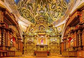
- Church of La Compañía de Jesús
Construction of The
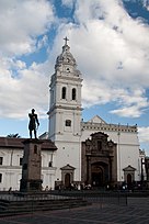
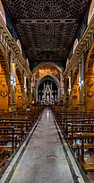
- Basilica of San Francisco
The Basilica of San Francisco is the largest of the existing architectural ensembles in the historic centers of cities in Latin America. The construction of the church began in 1550, on land adjacent to the plaza where the Native Americans engaged in the barter of products.
- Church of El Sagrario
In colonial times, the
- Church of Santo Domingo
Church of Santo Domingo. Although they arrived in Quito in 1541, the Dominicans started to build their own temple in 1580, using the plans of Francisco Becerra, and under his direction. The work was completed in the first half of the 17th century. Inside the church are valuable structures, such as the neo-Gothic main altar. This was installed in the late 19th century by Italian Dominicans. The roof of the Mudéjar style church features paintings of martyrs of the Order of Saint Dominic. The roof of the nave is supported by a pair-and-knuckle frame, decorated inside by tracery. In the museum on the north side of the lower cloister, there are wonderful pieces by great Quito sculptors such as the Saint Dominic de Guzmán by Father Carlos, the Saint John of God by Caspicara, and the Saint Thomas Aquinas by Legarda. Another Baroque masterpiece that still stands today, is the Chapel of Nuestra Señora del Rosario, a recognizable architectural icon of Quito. This chapel was built next to the church. The largest fraternity in the city of Quito was founded in this chapel.
-
 Carondelet Palace, office and house of the Presidents of Ecuador.
 -
 Quito Metropolitan Cathedral, built between 1535 and 1799.
 -
 Church of La Compañía de Jesús
 -

-
 Basilica of San Francisco, built between 1535 and 1650.
 -
 Interior of the basilica of San Francisco
 -
 View of the Church of Santo Domingo
 -
 Interior of the church of Santo Domingo
 -
 Chapel of the Rosary within the church of Santo Domingo
 -
 Gangotena Palace
 -
 Municipal Palace in the Plaza Grande
 -
 Plaza Grande
 -
 Centro de Arte Contemporáneo, Quito.
 -
 Antiguo Hospital Militar (Centro Histórico, Quito)
 -
 View of Quito from Basílica del Voto Nacional
 -
 Virgin of El Panecillo
 -
 Cemetery of San Diego, Quito

.jpg)


_pic_a05.JPG)


El Panecillo

La Mariscal
This modern area is considered to be the city's entertainment hub. It is a meeting point for both local residents and tourists. Its cosmopolitan atmosphere is expressed in a wide variety of culinary, artistic, and cultural options, and the large number of hotels, inns, travel agencies, shops, bars, and discothèques that light up when the sun sets.[57] El Gran Desfile de Mariscal (the Great Parade of Mariscal) is held in this area during the Fiestas de Quito.[58]
Plaza Foch (La Zona)

This area is considered to be the zona rosa of the city. It hosts various night clubs and bars, and has a great night vibe, complete with street vendors selling gum, cigarettes and other small items. Plaza Foch is heavily frequented from Thursday to Saturday, and draws tourists from all over the world. For this reason, prices for liquor, beer and food are expensive compared to other places in Quito. Due to its small driveways and big sidewalks, it's mostly a pedestrian area.
Parks
Metropolitano
Parque Metropolitano Guanguiltagua
Bicentenario
Parque Bicentenario is the second largest urban park in Quito (surpassed only by the Parque Metropolitano), located in the site of the Old Mariscal Sucre International Airport. It was inaugurated on 27 April 2013. This park has 200 acres (81 ha), and it is located at 2,800 m (9,186 ft), above mean sea level. The former runway has been converted into recreational space with lanes painted for bicycles and pedestrians. There are play structures and games for children. As well, there is outdoor exercise equipment for adults. The park contains a man-made pond and more than one thousand trees, many newly planted. The park also hosts cultural exhibits and outdoor concerts.
La Carolina

El Ejido
El Ejido
Guápulo
Set on the side on a cliff with González Suárez Street, one of the most famous in Quito and to the other side the valley and further in the distance, the Amazon Jungle. Guápulo is a district of Quito, Ecuador, also called an electoral parish (parroquia electoral urbana). The parish was established as a result of the October 2004 political elections when the city was divided into 19 urban electoral parishes.[64] Set behind Hotel Quito, the neighborhood of Guápulo runs down the winding Camino de Orellana, from González Suárez to Calle de los Conquistadores, the main road out of Quito and to the neighboring suburbs.[65][66] Often considered an artsy, bohemian neighborhood of Quito, Guápulo is home to many local artists and a couple of hippy cafés/bars. Every year on 7 September the guapuleños honor their neighborhood with the Fiestas de Guápulo, a fantastic celebration complete with costumes, parade, food, drink, song, dance, and fireworks.
La Alameda
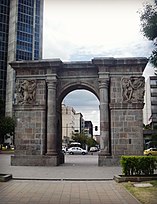
The long triangular La Alameda is located at the beginning of street Guayaquil, where the historic center begins. It has an impressive monument of Simón Bolívar at the apex. There are several other interesting monuments in this park. In the center of the park is the Quito Observatory, which was opened by President García Moreno in 1873. It is used for both meteorology and astronomy. At the north end of the park are two ornamental lakes, where rowboats can be rented.
La Floresta
One of the most iconic neighborhoods in the city, with an important cultural and gastronomic offer. The neighborhood has local and international restaurants, a cinema, small theaters, cafes, bars, museums and coworking spaces.
-
 La Circasiana door, currently at the north end of El Ejido park. Originally the entrance door to the Circasiana Palace in La Mariscal neighborhood.
 -
 Astronomic observatory in the Alameda park
 -
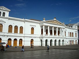 Sucre National Theatre


TeleferiQo

The Aerial tramway Station at Cruz Loma (part of the Pichincha mountain complex at about 4,000 m (13,000 ft)). Since July 2005, Quito has had an aerial tramway, known as the "Telefériqo", from the city center to the hill known as Cruz Loma on the east side of the Pichincha volcano. The ride takes visitors to an elevation of about 4,100 m (13,500 ft). There are also trails for hiking and areas where pictures can be taken of Quito. Because of the increased elevation and the wind on the mountain, it is considerably cooler.
Besides the aerial tramway to Cruz Loma, the
Outside the city

La Mitad del Mundo[67] (the middle of the world) is a small village administered by the prefecture of the province of Pichincha, 35 km (22 mi) north of Quito. It has since been determined, with the use of Global Positioning System technology, that the actual equator is some 240 m (790 ft) north of the monument area. Nearby is the Intiñan Solar Museum, which may be closer to the true equator.[68] The Intiñan Solar Museum provides a demonstration which purports to show the Coriolis force causing a clockwise rotation of sink water a few meters south of the equator and a counterclockwise rotation a few meters north,[69] but many scientific sources claim that this is implausible.[70][71][72][73][74]
Pululahua Geobotanical Reserve, located a few miles northwest from La Mitad del Mundo, contains the Pululahua volcano, whose caldera (crater) is visible from a spot easily accessible by car. It is believed to be one of only a few in the world with human inhabitants.
Quito Zoo,[75] located near the rural parish of Guayllabamba, about 20 km (12 mi) outside Quito, has the biggest collection of native fauna in Ecuador, including several kinds of animals that are sometimes targeted in Ecuador in the illegal fur trade. The Zoo works in conservation and education in Ecuador and has successfully bred the endangered Andean condor.
Maquipucuna Reserve is located in Quito's rural parish of Nanegal. This 14,000 acre high biodiversity rainforest and cloud forest reserve protects over 1966 species of plants[76] (10% of Ecuador's plant diversity) and close to 400 bird species. This reserve, which is surrounded by a 34,000 acre protected forest, was declared an IBA (Important Bird Area) in 2005[77] and is the core of the conservation corridor for the spectacled bear (Andean bear) declared in 2013.[78] The area has an ecolodge located in the northern end of the Reserve where the spectacled bear can be sighted for about two months every year.
Some of the other nearby natural attractions are:
- Maquipucuna Reserve Conservation, community projects, bird watching, spectacled bear watching
- Bellavista Cloud Forest Reserve conservation and bird watching lodge
- Cayambe – Coca Ecological Reserve
- Papallacta & Oyacachi thermal springs
- Cotopaxi National Park
- Mindo Nambillo cloud forest
- Illiniza volcano
- Pasochoa Wildlife Refuge
- Pichincha volcanowith its peaks Wawa Pichincha and Ruku Pichincha
Culture
Quito is a city with a mix of modern-day and traditional culture. There is a large
Education
.jpg)
Universities
According to the National Council for Higher Education of Ecuador (CONESUP), these are the universities founded in or around Quito before 2006:[80]
| University | Foundation Date |
|---|---|
| Central University of Ecuador | 18 March 1826 |
| National Polytechnic School | 27 August 1869 |
| Pontifical Catholic University of Ecuador | 4 November 1946 |
| Universidad San Francisco de Quito | 25 October 1988 |
| Instituto de Altos Estudios Nacionales | 20 June 1972 |
Facultad Latinoamericana de Ciencias Sociales
|
16 December 1974 |
| Universidad de las Fuerzas Armadas – ESPE | 8 December 1977 |
Universidad Tecnológica Equinoccial
|
18 February 1986 |
| Universidad Andina Simon Bolivar | 27 January 1992 |
| International SEK | 30 June 1993 |
| Universidad de las Américas | 29 November 1995 |
| Universidad Internacional del Ecuador | 30 August 1996 |
Universidad Del Pacifico: Escuela de Negocios
|
18 December 1997 |
| Universidad de Especialidade Turisticas | 31 March 2000 |
| Universidad de los Hemisferios | 20 May 2004 |
| Universidad Politécnica Salesiana | 5 August 1994 |
Libraries
One of the oldest and most important library in Ecuador is the Central University Library in Quito. It was founded in 1586 and has 170,000 volumes in its possession.[81] The Aurelio Espinoza Polit in Cotocollao, Casas de la Cultura and Catholic University are also important ones.
Museums

- National Museum of Ecuador – This art museum houses five displays. Each covers a different time period, ranging from prehistory to modern Ecuador.[82]
- Museo de Arte Contemporaneas – Located north of Basilica del Voto Nacional, this museum has permanent and temporary exhibitions. The historic building used to be a military hospital and was renovated for its new purpose.
- Casa del Alabado – Located just south of Plaza San Francisco, this is the Old Town's newest museum and houses a collection of pre-colonial art. The building is one of the oldest houses in the city.
- Museo de la Ciudad – A museum dedicated to the history of Quito. Located just east of the Plaza de Santo Domingo,[83] it is housed in the buildings of the former San Juan de Dios Hospital, a UNESCO Cultural World Heritage Site.
- La Capilla del Hombre – A museum showcasing the work of legendary Ecuadorian Artist Oswaldo Guayasamín
- Ecuador National Museum of Medicine – A museum dedicated to the history of medicine[84] in Quito, founded by Eduardo Estrella Aguirre. Estrella was in the Archives of the Royal Botanical Gardens in Madrid, Spain in 1985 and uncovered the lost papers and paintings documenting one of the first expeditions to South America. In Madrid Spain, Estrella worked for many years and documented his observations in the archive and was able to publish the extensive work of Juan Tafalla in a book called Flora Huayaquilensis.
- Museum House of Sucre – This museum is dedicated to life of Mariscal Antonio José de Sucre, a hero of Ecuadorian independence. The ground floor has an array of weapons and military relics, many of which belonged to Sucre himself. The second floor has been restored to what it might have looked like in Sucre's time.[85]
.jpg)

.JPG)
Sports
.jpg)
Quito is home to prominent football clubs in the country. The city's top clubs (
The professional teams in the city are:
- América de Quito
- Aucas
- Deportivo Quito
- El Nacional
- LDU Quito
- Universidad Católica
One of the more interesting facts of Quito is that the stadiums are located over 2,800 m (9,200 ft)
Crime
The
Notable people
- Jorge Carrera Andrade, poet (1902–1978)
- Christian Benitez, professional footballer (1986–2013)
- Sebastián Cordero, film director (b. 1972)
- Juan Manuel Correa, racing driver (b. 1999)
- Eugenio Espejo, scientist (1747–1795)
- Oswaldo Guayasamín, painter (1919–1999)
- Jorge Icaza, novelist (1906–1978)
- Juana Miranda, midwife and professor (1842–1914)
- Mariana de Jesús de Paredes, Catholic saint (1618–1645)
- Manuela Saenz, revolutionary (1797–1856)
- Byron Sigcho-Lopez, politician and community activist (b. 1983)
- Teodelinda Terán Hicks, cellist (1889–1959)
- Christian Zurita, journalist (b. 1970)
Twin towns – sister cities
Quito is twinned with:
 Bogotá, Colombia[89]
 Cádiz, Spain[90]
 Doha, Qatar[91]
 Guangzhou, China[92]
 Guarulhos, Brazil[93]
 Kraków, Poland[94]
 Lima, Peru[95]
 Louisville, United States[96]
- Madrid, Spain[97]
 Managua, Nicaragua[98]
- Medellín, Colombia[99]
 Mexico City, Mexico[100]
 La Paz, Bolivia[101]
 Taipei, Taiwan[102]
 Asunción, Paraguay[103]
See also
- List of buildings in Quito
- List of cities in Ecuador
- Pichincha Province
- Metropolitan District of Quito
- Ciudad Mitad del Mundo
References
- ^ , Encyclopædia Britannica, vol. VII (9th ed.), New York: Charles Scribner's Sons, 1878, p. 649
- ^ Citypopulation.de Population and area of Quito
- ^ "TelluBase—Ecuador Fact Sheet (Tellusant Public Service Series)" (PDF). Tellusant. Retrieved 11 January 2024.
- ^ "Guagua Pichincha". Instituto Geofísico, Escuela Politécnica Nacional. 27 April 2022.
- ^ "Contact Us." TAME. Retrieved on 14 March 2010.
- ^ La Paz is the administrative capital of Bolivia and is higher than Quito while Sucre is the constitutional capital of Bolivia and is lower than Quito.
- ^ "Encuentran indicios de los primeros habitantes de Quito, Ecuador". Red Historia (in Spanish). 16 November 2019. Retrieved 28 April 2022.
- ^ a b c "City of Quito – UNESCO World Heritage". Whc.unesco.org. Retrieved 30 April 2010.
- ^ a b "Robert E. Bell Archaeological Investigation at the Site of EI Inga, Ecuador | Sam Noble Museum". Sam Noble Museum. 6 February 2015. Retrieved 30 June 2017.
- ^ Lleras, Roberto. The Cambridge Prehistory of Ecuador, Colombia and Venezuela.
- ^ Rostworowski, María. History of the Inca Realm. Translated by Iceland, Harry B. Cambridge University Press.
- ^ Porras Barrenechea, Raúl. Los cronistas del Perú.
- ^ González Suárez, Federico. Historia General del Ecuador.
- ^ Cabello de Balboa, Miguel. Miscelánea antártica.
- ^ "El Telégrafo".
- ^ Guamán Poma (1615). "Guaman Poma, Nueva corónica y buen gobierno (1615)". Royal Library, Denmark website. p. 1011.
- ^ "City" (in Spanish). Quito Distrito Metropolitano. Archived from the original on 13 October 2017. Retrieved 2 August 2008.
- Wikidata Q111319599.
- ISBN 0-7864-2066-9.
- ^ "Episode 200: We Interrupt This Program (11.4.2022)". Criminal. 4 November 2022. Retrieved 22 November 2022.
- ^ "Quito Ecuador Travel Guide – Altitude, Hotels, Airport, Tours". ecuadorexplorer.com. 10 January 2013. Retrieved 22 November 2016.
- ^ Chris Beall. "Ecuador's top 10 volcanic experiences – travel tips and articles". Lonely Planet. Retrieved 12 March 2013.
- ^
Naumova, En; Yepes, H; Griffiths, Jk; Sempértegui, F; Khurana, G; Jagai, Js; Játiva, E; Estrella, B (July 2007). "Guagua Pichincha". Environmental Health. 6 (1). National Environmental Satellite, Data, and Information Service: 21. PMID 17650330.
- ^ "Guagua Pichincha". Operational Significant Event Imagery. National Oceanic and Atmospheric Administration. Archived from the original on 15 September 2008. Retrieved 28 March 2013.
- ^ Le Pennec, J-L.; et al. (2006), "Characteristics and impacts of recent ash falls produced by Tungurahua and El Reventador volcanoes, Ecuador", Fourth Conference, Cities on Volcanoes (PDF), archived from the original (PDF) on 30 October 2008
- ^ "Geography". Retrieved 29 March 2013.
- ^ "Weather". Sitio Oficial Turístico de Quito. Archived from the original on 19 July 2011. Retrieved 2 August 2008.
- ^ "Average weather for Quito". The Weather Channel. Retrieved 2 August 2008.
- ^ "Radiación UV nociva en Guayaquil y Quito". www.eluniverso.com. El gran Guayaquil. 23 October 2008. Retrieved 29 September 2014.
- ^ "Alertan sobre rayos UV en Quito". www.metroecuador.com. Metro Ecuador. Archived from the original on 6 October 2014. Retrieved 29 September 2014.
- ^ "Yanahuaico Weather – Personal Weather Station: IPICHINC3 by Wunderground.com – Weather Underground". wunderground.com.
- ^ "World Weather Information Service – Guayaquil". Met Office. Retrieved 16 January 2016.
- ^ "World Weather Information Service – Quito". World Meteorological Organization. Retrieved 2 March 2013.
- ^ "WMO Normals – Guayaquil". NOAA. Retrieved 16 January 2016.
- ^ "Quito Mariscal Sucre". World Weather Records 9th Series 1991–2000. NOAA. Retrieved 2 March 2013.
- ^ "Quito Monthly Temperature weather history". Voodoo Skies. Retrieved 21 November 2014.
- ^ Cappelen, John; Jensen, Jens. "Ecudaor – Quito" (PDF). Climate Data for Selected Stations (1931–1960) (in Danish). Danish Meteorological Institute. p. 81. Archived from the original (PDF) on 16 January 2013. Retrieved 2 March 2013.
- ^ "Quito, Ecuador – Monthly weather forecast and Climate data". Weather Atlas. Retrieved 25 January 2019.
- ^ "Working in Quito". internations.org. Archived from the original on 14 November 2016. Retrieved 22 November 2016.
- ^ "Contacto" (in Spanish). Petroecuador. Archived from the original on 7 February 2016. Retrieved 4 February 2016.
- ^ "GaWC – The World According to GaWC". www.lboro.ac.uk. Retrieved 5 February 2016.
- ^ "Diccionario. Cabildo (Parroquias)". quito.gob.ec. Retrieved 8 July 2009.[permanent dead link]
- ^ "Parroquias de Quito". Arquidiocesisdequito.org. Archived from the original on 8 March 2009. Retrieved 8 July 2009.
- ^ "Sistema Convencional de Transporte" (PDF) (in Spanish). Metrobús Quito. Archived from the original (PDF) on 10 September 2008. Retrieved 4 August 2008.
- ^ "BiciQ Bicicleta Pública" (in Spanish). BiciQ. Archived from the original on 18 September 2013. Retrieved 13 September 2013.
- ^ "Bici Q: 1.078 carnetizados". La Hora – Nacional (in Spanish). Quito, Ecuador: La Hora. 31 August 2012. Retrieved 13 September 2013.
- ^ "La bici pública rodará desde el martes". El Comercio.com (in Spanish). Quito: Grupo El Comercio. 27 July 2012. Archived from the original on 28 July 2013. Retrieved 13 September 2013.
- ^ "SBP Quito" (in Spanish). Retrieved 20 October 2023.
- ^ "Cars are besieging Quito". El Comercio (in Spanish). Archived from the original on 27 September 2007. Retrieved 4 August 2008.
- ^ "TRAQ – Tren Rápido de Quito" (PDF) (in Spanish). Archived from the original (PDF) on 28 February 2007.
- ^ Carvajal, Ana (24 May 2019). "El Metro entrará a operar entre marzo y abril del 2020". El Comercio. Retrieved 16 June 2019.
- ^ Osava, Mario (30 November 2016). "Subway Will Modernise – and Further Gentrify – Historic Centre of Quito". Inter Press Service. Retrieved 21 December 2016.
- ^ "World bank backs Metro Quito construction". GlobalRailNews. 4 August 2013.
- ^ Salazar, Paul (5 December 2016). "The Economic Recovery of Quito Takes the Subway". Working for a World Free of Poverty. World Bank. Retrieved 21 December 2016.
- ^ "Operación del Metro de Quito ahora se prevé para junio del 2022". El Comercio. 30 June 2021. Retrieved 6 July 2021.
- ^ Artymiuk, Simon (5 May 2023). "Revenue services begin on Quito Metro Line 1". IRJ. Retrieved 11 May 2023.
- ^ The Great Guide Quito
- ^ "Fiestas de Quito 2022: Fechas y horario del Gran desfile de La Mariscal". El Universo (in Spanish). 2 December 2022. Retrieved 12 December 2022.
- ^ "Parque Metropolitano Guanguiltagua" (in Spanish). Archived from the original on 23 February 2009.
- ^ "Sitio Oficial Turístico de Quito – Parque La Carolina". Quito.com.ec. Archived from the original on 27 November 2010. Retrieved 8 July 2009.
- ^ "Pope John Paul II, landing in Ecuador during a..." UPI. Retrieved 15 November 2022.
- ^ "Sitio Oficial Turístico de Quito – Parque El Ejido". Quito.com.ec. Archived from the original on 5 September 2013. Retrieved 8 July 2009.
- ^ "Guayasamin.com". Archived from the original on 8 March 2005.
- ^ "Quito". Lonely Planet. Archived from the original on 29 September 2008. Retrieved 31 October 2015.
- ^ Reserved., Copyright (c) 2006–2011 METAMORF S.A. All Rights. "Guápulo, Guápulo Local Guide: Top rated Activities, Trips and Travel Tips for Guápulo, V!VA Travel Guides". vivatravelguides.com.
{{cite web}}: CS1 maint: numeric names: authors list (link) - ^ "Arts and Crafts in Guapulo". Archived from the original on 28 January 2010.
- ^ "Welcome to Mitad del Mundo". GoEcuador.com. Archived from the original on 4 December 2004.
- ^ "Intiñan Solar Museum". Home of the "true" equator. Atlas Obscura. Retrieved 21 December 2016.
- ^ Archived at Ghostarchive and the Wayback Machine: TheLazyInvestor. "Ecuador At The Equator – Water Demonstration – Coriolis Effect". YouTube. Retrieved 21 December 2016.
- ^ "Bad Coriolis". Retrieved 21 December 2016.
- ^ "Flush Bosh". 28 April 2003. Retrieved 21 December 2016.
- ^ "Does the rotation of the Earth affect toilets and baseball games?". 20 July 2009. Retrieved 21 December 2016.
- ^ "Can somebody finally settle this question: Does water flowing down a drain spin in different directions depending on which hemisphere you're in? And if so, why?". Scientific American. Retrieved 21 December 2016.
- ^ "Can You Detect The Coriolis Effect in your Sink?". 18 December 2005. Retrieved 21 December 2016.[permanent dead link]
- ^ "Quito Zoo". Quito Zoo. Archived from the original on 21 May 2012. Retrieved 21 May 2012.
- ^ "Maquipucuna Florula". ucdavis.edu.
- ^ "BirdLife Data Zone". birdlife.org.
- ^ Conservation Corridor Resolution
- ^ "Ecuador's Cultural Events & Festivals – Your Escape to Ecuador". yourescapetoecuador.com. Archived from the original on 28 June 2013. Retrieved 22 November 2016.
- ^ "Consejo Nacional de Educación Superior del Ecuador". Conesup.net. Archived from the original on 11 June 2010. Retrieved 30 April 2010.
- ^ "Libraries and museums – Ecuador". nationsencyclopedia.com. Retrieved 22 November 2016.
- ^ "Banco Central del Ecuador". Bce.fin.ec. Archived from the original on 5 September 2009. Retrieved 30 April 2010.
- ^ "Museo de la Ciudad:: Quito Ecuador" (in Spanish). Museociudadquito.gov.ec. Archived from the original on 29 April 2010. Retrieved 30 April 2010.
- ^ "Ecuador Terra Incognita – La Flora Huayaquilensis". Terraecuador.net. 14 February 2004. Retrieved 15 September 2011.
- ^ "Quito Official Travel Information Site – Ecuador – Sucre House-Museum". Quito.com.ec. Archived from the original on 19 July 2011. Retrieved 30 April 2010.
- ^ "Quito Sports". studylanguages.org. Archived from the original on 5 March 2017. Retrieved 22 November 2016.
- ^ Thyberg, David. "Is It Safe for Americans to Travel to Quito Ecuador?". USA Today. Archived from the original on 4 October 2015.
- ^ "Ecuador 2015 Crime and Safety Report". OSAC. 4 June 2015.
- ^ "Cabildos de Quito y Bogotá aumentan la cooperación". eltelegrafo.com.ec (in Spanish). El Telégrafo. 15 February 2012. Retrieved 17 December 2021.
- ^ "Quito y Cádiz firman Hermanamiento y estrechan lazos de cooperación". quitoinforma.gob.ec (in Spanish). Quito Informa. 8 November 2018. Retrieved 17 December 2021.
- ^ "Quito y Doha firman acuerdo de hermanamiento". quitoinforma.gob.ec (in Spanish). Quito Informa. 3 October 2018. Retrieved 17 December 2021.
- ^ "Sister Cities". eguangzhou.gov.cn. Guangzhou. Retrieved 17 December 2021.
- ^ "Cooperação Internacional". guarulhos.sp.gov.br (in Portuguese). Guarulhos. Retrieved 17 December 2021.
- ^ "Współpraca międzynarodowa z miastami zagranicznymi". bip.krakow.pl (in Polish). Biuletyn informacji publicznej miasta Krakowa. Retrieved 17 December 2021.
- ^ "Información de Gobierno". proyectoallas.net (in Spanish). AL-LAs. 2 January 2014. Retrieved 18 December 2021.
- ^ "Home". sclou.org. Sister Cities of Louisville. Archived from the original on 30 September 2020. Retrieved 17 December 2021.
- ^ "Agreements with cities". madrid.es. Madrid. Retrieved 16 December 2021.
- ^ "Condecoración al embajador del Ecuador Antonio Preciado Bedoya". bolsadenoticias.com.ni (in Spanish). Bolsa de Noticias. 31 July 2013. Retrieved 17 December 2021.
- ^ "Medellín is Puerto Morelos' first twin city". acimedellin.org. ACI Medellín. 6 August 2019. Retrieved 17 December 2021.
- ^ "Acuerdos interinstitucionales registrados por dependencias y municipios de Ciudad de México". sre.gob.mx (in Spanish). Secretaría de relaciones exteriores. Retrieved 17 December 2021.
- ^ "Hermanamientos". lapaz.bo (in Spanish). La Paz. Archived from the original on 14 December 2021. Retrieved 17 December 2021.
- ^ "International Sister Cities". tcc.gov.tw. Taipei City Council. Retrieved 17 December 2021.
- ^ "Asunción y Quito restablecerán hermanamiento conjunto". asuncion.gov.py. Asunción. 17 March 2016. Retrieved 16 December 2021.
Bibliography
External links
- . Encyclopædia Britannica. Vol. 22 (11th ed.). 1911.
- Explore the City of Quito in the UNESCO collection on Google Arts and Culture
Provincial capitals in Ecuador | ||
|---|---|---|
Within regions, north to south | ||
| Insular |  | |
| Costa | ||
| Sierra | ||
| Oriente | ||

| International | |
|---|---|
| National | |
| Geographic | |
| Other | |