Hodeng-au-Bosc
Source: Wikipedia, the free encyclopedia.
Commune in Normandy, France
Hodeng-au-Bosc | |
|---|---|
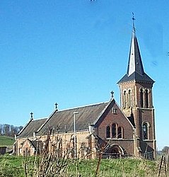
 The church in Hodeng-au-Bosc | |
| Coordinates: 49°51′46″N 1°42′30″E / 49.8628°N 1.7083°E / 49.8628; 1.7083 | |
| Country | France |
| Region | Normandy |
| Department | Seine-Maritime |
| Arrondissement | Dieppe |
| Canton | Eu |
| Intercommunality | CC Aumale - Blangy-sur-Bresle |
| Government | |
| • Mayor (2020–2026) | Claude Santerre[1] |
| Area 1 | 8.77 km2 (3.39 sq mi) |
| Population (2021)[2] | 572 |
| • Density | 65/km2 (170/sq mi) |
| Time zone | UTC+01:00 (CET) |
| • Summer (DST) | UTC+02:00 (CEST) |
| INSEE/Postal code | 76363 /76340 |
| Elevation | 61–205 m (200–673 ft) (avg. 100 m or 330 ft) |
| 1 French Land Register data, which excludes lakes, ponds, glaciers > 1 km2 (0.386 sq mi or 247 acres) and river estuaries. | |
Hodeng-au-Bosc (French pronunciation: [ɔdɑ̃ o bɔsk]) is a commune in the Seine-Maritime department in the Normandy region of northern France.
Geography
A
glassmaking
factory, founded in 1623.
Population
| Year | Pop. | ±% p.a. |
|---|---|---|
| 1968 | 444 | — |
| 1975 | 507 | +1.91% |
| 1982 | 541 | +0.93% |
| 1990 | 576 | +0.79% |
| 1999 | 555 | −0.41% |
| 2007 | 591 | +0.79% |
| 2012 | 568 | −0.79% |
| 2017 | 575 | +0.25% |
| Source: INSEE[3] | ||
Places of interest
- The church of St. Denis, dating from the nineteenth century.
- The church of St.Sauveur at Guimerville, dating from the sixteenth century.
People
Jean-Luc Thérier, racing driver for the Alpine Renault team in the 1970s, was born here in 1945.
See also
References
- ^ "Répertoire national des élus: les maires". data.gouv.fr, Plateforme ouverte des données publiques françaises (in French). 2 December 2020.
- ^ "Populations légales 2021". The National Institute of Statistics and Economic Studies. 28 December 2023.
- ^ Population en historique depuis 1968, INSEE
Wikimedia Commons has media related to Hodeng-au-Bosc.
| Authority control databases: National |
|---|


