
Hohokam

Hohokam (
The origin of the culture is debated. Most archaeologists either argue it emerged locally or in
In modern-day
According to the
There are several official spelling variants for the name, including Hobokam, Huhugam, and Huhukam. The spellings are commonly thought to be interchangeable, but they have different meanings. In the 1930s, archaeologist Harold S. Gladwin differentiated Hohokam culture from others in the region. He applied the existing O'odham term for the culture, huhu-kam, in its common mistranslation as "all used up"[5] or "those who are gone",[6] to classify the remains that he was excavating in the Lower Gila Valley. Similarly, in the 1970s, archaeologist Hardy translated the O'odham word huhugam to mean "that which has perished." However, huhugam refers to past human life and not to objects such as ruins. Therefore, the archaeological term Hohokam should not be confused with huhugam, the reverence of ancestors and descendants.[7][8]
Overview

Hohokam society is primarily associated with the Gila and lower Salt River drainages[9] in the Phoenix basin.
The Phoenix Basin was the Hohokam Core Area, and the Hohokam Periphery were adjacent areas where the Hohokam culture extended. Collectively, the Core and Peripheries formed the greater Hohokam Regional System, which occupied the northern or Upper Sonoran Desert in Arizona. The Hohokam also extended into the Mogollon Rim.
The Hohokam Core was located along rivers, and as such inhabited a prime trade position. Trade occurred between the Patayan, who were situated along the Lower Colorado River and in southern California; the Trincheras of Sonora, Mexico; the Mogollon culture in Eastern Arizona; Southwest New Mexico; Northwest Chihuahua, Mexico; and the Ancestral Puebloans in Northern Arizona.[10] From 900 to 1150 CE, neighboring Chaco society encouraged trade throughout northern Arizona and into southwest Colorado and southern Utah.[11] These trade networks increased hand-to-hand trade throughout the region, with goods traveling throughout the Colorado Plateau, northern Arizona, and the Phoenix area.[3]
Hohokam irrigation systems supported the largest population in the Southwest by 1300 CE.[12] Archaeologists working at a major archaeological dig in the 1990s in the Tucson Basin, along the Santa Cruz River, identified a culture and people that may have been the ancestors of the Hohokam.[13] This prehistoric group may have occupied southern Arizona as early as 2000 BCE, and in the Early Agricultural Period grew corn, lived year-round in sedentary villages, and developed sophisticated irrigation canals.[12]
The Hohokam used the waters of the Salt and Gila Rivers to build an assortment of simple canals with weirs for agriculture. From 800 to 1400 CE,[14] their irrigation networks rivaled the complexity of those of ancient Near East, Egypt, and China. They were constructed using relatively simple tools and engineering technology, yet achieved drops of a few feet per mile, balancing erosion and siltation.[15] The Hohokam cultivated varieties of cotton, tobacco, maize, beans, and squash, and harvested a vast variety of wild plants. Late in the Hohokam Chronological Sequence, they also used extensive dry-farming systems, mainly to grow agave for food and fiber. Their agricultural strategies were vital in the inhospitable desert, and allowed the aggregation of rural populations into complex urban centers.[16]
Many features of earlier Hohokam domestic architecture, such as rectangular pithouses, were apparently transplanted relatively intact from the Tucson basin during the early Formative Period. Throughout the Hohokam Chronological Sequence, individual homes were usually excavated approximately 40 cm (16 in) below ground level, had plastered or compacted floors of 12 to 35 m2, and had a bowl-shaped, clay-lined hearth near the wall-entry. By 600 CE, a distinct Hohokam architectural tradition emerged that had similarities with Mesoamerica, such as ballcourts that also served as neighborhood gathering and trade spaces. By 1150 CE, pithouses were replaced by above-ground structures in the compound style with central courtyards. By 1200 CE, rectangular platforms mounds were being constructed.[17]
Hohokam burial practices varied over time, but cremation was a defining cultural characteristic of the Hohokam Core. Cremation has been used by archaeologists to suggest cultural interaction through trade or immigration with neighboring communities. An example is the Mogollan, at the Continental site in Tucson.[18] Initially, the main method was flexed inhumation, similar to the southern Mogollon culture neighboring to the east. By the late Formative and Preclassic periods, the Hohokam cremated their dead, very similar to the traditions documented among the historic Patayan culture to the west along the Lower Colorado River. Although the particulars of the practice changed somewhat, cremation remained the main practice in Hohokam until around 1300 CE.
History
Hohokam chronological sequence (HCS) is an archaeological construct that divides Hohokam history into phases of significant cultural changes. It uses two main methods of expression: Gladwinian and Cultural Horizon. The latter is an adaptation of the chronological scheme used in Mesoamerica applied to avoid the interpretive bias inherent in the Gladwinian scheme (i.e. Pioneer, Colonial, Sedentary periods).[full citation needed]
The HCS and the methods to establish its calendrical reference are applied only to the Hohokam Core Area, which is the Gila-Salt River basin associated with Phoenix, Arizona, not to regions outside that area, called Hohokam Peripheries. Within these regions, the basic period designations are retained; however, local phases are often used to note significant differences, and, to some extent, represents communities influenced by their Ancestral Puebloan and Mogollon neighbors.[full citation needed]
Pioneer/Formative period (1–750 CE)

As farmers of corn and beans, early Hohokam founded a series of small villages along the middle Gila River. The communities were located near arable land, and dry farming was common early in this period.
Crop, agricultural skill, and cultural refinements increased between 300 and 500 CE as the Hohokam acquired a new group of cultivated plants, presumably from trade with peoples in the area of modern Mexico. These acquisitions included cotton, tepary bean, sieva and jack beans, cushaw and warty squash, and southwestern pigweed. Agave species had been gathered for food and fiber for thousands of years by southwestern peoples, and around 600, the Hohokam began cultivating agave, particularly Agave murpheyi ("Hohokam agave"), on large areas of rocky, dry ground. Agave became a major food source for the Hohokam to augment the food grown in irrigated areas.[20] Engineering improved access to river water and the inhabitants excavated canals for irrigation. Evidence of trade networks include turquoise, shells from the Gulf of California, and parrot bones from central Mexico. Seeds and grains were prepared on stone manos and metates. Ceramics appeared shortly before 300 CE, with pots of unembellished brown used for storage and cooking, and as containers for cremated remains. Materials produced for ritual use included fired clay human and animal figures and incense burners.[full citation needed]
Colonial/Preclassic period (750–1050/1150)


Growth is the major characteristic of the Colonial period. Villages grew larger, with clusters of houses opening on a common courtyard. Some evidence exists of social stratification in larger homes and more ornate grave goods. Area and canal systems expanded, and tobacco and agave production began. Mexican influence increased. In larger communities, the first Hohokam ball courts were constructed and served as focal points for games and ceremonies. Pottery was embellished by the addition of an iron-stained slip, which produced a distinctive red-on-buff ware.[full citation needed]
Sedentary period/Sacaton phase (950–1050/1150)
Further population increase brought significant changes. Irrigation canals and structures became larger and required more maintenance. More land came under cultivation, and Southwestern pigweed was grown. House design evolved into post-reinforced pit-houses, covered with caliche adobe. Rancheria-like villages grew up around common courtyards, with evidence of increased communal activity. Large common ovens were used to cook bread and meat.[full citation needed]
Crafts were greatly refined. By about 1000 CE , the Hohokam were the first to master acid etching, daubing shells with pitch and bathing them in acid most likely made out of fermented cactus juice.[21] Artisans produced jewelry from shell, stone, and bone, and began to carve stone figures. Cotton textile work flourished. Red-on-buff pottery was widely produced.[full citation needed]
This growth brought a need for increased organization, and perhaps authority. The regional culture spread widely, extending from near the Mexican border to the Verde River in the north. There appears to have been an elite class, as well as an increase in social status for craftsman. Platform mounds similar to those in central Mexico appear, and may be associated with an upper class and have some religious function. Trade items from the Mexican heartland included copper bells, mosaics, stone mirrors, and ornate birds such as macaws.[full citation needed]
Classic period (1050/1150–1450 CE)

This period is generally considered as a time of growth and social change. The community of
Santan phase (1050–1150 CE)
This phase was initially proposed as part of the Gladwinian scheme, but recently has fallen out of favor with many Hohokam archaeologists. The primary reason for this view is that the Hohokam buff ware type once classified as Santan red-on-buff is now listed as either a late form of Sacaton or Casa Grande red-on-buffs. The wide range of vessel forms used for decorated pottery was discarded for globular jars with necks. Production and use of Hohokam buff wares decrease significantly. So did the procurement and trade of raw shell from northern Mexico and its manufacture into jewelry. There was a transition from pithouses to pitrooms and an introduction of spherical spindle whorls similar to examples used in northern Mexico. Conceptually, this episode had the relatively sudden and widespread abandonment or relocation of many Hohokam villages and a short-lived population decline. Vast internal changes, the rejection of the Hohokam ballcourt system, and the peripheries' displaying overt indications of belligerence towards the core area, followed by their cultural realignment, suggests that this was a very important episode.[full citation needed]
Soho phase (1050/1150–1300 CE)
The diagnostic ceramic type for this phase was Casa Grande red-on-buff. This Hohokam buff ware was characterized exclusively by jars with necks, decorated with a limited variety of geometric and textual designs. This pottery type appears to have been manufactured at several locales in the Gila River basin between Florence and Sacaton, Arizona. There was a major cultural retraction of territory, and two significant episodes of reorganization. The first reorganization occurred around 1150 CE and was typified by a modest increase in population and near-universal adoption of pitroom architecture. These early pitrooms were built of perishable material covered with a thick adobe plaster, and the basal portion of the interior walls was often lined with upright slabs. Similar to the Preclassic period villages, these early Classic period homes were clustered around open courtyards. These courtyard groups were clustered near a large central locus, which often included small platform mounds. These platform mounds were rectangular, faced by post-reinforced adobe walls, and were filled with either sterile soil or refuse from Preclassic trash mounds. In the largest villages, the central locus included small platform mounds. The number of small and medium-sized settlements seem to have declined as the larger communities became increasingly more densely occupied.[full citation needed]
Civano phase (1300–1350/1375 CE)
Although
Immediately after 1300 CE, Hohokam villages were reorganized along the lines experienced in the Lower Verde, Tonto Basin, and Safford Basin, in the 13th century. These compounds were composed of a large, rectangular exterior wall that partially (sometimes completely) enclosed a series of adjacent courtyards and plazas separated by partition walls. In turn, each courtyard may have contained one to four large, rectangular, adobe-walled pitrooms, possibly associated with several utility structures. Overall, these communities were characterized by relatively compact clusters of 5 to 25 adobe-walled compounds, which tended to be grouped around a single very large and well-built compound that often had some form of large community structure, such as a platform mound or great house. Great house structures, as with the one preserved at Casa Grande Ruins National Monument, were built only at the largest communities. These stone or adobe buildings had up to four stories, and were probably used by the managerial or religious elites. They may have also been constructed to align with astronomical observations. Trade with Mexico appears to have declined, but an increased number of trade goods arrived from Pueblo peoples to the north and the east.[full citation needed]
Between 1350 and 1375 CE, the Hohokam tradition lost vitality and stability, and many of the largest settlements were abandoned. Climate change apparently greatly affected Hohokam agriculture and so dispersed its large communities. Repeated floods in the mid-14th century greatly deepened the Salt River bed and destroyed canal heads, which required their continuous extension upstream. Soon, additional flooding removed irreplaceable segments of these extensions, which effectively rendered hundreds of miles of canals virtually useless. Because of differences in hydrology and geomorphology, these processes had less impact on Hohokam irrigation systems in the Gila River basin, yet these were abandoned, as well.[full citation needed] Hohokam split into smaller groups, and the population declined slightly, at a peak rate 2 per 100 people between 1350 and 1400. This decline was previously greatly overestimated because smaller groups are harder to identify.[22] Evidence that the human population was maintained are the unchanged prey animal populations.[23]
Polvoron phase (1350/1375–1450 CE)
This phase is characterized by widespread use and manufacture of Salado polychrome, with both Gila and Tonto polychromes. After 1375 CE, the Hohokam abandoned most villages and canal systems in the lower Salt River basin. The area continued to be occupied, but on a far smaller scale. The few villages that remained were quite small, and were concentrated along the Gila River, with the notable exception of the lower
Ceramic tradition


The earliest sedentary agricultural settlements in central Arizona date from 1000 to 500 BCE, yet the first ceramics appear just before the Hohokam rise in 300 CE.
Some archaeologists interpret the sudden appearance of pottery as new trade or immigration into the Phoenix area, resulting in the rise of the Hohokam. Other archaeologists classify many of the defining, cultural characteristics as already within the indigenous farming communities by Hohokam rise.[1] Hence, pottery helps to fuel the controversy over Hohokam origins.
It was once thought that Hohokam pottery material varied by location, since communities used local resources. Recently, studies on the temper revealed a variety of origins where pottery was manufactured and traded.[10] Several palettes, from different periods, were found in the Gila Bend Region. This is evidence that the Hohokam stayed in one area for a long time.[24]
Hohokam ceramics are defined by a distinct Plain, Red, and Decorated buffware tradition, and were made using a technique called coiling.[25] A small, fine clay base was connected to a series of coils. These coils were then thinned and shaped using a paddle and anvil. Hohokam Plain and Red wares were primarily tempered with a variety of materials including micaceous, phyllite, or Squaw Peak schist, as well as granite, quartz, quartzite, and arkosic sands. Analytically, based on the type of temper used, these are classified as to the geographic setting of their manufacture, and are referred to as Gila (Gila River basin), Wingfield (Agua Fria basin, the Northern Periphery, or Lower Verde area), Piestewa Peak (Phoenix metro area north of the Salt River), South Mountain (Phoenix metro area south of the Salt River), or Salt (Salt or Verde River basins) Plain and Red wares.
The surfaces of Plain wares were smoothed to some extent and many were polished, or slipped, with other minerals or clays. After the vessels were fired, these sometimes turned a color that ranged from light or dark brown, gray, to orange. Later, the interiors of bowls were slipped with a black carbonous material. Hohokam Red wares were slipped with an iron-based pigment that turned red after the vessel was fired. The manufacture of decorated Hohokam pottery was similar to that of the Plain wares. However, the clays tended to be of a finer quality and were tempered with caliche and limited amounts of very finely ground micaceous schist and small particles of vegetative material.
Cultural divisions
Cultural labels such as Hohokam, Ancestral Pueblo (Anasazi), Mogollon, or Patayan are used by archaeologists to define cultural differences among prehistoric peoples. Culture names and divisions have been assigned by individuals separated from the cultures by both time and space. Cultural divisions are by nature arbitrary, and are based solely on data available at the time of scholarly analysis and publication. They are subject to change, not only on the basis of new information and discoveries, but also as attitudes and perspectives change within the scientific community. An archaeological division cannot be assumed to correspond to a particular language group or to a political entity such as a "tribe".[full citation needed]
When making use of modern cultural divisions in the Southwest, three specific limitations in the current conventions exist:
- Archaeological research focuses on physical remains, the items left behind during people's activities. Scientists are able to examine fragments of pottery vessels, human remains, stone tools. or evidence left from the construction of buildings, but many other aspects of the cultures of prehistoric peoples are not tangible. Languages spoken by these people and their beliefs and behavior are difficult to decipher from the physical materials. Cultural divisions are tools of the modern scientist, so should not be considered similar to divisions or relationships the ancient residents may have recognized. Modern cultures in this region, many of whom claim some of these ancient people as ancestors, contain a striking range of diversity in lifestyle, language, and religious belief. This suggests the ancient people were also more diverse than their material remains may suggest.[full citation needed]
- The modern term "style" has a bearing on how material items such as pottery or architecture can be interpreted. Within a people, different ways to accomplish the same goal can be adopted by subsets of the larger group. For example, in modern Western cultures, alternative styles of clothing characterize older and younger generations. Some cultural differences may be based on linear traditions, on teaching from one generation or "school" to another. Varieties in style may define arbitrary groups within a culture, perhaps identifying social status, gender, clan or guild affiliation, religious belief, or cultural alliances. Variations may also simply reflect the different resources available in given time or area.[full citation needed]
- Designating culture groups, such as the Hohokam, tends to create an image of group territories separated by clear-cut boundaries, like modern nation states. These simply did not exist. "Prehistoric people traded, worshipped, and collaborated most often with other nearby groups. Cultural differences should therefore be understood as 'clinal', 'increasing gradually as the distance separating groups also increases.'"[26] Departures from the expected pattern may occur because of unidentifiable social or political situations or because of geographical barriers. In the Southwest, mountain ranges, rivers, and most obviously, the Grand Canyon, can be significant geographic barriers for human communities, likely reducing the frequency of contact with other groups. Current opinion holds that the closer cultural similarity between the Mogollon and Ancestral Pueblo and their greater differences from the Hohokam culture is due to both the geography and the variety of climate zones in the Southwest.[full citation needed]
Major core area villages and cities
The true measure of the Hohokam can only be derived from the sum of their material culture. This is best gleaned from a review of their principal population centers, or more appropriately, major villages or giant cities. Although sharing a common cultural expression, each of these major villages has its own unique history of emergence, growth, and eventual abandonment. Including outlines of archaeological exploration, provided below are brief descriptions of the largest and most important prehistoric villages, towns, and cities found within the so-called Hohokam core area.[full citation needed]
Snaketown
Overall, Snaketown boasted two ball courts, numerous trash mounds, a small ceremonial mound, a large central plaza, several large community houses, and hundreds of residential pithouses, and may have been home to at least several thousand people. After Snaketown was abandoned, several minor settlements were founded within the general vicinity and continued to be occupied until the early 14th century CE. The Hohokam Pima National Monument is located on Gila River Indian Community (GRIC) land and is under tribal ownership. It covers nearly 1,700 acres (688 ha) (6.9 km²). The GRIC has decided not to open this extremely sensitive prehistoric site to the public.[full citation needed]
Grewe-Casa Grande

Altogether, the greater Grewe-Casa Grande Site represented the largest Hohokam community located within the middle Gila River valley. Situated between two primary canals (on the north, Canal Casa Grande and to the south Canal Coolidge), over time, this community was recorded as several separate archaeological sites. These include the Casa Grande, Grewe, Vahki Inn Village, and Horvath sites. Occupied in the Preclassic and Classic periods, each of these sites was composed of between two and 20 large residential areas. Overall, the greater Grewe-Casa Grande archaeological site covered about 900 acres (3.6 km2), centered on State Route 87 and immediately north of the modern city of Coolidge, Arizona.[full citation needed]
Most observers are attracted to the four-story great house found near the center of the
Additional excavations were performed in the southeast corner of the monument by the Civil Works Administration directed by Russell Hastings in 1933 and 1934. The excavation of 15 pithouses, three pits, 32 burials, and portions of four trash mounds demonstrated the presence of significantly large late Preclassic and early Classic period components within the area covered by the monument. Yet, by far the largest and most comprehensive archaeological endeavor was conducted by Northland Research Inc., from 1995 to 1997, on a 13-acre (53,000 m2) parcel within portions of the Casa Grande, Grewe, and Horvath sites that paralleled State Routes 87 and 287. This project was directed by Douglass Craig, and resulted in the identification and/or excavation of 247 pithouses, 24 pitrooms, 866 pits, 11 canal alignments, a ballcourt, and portions of four adobe-walled compounds, as well as the recovery of 158 burials and over 400,000 artifacts.[full citation needed]
Based on the results of these projects, the history of the greater Grewe-Casa Grande site can be reconstructed with at least some degree of precision. The genesis of this important village appears to have been associated with several groups of pithouses organized around a series of relatively small, circular plazas. These appear to date to the sixth century CEand were located along and immediately upslope of the Coolidge Canal system. By the eighth century CE, this dispersed hamlet had expanded nearly a kilometer south and developed into a full-fledged summer home for the priests and chieftain. At this point, the settlement consisted of densely packed yet discrete groups of pithouses clustered around small open courtyards. In turn these structures delineated a large central plaza. Adjoining the plaza was a medium-sized ballcourt, and overall, the village was affiliated with several smaller outlying settlements.[full citation needed]
In the 10th century, at least two large secondary villages and about a dozen new hamlets were founded to the west of the main settlement. With the abandonment of Snaketown and the transition from the Preclassic to Classic periods, the greater Grewe-Casa Grande community became one of the largest and most important Hohokam population centers. At its height, the Grewe-Casa Grande village boosted about 100 trash mounds, several hundred residential pithouses, and four or five ballcourts. Regardless of its size, complexity, and significance along the middle Gila River, this settlement never seemed to have attained the status enjoyed by Snaketown, as it pertained to the Hohokam culture, per se. As the western portion of this settlement grew, large sections of the eastern half declined and were abandoned. By 1300 CE, the village was composed of about 19 adobe-walled residential compounds, several pitroom clusters, a platform mound, a great house, and numerous trash mounds. With most of the village contained within what is now the Casa Grande Ruins National Monument, after the middle of the 14th century, it began a rapid decline. Around 1400 or 1450 CE, the entire settlement was abandoned, except for a low-scale occupation associated with the Polvoron phase.[full citation needed]
Today, about 60% of the Grewe-Casa Grande site has been either destroyed due to agricultural and commercial development, excavated, or remains relatively intact buried under fields used to grow cotton. About 40% of this once huge settlement can be found within the Casa Grande Ruins National Monument, which was established as the nation's first archeological reserve in 1892, and declared a national monument in 1918. Visitors can enjoy an interpretative center, walk among the stabilized ruins of Compound A, and closely view the great house, which has been protected since 1932 from the elements by a distinctively modern-looking roof.[full citation needed]
Pueblo Grande
Pueblo Grande Museum Archeological Park near central Phoenix contains preserved ruins and artifact exhibits. Archaeological finds have been recorded along the track of the adjacent Valley Metro light-rail construction.[full citation needed]

Mesa Grande
The Mesa Grande ruin, located in Mesa, Arizona, represents another large Hohokam village that was occupied both in the Preclassic and Classic periods, from around 200 to 1450 CE. Although this settlement appears to have been very important, it has had little archaeological work, other than the mapping and stabilization projects conducted by the Southwest Archaeology Team (SWAT). The SWAT's indispensable volunteer work at the Mesa Grande ruin began in the middle 1990s and continues today.[full citation needed]
At its peak in the late Preclassic and early Classic periods, this settlement may have consisted of as many as 20 discrete residential areas and covered several hundred acres. Today, due to massive urban development, the surface remains of the village have been reduced to a 6.4-acre parcel situated immediately west of the old Mesa Hospital. Within this plot are the ruins of a large adobe compound and a nine-meters-high, relatively intact, platform mound. This is only one of the last three remaining Hohokam platform mounds in the greater Phoenix metro area. This parcel was transferred into public ownership in the mid-1980s, therefore the compound and mound were not destroyed and a full visitor center exists on the enclosed site that is open October–May annually.
Las Colinas and Los Hornos
Located within the modern city of Tempe, Arizona, the Hohokam settlement of Los Hornos (from the Spanish los hornos, meaning 'the ovens') was initially investigated by Frank Cushing in 1887. With urban expansion, additional excavations were conducted in the 1970s, late 1980s, and throughout the 1990s. The results of these comprehensive archaeological projects have documented both a large Preclassic- and Classic-period village organized much the same as Snaketown and Pueblo Grande, respectively, yet on a somewhat smaller scale. Los Hornos appears to have started around 400 CE, as a small cluster of rectangular pithouses situated on the extreme western edge of the site, west of Priest Dr and south of US 60.[full citation needed]
Over time, the Los Hornos settlement expanded along a series of large secondary canals to the east and southeast. At the height of the Preclassic occupation in the Sacaton phase, which was contemporary with the zenith of Snaketown, this settlement had one large ball court, a large central plaza, several formal cremation cemeteries, numerous trash mounds, and several hundred residential pithouses. The detailed excavation of 50 Preclassic period pithouses in the area located immediately south of US 60 and east of Priest Dr, provided invaluable information concerning residential architecture and the functional use of interior space. Additional information concerning the Archaeological Consulting Services Ltd. excavation of a Preclassic occupation at Los Hornos can be found at the following site.[27]
After a short period of population loss and community reorganization in the late 11th and early 12th centuries CE, Los Hornos continued to shift east and south in the Classic period. This large village appears to have recovered somewhat and again became an important settlement late in the Soho or early in the Civano phases, from 1277 to 1325 CE. At this time, Los Hornos, now centered on Hardy Dr south of US 60 and north of Baseline Road, consisted of about 15 residential compounds, a large central plaza, a large rectangular platform mound with an associated compound, several large trash mounds, and numerous borrow pits and inhumation and cremation cemeteries.[full citation needed]
Prior to the middle of the 14th century CE, with the rise of Los Muertos located several miles to the southeast, the Los Hornos community appears to have spiraled into a precipitous decline. Although greatly reduced in scale and importance, the city continued to be occupied until it was effectively abandoned between 1400 and 1450 CE, as was much of the Lower Salt River basin. Today, much of the Los Hornos village has been destroyed due to modern transportation, residential, and commercial development, or has been excavated. The only surface vestiges of this once significant Hohokam city are the remains of several low trash mounds found in the Old Guadalupe Village Cemetery.[full citation needed]
Archaeological sites
The following Hohokam archaeological sites and museums are open to the public, except for Hohokam Pima National Monument.
- Casa Grande Ruins National Monument, Coolidge, Arizona. Casa Grande Ruins National Monument
- Snaketown), Gila River Indian Reservation (closed to public).[28]
- Indian Mesa, Peoria, Arizona
- Mesa Grande Ruins, Mesa, Arizona.[29]
- Painted Rock Petroglyph Site, Theba, Arizona
- Park of the Canals, Mesa, Arizona.[30]
- Pueblo Grande Museum Archeological Park, Phoenix, Arizona.[31]
- Sears-Kay Ruin – Hohokam Fort on top of a foothill in Carefree, Arizona.
- White Tank Mountain Regional Park, White Tank Mountains
Gallery
-
 The ruins of a Hohokam village on top of Indian Mesa
 -
 Hohokam pottery sherds (The small brown ones) found in the ruins on top of Indian Mesa.
 -
 Hohokam pottery sherd in the Tucson Basin, with distinctive red paint.
 -
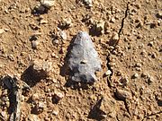 Hohokam corner-notched arrowhead in situ in the Tucson Basin
 -
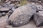 Petroglyphs at the Painted Rock Petroglyph Site.
 -
 Pictographs at Huerfano Butte.
 -
 Bedrock mortars at Huerfano Butte
 -
 Hohokam Glycymeris shell art.
 -
 A large plaza in front of the Mesa Grande Temple Mound which was enclosed by a large adobe wall.


See also
- Agriculture in the prehistoric Southwest
- Ancestral Puebloans
- Oasisamerica cultures
- List of dwellings of Pueblo peoples
References
- ^ ISBN 978-0-500-28532-9.
- ^ "Hohokam or Huhugam?". Archaeology Southwest. 2019. Retrieved May 1, 2019.
- ^ ISBN 978-0-500-28532-9.
- ISBN 978-0-500-28532-9.
- ISBN 978-0-520-25477-0.
- ^ "Definition of HOHOKAM".
- ^ "O'odham explanation of the term Huhugam". Archaeology Southwest. 2019. Retrieved May 1, 2019.
- ^ Pietrorazio, Gabriel (October 10, 2022). "Record Heat Waves And Droughts Can't Dry Up This Native Garden In Phoenix". Next City. Retrieved October 10, 2022.
- ^ -wni hohokam
- ^ a b "The Hohokam". Arizona Museum of Natural History. 2019. Archived from the original on November 13, 2015. Retrieved May 1, 2019.
- ISBN 978-0-500-28532-9.
- ^ a b "The Hohokam". Arizona Museum of Natural History, City of Mesa. Archived from the original on November 30, 2012. Retrieved November 30, 2012.
- ^ 2007-036 General COP Treatment Plan; Pueblo Grande Museum Project 2007–95; City of Phoenix Project No. ST87350010; p. 9 Cultural Context Archived March 24, 2014, at the Wayback Machine
- ^ Haury, Emil W Snaketown: 1964–1965, Kiva Vol. 31, No. 1. Maney Publishing on behalf of the Arizona Archaeological and Historical Society, Oct. 1965, p. 8.
- ^ Powell 2008, pp. 32, 33.
- ISBN 978-0-500-28532-9.
- ^ "Hohokam Traditions and Lifestyles". Archaeology Southwest. 2019. Retrieved May 1, 2019.
- ^ Dart, Allen (June 2014). "Drawing the Line on Hohokam: The Continental Site Revisited" (PDF). Bulletin of Old Pueblo Archaeological Center. 68: 1–25 – via Old Pueblo Archaeology.
- ^ "Lake Pleasant (Images of America)", Author: Gerard Giordano; Page: 13; Arcadia Publishing; 978-0-7385-7176-8
- ^ Fish, Suzanne K. "Hohokam Impacts on Sonoran Desert Environment" in Imperfect Balance: Landscape Transformations in the Precolumbian Americas. ed by David L. Lentz. New York: Columbia U Press, 2000, pp.251–280
- ISBN 0870447998.)
{{cite book}}: CS1 maint: multiple names: authors list (link - S2CID 162245875– via Gale General OneFile.
- S2CID 163554279– via Gale General OneFile.
- S2CID 109408200. Retrieved November 15, 2019.
- ^ Banning, E.B. (2000). The Archaeologist's Laboratory. Hingham, U.S.: Kluwer Academic Publishers. p. 169.
- ^ (Plog, p. 72)
- ^ "Virtual Hohokam Chronology Building and Research: Los Hornos". mc.maricopa.edu. Retrieved July 30, 2008.
- ^ Hohokam Pima National Monument
- ^ Arizona Museum of Natural History: Mesa Grande Ruins — the ruins are under direction of the museum.
- ^ Mesa Parks Dept: Park of the Canals Archived May 27, 2010, at the Wayback Machine
- ^ Phoenix Parks Dept: Pueblo Grande Museum Archeological Park Archived April 13, 2010, at the Wayback Machine — Pueblo Grande Ruin and Irrigation Sites.
Further reading
- Gladwin, Harold S., 1965 Excavations at Snaketown, Material Culture.
- Haury, Emil, 1978 The Hohokam: Desert Farmers and Craftsmen.
- Chenault, Mark, Rick Ahlstrom, and Tom Motsinger, 1993 In the Shadow of South Mountain: The Pre-Classic Hohokam of La Ciudad de los Hornos", Part I and II.
- Craig, Douglas B., 2001 The Grewe Archaeological Research Project, Volume 1: Project Background and Feature Descriptions.
- Crown, Patrica L. and Judge, James W, editors. Chaco & Hohokam: Prehistoric Regional Systems in the American Southwest. School of American Research Press, Santa Fe, New Mexico, 1991. ISBN 0-933452-76-4.
- Russell, Frank, 2006 (reprint), The Pima Indians.
- Clemensen, A., 1992 Casa Grande Ruins National Monument, Arizona: A Centennial History of the First Prehistoric Reserve.
- Plog, Stephen. Ancient Peoples of the American Southwest. Thames and Hudson, London, England, 1997. ISBN 0-500-27939-X.
- Seymour, Deni J., 2007a "A Syndetic Approach to Identification of the Historic Mission Site of San Cayetano Del Tumacácori", International Journal of Historical Archaeology, Vol. 11(3):269–296. https://doi.org/10.1007%2Fs10761-007-0031-9
- Seymour, Deni J., 2007b "Delicate Diplomacy on a Restless Frontier: Seventeenth-Century Sobaipuri Social And Economic Relations in Northwestern New Spain, Part I". New Mexico Historical Review, Volume 82, No. 4.
- Seymour, Deni J., 2008a "Delicate Diplomacy on a Restless Frontier: Seventeenth-Century Sobaipuri Social And Economic Relations in Northwestern New Spain, Part II", New Mexico Historical Review, Volume 83, No. 2.
- Wilcox, David R., C. Sternberg, and T. R. McGuire. Snaketown Revisited. Arizona State Museum Archaeological Series 155, 1981, University of Arizona.
- Wilcox, David R., and C. Sternberg. Hohokam Ballcourts and Their Interpretation. Arizona State Museum Archaeological Series 160, 1983, University of Arizona.
- Wood, J. Scott 1987 "Checklist of Pottery Types for the Tonto National Forest", The Arizona Archaeologist 21, Arizona Archaeological Society.
- Lekson, Stephen H., 2008 A History of the Ancient Southwest. School for Advanced Research Press, Santa Fe.
External links
- University of Arizona: "Hohokam Indians of the Tucson Basin" – an online book.
- Encyclopædia Britannica: "Hohokam Culture"
- National Park Service: Casa Grande Ruins National Monument homepage
- National Park Service: Hohokam Pima National Monument
- Tucsoncitizen.com: "Hohokam stargazer may have recorded 1006 supernova"
- Skytonight.com: "Experts question Hohokam "supernova" interpretation"
- Archaeology Southwest: Pieces of the Puzzle – "What happened to the Hohokam?"
- Historic American Engineering Record (HAER) No. AZ-89, "Hohokam Irrigation Canals, Pueblo Grande Museum, Phoenix, Maricopa County, AZ", 3 data pages
| Contemporary peoples native to Arizona |
|
|---|---|
| Prehistoric cultures in Arizona | |
See also: List of Indian reservations in Arizona | |