
Hopi Reservation
Hopi Reservation
Hopitutskwa (Hopi) | |
|---|---|
|
Flag  Seal | |
 Location in Arizona | |
| Tribe | Hopi |
| Country | United States |
| State | Arizona |
| Counties | Coconino Navajo |
| Established | December 16, 1882 |
| Constitution | December 19, 1936 |
| Capital | Kykotsmovi (de facto)[citation needed] |
| Subdivisions | |
| Government | |
| • Body | Hopi Tribal Council |
| • Chairman | Timothy Nuvangyaoma |
| • Vice Chairman | Alfred Lomahquahu Jr. |
| Area | |
| • Total | 6,557.262 km2 (2,531.773 sq mi) |
| Population (2017)[1] | |
| • Total | 9,268 |
| • Density | 1.4/km2 (3.7/sq mi) |
| Time zone | Mountain: UTC −7 (no DST) |
| Website | hopi-nsn.gov |
| People | Hopi |
|---|---|
| Language | Hopilàvayi, Hand Talk |
| Country | Hopitutskwa |
Oraibi
The Hopi Reservation (
2000 census
had a population of 6,946.
The two nations formerly shared the
The system of villages unites three
Walpi is the oldest village on First Mesa, having been established in 1690 after the villages at the foot of mesa Koechaptevela were abandoned for fear of Spanish reprisal after the 1680 Pueblo Revolt. [citation needed] The Tewa people live on First Mesa. Hopi also occupy the Second Mesa and Third Mesa. The community of Winslow West is off-reservation trust land of the Hopi tribe.[citation needed
]
The Hopi Tribal Council is the local governing body consisting of elected officials from the various reservation villages. Its powers were given to it under the Hopi Tribal Constitution.[citation needed]
The Hopi consider their life on the reservation (in particular the traditional
Hopi High School is the secondary education institute for reservation residents. [citation needed
]
Hopi Radio, a station with a mix of traditional Hopi and typical American programming is run for the reservation and provides internships for Hopi High School.[citation needed]
Communities

- Keams Canyon
- Lower and Upper Moenkopi
- Polacca
- Winslow West
- Yuuwelo Paaki (Spider Mound)
- Kykotsmovi)
First Mesa
- Waalpi (Walpi)
- Hanoki(Hano or Tewa)
- Sitsomovi (Sichomovi)
Second Mesa
- Songoopavi (Shongopavi)
- Musangnuvi (Mishongnovi)
- Shipaulovi)
Third Mesa
- Hoatvela (Hotevilla)
- Paaqavi (Bacavi)
- Munqapi (Moencopi)
- Orayvi (Oraibi)
Time zone

The Hopi Reservation lies within the Mountain Time Zone, like most of Arizona, but unlike the surrounding Navajo Nation, it does not observe daylight saving time.
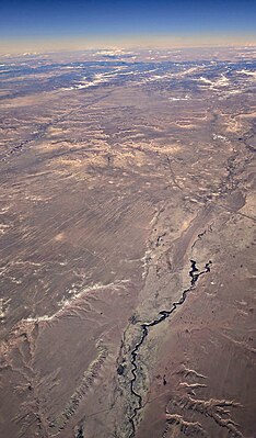
Aerial views
Aerial views looking north along the central three of the reservation's five major washes,[4] from west to east:
-
 Dinnebito Wash, with Third Mesa in the distance
 -
 Oraibi Wash and Indian Route 2
 -
 Polacca Wash, crossed byArizona Route 87, with First Mesa and Second Mesa visible in the distance


See also
- Hopi flag
References
- ^ 2013-2017 American Community Survey 5-Year Estimates. "My Tribal Area". United States Census Bureau.
{{cite web}}: CS1 maint: numeric names: authors list (link) - ^ "Short History of Big Mountain–Black Mesa". Archived from the original on 11 August 2014. Retrieved 5 Aug 2013.
- ^ "Navajo–Hopi Long Land Dispute". Retrieved 5 Aug 2013.
- ^ Lionel Puhuyesva, James A. Duffield, and Max Taylor. "Wetland Program Development via the Clean Water Act, Hopi Reservation, Arizona" (PDF). Coconino Plateau Water Advisory Council. Retrieved 27 June 2019.
{{cite web}}: CS1 maint: multiple names: authors list (link)
External links
See also: Indigenous peoples of Arizona |
 | ||||
Towns | ||||
| CDPs |
| |||
| Populated places | ||||
| Indian reservations | ||||
Ghost towns | ||||
| Footnotes | ‡This populated place also has portions in an adjacent county or counties | |||
| ||||
 | ||||
Towns | ||||
| CDPs |
| |||
| Populated places | ||||
| Indian reservations | ||||
| Ghost towns | ||||
| Footnotes | ‡This populated place also has portions in an adjacent county or counties | |||
| ||||
35°54′42″N 110°36′56″W / 35.91167°N 110.61556°W
| International | |
|---|---|
| National | |
| Other | |