
Houaphanh province
This article is written like a encyclopedic style or move the content to Wikivoyage . (April 2021) |
Houaphanh province
ແຂວງ ຫົວພັນ | |
|---|---|
UTC+7 (ICT) | |
| ISO 3166 code | LA-HO |
| HDI (2017) | medium · 8th |
Houaphanh province (
Houaphanh province covers an area of 16,500 square kilometres (6,400 sq mi). The province is bordered by
The province is the home to the
Houaphanh is one of the poorest areas of Laos, but has dramatic scenery and fine textile traditions.
History
The province, along with Xiangkhoang, was part of the
The Lê Duy Mật rebels ruled the area from 1739 to 1770. In 1802, Emperor Gia Long of the newly founded Nguyễn dynasty ceded the region to the Kingdom of Vientiane. However, in the aftermath of the Lao rebellion, Chao Nôy, the prince ruler of Muang Phuan, who earlier sided with the Siamese, was executed by the Vietnamese. Emperor Minh Mạng of Vietnam reannexed the territory in 1828.
It remained a Vietnamese outpost territory until 1893 when ownership was switched by French authorities back to Laos during the French colonial period. Under the French spelling, the province was usually Hua Phan.[2][4]
The province is home to the Viengxay caves, an extensive network of caves used by the
Houaphanh province was noted for its samana ('re-education') camps. The Lao royal family were believed to have been taken to one such camp near
Religious minorities often face persecution in the province, and at the end of 1999 numerous minorities were arrested.[7]
Geography
Houaphanh province[8] covers an area of 16,500 square kilometres (6,400 sq mi).[5] The province is bordered by Vietnam to the north, east and southeast, Xiangkhouang province to the south and southwest, and Luang Prabang province to the west.[9]
The terrain is rugged, with dense mountainous forest forming much of the province, particularly on the western side.[10] Notable settlements include Xam Neua, Muong U, Houamuang, Chomsan, Muang Pan, Muang Hom, Muang Peu, Muang Xon, Ban Muang-Et, Ban Nampang, Muong Vene, Xamtai, Muang Na, and Poungthak.[11]
The main road running through the province is Route 6. The principal rivers are the
Protected areas

Areas of Houaphanh province are in the
The Nam Neun IBA area of Nam Et is adjacent to the NBCA. Nam Neun is 85,450
The Phou Louey Massif IBA is in the Nam Et-Phou Louey NBCA and adjacent to the Nam Neun IBA. The Phou Louey IBA stretches beyond Houaphanh province into Luang Prabang province. It is 60,070 ha in size and is at an elevation of 700–1,800 metres (2,300–5,900 ft). The habitat is characterized as mixed deciduous forest, semi-evergreen forest, lower montane evergreen forest, upper montane evergreen forest, and secondary grassland. Key avifauna include beautiful nuthatch (Sitta formosa), rufous-necked hornbill (Aceros nipalensis), Blyth's kingfisher (Alcedo hercules), and yellow-vented warbler (Phylloscopus cantator). There are four confirmed species of turtles and two confirmed species of ungulate.[14]
The 69,000 hectare Nam Xam IBA is in the 70,000 ha Nam Xam National Biodiversity Conservation Area (NBCA). The IBA's elevation varies between 300–1,800 metres (980–5,910 ft). The topography is characterized by hills and low mountains. The habitat includes dry evergreen forest, Fokienia forest, mixed deciduous forest, as well as stunted, mossy upper montane forest. Notable avifauna includes beautiful nuthatch (Sitta formosa), brown hornbill (Anorrhinus tickelli), great hornbill (Buceros bicornis), red-collared woodpecker (Picus rabieri), and rufous-necked hornbill (Aceros nipalensis).[15]
Administrative divisions
The province is made up of the following districts:[5]
| Map | Code | Name | Lao script |
|---|---|---|---|

| |||
| 7-01 | Xam Neua District | ເມືອງຊຳເໜືອ | |
| 7-02 | Xiengkho District
|
ເມືອງຊຽງຄໍ້ | |
| 7-03 | Viengthong District
|
ເມືອງວຽງທອງ | |
| 7-04 | Viengxay District
|
ເມືອງວຽງໄຊ | |
| 7-05 | Houameuang District
|
ເມືອງຫົວເມືອງ | |
| 7-06 | Samtay District
|
ເມືອງຊຳໃຕ້ | |
| 7-07 | Sop Bao District
|
ເມືອງສົບເບົາ | |
| 7-08 | Et District
|
ເມືອງແອດ |
Economy
Houaphanh province is one of the poorest areas of Laos. In 1998, three quarters of the population were classified as poor. In 2002 GDP per capita was US$50–204, compared to the national average of US$350.[16] Socio-economic problems plague the province, with an infant mortality rate and access to safe water and medical facilities far worse than the national average.[16]
Bamboo is important in rural parts of the province and used as a principal building material. Women play a key role in the collecting of bamboo shoots.
Xam Neua, the provincial centre, is the most important market centre for regional trade. Many villagers come here to sell their goods, especially handicrafts and textiles that the people of the province are famed for. Saleu and Nasala villages in Xiengkho District along Route 6 are noted for their skills at weaving and handicrafts.[5] Samtay is noted for its textiles.[6]
A tourism development plan has been created for the province, capitalizing on the caves as tourist attractions, providing information and services at the sites.[19]
Asian Development Bank launched a project in 2006 specifically covering 31 villages of Xam Neua and Samtay Districts to wean people away from shifting cultivation practices and to eliminate opium addiction; as of 2006, opium was grown in the province in an area of about 30 ha. The project includes programs to increase income, conserve forest resources, eradicate opium, and experiment with pilot projects to enhance livelihood sources.[20]
Demography
The population of the province, as of 2015, was 289,393.]
Landmarks
Historical attractions here are
- Kaysone Phomvihane's House where (in President Kaysone's garden) people narrate the history of how Viengxay became the center for liberation and suffered air attacks in the beginning
- Kaysone Phomvihane's Cave Office — the largest cave where gifts, a statue of Lenin, and collection of books can be seen
- Politburo Meeting Room: in the cave the leaders of the freedom movement deliberated on policies and important decisions
- Nouhak Phoumsavan's House (Pathet Lao's founding father)
- Nouhak Phoumsavan's Cave, Prince Souphanouvong's (who was known as "Red Prince") house and garden
- a stupa erected during the war to bury Souphanouvong's son, Ariya Thammasin to avoid detection during the war
- Prince Souphanouvong's Cave was used as a protection bunker during bombing by US forces known as "Ravens"
- Cave of Phoumi Vongvichid who established a schooling curriculum in the cave
- Cave of Sithone Kommadane, a valiant fighter during early years of war
- House of General Khamtay Siphandone, supreme military commander who motivated people to take to arms and Khamtay Siphandone's Cave where he established and operated the communication system with his forces
- Cave Barracks of ex soldiers
- Artillery Cave where heavy anti-aircraft batteries were operated
- Xanglot Cave where weddings and traditional festivals were held during the war[23]
Wat Pho Xai or Wat Pho Xaysanalam is on the outskirts of Sam Neua.
Nameuang Hot Springs is another landmark amidst the valley of paddy fields on the way to Xam Neua, where there is the Houaiyad waterfall. The springs are the source of a small river. In Houaiyad village, crashed aircraft parts and cans of war relics are recycled into belts.[23]
Villages
Gallery
-
 Pathet Lao, Xam Neua, 1953.
 -
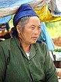 Market vendor, Xam Neua
 -
 Wat Pho Xai, Xam Neua


Citations
- ^ "Sub-national HDI - Area Database - Global Data Lab". hdi.globaldatalab.org. Retrieved 2018-09-13.
- ^ a b Auzias & Labourdette 2012, p. 265.
- ^ The Thai peoples, Volume 1, Page 91, Erik Seidenfaden, 1967 "They are Buddhists but also animists and much given to feast the spirits of their ancestors. Southeast of Muang Thaeng, and east of the Annamite cordillera, lies the plateau of and east of the Annamite cordillera, lies the plateau of Hua Phan, formerly known as Hua Phan Tang Ha Tang Hok, i.e., the five and the sixth province, some translate this as the five and the sixth county of one thousand inhabitants each."
- ^ a b Mission Pavie, Indo-Chine, 1879-1895: Etudes diverses, Volume 3, Page 142, 1900 "Ces territoires, dont le nom serait: Hua Panh, Tang-Ha, Tang-Hoc. comprendraient, en plus des six grands cantons énumérés ailleurs"
- ^ a b c d e "ABOUT HOUAPHANH". Department of Tourism Marketing of Ministry of Information, Culture and Tourism (MICT). Archived from the original on 2019-11-05. Retrieved 2019-11-18.
- ^ a b c d Burke & Vaisutis 2007, p. 185.
- ^ Larkin 2001, p. 202.
- ^ "Home". Regions. Official website of Laos Tourism. Archived from the original on 11 January 2013. Retrieved 7 January 2013.
- ^ Maps (Map). Google Maps.[not specific enough to verify]
- ^ APANews. Asia-Pacific Agroforestry Network. 1992. pp. 112–3. Retrieved 6 December 2012.
- ^ "Base Map:Lao People's Democratic Republic (LPDR)". UNOSAT. Retrieved 4 December 2012.[not specific enough to verify]
- ^ "Laos". Ecoi.net. Retrieved 6 December 2012.[not specific enough to verify]
- ^ "Datazone: Nam Et". Birdlife International. Retrieved 8 November 2017.
- ^ "Datazone: Phou Louey". Birdlife International. Retrieved 8 November 2017.
- ^ "Datazone: Nam Xam". Birdlife International. Retrieved 8 November 2017.
- ^ a b c d e f g "Houaphanh Bamboo Value Chain Analysis". Netherlands Development Organization. Retrieved 6 December 2012.
- ^ United States Congress. House Committee on Appropriations. Subcommittee on Foreign Operations, Export Financing, and Related Programs (2002). Foreign Operations, Export Financing, and Related Programs Appropriations for 2003: Hearings Before a Subcommittee of the Committee on Appropriations, House of Representatives, One Hundred Seventh Congress, Second Session. U.S. Government Printing Office. p. 860. Retrieved 6 December 2012.
{{cite book}}: CS1 maint: multiple names: authors list (link) - ^ United States Congress. House Committee on Foreign Affairs (1991). Narcotics control efforts in Southeast Asia: business as usual: report of a staff study mission to CINCPAC, the Philippines, Singapore, Thailand, Laos, Hong Kong, and the People's Republic of China, November 2–26, 1990 to the Committee on Foreign Affairs, U.S. House of Representatives. US GPO. p. 20. Retrieved 6 December 2012.
- ^ Hitchcock 2009, p. 175.
- ^ "Description: Alternative Livelihood for Upland Ethnic Groups in Houaphanh Province (financed by the Japan Fund for Poverty Reduction)". Asian Development Bank. Retrieved 12 December 2012.
- ^ "Results of Population and Housing Census 2015" (PDF). Lao Statistics Bureau. Retrieved 1 May 2020.
- ^ "Provinces of Laos". Statoids.com. Retrieved 1 November 2012.
- ^ a b c "Houaphanh Province: Birthplace of Lao PDR" (PDF). STDP Laos. Archived from the original (PDF) on 4 March 2016. Retrieved 12 December 2012.
- ^ a b Burke & Vaisutis 2007, p. 186.
General and cited references
- Auzias, Dominique; Labourdette, Jean-Paul (28 March 2012). Laos 2012–2013 (in French). Petit Futé. ISBN 978-2-7469-5375-8.
- Burke, Andrew; Vaisutis, Justine (1 August 2007). Laos 6th Edition. Lonely Planet. ISBN 978-1-74104-568-0.
- Hitchcock, Michael (2009). Tourism in Southeast Asia: Challenges and New Directions. NIAS Press. ISBN 978-87-7694-034-8.
- Larkin, Barbara (1 July 2001). International Religious Freedom (2000): Report to Congress by the Department of State. DIANE Publishing. ISBN 978-0-7567-1229-7.
Further reading
- ISBN 9781569474648. Retrieved 14 April 2021. A Dr. Siri Paiboun mystery set in Houaphanh province.
Places adjacent to Houaphanh province | ||||||||||||||||
|---|---|---|---|---|---|---|---|---|---|---|---|---|---|---|---|---|
| ||||||||||||||||