
Huangshan
| Huangshan 黄山 | |
|---|---|
Ultra | |
| Coordinates | 30°07′30″N 118°10′00″E / 30.12500°N 118.16667°E[1] |
| Geography | |
 Huangshan 黄山 Location in eastern China  Huangshan 黄山 Huangshan 黄山 (China) | |
| Location | Huangshan City, Anhui |
| Official name | Mount Huangshan |
| Criteria | Cultural and Natural: (ii), (vii), (x) |
| Reference | 547bis |
| Inscription | 1990 (14th Session) |
| Extensions | 2012 |
| Area | 16,060 ha (62.0 sq mi) |
| Buffer zone | 49,000 ha (190 sq mi) |
| Huangshan | |
|---|---|
lit. ) |
Huangshan (
The area is well known for its scenery, sunsets, peculiarly-shaped
Physical description
.jpeg)


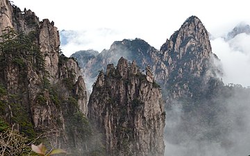
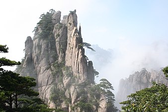
The Huangshan mountain range has many peaks, some more than 1,000 meters (3,250 feet) high.
The vegetation of the area varies with elevation.
The mountaintops often offer views of the clouds from above, known as the Sea of Clouds (Chinese: 云海; pinyin: yúnhǎi)[9] or "Huangshan Sea"[8] because of the cloud's resemblance to an ocean, and many vistas are known by names such as "North Sea" or "South Sea."[8] One writer remarked on the view of the clouds from Huangshan as follows:
To enjoy the magnificence of a mountain, you have to look upwards in most cases. To enjoy Mount Huangshan, however, you've got to look downward.[8]
The area also is host to notable light effects, such as the renowned sunrises. Watching the sunrise is considered a "mandatory" part of visiting the area.[13] A phenomenon known as Buddha's Light (Chinese: 佛光; pinyin: fóguāng)[14] is also well-known and, on average, Buddha's Light only appears a couple of times per month.[15] In addition, Huangshan has multiple hot springs, most of them located at the foot of the Purple Cloud Peak. The water stays at 42 °C (107.6 °F) all year,[16] and has a high concentration of carbonates. The waters are said to help prevent skin, joint, and nerve illness.[7]
History


Huangshan was formed approximately 100 million years ago and gained its unique
During the Qin dynasty, Huangshan was known as Yishan (Mount Yi). In 747 AD, its name was changed to Huangshan (Mount Huang) by imperial decree;[17] the name is commonly thought to have been coined in honor of Huang Di (the Yellow Emperor), a legendary Chinese emperor and the mythological ancestor of the Han Chinese.[18] One legend states that Huangshan was the location from which the Yellow Emperor ascended to Heaven.[5] Another legend states that the Yellow Emperor "cultivated moral character and refined Pills of Immortality in the mountains, and in so doing gave the mountains his name.[7] The first use of this name "Huangshan" often is attributed to Chinese poet Li Bai.[18] Huangshan was fairly inaccessible and little-known in ancient times, but its change of name in 747 AD seems to have brought the area more attention; from then on, the area was visited frequently and many temples were built there.[17]
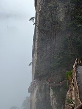
Huangshan is known for its stone steps,[5] carved into the side of the mountain, of which there may be more than 60,000 throughout the area.[13][19][20] The date at which work on the steps began is unknown, but they have been said to be more than 1,500 years old.[19]
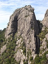
Over the years, many scenic spots and physical features on the mountain have been named;[8] many of the names have narratives behind them. For example, one legend tells of a man who did not believe the tales of Huangshan's beauty and went to the mountains to see them; almost immediately, he was converted to the same view. One of the peaks he is said to have visited was named Shixin (始信), roughly meaning "start to believe."[8]
In 1982, Huangshan was declared a "site of scenic beauty and historic interest" by the
In 2002, Huangshan was named the "sister mountain" of Jungfrau in the Swiss Alps.[5]
Artistic and scientific inspirations
Much of Huangshan's reputation derives from its significance in Chinese arts and literature.
The area also has been a location for scientific research because of its diversity of flora and wildlife. In the early part of the twentieth century, the geology and vegetation of Huangshan were the subjects of multiple studies by both Chinese and foreign scientists.[17] The mountain is still a subject of research. For example, in the late twentieth century a team of researchers used the area for a field study of Tibetan macaques, a local species of monkey.[23]
Tourism

Having at least 140 sections open to visitors,
There are more than 50 kilometers of footpaths providing access to scenic areas for visitors and staffers of the facilities.
The hotels, restaurants, and other facilities at the top of the mountain are serviced and kept stocked by porters who carry resources around the mountain on foot, hanging their cargo from long poles balanced over their shoulders or backs.[28]
Climate
Huangshan has a
| Climate data for Huangshan (elevation 1,840 m (6,040 ft), 1991–2020 normals) | |||||||||||||
|---|---|---|---|---|---|---|---|---|---|---|---|---|---|
| Month | Jan | Feb | Mar | Apr | May | Jun | Jul | Aug | Sep | Oct | Nov | Dec | Year |
| Record high °C (°F) | 12.9 (55.2) |
13.8 (56.8) |
16.3 (61.3) |
22.3 (72.1) |
24.5 (76.1) |
25.7 (78.3) |
27.6 (81.7) |
27.1 (80.8) |
26.0 (78.8) |
23.7 (74.7) |
17.7 (63.9) |
14.2 (57.6) |
27.6 (81.7) |
| Mean daily maximum °C (°F) | 1.5 (34.7) |
3.5 (38.3) |
7.2 (45.0) |
12.3 (54.1) |
16.2 (61.2) |
18.3 (64.9) |
20.8 (69.4) |
20.6 (69.1) |
17.4 (63.3) |
13.2 (55.8) |
8.9 (48.0) |
3.4 (38.1) |
11.9 (53.5) |
| Daily mean °C (°F) | −1.8 (28.8) |
0.1 (32.2) |
3.5 (38.3) |
8.6 (47.5) |
12.8 (55.0) |
15.6 (60.1) |
18.0 (64.4) |
17.7 (63.9) |
14.3 (57.7) |
9.9 (49.8) |
5.6 (42.1) |
0.1 (32.2) |
8.7 (47.7) |
| Mean daily minimum °C (°F) | −4.9 (23.2) |
−3.1 (26.4) |
0.1 (32.2) |
5.4 (41.7) |
9.9 (49.8) |
13.4 (56.1) |
16.1 (61.0) |
15.7 (60.3) |
11.9 (53.4) |
7.1 (44.8) |
2.6 (36.7) |
−3.1 (26.4) |
5.9 (42.7) |
| Record low °C (°F) | −22.0 (−7.6) |
−19.1 (−2.4) |
−15.9 (3.4) |
−11.7 (10.9) |
−4.7 (23.5) |
1.3 (34.3) |
8.5 (47.3) |
6.8 (44.2) |
−0.6 (30.9) |
−9.8 (14.4) |
−19.0 (−2.2) |
−22.7 (−8.9) |
−22.7 (−8.9) |
| Average precipitation mm (inches) | 99.5 (3.92) |
115.3 (4.54) |
175.8 (6.92) |
222.0 (8.74) |
286.2 (11.27) |
481.4 (18.95) |
370.7 (14.59) |
301.2 (11.86) |
147.4 (5.80) |
90.1 (3.55) |
91.4 (3.60) |
68 (2.7) |
2,449 (96.44) |
| Average precipitation days (≥ 0.1 mm) | 14.5 | 13.9 | 17.0 | 16.2 | 17.1 | 18.8 | 16.8 | 19.2 | 14.0 | 10.9 | 11.1 | 10.8 | 180.3 |
| Average snowy days | 9.8 | 6.8 | 5.4 | 0.9 | 0 | 0 | 0 | 0 | 0 | 0.1 | 2.0 | 6.5 | 31.5 |
| Average relative humidity (%)
|
67 | 73 | 76 | 77 | 79 | 88 | 92 | 92 | 87 | 71 | 64 | 59 | 77 |
| Mean monthly sunshine hours | 142.4 | 129.7 | 136.5 | 144.6 | 152.2 | 99.6 | 123.3 | 112.0 | 124.7 | 168.9 | 159.6 | 164.3 | 1,657.8 |
| Percent possible sunshine | 44 | 41 | 37 | 37 | 36 | 24 | 29 | 28 | 34 | 48 | 51 | 52 | 38 |
| Source: China Meteorological Administration[29][30] | |||||||||||||
Panoramas
.jpg)


Image gallery
-
 View from a cable car
 -
 Bijia Peak
 -

-
 Artificial steps on the cliffs of Huangshan
 -
 Xihai Great Canyon
 -
 Shixin Peak
 -
 A rock formation in Huangshan
 -
 Carved steps to Tiandu Peak
 -
 A rock formation in Huangshan
 -
 Huangshan pines
 -
 Huangshan with trees and clouds
 -
 Summit of mountain in Huangshan
_Mount._Huangshan_-_panoramio.jpg)


.jpg)


See also
References
- ^ a b c "Lianhua Feng - Lotus Peak, HP Huang Shan" on Peaklist.org - Central and Eastern China, Taiwan and Korea. This data is specific to the high point of the range only. Retrieved 2011-10-5.
- ^ a b c d e f g Bernstein, pp. 125–127.
- ^ "Origins and new interpretations on the theory of Pleistocene glaciation in South-East China - the case of the Lushan and Huangshan ranges". Annales de Géographie. 101: 472.
- ^ "Huangshan Mountain". [Huangshan Tour]. Archived from the original on 3 March 2009. Retrieved 2008-08-05.
- ^ a b c d e f Cao, pp. 114–127.
- ^ a b "Mount Huangshan - UNESCO World Heritage Center". UNESCO. 2008. Retrieved 2008-08-05.
- ^ a b c d e f Huangshan Mountains, p. 12.
- ^ a b c d e f g Guo, pp. 62–64.
- ^ a b Heiss, p. 124
- ^ Heiss, p. 113
- ^ Heiss, p. 52
- ^ "Yellow Mountain Maofeng Tea". [Cultural China]. Archived from the original on 2009-03-02. Retrieved 2008-10-08.
- ^ New York Times. Retrieved 2008-10-08.
- China.org.cn. Retrieved 23 December 2008.
- ^ Raitisoja, Geni (4 October 2006). "Huangshan: "No. 1 Mountain Under Heaven"". gbtimes.com. Archived from the original on 30 December 2014. Retrieved 30 December 2014.
- ^ "Welcome to Huang Shan, Mount Huang". [Famous Taoism and Buddhism Sanctuaries in China]. Wudang Taoist Internal Alchemy. Archived from the original on 2008-10-21. Retrieved 2008-09-08.
{{cite web}}: External link in|publisher= - ^ a b c d e f g "Mount Huangshan Scenic Beauty and Historic Interest Site". [Protected Areas and World Heritage]. United Nations Environment Programme. October 1990. Archived from the original on 2008-05-10. Retrieved 2008-10-08.
- ^ a b "Huang Shan". [ChinaTravel.net]. Archived from the original on 2008-10-07. Retrieved 2008-10-08.
- ^ a b "The Mystic World of Shanshui: Huangshan". UNESCO Culture Center. UNESCO. Archived from the original (.wmv) on 2008-08-16. Retrieved 2008-10-08.
{{cite web}}: External link in|work= - University of Hawaii. Archived from the original(PDF) on 18 September 2009. Retrieved 6 December 2008. p. 52.
- ^ China.org.cn. 1990. Retrieved 2008-10-08.
- ^ McGraw, p. 109
- ^ Ogawa, p.9.
- ^ "Mt.Huangshan Travel Guide" ChinaTour.Net Accessed 2015-1-21
- Xinhua. 3 August 2008. Archived from the originalon 6 November 2012. Retrieved 6 September 2010.
- ^ "Hefei, Anhui Province". Archived from the original on 20 December 2008. Retrieved 23 December 2008.
- ^ "AAAAA Scenic Areas". China National Tourism Administration. 16 November 2008. Archived from the original on 4 April 2014. Retrieved 9 April 2011.
- ^ Heiss, p. 132
- ^ 中国气象数据网 – WeatherBk Data (in Simplified Chinese). China Meteorological Administration. Retrieved 24 September 2023.
- ^ "Experience Template" 中国气象数据网 (in Simplified Chinese). China Meteorological Administration. Retrieved 24 September 2023.
Bibliography

- Bernstein, Ken (1999). China pocket guide. Revised by JD Brown; edited by Richard Wallis. Berlitz Publishing Company. ISBN 2-8315-7049-2.
- Cao Nanyan (2003). China: World Heritage Sites. Beijing: China Architecture and Building Press. ISBN 0-7607-8685-2.
- Guo Changjian; Song Jianzhi (2003). World Heritage Sites in China. 五洲传播出版社 (Wuzhou Publishing House). ISBN 7-5085-0226-4.
- Heiss, Mary Lou; Robert J. Heiss (2007). The Story of Tea. Ten Speed Press. p. 122. ISBN 978-1-58008-745-2.
Huangshan.
- Huangshan Mountains. China Travel and Tourism Press. 1998. ISBN 7-5032-1520-8.
- Ogawa, Hideshi; Akie Yanagi (2006). Wily Monkeys: Social Intelligence of Tibetan Macaques. Trans Pacific Press. ISBN 1-920901-97-3.
External links
- Huangshan overview by the Huangshan Management Committee
- Huangshan Mountain Travel Guide by Huangshan China International Travel Service
- Huizhou Geography Essay by Huizhou Geography
| East |
|  |
|---|---|---|
| South Central |
| |
| Southwestern | ||
| North | ||
| Northeast | ||
| Northwestern | ||
| Multiple regions | ||
| Northwestern | |
|---|---|
Qinghai-Tibet and Southwestern | |
| Northeast | |
| North and East | |
| Central | |
| South | |