Hudson Bay Lowlands
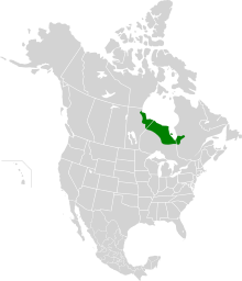
The Hudson Bay Lowlands is a vast
Severn, Fawn, Winisk, Asheweig, Ekwan, Attawapiskat, and Albany in Ontario, and the Harricana, Rupert and Eastmain in Quebec.[1] This is the largest wetland in Canada, and one of the largest in the world.[2] The region can be subdivided into three bands running roughly northwest to southeast: the Coastal Hudson Bay Lowland (a narrow band along the northern coast),[3] Hudson Bay Lowland (a broader band extending to slightly south of the Ekwan River),[4] and James Bay Lowland (all the rest of the southern/eastern lands, making up close to 50% of the total Lowlands area).[5]
The entire area was covered by ice during the last
wolverines.[2]


Early discoveries and exploration
The local
Fort Severn
.
Geography
The region is named after the nearby
conifer forest and peat land, with typical subarctic and arboreal plants.[6]
Industries
The forestry industry is present in the
The Hudson Bay Lowlands also contain vast mineral deposits, particularly chromite and nickel. The Ring of Fire development project plans to build roads to enable resource extraction. Plans for development in the area are under undergoing environmental assessment.[citation needed]
See also
References
- ^ a b Canadian Encyclopedia - Hudson Bay
- ^ a b Abraham, K.F. and C.J. Keddy. The Hudson Bay Lowland. Pages 118–148 in L.H. Fraser and P.A. Keddy (eds.). 2005. The World's Largest Wetlands: Ecology and Conservation. Cambridge University Press, Cambridge, UK. 488 p.
- ^ Coastal Hudson Bay Lowland ecozone profile
- ^ Hudson Bay Lowland ecozone profile
- ^ James Bay Lowland ecozone profile
- ^ a b Riley, John L. 2003. Flora of the Hudson Bay Lowland and its Postglacial Origins. NRC Research Press, Ottawa, Canada. 236 p.
- ^ Sjörs, H. 1959. Bogs and fens in the Hudson Bay Lowlands. Arctic 12:2-19.
- ^ "Tourism". Town of Moosenee.
External links
- Map of the Hudson Plains Ecoregions
- An Introduction to Ecozones
- Map of major rivers draining into southern Hudson Bay
- Hudson Bay Lowlands - Ontario Ministry of Natural Resources
- Proposed protected areas in Manitoba.
- Hudson Bay in The Canadian Encyclopedia
- Hudson Bay Lowlands - Ottertooth
- Arctic Institute paper by Hugo Sjörs, Bogs and Fens in the Hudson Bay Lowlands.
- "Hudson Bay Lowlands show recent effects of global warming". Max Paris Environment Unit, CBC News. 8 October 2013. Retrieved 2013-10-08.
