
Igoumenitsa
Igoumenitsa
Ηγουμενίτσα | |
|---|---|
UTC+3 (EEST) | |
| Postal code | 461 00 |
| Area code(s) | 26650 |
| Vehicle registration | ΗΝ |
| Website | www.igoumenitsa.gr |
Igoumenitsa (Greek: Ηγουμενίτσα, romanized: Igoumenítsa, Italian: Igomenizza) is a coastal city in northwestern Greece. It is the capital of the regional unit of Thesprotia.
Igoumenitsa is the chief port of
Igoumenitsa features many shops, schools, offices and cargo storages, a university department, a library, an archeological museum, several sport stadiums and tennis courses, a courthouse and a medical clinic. The Thesprotia Police Headquarters and the Municipal Sailing Club are located here. The city itself is built on the slopes of a forested mountain and expands perimetrically around the gulf.
The 2021 census recorded 25,698 inhabitants for the wider Municipality, of which 18,562 in the municipal unit of Igoumenitsa, and 10,315 in the town proper.[1] Igoumenitsa is known for being surrounded by several forests and for its blue waters. The nearby Drepanos Beach is one of the longest sand beaches in the region, with a length of over 7 kilometers.
Names
Igoumenitsa is known by various names in different time periods. During the medieval era it was mentioned in a golden bull by Simeon Uroš (1361). At a 15th century Greek portolan chart it was mentioned as Igoumenitza (Greek: Ηγουμενίτζα).[2] Later in Ottoman times, it was known as Grava (Greek: Γράβα).[3] or Reşadiye.[4] In 1938, after it became the capital city of the prefecture of Thesprotia, its name was changed to the current Igoumenitsa. The name is a derivation from the Greek word Igoumeni which means "commander; abbot".[citation needed] The name has been adopted as Gomenizza in Italian and as Gumenicë in Albanian.
History

In ancient times, near Igoumenitsa, was the town of Gitanae (also known as Titana), and was one of the most important towns of the Kingdom of Thesprotis during the 4th century BC, covering 28 hectares. The circumference of its walls was 2,400 metres. The walls had four gates. Internal walls, in the shape of a sickle, divided the city in half. Its most noteworthy tower, located at the top of the hill, was round, and is thought to have been a religious sanctuary. Excavations have revealed a theatre which seats 2,500 and ruins of two temples.[5][6]
Gitanae was a meeting place of the Epirote League (Livy 42.38.1). A spur near

After the liberation of the region from Ottoman rule during the Balkan wars in 1913, the city name was Grava, a name that stayed in use until 1938, when the town became head of the prefecture of Thesprotia and was then renamed to Igoumenitsa. The town was destroyed in 1944 during the Axis occupation of Greece and a new settlement grew up around the new ferry terminal in the 1950s and 1960s.[3]
Igoumenitsa was burnt by the Italian Fascist army in November 1940.[8] After the creation of the pro-Axis Cham Albanian organisation (Këshilla) in mid-1942 violence was accelerated and on February 19, 1942, a group of Cham Albanians militias murdered Giorgos Vasilakos, head of the prefecture of Thesprotia[9] in Igoumenitsa.[10] On 30 September 1943, a representative of the international Red Cross, having visited the city recorded that the Greek population was expelled from Igoumenitsa and its population had to find refuge to the mountains.[11] Following World War II, the Muslim Cham Albanian residents of Igoumenitsa were expelled after parts of them collaborated with the invading German forces.[12] They were relocated further north under instructions by the German Wehrmacht.[13] The Cham-dialect of the Albanian language is still spoken by a minority of inhabitants in the town and the surrounding area.[14][15]
Municipality


The present municipality Igoumenitsa was formed at the 2011 local government reform by the merger of the following 5 former municipalities, that became municipal units (constituent communities in brackets):[16]
- Igoumenitsa (Agia Marina, Agios Vlasios, Graikochori, Igoumenitsa, Kastri, Kryovrysi, Ladochori, Mavroudi, Nea Selefkeia)
- Margariti (Eleftheri, Karteri, Katavothra, Margariti, Mazarakia, Mesovouni, Spatharaioi)
- Parapotamos (Drimitsa, Geroplatanos, Koritiani, Parapotamos)
- Perdika
- Syvota (Argyrotopos, Faskomilia, Plataria, Syvota)
The municipality has an area of 428.353 km2, the municipal unit 111.752 km2.[17]
Transport

The
The Egnatia Odos motorway, which was opened in 2009 and is part of the ![]() , has significantly enhanced the connection with Thessaloniki and Turkey and shortened the required travelling time from and to the Turkish border by several hours. Between Thessaloniki and the Turkish border, the road runs more or less parallel to the ancient Roman Via Egnatia.[18]
, has significantly enhanced the connection with Thessaloniki and Turkey and shortened the required travelling time from and to the Turkish border by several hours. Between Thessaloniki and the Turkish border, the road runs more or less parallel to the ancient Roman Via Egnatia.[18]
Ports

Igoumenitsa features two ports. The Old Port and the New Port, which is the second busiest
The sea-lines going to and coming from Igoumenitsa are:
|
Internal Maritime Traffic
|
External Maritime Traffic |
According to the draft strategy prepared by the relevant Ministry of Shipping (2012-2013) the port of Igoumenitsa becomes a "Connection Portal" not only of Greece with the rest of Europe, but of the whole of Europe with the Balkans, the Black Sea and the Middle East, through the development of combined transport (maritime-roads) directly and long-term (through the Egnatia railway), incorporating the railroad.
In the beginning of 2012, the First Phase of the construction project of the New Port had been completed and progression to the Second Phase has begun in late 2013 and was completed by 2016, when the Third Phase of the construction began. With the completion of the First phase, Igoumenitsa has become a modern, large port in the Mediterranean Sea, able to serve passenger, commercial and tourist traffic. The completion of the Second Phase, enabled the port to serve large cruise ships. Also, the planned creation of a freight centre in a section within the port area is estimated to greatly strengthen the commercial traffic and turn the city of Igoumenitsa into an international logistics centre.
Port traffic statistics as of 2012:
| Port | Passengers | Cars | Trucks |
|---|---|---|---|
| Igoumenitsa | 896,130 | 212,154 | 149,768 |
| Patras | 555,453 | 102,161 | 122,139 |
Igoumenitsa serves the 61.73% of the maritime traffic, the 67.49% of car traffic and the 55.08% of truck traffic annually.
Population
The population of Igoumenitsa town is 10,315 residents and the urban area (municipal unit) is 18,562. The population of Municipality of Igoumenitsa is 25,698 permanent citizens.[1] Igoumenitsa's population grew rapidly in recent years, as result of the increased traffic in the region because of the New Port. The chart below shows the development of the population of Igoumenitsa and the broader urban area according to the data of the Greek Statistical Agency:
 |
Geography and Climate
Igoumenitsa is located in the north-western corner of Greece in the regional unit of Thesprotia, which is part of the prefecture of Epirus. Igoumenitsa, like much of the west coast of Greece, has a hot-summer Mediterranean climate (Köppen: Csa) with mild to cool, rainy winters and hot, relatively dry summers.
Tourism
Igoumenitsa is known for its green forests and blue crystal waters, and attracts many local tourists from the nearby regions, and especially from Italy. The city provides the possibility for walks, jogging on the beach or mountain, hiking, sports, boating or contact with nature. Also provides access to the Blue Flag beaches of Drepanos and Makrygiali with crystal clear waters and a length of 7 km, with both of them being situated on the northwestern edge of the Gulf of Igoumenitsa. The archaeological museum with exhibits from historical times until the Byzantines period. In recent years, the city has become a growing cruise destination, as cruise station for visits to archaeological sites and natural beauties of Thesprotia but also the entire Ionian coast.[20]
Archaeological Museum

The archaeological museum of Igoumenitsa was opened in 2009 and is located on the north side, next to the Fire Department of the city. It consists of five main sections that showcase the history and culture of the region of Thesprotia from ancient times to the Byzantine period: Archaeological-Historical background, Settlements of historical times, Public life, Private life, Burial customs.[21]
International relations
Twin cities
Igoumenitsa is
Consulates/diplomatic missions
Igoumenitsa hosts consulates from the following countries:
Gallery
-
 View of the city
 -
 Ferry terminal
 -
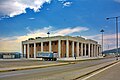
 Thesprotia Regional unit offices building
 -
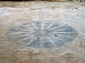 Mosaic depicting the Vergina Sun, Titana archeological site
 -
 The Agios Dionysios island, at the Gulf of Igoumenitsa


See also
References
- ^ a b c "Αποτελέσματα Απογραφής Πληθυσμού - Κατοικιών 2021, Μόνιμος Πληθυσμός κατά οικισμό" [Results of the 2021 Population - Housing Census, Permanent population by settlement] (in Greek). Hellenic Statistical Authority. 29 March 2024.
- doi:10.12681/eadd/43679. Retrieved 13 November 2022.)
{{cite journal}}: Cite journal requires|journal=(help - ^ a b "The history of Igoumenitsa, summarized (original: Η ιστορία της Ηγουμενίτσας περιληπτικά)". Thesprotikos Palmos. 2 July 2019. Retrieved 17 November 2021.
- ISBN 978-0-85177-610-1.
- ^ Κ. Πρέκα – Αλεξανδρή, «Το θέατρο των Γιτάνων (Προκαταρκτική έρευνα)», Αρχαία Θέατρα της Ηπείρου 6, Περιφερειακή Ένωση Δήμων Ηπείρου – Διάζωμα, Αθήνα 2012, σ. 110.
- ^ Σ. Δάκαρης, Θεσπρωτία, Αρχαίες Ελληνικές Πόλεις 15, Αθηναϊκός Τεχνολογικός Όμιλος – Αθηναϊκό Κέντρο Οικιστικής, Ἀθῆναι 1972, σ. 185· Α. Kάντα – Κίτσου, Ο. Πάλλη, Ι. Αναγνώστου, Αρχαιολογικό Μουσείο Ηγουμενίτσας, Υπουργείο Πολιτισμού ΛΒ΄ Εφορία Προϊστορικών & Κλασικών Αρχαιοτήτων Θεσπρωτίας, Ηγουμενίτσα 2008, σ. 54
- ^ "1911-12 Trablusgarp Savaşı'nda Deniz Kuvvetleri". Archived from the original on 2011-07-20. Retrieved 2010-12-13.
- S2CID 144176577.
p until November 13, when the descent of the Italians into Epirus continued along with the retreat of the Greek army south of the Kalamas River, groups of armed Çams accompanied the Italian army and entered the cities of Thesprotia as liberators. That initial brief period of Italian presence in Epirus constituted a foretaste of what was to follow: Filiates, Igoumenitsa, Mourtos were burnt
- ^ Tsoutsoumpis, Spyros (December 2015). "Violence, resistance and collaboration in a Greek borderland: the case of the Muslim Chams of Epirus". Qualestoria (2): 131. Retrieved 14 June 2016.
- ^ Kallivretakis, Leonidas (1995). "Η ελληνική κοινότητα της Αλβανίας υπό το πρίσμα της ιστορικής γεωγραφίας και δημογραφίας [The Greek Community of Albania in terms of historical geography and demography." In Nikolakopoulos, Ilias, Kouloubis Theodoros A. & Thanos M. Veremis (eds). Ο Ελληνισμός της Αλβανίας [The Greeks of Albania]. University of Athens. p.38.
- ISBN 978-3-86153-447-1, p. 498
- ISBN 978-3-86153-447-1, p. 702
- ^ Tsoutsoumpis, Spyros (December 2015). "Violence, resistance and collaboration in a Greek borderland: the case of the Muslim Chams of Epirus". Qualestoria (2): 136. Retrieved 14 June 2016.
- OCLC 611201452.
- OCLC 659564122.
- ^ "ΦΕΚ B 1292/2010, Kallikratis reform municipalities" (in Greek). Government Gazette.
- ^ "Population & housing census 2001 (incl. area and average elevation)" (PDF) (in Greek). National Statistical Service of Greece. Archived from the original (PDF) on 2015-09-21.
- ^ "Egnatia Odos (original Εγνατία Οδός)". Eleutheria. 2 July 2009. Retrieved 17 November 2021.
- ^ "Tornano a Trieste i traghetti con la Grecia". Archived from the original on 2012-10-21. Retrieved 2016-09-28.
- ^ "Thesprotia Tourist Guide - Igoumenitsa". Επιμελιτήριο Θεσπρωτίας - Τουριστικός Οδηγός. Retrieved 3 September 2021.
- ^ "Archeological Museum of Igoumenitsa (original: Αρχαιολογικό Μουσείο Ηγουμενίτσας)". 10 January 2019. Retrieved 17 November 2021.
External links
- Official website (in Greek)
| Regional unit of Arta |  | |
|---|---|---|
| Regional unit of Ioannina | ||
| Regional unit of Preveza | ||
| Regional unit of Thesprotia | ||
| ||
| International | |
|---|---|
| National | |