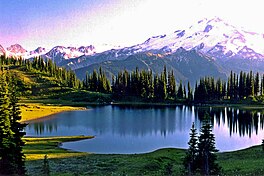
Image Lake
| Image Lake | |
|---|---|
 Image Lake at sunset | |
| Location | Cascade Range, Snohomish County, Washington |
| Coordinates | 48°12′27″N 121°0′30″W / 48.20750°N 121.00833°W |
| Type | Tarn |
| Primary outflows | Miners Creek |
| Catchment area | Skagit River |
| Basin countries | United States |
| Surface area | 3–4 acres (1.2–1.6 ha) |
| Surface elevation | 6,056 ft (1,846 m) |
| References | [1][2][3] |
Image Lake is a tarn in Glacier Peak Wilderness, in the North Cascades of Washington, United States.[1][3] The lake is surrounded by Plummer Peak to the east, a lookout point to the west, the Miners Creek drainage and Glacier Peak to the south, and Canyon Lake to the north.[3][4][5] The course of the popular[4][6] Miners Ridge Trail skirts the lake.[3][5] Glacier Peak can be seen from the outlet of the lake, and the peak reflected in the lake is a popular photographic subject.[4]
As a result of a relatively mild
Hydrology
Image Lake has a drainage basin with an area of less than 1 square mile (2.6 km2). Its primary outflow is a small, unnamed creek that feeds into Miners Creek, which in turn drains into the Suiattle River.[3] The Suiattle River drains into the Skagit River, which in turn empties into Puget Sound.[7] The highest point in the drainage basin is nearly 7,000 feet (2,100 m) above sea level.[3] The lake itself is roughly circular,[3] and has an area of about 3–4 acres (1.2–1.6 ha).[2]
History

There is archaeological evidence that Native Americans had been using the area for at least 8,500 years before present, and had been present at Cascade Pass for at least 9,600 years.[8] Wild game was apparently utilized by Native Americans, and obsidian was exploited since at least 5,000 years before present.[8] They used several routes that passed through the region, and may have used its natural resources during the summer.[9] Some tribes personified the mountains and incorporated them into their religions.[9] Many of these routes followed ridge tops in order to avoid the dense brush and avalanche chutes of the valley bottoms.[8] Horses were also used in the eighteenth century.[9] There was a trail used by Native Americans as a route between Lake Chelan and the Suiattle River valley.[9] The trail apparently traversed Cloudy Pass, which is some distance east of the lake.[6] It was later used by miners and shepherds in the early 1900s.[6] Shepherding was banned on Miners Ridge in 1940, but the popularity of the area continued to grow.[6] Due to the area's popularity, the surrounding meadows deteriorated as a result of livestock grazing and off-trail hiking.[6][10] As a result, livestock were allocated to the nearby Lady Camp Basin and hardier plants were introduced to the area surrounding the lake.[4][6]
Image Lake was originally called "Mirror Lake", but was given its present name on April 10, 1940 by Hugh Ritter and Rudo Fromme, who were employees of the
In 2003, floods washed out large portions of the Suiattle River Road, beginning 12.5 miles (20.1 km) from the trailhead, making Image Lake more accessible from
Hiking

The trail to Image Lake can be accessed from the Suiattle River Road. It can also be accessed from Holden, on the east side of the Cascade crest, west of Lake Chelan.[4][5] The trail begins by following the Suiattle River, eventually reaching open meadows with views of Glacier Peak.[4] There is also an alpine route that leads from the Miners Ridge Trail to Plummer Mountain,[16] and a little used trail that leads to Canyon Lake and Totem Pass,[17] which is about 4 miles (6.4 km) southeast of Dome Peak.[3]
See also
- List of lakes in Washington (state)
References
Footnotes
- ^ a b "Image Lake". Geographic Names Information System. United States Geological Survey, United States Department of the Interior. September 10, 1979. Retrieved July 22, 2013.
- ^ a b c d "Decision Card for Image Lake". United States Forest Service, April 10, 1940. Retrieved October 19, 2013.
- ^ a b c d e f g h Image Lake, WA — N48.19932° W121.01539° (Map). 1:24K. USGS 7.5 minute series. 2008–2013. Retrieved July 28, 2013.
- ^ )
- ^ a b c "Mt. Baker-Snoqualmie National Forest — Miners Ridge Trail 785". United States Forest Service. Retrieved July 22, 2013.
- ^ a b c d e f Smith, Bernard A. (October 27–29, 1978). Written at Portland, Oregon. Recreational Impact on Wildlands: Conference Proceedings. University of Minnesota: Department of Agriculture, Forest Service, Pacific Northwest Region (published 1979). pp. 280–283. Retrieved July 23, 2013.
- ^ Kimbrough, R.A. (March 23, 2006). "Water Resources Data-Washington Water Year 2005" (PDF). United States Geological Survey: 374. Retrieved December 10, 2013.
{{cite journal}}: Cite journal requires|journal=(help) - ^ US National Park Service. October 17, 2013. Retrieved November 9, 2013.
- ^ a b c d Beckey, p. 220
- U.S. Department of Agriculture. Retrieved July 27, 2013.
- ISBN 978-0-918664-00-6.
- ^ )
- Mount Baker-Snoqualmie National Forest. Retrieved August 5, 2013.
- ^ a b Landers, Rich (August 18, 2013). "Should Image Lake be reopened to crowds of hikers?". Outdoors. The Spokesman-Review. Spokane, Washington. Retrieved October 21, 2013.
- ^ Romano, Craig (September 3, 2010). "Hike of the Week for Friday, September 3, 2010". Retrieved October 21, 2013.
- ^ Beckey, p. 383
- ISBN 0-89886-904-8. Retrieved October 24, 2013.
Bibliography
- )
- Kruckeberg, Arthur (1991). The Natural History of Puget Sound Country — Arthur R. Krukeberg — Google Books. )
External links
- Image Lake on the Washington Trails Association website
- New York Times article [1]


