
Indus River
| Indus Sindhu, Mehran Himalayan mountain range. | |
|---|---|
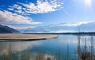
 The course and major tributaries of the Indus river | |
| Location | |
| Country | China, India, Pakistan (Sovereignty in the Kashmir region is disputed.)[2] |
| States or provinces | Tibet Autonomous Region, Ladakh, Gilgit-Baltistan, Khyber Pakhtunkhwa, Punjab, and Sindh |
| Cities | Leh, Kargil, Skardu, Dasu, Besham, Thakot, Swabi, Dera Ismail Khan, Mianwali, Bhakkar, Sukkur, Hyderabad, Karachi |
| Physical characteristics | |
| Source | Lake Manasarovar[3] |
| • location | Tibetan Plateau |
| Source confluence | |
| • location | Shiquanhe, Ngari Prefecture, Tibet Autonomous Region, People's Republic of China |
| • coordinates | 32°29′54″N 79°41′28″E / 32.49833°N 79.69111°E |
| • elevation | 4,255 m (13,960 ft) |
| Mouth | Arabian Sea (primary), Rann of Kutch (secondary) |
• location | Indus River Delta (primary), Pakistan
Indus Delta, Arabian Sea, Pakistan |
| • average | 5,533 m3/s (195,400 cu ft/s)[5] |
| • minimum | 1,200 m3/s (42,000 cu ft/s) |
| • maximum | 58,000 m3/s (2,000,000 cu ft/s) |
| Discharge | |
| • location | Sukkur |
| • average | 5,673.486 m3/s (200,357.3 cu ft/s)[6] |
| Discharge | |
| • location | Mithankot |
| • average | 5,812.326 m3/s (205,260.4 cu ft/s)[6] |
| Discharge | |
| • location | Tarbela Dam |
| • average | 2,469 m3/s (87,200 cu ft/s) |
| Basin features | |
| Tributaries | |
| • left | Kurram River, Gomal River, Zhob River |
The Indus (
The river has a total
The northern part of the Indus Valley, with its tributaries, forms the
Etymology and names
This river was known to the ancient Indians in Sanskrit as Sindhu and to the Persians as Hindu/Həndu which was regarded by both of them as "the border river".[10][11][12][13][14] The variation between the two names is explained by the Old Iranian sound change *s → h, which occurred between 850 and 600 BC according to Asko Parpola.[15][16] From the Persian Achaemenid Empire, the name passed to the Greeks as Indós (Ἰνδός).[17] It was adopted by the Romans as Indus.[18] The name India is derived from Indus.[19][20]
The Ladakhis and Tibetans call the river Senge Tsangpo (སེང་གེ་གཙང་པོ།), Baltis call it Gemtsuh and Tsuh-Fo, Pashtuns call it Nilab, Sher Darya and Abbasin, while Sindhis call it Sindhu, Mehran, Purali and Samundar.[1][21]
The modern name in
Description

The Indus River provides key water resources for
The total length of the river varies in different sources. The length used in this article is 3,180 km (1,980 mi), taken from the Himalayan Climate and Water Atlas (2015).[4] Historically, the 1909 The Imperial Gazetteer of India gave it as "just over 1,800 miles".[23] A shorter figure of 2,880 km (1,790 mi) has been widely used in modern sources, as has the one of 3,180 km (1,980 mi). The modern Encyclopedia Britannica was originally published in 1999 with the shorter measurement, but was updated in 2015 to use the longer measurement.[1] Both lengths are commonly found in modern publications; in some cases, both measurements can be found within the same work.[24] An extended figure of circa 3,600 km (2,200 mi) was announced by a Chinese research group in 2011, based on a comprehensive remeasurement from satellite imagery, and a ground expedition to identify an alternative source point, but detailed analysis has not yet been published.[25]
The ultimate source of the Indus is in
The Indus then flows northwest through Ladakh (Indian-administered Kashmir) and Baltistan and Gilgit (Pakistan-administered Kashmir), just south of the Karakoram range. The Shyok, Shigar and Gilgit rivers carry glacial waters into the main river. It gradually bends to the south and descends into the Punjab plains at Kalabagh, Pakistan. The Indus passes gigantic gorges 4,500–5,200 metres (15,000–17,000 ft) deep near the Nanga Parbat massif. It flows swiftly across Hazara and is dammed at the Tarbela Reservoir. The Kabul River joins it near Attock. The remainder of its route to the sea is in the plains of the Punjab[27] and Sindh, where the flow of the river becomes slow and highly braided. It is joined by the Panjnad at Mithankot. Beyond this confluence, the river, at one time, was named the Satnad River (sat = "seven", nadī = "river"), as the river now carried the waters of the Kabul River, the Indus River and the five Punjab rivers. Passing by Jamshoro, it ends in a large delta to the South of Thatta in the Sindh province of Pakistan.
The Indus is one of the few rivers in the world to exhibit a
History

The major cities of the
Most scholars believe that settlements of
The
The word
The lower basin of the Indus forms a natural boundary between the
Geography

Tributaries
- Gar River
- Gilgit River
- Gomal River
- Haro River
- Hunza River
- Kabul River
- Kunar River
- Kurram River
- Panjnad River
- Chenab River
- Satluj River
- Shyok River
- Soan River
- Dras River (or Shingo River)
- Swat River
- Zanskar River
- Luni river
- Zhob River

Geology


Indus is an antecedent river, meaning that it existed before the Himalayas and entrenched itself while they were rising.
The Indus river feeds the Indus
In the Nanga Parbat region, the massive amounts of erosion due to the Indus river following the capture and rerouting through that area are thought to bring middle and lower crustal rocks to the surface.[40]
In November 2011, satellite images showed that the Indus river had re-entered India and was feeding the Great Rann of Kutch, Little Rann of Kutch and a lake near Ahmedabad known as Nal Sarovar.[30] Heavy rains had left the river basin along with the Lake Manchar, Lake Hemal and Kalri Lake (all in modern-day Pakistan) inundated. This happened two centuries after the Indus river shifted its course westwards following the 1819 Rann of Kutch earthquake.
The Induan Age at the start of the Triassic Period of geological time is named for the Indus region.
Wildlife

Accounts of the Indus valley from the times of Alexander's campaign indicate a healthy forest cover in the region. The Mughal Emperor
Mammals
The
There are two otter species in the Indus River basin: the Eurasian otter in the northeastern highland sections and the smooth-coated otter elsewhere in the river basin. The smooth-coated otters in the Indus River represent a subspecies found nowhere else, the Sindh otter (Lutrogale perspicillata sindica).[44]
Fish
The Indus River basin has high diversity, being the home of more than 180 freshwater fish species,[45] including 22 which are found nowhere else.[41] Fish also played a major role in earlier cultures of the region, including the ancient Indus Valley Civilisation where depictions of fish were frequent. The Indus script has a commonly used fish sign, which in its various forms may simply have meant "fish", or referred to stars or gods.[46]
In the uppermost, highest part of the Indus River basin there are relatively few genera and species: . The large delta has been recognized by conservationists as an important ecological region. Here, the river turns into many marshes, streams and creeks and meets the sea at shallow levels.
Palla fish (Tenualosa ilisha) of the river is a delicacy for people living along the river. The population of fish in the river is moderately high, with Sukkur, Thatta, and Kotri being the major fishing centres – all in the lower Sindh course. As a result, damming and irrigation have made fish farming an important economic activity.
Economy

The Indus is the most important supplier of water resources to the
After Pakistan came into existence, a water control treaty signed between India and Pakistan in 1960 guaranteed that Pakistan would receive water from the Indus River and its two tributaries the Jhelum River and the Chenab River independently of upstream control by India.[47]
The Indus Basin Project consisted primarily of the construction of two main dams, the Mangla Dam built on the Jhelum River and the Tarbela Dam constructed on the Indus River, together with their subsidiary dams.[48] The Pakistan Water and Power Development Authority undertook the construction of the Chashma-Jhelum link canal – linking the waters of the Indus and Jhelum rivers – extending water supplies to the regions of Bahawalpur and Multan. Pakistan constructed the Tarbela Dam near Rawalpindi – standing 2,743 metres (9,000 ft) long and 143 metres (470 ft) high, with an 80-kilometre (50 mi) long reservoir. It supports the Chashma Barrage near Dera Ismail Khan for irrigation use and flood control and the Taunsa Barrage near Dera Ghazi Khan which also produces 100,000 kilowatts of electricity. The Kotri Barrage near Hyderabad is 915 metres (3,000 ft) long and provides additional water supplies for Karachi. The extensive linking of tributaries with the Indus has helped spread water resources to the valley of Peshawar, in the Khyber Pakhtunkhwa. The extensive irrigation and dam projects provide the basis for Pakistan's large production of crops such as cotton, sugarcane and wheat. The dams also generate electricity for heavy industries and urban centres.
People
The Indus river is sacred to Hindus.[50][51] The Sindhu Darshan Festival is held on every Guru Purnima on the banks of the Indus.[52]
The ethnicities of the Indus Valley (Pakistan and Northwest India) have a greater amount of ANI (or West Eurasian) admixture than other South Asians, including inputs from Western Steppe Herders, with evidence of more sustained and multi-layered migrations from the west.[53]
Modern issues
Indus delta
Originally, the delta used to receive almost all of the water from the Indus river, which has an annual flow of approximately 180 billion cubic metres (240×109 cu yd), and is accompanied by 400 million tonnes (390×106 long tons) of silt.
Vegetation and wildlife of the Indus delta are threatened by the reduced inflow of fresh water, along with extensive deforestation, industrial pollution and
Large-scale diversion of the river's water for irrigation has raised far-reaching issues. Sediment clogging from poor maintenance of canals has affected agricultural production and vegetation on numerous occasions. Irrigation itself is increasing soil salinization, reducing crop yields and in some cases rendering farmland useless for cultivation.[62]
Effects of climate change on the river
The Tibetan Plateau contains the world's third-largest store of ice. Qin Dahe, the former head of the China Meteorological Administration, said the recent fast pace of melting and warmer temperatures will be good for agriculture and tourism in the short term, but issued a strong warning:
Temperatures are rising four times faster than elsewhere in China, and the Tibetan glaciers are retreating at a higher speed than in any other part of the world... In the short term, this will cause lakes to expand and bring floods and mudflows... In the long run, the glaciers are vital lifelines of the Indus River. Once they vanish, water supplies in Pakistan will be in peril.[63]
"There is insufficient data to say what will happen to the Indus," says David Grey, the World Bank's senior water advisor in South Asia. "But we all have very nasty fears that the flows of the Indus could be severely, severely affected by glacier melt as a consequence of climate change," and reduced by perhaps as much as 50 per cent. "Now what does that mean to a population that lives in a desert [where], without the river, there would be no life? I don't know the answer to that question," he says. "But we need to be concerned about that. Deeply, deeply concerned."
U.S. diplomat Richard Holbrooke said, shortly before he died in 2010, that he believed that falling water levels in the Indus River "could very well precipitate World War III."[64]
Pollution
Over the years factories on the banks of the Indus River have increased levels of water pollution in the river and the atmosphere around it. High levels of pollutants in the river have led to the deaths of endangered Indus river dolphin. The
The Indus is second among a group of ten rivers responsible for about 90% of all the plastic that reaches the oceans. The Yangtze is the only river contributing more plastic.[69][70]
2010 floods

Frequently, Indus river is prone to moderate to severe flooding.[71] In July 2010, following abnormally heavy monsoon rains, the Indus River rose above its banks and started flooding. The rain continued for the next two months, devastating large areas of Pakistan. In Sindh, the Indus burst its banks near Sukkur on 8 August, submerging the village of Mor Khan Jatoi.[72] In early August, the heaviest flooding moved southward along the Indus River from severely affected northern regions toward western Punjab, where at least 1,400,000 acres (570,000 ha) of cropland was destroyed, and the southern province of Sindh.[73] As of September 2010[update], over two thousand people had died and over a million homes had been destroyed since the flooding began.[74][75]
2011 floods
The 2011 Sindh floods began during the Pakistani monsoon season in mid-August 2011, resulting from heavy monsoon rains in Sindh, eastern Balochistan, and southern Punjab.[76] The floods caused considerable damage; an estimated 434 civilians were killed, with 5.3 million people and 1,524,773 homes affected.[77] Sindh is a fertile region and often called the "breadbasket" of the country; the damage and toll of the floods on the local agrarian economy was said to be extensive. At least 1.7 million acres (690,000 ha; 2,700 sq mi) of arable land were inundated. The flooding followed the previous year's floods, which devastated a large part of the country.[77] Unprecedented torrential monsoon rains caused severe flooding in 16 districts of Sindh.[78]
Barrages, bridges, levees and dams
In Pakistan currently there are six barrages on the Indus: Guddu Barrage, Sukkur Barrage, Kotri Barrage (also called Ghulam Muhammad barrage), Taunsa Barrage, Chashma Barrage and Jinnah Barrage. Another new barrage called "Sindh Barrage" is planned as a terminal barrage on the Indus River.[79][80] There are some bridges on River Indus, such as Dadu Moro Bridge, Larkana Khairpur Indus River Bridge, Thatta-Sujawal bridge, Jhirk-Mula Katiar bridge and recently planned Kandhkot-Ghotki bridge.[81]
The entire left bank of Indus river in Sind province is protected from river flooding by constructing around 600 km long
Gallery
-
Video of River Indus at Kotri Barrage, Sindh, Pakistan.
-
 Lansdowne Bridge and Ayub Bridge connecting the cities of Rohri and Sukkur in Sindh, Pakistan.
 -
 Frozen Indus, Near Nyoma
 -
 Indus at Skardu
 -
 Indus near Dera Ismail Khan


.jpg)

Tourism
See also
Explanatory notes
- ^ Number of Indus script inscribed objects and seals obtained from various Harappan sites: 1540 from Mohanjodaro, 985 from Harappa, 66 from Chanhudaro, 165 from Lothal, 99 from Kalibangan, 7 from Banawali, 6 from Ur in Iraq, 5 from Surkotada, 4 from Chandigarh
Citations
- ^ Encyclopedia Britannica. Retrieved 5 February 2021.
- ^ a b "Kashmir: region, Indian subcontinent". Encyclopædia Britannica. Retrieved 16 July 2016. Quote: "Kashmir, region of the northwestern Indian subcontinent. It is bounded by the Uygur Autonomous Region of Xinjiang to the northeast and the Tibet Autonomous Region to the east (both parts of China), by the Indian states of Himachal Pradesh and Punjab to the south, by Pakistan to the west, and by Afghanistan to the northwest. The northern and western portions are administered by Pakistan and comprise three areas: Azad Kashmir, Gilgit, and Baltistan, ... The southern and southeastern portions constitute the Indian state of Jammu and Kashmir. The Indian- and Pakistani-administered portions are divided by a "line of control" agreed to in 1972, although neither country recognizes it as an international boundary. In addition, China became active in the eastern area of Kashmir in the 1950s and since 1962 has controlled the northeastern part of Ladakh (the easternmost portion of the region)."
- S2CID 125980503.
- ^ ISBN 978-92-9115-357-2.
- ^ Amir, Khan; Naresh, Pant; Anuj, Goswami; Ravish, Lal; Rajesh, Joshi (December 2015). "Critical Evaluation and Assessment of Average Annual Precipitation in The Indus, The Ganges and The Brahmaputra Basins, Northern India – Himalayan Cryospheric Observations and Modelling (HiCOM)".
- ^ a b "Rivers Network". 2020.
- Encyclopedia Britannica. Retrieved 9 August 2021.
historic region and autonomous region of China that is often called "the roof of the world." It occupies a vast area of plateaus and mountains in Central Asia
- ISBN 978-1-4654-9492-4.
- ^ "Indus water flow data in to reservoirs of Pakistan". Archived from the original on 6 August 2017. Retrieved 15 August 2017.
- ISBN 978-3-11-014447-5.
- ISBN 9780853312550.: "As the great frontier river that represents the natural dividing line between India and Iran, the Indus could most easily and fittingly be called Sindhu- 'Frontier' by the Indians and Hindu- 'Frontier' by the Iranians."
- ISBN 978-81-7304-682-7.: 'P. Theme (1991) understood the Indus as the "border river" dividing IA and Iran. tribes and has derived it from IE with an etymology from the root "si(n)dh" to divide."'
- ISBN 978-90-04-08847-4.: "The word hindu- (Skt. sindhu-), used thus to mean a river-frontier of the inhabited world, was also applied generally, it seems, to any big river which, like the Indus, formed a natural frontier between peoples or lands."
- S2CID 163083563.: "The word sindhu- is used of a 'mass of water' (samudra-), not therefore primarily 'flowing' water. Hence the second derivation of 'enclosed banks' is clearly preferable."
- ^ Parpola 2015, Chapter 9.
- ISBN 978-1-351-80655-8.
- ISBN 978-81-87498-26-1.: "Apparently the same territory was referred to as Hi(n)du(sh) in the Naqsh‐i‐Rustam inscription of Darius I as one of the countries in his empire. The terms Hindu and India ('Indoi) indicate an original indigenous expression like Sindhu. The name Sindhu could have been pronounced by the Persians as Hindu (replacing s by h and dh by d) and the Greeks would have transformed the latter as Indo‐ (Indoi, Latin Indica, India) with h dropped..."
- ^ Charlton T Lewis; Charles Short (1879). A Latin Dictionary. New York, N.Y.; Cincinnati, Ohio; Chicago, Ill.: American Book Company; Oxford: Clarendon Press. p. sv. Indus.
- ^ India (noun), Oxford English Dictionary, 3rd Edition, 2009 (subscription required)
- ISBN 978-0-85331-255-0
- ^ Albinia, Alice (28 August 2008). "The guardian first book award longlist: Empires of the Indus by Alice Albinia". the Guardian. Retrieved 19 May 2022.
- ^ McGregor, Ronald Stuart (1993). The Oxford Hindi-English Dictionary, London: Oxford University Press. p. 1012.
- ^ Imperial Gazetteer of India. Vol. 13. Oxford University Press. 1909. p. 357.
- ISBN 0195779053. Papers in this edited collection generally use the shorter measurement, but at least two use the longer one.
- ^ a b "Earthly matters: Origins of the Indus". Dawn. 4 September 2011.
- ^ Albinia (2008), p. 307.
- ^ Holdich, Thomas Hungerford (1911). . In Chisholm, Hugh (ed.). Encyclopædia Britannica. Vol. 14 (11th ed.). Cambridge University Press. pp. 507–508.
- ^ 70% of cattle-breeders desert Banni Archived 3 April 2019 at the Wayback Machine; by Narandas Thacker, TNN, 14 February 2002; The Times of India
- ^ "564 Charul Bharwada & Vinay Mahajan, Lost and forgotten: grasslands and pastoralists of Gujarat".
- ^ a b "Indus re-enters India after two centuries, feeds Little Rann, Nal Sarovar". Retrieved 22 December 2017.
- ISBN 978-1406298574.
- ISBN 978-81-7335-498-4.
- ^ Iravatham Mahadevan, 1977, The Indus Script: Text, Concordance and Tables, pp. 6–7
- ^ Upinder Singh, 2008, A History of Ancient and Early Medieval India From the Stone Age to the 12th Century Archived 29 November 2022 at the Wayback Machine, p. 169
- ^ Henry Yule: India, Indies Archived 28 June 2012 at archive.today. In Hobson-Jobson: A glossary of colloquial Anglo-Indian words and phrases, and of kindred terms, etymological, historical, geographical and discursive. New ed. edited by William Crooke, B.A. London: J. Murray, 1903
- ^ "Was the Ramayana actually set in and around today's Afghanistan?". 26 April 2015.
- S2CID 129735252.
- S2CID 4427250.
- .
- .
- ^ a b "Indus River" (PDF). World' top 10 rivers at risk. WWF. Archived from the original (PDF) on 4 October 2012. Retrieved 11 July 2012.
- ^ "Indus River Dolphin | Species | WWF". World Wildlife Fund. Retrieved 29 January 2023.
- ^ Fisheries, NOAA (15 September 2022). "Indus River Dolphin | NOAA Fisheries". NOAA. Retrieved 29 January 2023.
- ^ Khan, W.A.; Bhagat, H.B. (2010). "Otter Conservation in Pakistan". IUCN Otter Spec. Group Bull. 27 (2): 89–92.
- ^ a b c d e f g Mirza, M.R.; Mirza, Z.S. (2014). "Longitudinal Zonation in the Fish Fauna of the Indus River in Pakistan". Biologia (Pakistan). 60 (1): 149–152.
- ^ Sparavigna, A. (2008). Icons and signs from the ancient Harappa. Dipartimento di Fisica, Politecnico di Torino.
- ^ "Tarabela Dam". structurae.the cat in the hat. Retrieved 9 July 2007.
- ^ "Indus Basin Project". Encyclopædia Britannica. Retrieved 9 July 2007.
- ^ Caron, Sarah. "The Last Mohana People". Le Figaro Magazine. Retrieved 19 April 2023.
- ISBN 978-81-7755-267-6.
- ISBN 978-81-307-0533-0.
- ^ "Corona effect: Only Sindhis allowed for Sindhu Darshan Fest". Retrieved 24 October 2020.
- PMID 30526867.
- ^ "Indus Delta, Pakistan: economic costs of reduction in freshwater flow" (PDF). International Union for Conservation of Nature. May 2003. Archived from the original (PDF) on 16 November 2011. Retrieved 9 July 2018.
- ^ Sarfraz Khan Quresh (March 2005). "Water, Growth and Poverty in Pakistan" (PDF). World Bank.
- ^ "Pakistan's water economy: getting the balance right". July 2018.
- ^ Walsh, Declan (21 October 2010). "Pakistan floods: The Indus delta". The Guardian.
- ^ Walsh, Declan (5 October 2010). "Pakistan's floodwaters welcomed along Indus delta". The Guardian.
- ^ Keller, Jack; Keller, Andrew; Davids, Grant (January 1998). "River basin development phases and implications of closure". Retrieved 25 September 2020.
- ^ "Integrated Water Resource Systems: Theory and Policy Implications" (PDF). Retrieved 22 June 2018.
- World Wildlife Fund. Archived from the originalon 23 January 2012.
- ^ "Technology Breakthroughs for Global Water Security: A Deep Dive into South Asia". 12 September 2018. Retrieved 24 December 2018.
- ^ "Global warming benefits to Tibet: Chinese official. Reported 18 August 2009". 17 August 2009. Archived from the original on 23 January 2010. Retrieved 4 December 2012.
- ISBN 978-0393652109.
- ^ "SEPA orders polluting factory to stop production". Dawn. 3 December 2008. Retrieved 28 June 2012.
- ^ "Fishing poison killing Indus dolphins, PA told". Dawn. 8 March 2012. Retrieved 27 April 2016.
- ^ "18 dolphins died from poisoning in Jan". Dawn. 1 May 2012. Retrieved 28 June 2012.
- ^ "Threat to dolphin: Govt bans fishing between Guddu and Sukkur". The Express Tribune. 9 March 2012. Retrieved 28 June 2012.
- ^ "Almost all plastic in the ocean comes from just 10 rivers – 30.11.2017". DW.COM. Retrieved 22 August 2018.
about 90 per cent of all the plastic that reaches the world's oceans gets flushed through just 10 rivers: The Yangtze, the Indus, Yellow River, Hai River, the Nile, the Ganges, Pearl River, Amur River, the Niger, and the Mekong (in that order).
- PMID 29019247.
- ^ "Indus Basin Floods" (PDF). Asian Development Bank. 2013. Retrieved 20 November 2018.
- ^ Bodeen, Christopher (8 August 2010). "Asia flooding plunges millions into misery". Associated Press. Retrieved 8 August 2010.
- ^ Guerin, Orla (7 August 2010). "Pakistan issues flooding 'red alert' for Sindh province". British Broadcasting Corporation. Retrieved 7 August 2010.
- ^ "BBC News – Pakistan floods: World Bank to lend $900m for recovery". bbc.co.uk. 17 August 2010. Retrieved 24 August 2010.
- ^ "BBC News – Millions of Pakistan children at risk of flood diseases". bbc.co.uk. 16 August 2010. Retrieved 24 August 2010.
- ^ "Pakistan floods: Oxfam launches emergency aid response". BBC World News South Asia. 14 September 2011. Retrieved 15 September 2011.
- ^ a b "Floods worsen, 270 killed: officials". The Express Tribune. 13 September 2011. Retrieved 13 September 2011.
- ^ Government of Pakistan Pakmet.com.pk Retrieved on 19 September 2011 Archived 24 April 2012 at the Wayback Machine
- ^ "PM okays Indus river barrage to mitigate water woes". Retrieved 8 August 2019.
- ^ "Center announces Rs125bn Sindh barrage project". Retrieved 24 August 2019.
- ^ "Government to launch Kandhkot-Ghotki bridge over River Indus next month: Sindh CM". The Express Tribune. Retrieved 1 August 2016.
- ^ "Restore Pakistan's rivers, handle floods, droughts and climate change". 23 August 2016. Retrieved 29 July 2019.
- ^ "Pakistan: Getting More from Water (see Page 50)" (PDF). World Bank. Retrieved 29 March 2019.
- ^ "The Summit Adventure ladakh". www.ladakhs.com. Archived from the original on 5 April 2010.
- ^ Sindhu Pushkaram festival, accessed 27 July 2023.
General and cited references
- Albinia, Alice. (2008) Empires of the Indus: The Story of a River. First American Edition (20101) W. W. Norton & Company, New York. ISBN 978-0-393-33860-7.
- Alexander Burnes, A voyage on the Indus, London, 1973
- Philippe Fabry, Wandering with the Indus, with Yusuf Shahid (text) Lahore, 1995
- Jean Fairley, The Lion River: The Indus, London, 1975
- G.P. Malalasekera (1 September 2003). Dictionary of Pali Proper Names. Vol. 1. Asian Educational Services. ISBN 978-81-2061-823-7.
- D. Murphy, Where the Indus is Young, London, 1977
- Parpola, Asko (15 July 2015). The Roots of Hinduism: The Early Aryans and the Indus Civilization. Oxford University Press. ISBN 978-0-19-022693-0.
- Samina Quraeshi, Legacy of the Indus, New York, 1974
- Schomberg, Between Oxus and Indus, London, 1935
- Francine Tissot, Les Arts anciens du Pakistan et de l'Afghanistan, Paris, 1987
- Sir M. Wheeler, Civilisations of the Indus Valley and Beyond, London, 1966
- World Atlas, Millennium Edition, p. 265.
External links
This section's use of external links may not follow Wikipedia's policies or guidelines. (April 2020) |
 Definitions from Wiktionary
 Media from Commons
 News from Wikinews
 Quotations from Wikiquote
 Texts from Wikisource
 Textbooks from Wikibooks
 Resources from Wikiversity
- The origins of Indus:
- 1159539 Gar basin on OpenStreetMap
- 1159538 Sengge basin on OpenStreetMap
- Northern Areas Development Gateway
- The Mountain Areas Conservancy Project – covered parts of the Indus River
- Indus River watershed map (World Resources Institute) Archived 13 April 2005 at the Wayback Machine
- Indus Wildlife at the Wayback Machine (archived 7 October 2006)
- Pulitzer Center on Crisis Reporting's project on water issues in South Asia
| |||||||
| Yangtze system | |
|---|---|
| Yellow system | |
Pearl system | |
| Heilongjiang system | |
| Huai system | |
| Hai system | |
| Liao system | |
| Other major rivers | |
| Major canals | |
| Sovereign states |
|
|---|---|
| States with limited recognition |
|
| Dependencies and other territories |
|
| International | |
|---|---|
| National | |
| Geographic | |
| Other | |