
Inman Valley, South Australia
| Inman Valley Federal division(s) | Mayo[7] | ||||||||||||||
|---|---|---|---|---|---|---|---|---|---|---|---|---|---|---|---|
| |||||||||||||||
| |||||||||||||||
| Footnotes | Adloining localities[1] | ||||||||||||||
Inman Valley is a locality in the Australian state of South Australia located on the Fleurieu Peninsula about 86 kilometres (53 mi) south of the state capital of Adelaide. The valley is about 380 square kilometres (150 sq mi) in area. At the 2016 census, Inman Valley had a population of 343.[2]
Origin of the name
Inman Valley, and
History

The first recorded Europeans to sight the valley were likely the party that accompanied explorer Collet Barker (but not Barker himself) in 1831. In its pristine state the valley abounded in kangaroos, which were hunted for food by early sealers and whalers at Encounter Bay.
Inman Valley was surveyed in late 1839 by a party under Senior Surveyor N. Lipscomb Kentish, formerly of
Immediately following the completion of surveys the land was opened for selection and in early 1840 the first European settlers to establish a homestead at Inman Valley were the three young James brothers: William Rhodes James, John Vidal James and
The other contenders at being first residents of Inman Valley, around the same time, are the brothers Thomas Bewes Strangways and Giles Edward Strangways, but their land was near the mouth of the valley at Encounter Bay. Other pioneering settlers promptly joined them, including William Robinson, the latter being the first to drive a horse and cart over Mount Terrible.[16] Other settlers soon followed, such as John Lush.
Although various crops flourished, and sheep were successful, from the very earliest years cattle were known to thrive at Inman Valley and so they predominated. By the 1880s this led to an extensive dairying industry, including butter and cheese production, with a butter factory being established in 1890.
Present-day land use is predominantly grazing, dairy farming, forestry and horticulture. The valley area also attracts bushwalkers and tourists.[17]
Selwyn Rock
In the valley is Selwyn Rock (35°29′47″S 138°30′45″E / 35.4965°S 138.5124°E) a
Gallery
-
 Interpretive sign at Selwyn Rock marking Selwyn's discovery of glaciation in Australia
 -
 Selwyn Rock – grooves and striations on exhumed Permian glacial pavement
 -
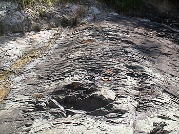 Selwyn Rock – grooves and striations on exhumed Permian glacial pavement
 -
 Selwyn Rock – granite glacial erratic eroding out of unconsolidated Permian till
 -
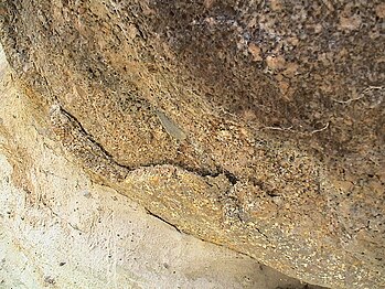 Selwyn Rock – Weathering rind of large granite glacial erratic eroding out of unconsolidated Permian till
 -
 Selwyn Rock – faceted pebble eroding out of unconsolidated Permian till


References
- ^ a b c d e "Search results for 'Inman Valley, LOCB' with the following datasets being selected – 'Suburbs and Localities', 'Counties', 'Local Government Areas', 'SA Government Regions' and 'Gazetteer'". Location SA Map Viewer. Government of South Australia. Retrieved 6 March 2019.
- ^ a b Australian Bureau of Statistics (27 June 2017). "Inman Valley (State Suburb)". 2016 Census QuickStats. Retrieved 6 March 2019.
- ^ "Postcode for Inman Valley, South Australia". Retrieved 6 March 2019.
- ^ "Fleurieu Kangaroo Island SA Government region" (PDF). The Government of South Australia. Retrieved 17 April 2017.
- ^ Finniss (Map). Electoral District Boundaries Commission. 2016. Retrieved 2 March 2018.
- ^ Mawson (Map). Electoral District Boundaries Commission. 2016. Retrieved 2 March 2018.
- ^ "Profile of the electoral division of Mayo (SA)". Australian Electoral Commission. 20 July 2018. Retrieved 4 March 2019.
- ^ Commonwealth of Australia, Bureau of Meteorology. Retrieved 4 March 2019.
- ^ Inman: first commander of the SA Police / Max Slee. Seaview Press, Adelaide 2010, pp 80-84
- ^ Cockburn, p106, and HM Cooper (SA Museum)
- ^ Manning, p.95
- ^ Register newspaper, 18 June 1857, page 3
- ^ Register newspaper, 19 November 1842, page 3
- ^ Harrison, Susan (ed.): The Journal of William Rhodes James, etc. https://www.repository.cam.ac.uk/bitstream/handle/1810/254143/wrj%20journal%20full.pdf;sequence=1
- ^ Notes from the Southern Autrralia Northern Pioneers' composite, 1850-1859. State Library of South Australia, General Collection, Pictorial Collection, B 6912/H1. Richard Boucher James (1822-1908)[1]
- ^ Burra Record, 28 October 1884, p. 3.
- ^ The Inman Valley Story / Adrian Lush (Ambrose Press, 1971)
- ^ Alley, N.F.. (1995): Late Palaeozoic. In: Drexel, J.F. & Preiss, W.V. (Eds.) The geology of South Australia. Vol.2, The Phanerozoic. p. 63. South Australia Geological Survey, Bulletin 54.
- ^ Bourman, R.P.; Milnes, A.R. (2016). The Geology and Landforms of the Inman River Catchment.