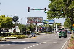
International Drive
This article needs additional citations for verification. (July 2011) |
| I-Drive | |
 International Drive, Orlando FL (April 2011) | |
| Length | 11.1 mi (17.9 km) |
|---|---|
| South end | |
| Major junctions | |
| North end | Oak Ridge Road |
International Drive, commonly known as I-Drive, is a major 11.1-mile (17.9 km)
Route description
International Drive stretches approximately 11.1 miles, with the northern part extending into the southernmost city limits of
I-Drive has four lanes, two in each direction, from its north end at Oak Ridge Road to Pointe Plaza Dr. (former Universal Blvd. south end; see below), and again between the northern and southern intersections with Westwood Blvd. It has six lanes, three in each direction, from Pointe Plaza Dr. to the Beachline Expressway (the eastbound ramps to the Beachline tie into the northern intersection with Westwood Blvd.), and again from the southern intersection with Westwood Blvd. to its end at SR 536. The entirety of International Drive South, from SR 535 to US 192, is entirely six lanes. The section of I-Drive from Universal Blvd. to Sand Lake Road has no median or center turn lane, and frequently has heavy traffic and gridlock in the evenings in the tourism corridor, affecting Carrier Dr. and Sand Lake Road.
The International Drive area is home to the wax museum
Public transportation
The I-Ride Trolley system operated by the International Drive Master Transit & Improvement District provides bus transportation along the I-Drive Resort Area primarily for tourists, convention attendees, and locals alike. Several Lynx public bus routes also serve the I-Drive area with routes to Orlando International Airport, Downtown Orlando and other parts of the city.
History
The first section of I-Drive was laid out in the 1960s by attorney Finley Hamilton to serve his Hilton Inn South, opened in May 1970. He imagined that once Walt Disney World opened in October 1971, tourists would spot the hotel when traveling to the park along Interstate 4. "They called the hotel 'Finley's Folly' – everyone, all of my friends," Hamilton said. "They said it was in the boondocks. ...But it turned out to be highly successful. ...I came up with International Drive," he recalled, "because it sounded big and important."[1] International Drive was eventually extended to its current north point (where Prime Outlets is now) and southward past the Beachline Expressway.
The International Drive Master Transit and Improvement District[2] was created in 1992 to provide growth management, transportation, and infrastructure development for the area with collaboration between the local governments and I-Drive businesses. One of the most critical projects presented to the organization is to create an efficient transportation system for tourists on the I-Drive strip; this prompted the creation of the I-Ride bus trolley system.
Universal Boulevard
Universal Boulevard runs roughly parallel to International Drive from the Beachline Expressway north, then crosses I-Drive and intersects I-4 via an overpass into the
Southbound, it originally fed into International Drive just north of the Orange County Convention Center (the current West Building). The north corner of the intersection is now the Pointe Orlando shopping district. When the North Building (then Phase V) of the OCCC was planned, it was also planned to extend Universal Boulevard along its current alignment on the north side of the North Building. Plans were made in conjunction with the Williamsburg subdivision to design the intersection at the Beachline Expressway so that traffic would not inadvertently clog Orangewood Boulevard, which already met the Beachline at that point (Exit 2). The extension was opened in early 2003, and the old connector to I-Drive at Pointe Orlando was renamed Pointe Plaza Avenue. An electric sign system on the Beachline directs convention-goers to the proper road so as to avoid unnecessary traffic on I-Drive.
Universal Boulevard has fewer businesses, thus much less traffic serving as an overflow exit road for the Orange County Convention Center during major events. Several planned communities and extended-stay business apartments are planned for the corridor, including the Village of Imagine, across from the OCCC North Building. The University of Central Florida opened the off-campus Rosen College of Hospitality Management, funded by local hotelier Harris Rosen, in 2005 at Universal Blvd. and the Beachline. Universal Blvd. is currently six lanes from Vineland Rd. southbound to International Drive, then four lanes southbound to Pointe Plaza Ave., then six lanes again to the Beachline. Only one lane in each direction passes under the Beachline to connect to Orangewood Blvd., which is four lanes on the other side.
Major junctions
| County | Location | mi | km | Destinations | Notes | ||
|---|---|---|---|---|---|---|---|
| Osceola | | 0.0 | 0.0 | ||||
| | 0.9 | 1.4 | |||||
| Orange | | 3.0 | 4.8 | ||||
| Gap in route | |||||||
| | 3.0 | 4.8 | SR 417 exit 6 | ||||
| | 7.4 | 11.9 | Central Florida Parkway | Access to SeaWorld | |||
| | 8.4 | 13.5 | SR 528 exit 1 | ||||
| | 10.8 | 17.4 | |||||
| Orlando | 12.2 | 19.6 | |||||
| 13.3 | 21.4 | Oak Ridge Road | |||||
| Orlando International Premium Outlets | |||||||
| 1.000 mi = 1.609 km; 1.000 km = 0.621 mi | |||||||
References
- ^ "I-drive: How It Grew". Orlando Sentinel. June 13, 2005.
- ^ "International Drive Improvement District". International Drive Master Transit & Improvement District.
