
Interstate 78 in New York
Interstate 78 | ||||
|---|---|---|---|---|
 Map of Lower Manhattan with I-78 highlighted in red | ||||
| Route information | ||||
| Maintained by PANYNJ | ||||
| Length | 0.5 mi[1] (800 m) | |||
| Existed | 1978–present | |||
| NHS | Entire route | |||
| Restrictions | No hazardous goods allowed in the Holland Tunnel | |||
| Major junctions | ||||
| West end | ||||
| East end | Canal Street in Tribeca | |||
| Location | ||||
| Country | United States | |||
| State | New York | |||
| Counties | New York | |||
| Highway system | ||||
| ||||

Interstate 78 (I-78) is a part of the Interstate Highway System that runs from Union Township, Lebanon County, Pennsylvania, to New York City. In the US state of New York, I-78 extends 0.5 miles (0.80 km). The entirety of I-78 consists of the Holland Tunnel, which crosses under the Hudson River from New Jersey and ends at an exit rotary in Lower Manhattan. The tunnel and its approaches are maintained by the Port Authority of New York and New Jersey (PANYNJ).
I-78 was planned to take a longer route when the Interstate System within New York City was originally proposed in the late 1950s. The proposed route of I-78 was to head east via the
Route description

The section of I-78 within New York is 0.5 miles (0.80 km) long according to the
The exit plaza, referred to the "Holland Tunnel Rotary", is in a square superblock that previously housed the
There are four auxiliary routes of I-78 in New York; none of these spurs connect with I-78 because parts of I-78, I-278, and I-478 were not built.
History
Existing segment
When the Interstate numbering was finalized in the late 1950s, the
Only two sections of I-78 in Queens and the Bronx were built. When the Throgs Neck Bridge and its approaches opened in early 1961, they were signed as I-78. The lack of expressway names on the signs, as specified by federal standards, caused confusion among drivers who knew the highways by their names.[24][25] The Clearview Expressway was completed to its present extent in mid-1963,[26] and a short eastbound-only piece of the Nassau Expressway opened in 1971.[27] The unbuilt sections of the Lower Manhattan, Bushwick, and Clearview expressways were canceled by the New York state government in March 1971.[28]
The route of part of the Clearview Expressway's unbuilt southern section later became the JFK Expressway, which connects JFK Airport with the Nassau Expressway, Conduit Avenue (NY 27), and the Belt Parkway.[29] The 2.5-mile (4.0 km) JFK Expressway was completed in 1991.[30]
Canceled segments

Lower Manhattan Expressway
Lower Manhattan Expressway | |
|---|---|
I-478 (Manhattan Bridge) at the East River | |
| Location | |
| Country | United States |
| State | New York |
| Highway system | |
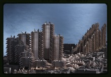
The Lower Manhattan Expressway, also known as LOMEX or the Canal Street Expressway, was a controversial plan for an expressway through Lower Manhattan. The Lower Manhattan Expressway would have begun at the West Side Elevated Highway on the west side of Manhattan, where it would have merged with I-78 at the eastern portal of the Holland Tunnel. From here, the LOMEX would have proceeded generally southeastward as a 10-lane elevated highway, carrying I-78 over what became SoHo and Little Italy. At Centre Street, near the eastern edge of Little Italy, the highway would have split into two branches that both led to bridges over the East River on Manhattan's east side. The main branch would continue southeast as I-78 to the Williamsburg Bridge, while the other would head south to the Manhattan Bridge as I-478. The Manhattan Bridge Spur would have been located above Chrystie Street. The spur to the Williamsburg Bridge would have been mostly depressed or underground, running between Delancey and Broome streets and passing under the Chrystie Street Connection of the New York City Subway.[31] As part of the project, a third tube to the Holland Tunnel would have been built to provide sufficient capacity for the proposed expressway traffic.[32]
The expressway was originally conceived by urban planner and
The expressway plan encountered logistical issues even before they had been fully approved.[37] After the Planning Commission had approved the expressway proposal, the city moved to evict 2,000 families in 416 buildings along the expressway's route, as well as displace 804 businesses.[36] However, residents started organizing protests against the relocation plan.[37] In response, Mayor Robert F. Wagner Jr. told the affected residents that the timeline for starting construction had not yet been finalized, and so they would not need to move for some time.[38] Opposition also formed over the fact that the highway would create a "Chinese wall" separating the neighborhoods of Lower Manhattan.[39] Members of the affected communities, led by community activist Jane Jacobs, formed groups to protest against LOMEX. Jacobs chaired the Joint Committee to Stop the Lower Manhattan Expressway, which recruited such members as Margaret Mead, Eleanor Roosevelt, Lewis Mumford, Charles Abrams, and William H. Whyte.[40]: 24 In his book about the dispute between Jacobs and Moses, the author Anthony Flint stated that newspapers such as The New York Times typically reported Moses's work favorably, while the newly created The Village Voice covered community rallies and advocated against the expressway.[40]: 83–84 Jacobs continued to fight the expressway throughout the rest of the decade, and she was locally seen as a hero for her opposition to the project.[41]: 117
By 1961, Moses had initiated two large federal initiatives to demolish fourteen blocks along Broome Street in Little Italy and SoHo. Moses's plan, funded as "slum clearance" by Title I of the Housing Act of 1949, also called for multiple blocks to be razed and replaced with upscale highrises.[36] The plan ultimately required 132 families to move out, as well as displaced 1,000 small businesses, who relocated to what is now Washington Square Village.[41]: 50–52 In April 1962, Wagner commenced the acquisition of property for the Lower Manhattan Expressway.[42] After further issues with relocation arose in August 1962, Wagner delayed final action on the proposal until after that year's November general elections.[43] A report on the relocation process was published on December 3 of that year. The report stated that the 1,972 families could possibly be relocated without much difficulty.[44] Two days later, there was a tumultuous six-hour-long special executive session of the New York City Board of Estimate on the second floor of New York City Hall, where city officials voted unanimously to block the planned expressway.[45] This served only as a temporary deterrent against the expressway plans, and, in May 1963, Moses announced a revised proposal.[46]
A short 156-foot (48 m) section of the Williamsburg Bridge spur directly under Chrystie Street, with its southern edge aligned with the northern sidewalk of Broome Street, was built during this time.[47] In December 1960, the New York state government started tendering bids to construct this segment.[48] The low bid of about $1.02 million (equivalent to $7.95 million in 2023[35]) was accepted on January 26, 1961,[49] and the road was completed by January 1964.[50] This piece of the highway had cost $941,000 (equivalent to $7.07 million in 2023[35]) to construct. It was necessitated because, in case the expressway was ever completed, the tunnel segment would provide structural support to the Chrystie Street Connection. Ultimately, this segment of tunnel was never used since the expressway was later canceled.[47]
The argument over the Lower Manhattan Expressway became a pivotal argument in the 1965 New York City mayoral election.[51][52] Mayor Wagner supported the construction of the expressway and wanted for the highway to be completed by 1971.[53][52] His opponent, John Lindsay, objected to the elevated highway plan; in July 1965, he filed a lawsuit to postpone any decisions on the expressway until after the election that November.[54] The Port Authority, which operated the Holland Tunnel, also opposed the proposed link because it would put congestion back onto the Holland Tunnel, which had seen moderate traffic flows for the first time since its 1927 opening.[52] Lindsay ultimately won the election and immediately began looking to modify the project's routing.[55] The Regional Plan Association suggested that the city build the expressway underground or in an open cut, instead of an elevated highway.[56] However, Moses opposed the construction of a depressed highway since the same number of buildings would have to be demolished compared to an elevated highway.[57] Deputy Mayor Robert Price subsequently announced that it had stopped pursuing the Lower Manhattan Expressway in any form;[58] however, the Lindsay administration itself was still conducting studies on a possible underground routing.[59] After considerable disagreement with the Lindsay administration, Moses was removed from his position as the city's arterial-road planner in July 1966.[60] Lindsay also commissioned private consultants to perform a study on the Lower Manhattan Expressway, and, in November 1966, they concluded that the expressway plan was not the optimal solution for Lower Manhattan congestion.[61]
In January 1967, Lindsay and Governor Nelson Rockefeller agreed to commission a study of the feasibility of an underground highway rather than an elevated highway.[62] The engineering study was completed that March; it called for various sections to be built in tunnels and open cuts under Broome and Chrystie streets, with a short section west of Sixth Avenue on an elevated structure. The underground highway would have to pass underneath existing subway lines before rising on elevated ramps to connect with the Manhattan Bridge. There would only be two exits, located at the Manhattan Bridge and at Sixth Avenue; the Williamsburg Bridge spur had been dropped by this point. The plan failed to placate Lower Manhattan residents who had opposed the first two proposals since they had been promised that the entire highway would be located underground.[39] Despite the persistent opposition, the federal and state governments allocated funding for the expressway in September 1967.[63] Lindsay announced in April 1968 that he wanted to start construction on the updated Lower Manhattan Expressway as soon as possible.[64] However, the tunnel proposal also encountered difficulties: in January 1969, a group of scientists stated that carbon monoxide levels around the tunnel would be dangerously high,[65] and, the next month, several officials succeeded in delaying the expressway plans.[66]
Bushwick Expressway

Although the Lower Manhattan Expressway caused the most controversy, the first I-78 segment to be canceled was the Bushwick Expressway, which would have linked the Williamsburg Bridge to the Nassau Expressway. The original route would have utilized

The Bushwick Expressway was proposed around 1954 and included in the Port Authority's Joint Study of Arterial Facilities in 1955.[75] The Wyckoff Avenue route was proposed in the 1960s.[67][68][69] At this time, the TBTA envisioned the main route as an eight-lane highway, while the Williamsburg Bridge and Midtown Tunnel spurs would support six lanes of traffic.[69] As with LOMEX, residents along the Bushwick Expressway's route opposed the project because it would necessitate the destruction of residences and businesses in Brooklyn and Queens;[76] the TBTA estimated that nearly 4,000 families would be displaced by the expressway.[69] At the urging of Mayor John Lindsay, the Cross Brooklyn Expressway, which would connect to the Verrazzano-Narrows Bridge and not provide a link in I-78, was substituted for the Bushwick Expressway in 1967 in order to reduce traffic into Manhattan[70][77][78] and because it would reduce the displacement of residents and businesses.[76]
Cancelation of all I-78 expressways
While campaigning for reelection in 1969, Mayor Lindsay canceled plans for the Lower Manhattan and Cross Brooklyn expressways, citing lack of community support.[70][79][80] Lindsay declared the Lower Manhattan Expressway to be "dead for all time",[81] and the Board of Estimate officially voted to erase the proposed expressway from city maps in August.[82] All three unbuilt expressways along the path of I-78 were deleted at the state level by Governor Rockefeller in March 1971.[28]
Effective January 1, 1970,
Robert Moses had planned to build three other expressways through Manhattan, two of which were never constructed as planned. The
A 2015 Gothamist article cites singer Bob Dylan as being partially responsible for the eventual cancelation of the Lower Manhattan Expressway. In 1963, Dylan was said to have written a song called "Listen, Robert Moses" that protested Moses's plans for a superhighway. Though experts were skeptical about the existence of the song and the New York Public Library does not have any records containing the song, Jane Jacobs's son, Jim, confirmed that Dylan had written it and a copy of the lyrics was found in the Tuli Kupferberg collection of the Fales Library of New York University.[92][93]
Exit list
The New York section of I-78 only consists of Holland Tunnel and its entrance and exit ramps. There are five eastbound exit ramps, which are
The entire route is in the
| Location | mi[94] | km | Exit | Destinations | Notes |
|---|---|---|---|---|---|
| Hudson River | 0.0 | 0.0 | – | New Jersey state line at the river's center | |
| 0.0– 0.8 | 0.0– 1.3 | Holland Tunnel (eastbound toll in New Jersey) | |||
West Street ) | Via Laight Street west | ||||
| 1.0 | 1.6 | 2 | Beach Street | ||
| 3 | Brooklyn | To Manhattan Bridge via Walker and Canal Streets | |||
| 1.1 | 1.8 | 4 | Downtown | Via Varick Street | |
| 5 | Canal Street | Via Laight Street east | |||
| 1.000 mi = 1.609 km; 1.000 km = 0.621 mi | |||||
See also
- Freeway and expressway revolts
Notes
References
- ^ a b Federal Highway Administration (December 31, 2021). "Table 1 - Main Routes". FHWA Route Log and Finder List. Retrieved June 3, 2022.
- ^ a b c "New York County Inventory Listing" (CSV). New York State Department of Transportation. March 2, 2010. Retrieved November 6, 2010.
- ^ New York State Department of Transportation (January 2017). Official Description of Highway Touring Routes, Bicycling Touring Routes, Scenic Byways, & Commemorative/Memorial Designations in New York State (PDF). Retrieved January 15, 2017.
- ^ a b "National Register Information System – Holland Tunnel (#93001619)". National Register of Historic Places. National Park Service. April 15, 2008. Retrieved May 19, 2018.
- ^ "Holland Tunnel". ASCE Metropolitan Section. Retrieved November 12, 2016.
- ^ "$48,000,000 Traffic Tunnel Under Hudson Opens To-day". New York Sun. November 12, 1927. pp. 1, 5 – via Fultonhistory.com.
- ISSN 0362-4331. Retrieved May 9, 2018.
- ^ "Facts & Info - Holland Tunnel". The Port Authority of NY & NJ. November 13, 1927. Retrieved May 21, 2018.
- ^ Blakinger, Keri (July 13, 2016). "A look at the history of the little-known Freeman Plaza named after a forgotten NYC tunnel engineer". New York Daily News. Retrieved May 9, 2018.
- ISSN 0362-4331. Retrieved May 9, 2018.
- ^ USGS topographic maps, accessed via ACME Mapper
- ^ "Park of the Past". New York Parks Department. October 8, 2005. Retrieved December 23, 2014.
- ^ "Holland Tunnel Rotary" (PDF). Ives Architecture Studio. Archived from the original (PDF) on January 5, 2015. Retrieved January 24, 2015.
- ^ a b c d e Adderly, Kevin (December 31, 2017). "Table 2: Auxiliary Routes of the Dwight D. Eisenhower National System of Interstate and Defense Highways as of December 31, 2017". Route Log and Finder List. Federal Highway Administration. Retrieved September 24, 2017.
- ^ a b West Side Hwy Project, New York: Environmental Impact Statement. West Side Hwy Project, New York: Environmental Impact Statement. New York State Department of Transportation; Federal Highway Administration, United States Department of Transportation. 1977. Retrieved March 19, 2018.
- ^ Roberts, Sam (October 7, 1985). "The Legacy of Westway". The New York Times. Retrieved March 22, 2018.
- ^ Google (January 6, 2017). "Interstate 278 (New York)" (Map). Google Maps. Google. Retrieved January 6, 2017.
- ^
- "Richmond County Inventory Listing" (CSV). New York State Department of Transportation. August 7, 2015. Retrieved September 5, 2017.
- "Kings County Inventory Listing" (CSV). New York State Department of Transportation. August 7, 2015. Retrieved September 5, 2017.
- "Queens County Inventory Listing" (CSV). New York State Department of Transportation. August 7, 2015. Retrieved September 5, 2017.
- "Bronx County Inventory Listing" (CSV). New York State Department of Transportation. August 7, 2015. Retrieved September 5, 2017.
- ^ *Union County Sheet 1 (Map). New Jersey Department of Transportation. 1967. Retrieved February 13, 2010.
- Union County Sheet 2 (Map). New Jersey Department of Transportation. 1967. Retrieved February 13, 2010.
- ^ Rand McNally and Company. 1960. Retrieved April 15, 2010.
- Note that I-95 is shown on the Hutchinson River Parkway north of the Bruckner Interchange, but the 1955 "Yellow Book" map shows the I-78 route on the Bruckner Expressway.
- OCLC 2551801.
- ^ State of New York Department of Transportation (January 1, 1970). Official Description of Touring Routes in New York State(PDF). Retrieved April 15, 2010.
- Port of New York Authority, A Report on Airport Requirements and Sites in the Metropolitan New Jersey–New York Region (OCLC 2551801), 1961, p. 73
- ^ Stengren, Bernard (February 4, 1961). "New Road's Signs Create a Mystery". The New York Times. p. 42. Retrieved April 14, 2010.
- ^ Stengren, Bernard (June 25, 1961). "Debate Stirred by Highway Signs". The New York Times. p. 76. Retrieved April 14, 2010.
- ^ "First Road Finished for Fair Complex". The New York Times. August 11, 1963. p. 57. Retrieved April 14, 2010.
- ^ "10.6-Mile Nassau Expressway May Be Completed in 10 Years". The New York Times. Babylon, New York. March 21, 1971. p. BQ99. Retrieved April 14, 2010.
- ^ ISSN 0362-4331. Retrieved March 19, 2018.
- ^ Zupan, Jeffrey M.; Barone, Richard E.; Lee, Mathew H. (January 2011). "Upgrading to World Class: The Future of the New York Region's Airports" (PDF). Regional Plan Association. Archived from the original (PDF) on September 24, 2015. Retrieved March 15, 2017.
- ^ Steinberg, Jacques (December 28, 1991). "Port Authority Plans Changes At Kennedy". The New York Times. Retrieved May 17, 2018.
- ^ ISSN 0362-4331. Retrieved May 14, 2018.
- ISSN 0362-4331. Retrieved May 14, 2018.
- ISSN 0362-4331. Retrieved May 14, 2018.
- ISSN 0362-4331. Retrieved May 14, 2018.
- ^ Gross Domestic Product deflatorfigures follow the MeasuringWorth series.
- ^ a b c Hunt, Richard P. (December 7, 1962). "Expressway Vote Delayed by City; Final Decision Is Postponed After 6-Hour Hearing". The New York Times. Retrieved August 25, 2008.
Mr. DeSalvio caused a stir early in the hearing by saying that only one old man, whom he described as stubborn and cantankerous, was in favor of the expressway. He did not mention any name.
- ^ ISSN 0362-4331. Retrieved May 14, 2018.
- ISSN 0362-4331. Retrieved May 14, 2018.
- ^ ISSN 0362-4331. Retrieved May 14, 2018.
- ^ ISBN 978-1-58836-862-1.
- ^ ISBN 978-0-8135-3792-4.
- ISSN 0362-4331. Retrieved May 14, 2018.
- ISSN 0362-4331. Retrieved May 14, 2018.
- ISSN 0362-4331. Retrieved May 14, 2018.
- ISSN 0362-4331. Retrieved May 14, 2018.
- ISSN 0362-4331. Retrieved May 14, 2018.
- ^ a b Ingraham, Joseph C. (September 26, 1969). "$2-Million Lost in 'Death' of Road Here". The New York Times. Retrieved May 15, 2018.
- ^ Ingraham, Joseph C. (December 26, 1960). "State Presses City on Starting Lower Manhattan Expressway". The New York Times. Retrieved May 17, 2018.
- ^ "City Link Gets Start". The New York Times. January 27, 1961. Retrieved May 15, 2018.
- ^ Ingraham, Joseph C. (January 27, 1964). "Verrazano Link Will Open on S.I.". The New York Times. Retrieved May 15, 2018.
- ISSN 0362-4331. Retrieved May 14, 2018.
- ^ a b c Kessler, Felix (May 26, 1965). "Expressway: Green Light for Questions" (PDF). Brooklyn World-Telegram. Fultonhistory.com. p. 3. Retrieved May 15, 2018.
- ISSN 0362-4331. Retrieved May 14, 2018.
- ISSN 0362-4331. Retrieved May 14, 2018.
- ISSN 0362-4331. Retrieved May 14, 2018.
- ISSN 0362-4331. Retrieved May 14, 2018.
- ISSN 0362-4331. Retrieved May 14, 2018.
- ISSN 0362-4331. Retrieved May 14, 2018.
- ISSN 0362-4331. Retrieved May 14, 2018.
- ISSN 0362-4331. Retrieved May 14, 2018.
- ISSN 0362-4331. Retrieved May 14, 2018.
- ISSN 0362-4331. Retrieved May 14, 2018.
- ISSN 0362-4331. Retrieved May 14, 2018.
- ISSN 0362-4331. Retrieved May 14, 2018.
- ISSN 0362-4331. Retrieved May 14, 2018.
- ISSN 0362-4331. Retrieved May 14, 2018.
- ^ a b c "Expressway Plans". Regional Plan News (73–74). Regional Plan Association: 1–18. May 1964. Retrieved February 27, 2017.
- ^ a b c "Moses Urges 3d Queens Tunnel, With Condition: Asserts It Would Be Useless Without City Approval of 2 Expressway Links". The New York Times. June 10, 1963. Retrieved February 27, 2017.
- ^ a b c d e Kessler, Felix (June 18, 1963). "Dream Road Links Nothing" (PDF). Brooklyn World-Telegram. p. B1. Retrieved February 27, 2017 – via Fultonhistory.com.
- ^ a b c "Broadway Junction Transportation Study: NYC Department of City Planning Final Report-November 2008" (PDF). nyc.gov. New York City Department of City Planning. November 2008. Archived from the original (PDF) on June 6, 2010. Retrieved October 27, 2015.
- ^ "Moses Asks Funds for Belt Road Link; Will Submit to Mayor Today Plan for Widening Conduit Blvd. at $2,200,000". The New York Times. June 16, 1941. Retrieved February 27, 2017.
- ^ "Greenway Master Plan: Conduit-Southern Queens-Laurelton-Cross Island" (PDF). New York City Department of City Planning, New York City Department of Parks and Recreation. July 2000. Retrieved February 27, 2017.
- ^ Marzlock, Ron (September 17, 2015). "Where the narrow old Conduit met Cross Bay Blvd". Queens Chronicle. Retrieved February 27, 2017.
- ^ Rafter, Domenick (March 27, 2014). "Howard Beach unsure about greenway plan". Queens Chronicle. Retrieved February 27, 2017.
- ^ Grutzner, Charles (October 7, 1954). "Super Unit Urged for City Services". The New York Times. Retrieved February 27, 2017.
- ^ a b "Some Good News..." (PDF). New York Recorder. July 9, 1966. p. 5. Retrieved February 27, 2017 – via Fultonhistory.com.
- ^ "Less Driving Into Manhattan". The New York Times. September 15, 1966. p. 42. Retrieved April 14, 2010.
- ^ Clarity, James F. (April 26, 1967). "U.S. Aid Is Quietly Pledged For Cross Brooklyn Expressway". The New York Times. p. 35. Retrieved April 14, 2010.
- ^ Carroll, Maurice (July 17, 1969). "Mayor Drops Plans For Express Roads Across 2 Boroughs". The New York Times. p. 1. Retrieved April 14, 2010.
- ^ Roberts, Sam (October 7, 1985). "The Legacy of Westway: Lessons from Its Demise". The New York Times. p. A1. Retrieved April 14, 2010.
- ISSN 0362-4331. Retrieved May 14, 2018.
- ISSN 0362-4331. Retrieved May 14, 2018.
- Gulf Oil Company. 1977. LCCN 76-54616.
- ^ Report on the Status of the Federal-Aid Highway Program: Hearing, Ninety-First Congress, Second Session, April 15, 1970, pp. 94, 97
- ^ Federal Highway Administration, Interstate System Route Log & Finder List, January 1971
- ^ Lawrence Digital Raster Quadrangle (Map). 1:24,000. New York State Department of Transportation. 1991. Retrieved March 26, 2009.
- ^ Regional Plan Association, Regional Plan Association News, May 1964
- ^ Ingraham, Joseph C. (August 30, 1962). "Lower Deck of George Washington Bridge Is Opened". The New York Times. p. 1. Retrieved April 4, 2010.
- ISSN 0362-4331. Retrieved March 19, 2018.
- ISSN 0362-4331. Retrieved March 19, 2018.
- ^ Amateau, Albert (June 16, 2004). "Why Westway sleeps with the fishes". thevillager.com. The Villager. Archived from the original on March 4, 2016. Retrieved June 2, 2015.
- ^ Yakas, Ben (June 26, 2015). "Did Bob Dylan Write A Protest Song About Robert Moses?". Gothamist. Archived from the original on September 4, 2015. Retrieved July 25, 2019.
- ^ Yakas, Ben (May 1, 2016). "Confirmed: Bob Dylan Did Co-Write Protest Song About Robert Moses With Jane Jacobs".
- ^ a b Google (September 10, 2015). "Holland Tunnel Rotary" (Map). Google Maps. Google. Retrieved September 10, 2015.
External links
- Interstate 78 at Alps' Roads • New York Routes
| ||
| ||