
Irbid
Irbid (Arabella)
إربد | |
|---|---|
City | |
 | |
| Nickname: Bride of the North | |
 Irbid (Arabella) | |
| Coordinates: 32°33′0″N 35°51′0″E / 32.55000°N 35.85000°E | |
| Grid position | 230/217 |
| Country | |
| Governorate | Irbid Governorate |
| Founded | 7000 BC |
| Government | |
| • Type | Municipality |
| • Mayor | Nabeel Al-Kofahi |
| Area | |
| • City | 410 km2 (160 sq mi) |
| • Metro | 1,572 km2 (607 sq mi) |
| Elevation | 620 m (2,034 ft) |
| Population (2020) | |
| • City | 569,068 |
| • Density | 1,400/km2 (3,600/sq mi) |
| • Metro | 2,003,800
UTC+2 (GMT) |
| • Summer (DST) | +3 |
| Area code | +(962)2 |
| Website | www |
Irbid (
Irbid is located about 70 kilometres (43 mi) north of Amman on the northern ridge of the
Irbid was built on successive
The city is a major ground transportation hub between Amman, Syria to the north, and Mafraq to the east.
The Irbid region is also home to several colleges and universities. The two most prominent universities are Jordan University of Science and Technology and Yarmouk University.
History

Artifacts and graves in the area show that Irbid was inhabited in the Bronze Age. Pieces of pottery and wall stones found at Tell Irbid were estimated to be made in the year 3200 B.C.[5] A city wall dated to around 1300-1200 BC.
- Phase III (c. 3200 BC)
- Phase II (c. 1300-1150 BC)
- Phase I (c. 1150-800 BC)
In the
After the Muslim conquests, the city came under the rule of the Rashidun Caliphate and became known as Irbid, at which time it shifted from wine to olive oil production. Wheat was also an important product in the area.[6]
In 1596 it appeared in the
In 1838,
The Jordanian census of 1961 found 44,585 inhabitants in Irbid.[9]
Irbid today combines the bustle of a provincial Middle Eastern town and the youthful nightlife of a typical college town.[citation needed] The city is home to four major universities: Yarmouk University, Jordan University of Science and Technology, Irbid National University and Jadara University. In addition, it is home for two campuses of Balqa Applied University and several private colleges. University Street, which defines the western border of the Yarmouk University campus, is popular with locals as well as with the occasional foreign visitors who stop by to relax in any of its numerous restaurants and cafés that open late into the night.
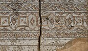
Though not usually a major tourist destination itself, Irbid is home to two notable museums: the Museum of Jordanian Heritage and the Jordan Natural History Museum, both on the campus of
-
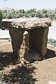 Irbid Museum Of Jordanian Heritage Dolmen
 -
 Irbid Museum Of Jordanian Heritage Decorated stone
 -
 Irbid Museum Of Jordanian Heritage Decorated stone
 -
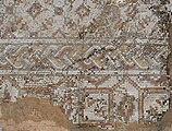 Irbid Museum Of Jordanian Heritage Mosaic
 -
 Irbid Museum Of Jordanian Heritage Mosaic
 -
 Irbid Museum Of Jordanian Heritage Mosaic
 -
 Irbid Museum Of Jordanian Heritage Mosaic
 -
 Irbid Museum Of Jordanian Heritage Mosaic
 -
 Irbid Museum Of Jordanian Heritage Mosaic
 -
 Irbid Centre
 -
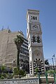 Irbid Clock tower


Geography
Irbid is situated in northern Jordan, on a fertile plateau. As of 2010, the city of Irbid encompassed an area of 30 km2, with residential areas making up 74.3% of the total area, followed by the Services areas occupying 9.5%, then Empty or unoccupied areas of 7.7%, then 4.2% is classified as Commercial areas, and 3.3% as Industrial areas, and finally gardens occupied 1% of the total city area.
Border cities
Climate
Irbid has a
| Climate data for Irbid (1985–2014) | |||||||||||||
|---|---|---|---|---|---|---|---|---|---|---|---|---|---|
| Month | Jan | Feb | Mar | Apr | May | Jun | Jul | Aug | Sep | Oct | Nov | Dec | Year |
| Mean daily maximum °C (°F) | 13.4 (56.1) |
14.3 (57.7) |
17.7 (63.9) |
22.8 (73.0) |
27.2 (81.0) |
30.0 (86.0) |
31.5 (88.7) |
31.8 (89.2) |
30.1 (86.2) |
26.7 (80.1) |
20.7 (69.3) |
15.5 (59.9) |
23.5 (74.3) |
| Daily mean °C (°F) | 9.35 (48.83) |
10.0 (50.0) |
12.85 (55.13) |
17.9 (64.2) |
21.05 (69.89) |
23.95 (75.11) |
25.8 (78.4) |
26.15 (79.07) |
24.55 (76.19) |
21.25 (70.25) |
15.6 (60.1) |
11.1 (52.0) |
18.30 (64.93) |
| Mean daily minimum °C (°F) | 5.3 (41.5) |
5.7 (42.3) |
8.0 (46.4) |
11.3 (52.3) |
14.9 (58.8) |
17.9 (64.2) |
20.1 (68.2) |
20.5 (68.9) |
19.0 (66.2) |
15.8 (60.4) |
10.5 (50.9) |
6.7 (44.1) |
13 (55) |
| Average precipitation mm (inches) | 101.5 (4.00) |
110.5 (4.35) |
69.6 (2.74) |
20 (0.8) |
6.4 (0.25) |
1.6 (0.06) |
0.0 (0.0) |
0.0 (0.0) |
0.7 (0.03) |
13.9 (0.55) |
58.4 (2.30) |
81.9 (3.22) |
464.5 (18.3) |
| Average precipitation days | 11.3 | 10.6 | 9.4 | 4.6 | 2.0 | 0.2 | 0.0 | 0.0 | 0.2 | 3.2 | 6.0 | 9.6 | 57.1 |
| Source: Jordan Meteorological Department[10] | |||||||||||||
Districts of Greater Irbid Municipality

Irbid is divided into 23 city districts forming smaller cities within the metropolitan sphere of influence of Irbid:
| District | District | District | |||
|---|---|---|---|---|---|
| 1 | Al'al | 9 | Foa'ra | 17 | Maru |
| 2 | Al Husn | 10 | Hakama | 18 | Mughayer |
| 3 | Al-Rabia | 11 | Hashemiyah | 19 | Naser |
| 4 | Al-Sareeh | 12 | Hawar | 20 | Rowdah |
| 5 | Barha | 13 | Huwwarah | 21 | Sal Area |
| 6 | Beit Ras | 14 | Kitim | 22 | Nu'aimah |
| 7 | Bushra (Jordan) | 15 | Kufr Jayez | 23 | Nuzha |
| 8 | Edun | 16 | Manarah ( hatim ) |


Cities, Towns, and Villages
Many villages surround the city of Irbid including:
- Birqish-Kufr Rakeb (برقش - كفر راكب)
- Irbid (اربد)
- Aṭ-Ṭaībah(الطيبة)
- Natfeh (ناطفه)
- Habaka (حبكا)
- Kufr-Rahta (كفررحتا)
- Al-Mazar Al-Shamali (المزار الشمالي)
- Hareema (حريما)
- Al'aal (علعال)
- Kufr Asad (كفرأسد)
- Kufr Aan (كفرعان)
- Jumha (جمحة)
- Kufryuba (كفر يوبا)
- Zahar (زحر)
- Qum (قمّ)
- Sammou' (سمّوع)
- Izmal (زمال)
- Kufrelma (كفر الماء)
- Sawm (سوم)
- Saydoor (صيدور)
- Kufr Soom (كفر سوم)
- Sama al-Rousan (سما الروسان)
- Ibser Abu Ali
- Assarieh (الصريح)
- Aidoon (ايدون)
- Al Husn (الحصن)
- Baleela (بليلة)
- Beit Ras (بيت راس)
- Dowgarah (دوقرة)
- En-Nu`aymeh (النعيمة)
- Habaka (حبكا)
- Houfa Al-Westiyyah
- Qumaim (قميم)
- Bushra (Jordan) (بشرى)
- Huwwarah (حوارة)
- Imrawah
- Al Ramtha (الرمثا)
- Sal (سال)
- Samad (صمد)
- Al Shajara (الشجرة)
- Al Turrah (الطرة)
- Fou'ara (فوعرة)
- Zoubia ( زوبيا)
- Jdaita (جديتا)
- Rehaba (رحابا)
- Kufor Alma (كفرالماء )
- Kharja (خرجا)
- Dair Yousef (دير يوسف)
- Dair Abos'eed (دير أبو سعيد)
- Kufor Kefia (كفر كفية)
- Summer (سمر)
- E'nbeh (عنبة)
- Bayt Yafa (بيت يافا)
- Dair Esse'neh (دير السعنة)
- Mandah (منده)
- Maru (Irbid) (مرو)
- Zabda (زبدة)
- Bait Idis (بيت ايدس)
- Makhraba (مخربا)
- Al-Murajjam
- Al Mughayer (المغير)
Hospitals

- Abu Obaida Hospital
- Al-Najah Hospital
- Al-Qawasmi Hospital
- Al-Ramtha Hospital
- Al-Yarmouk Hospital
- Ibn-Alnafees Hospital
- Irbid Islamic Hospital
- Irbid Speciality Hospital
- King Abdullah University Hospital
- Muaath Bin Jabal Hospital
- Princess Badeea Hospital
- Princess Basma Hospital
- Princess Rahma Hospital
- Princess Raya Hospital
- Rahbat Al-Wardieh Hospital
- Roman Catholic Hospital
Education
As of 2007, there were 70,000 registered students in Irbid's 10 universities, community colleges and institutes, of whom 8,000 were international students from 47 countries.[11] This high concentration of institutions of higher education has played a key role in carving a unique identity of the city. The largest universities in Irbid are:

.jpg)
- Yarmouk University[12]
- Jordan University of Science and Technology[13]
- Irbid National University[14]
- Al-Balqa` Applied University (Irbid campus)[15]
- Jadara University[16]
Private Schools in Irbid (sorted by alphabetical order):
- Adventist School
- Al-Arabiya Model School
- Al-Manara Schools [P]
- Al-Nahda Private School [P]
- Alwatany center
- American University School of the Middle East [17]
- Dar Al Uloum Schools [P]
- Greek Catholic School
- Irbid International Schools
- Irbid Model School [P]
- Islamic School [P] (Al-Madares Al-Islamiya)
- Jeel Al Jadeed School
- Jordan National Schools [P]
- Khawla Bint Alazwar [P]
- Rosary Sisters School
- Shoa'a Alammel School [P]
- Yarmouk University Model School [P]
- Al Sareeh Secondary School For girls [P]
Economy

Most of the city's economy is based on the services sector, that is directly or indirectly related to the higher education institutions in the city, as an example there are 26 book publishing companies in the city. The number of internet cafes per capita is the highest in the world that took Irbid to the
Sports
The Irbid-based club
Twin towns – sister cities
Irbid is twinned with:
Notable people
See also
Citations
- ^ "دائرة الإحصاءات العامة" (in Arabic).
- ^ http://dosweb.dos.gov.jo/DataBank/Population_Estimares/Municipalities.pdf [bare URL PDF]
- ^ http://dosweb.dos.gov.jo/DataBank/Population_Estimares/PopulationEstimatesbyLocality.pdf [bare URL PDF]
- ^ Irbid. Encyclopædia Britannica. Archived 21 April 2019 at the Wayback Machine.
- ^ [Lenzen, C. J.; Gordon, R. L.; and Mcquitty, A. M. 1985; Excavation at Tell Irbid and Beit Ras, 1985. ADAJ. Vol 29, pp. 151–159]
- ^ Haitham Mahmoud El-Hurani, Mohamed (1975). "Economic analysis of the development of the wheatsubsector of Jordan". Iowa State University Digital Repository. Retrieved 17 September 2020.
- ^ Hütteroth and Abdulfattah, 1977, p. 203
- ^ Robinson and Smith, 1841, vol 3, 2nd appendix, p. 163
- ^ Government of Jordan, Department of Statistics, 1964, p. 13
- ^ "Weather Information for Irbid". Jordan Meteorological. Retrieved 27 November 2016.
- ^ "تقرير اÙ"ØØ· اÙ"اساسي اÙ"اقتصادي Ù"اربد-2007". Archived from the original on 27 July 2011. Retrieved 1 May 2008.
- ^ Yarmouk University
- ^ "Jordan University of Science and Technology". Retrieved 24 November 2016.
- ^ Irbid National University
- ^ Balqa' Applied University
- ^ Al-Issa, Mohammad Omar. "Jadara University". Retrieved 24 November 2016.
- ^ "American University School Of The Middle East". sau.edu.jo. Retrieved 10 December 2019.
- ^ Gomes, Lee (18 November 2002). "College Town in Jordan Is Full of Internet Cafes". WSJ. Archived from the original on 11 January 2024.
- ^ Greater Irbid Municipality Archived 1 April 2009 at the Wayback Machine
- ^ "Kardeş Şehirlerimiz" (PDF). gaziantep.bel.tr (in Turkish). Gaziantep. 2013. p. 43. Archived from the original (PDF) on 6 February 2020. Retrieved 30 June 2020.
- ^ "友好城市". zhengzhou.gov.cn (in Chinese). Zhengzhou. Retrieved 30 June 2020.
General bibliography
- Government of Jordan, Department of Statistics (1964). First Census of Population and Housing. Volume I: Final Tables; General Characteristics of the Population (PDF).
- Hütteroth, Wolf-Dieter; Abdulfattah, Kamal (1977). Historical Geography of Palestine, Transjordan and Southern Syria in the Late 16th Century. Erlanger Geographische Arbeiten, Sonderband 5. Erlangen, Germany: Vorstand der Fränkischen Geographischen Gesellschaft. ISBN 3-920405-41-2.
- El-Khouri, Lamia, "Roman and Byzantine Settlements in the Region of West Irbid," Palestine Exploration Quarterly, 139,3 (2007), 166–185.
- Robinson, E.; Smith, E. (1841). Biblical Researches in Palestine, Mount Sinai and Arabia Petraea: A Journal of Travels in the year 1838. Vol. 3. Boston: Crocker & Brewster.
External links
- Irbid - Jordan Tourism Board Archived 15 April 2019 at the Wayback Machine
- Beautiful Natural Scenes From Al-Koura Department - Irbid
- Irbid News
- Greater Irbid Municipality
- Irbid Guide
- Irbid Discussion Forum (in Arabic)
- Al Husun FM Radio Station
- Photos of Irbid at the American Center of Research
| Capital | |
|---|---|
| Departments |
|
| Cities and towns |
|
| Others | |
| International | |
|---|---|
| National | |