
Irbid Governorate
Irbid Governorate
محافظة إربد | |
|---|---|
UTC+3 (GMT +3) | |
| • Summer (DST) | +3 |
| Area code | +(962)2 |
| Urban | 82.9% |
| Rural | 17.1% |
| HDI (2021) | 0.714[1] high · 6th of 12 |
Irbid or Irbed (
History
Iron Age
During the Iron Age, the region around Irbid, known then as Gilead, was settled by the Israelites.[2] Ar-Ramtha, the second largest city in the Irbid Governorate,[3] is commonly identified with the Israelite city of Ramoth-Gilead, a Levitical city and city of refuge east of the Jordan River, mentioned several times in the Hebrew Bible.[4][5]
By the late Iron Age, Gilead became the focus of a power struggle between the
In the 8th century BCE, the Assyrians gained control of the area, followed by the Babylonian and the Achaemenid Empire.
Classical antiquity
The region was later distinguished by the
plains. It was described as the most beautiful Syrian countries. Also it had the Islamic soldiers’ supplies. Christianity spread out there in the second and the third century CE.Middle Ages
With the conversion work of Islam, the Islamic opening armies achieved an advance. As a result,
During the
-
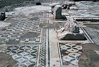
 The city ofUm Qais (Gadara)
 -
 AUm Qais
 -
 AAr Ramtha


Geography
Irbid Governorate is located in the far north west of Jordan in the
Demographics
.jpg)
The Jordan national census of 2004 demographic data indicate that Irbid Governorate had a population of 928,292. Estimates put the population slightly over one million for the year 2009. The next census was scheduled to be held in 2014.
| Demographics of Irbid Governorate (2004 Census)[8] | ||||||||||
|---|---|---|---|---|---|---|---|---|---|---|
| Female to Male ratio | 48.9% to 51.1% | |||||||||
| Jordanian citizens to foreign nationals | 96.6% to 3.4% | |||||||||
| Urban population | 707,420 | |||||||||
| Rural population | 220,872 | |||||||||
| Total population | 928,292 | |||||||||
The population of districts according to census results:[9]
| District | Population (Census 1994) |
Population (Census 2004) |
Population (Census 2015) |
|---|---|---|---|
| Irbid Governorate | 751,634 | 928,292 | 1,770,158 |
| Al-Āghwār ash-Shamāliyah | 78,355 | 85,203 | 122,330 |
| Al-Kūrah | 71,513 | 91,050 | 161,505 |
| Al-Mazār ash-Shamālī | 35,651 | 44,166 | 78,427 |
| Al-Wasṭīyah | ... | 24,046 | 42,571 |
Ar-Ramthā |
79,304 | 109,142 | 238,502 |
Aṭ-Ṭaībah |
23,847 | 29,132 | 51,501 |
| Banī Kenānah | 51,868 | 76,398 | 131,797 |
| Banī 'Obeīd | ... | 93,561 | 204,313 |
| Qaṣabah Irbid | ... | 375,594 | 739,212 |
Administrative divisions
Irbid Governorate is named after its capital and largest city. It is divided into nine departments called alweya which is the plural of liwaa. Many of these departments are within the sphere of influence (and constitute districts) of metropolitan Irbid
| Department | Arabic name | Population (2004) | Administrative center | |
|---|---|---|---|---|
| 1 | Al-Qasbah
|
لواء القصبة | 375,594 | Irbid |
| 2 | Bani Obaid Department | لواء بني عبيد | 93,561 | Al Hisn
|
| 3 | Al-Mazār ash-Shamālī Department | لواء المزار الشمالي | 44,166 | Al Mazar al Shamali |
| 4 | Ar Ramtha Department | لواء الرمثا | 109,142 | Ar Ramtha
|
| 5 | Bani Kinanah Department
|
لواء بني كنانة | 76,398 | Sama al-Rousan |
| 6 | Koura Department | لواء الكورة | 91,050 | Der Abi Saeed |
| 7 | Al-Aghwar Al Shamaliyyeh Department | لواء الأغوار الشمالية | 85,203 | North Shuna
|
| 8 | Taybeh Department
|
لواء الطيبة | 29,318 | Taybeh |
| 9 | Wasatieh Department | لواء الوسطية | 24,046 | Kufr Asad |
Cities, towns, and villages

- Ar RamthaThe second largest city in Irbid Governorate.
- Byzantineperiod is the most popular touristic destination in the Governorate.
- Many towns and villages surround the city of Irbid including:
Shatana (
Economy
There are three Qualified Industrial Zones (QIZ) in Irbid Governorate: Prince Hasan Industrial City, Cyber City, and Jordan River Crossing City. The net exports value of Prince Hasan Industrial City reached US$274 million in 2001 benefiting from its status as a Qualified Industrial Zone (QIZ). Clothing, chemicals and electronics constituted its main exports.[10] Irbid is at the top of the Jordanian agricultural regions especially in the production of
References
- ^ "Sub-national HDI - Area Database - Global Data Lab". hdi.globaldatalab.org. Retrieved 2018-09-13.
- OCLC 1101929531.)
{{cite book}}: CS1 maint: location missing publisher (link - ^ "Population of Jordan 2017" (PDF). Archived from the original (PDF) on 25 August 2018. Retrieved 1 November 2018.
- ^ Knauf, E. A., 2001: The Mists of Ramthalon, or, How Ramoth-Gilead disappeared from the Archaeological Record. BN 110, 33–36.
- ^ Lapp, P., 1968: Tell er-Rumeith. RB 75, 98–105.
- JSTOR 27931518.
- )
- ^ Jordan National Census of 2004 Table 3-1 Archived 2011-07-22 at the Wayback Machine
- ^ "Jordan: Administrative Division, Governorates and Districts". citypopulation.de. Retrieved 25 December 2016.
- ^ "Industry in Irbid (in Arabic)". Archived from the original on 2011-07-13. Retrieved 2010-07-08.
Places adjacent to Irbid Governorate | |
|---|---|
| North Region | ||
|---|---|---|
| Central Region | ||
| South Region | ||

| Capital | |
|---|---|
| Departments |
|
| Cities and towns |
|
| Others | |
| Authority control databases: Geographic |
|---|