
Isis Lock
| Isis Lock | |
|---|---|
 Isis Lock with the Oxford Canal on the left and the Castle Mill Stream on the right. | |
 | |
| 51°45′22″N 1°16′09″W / 51.75598°N 1.26924°W | |
| Waterway | Oxford Canal/Castle Mill Stream |
| County | Oxfordshire |
| First built | 1795–97 |
| Latest built | 1844 |
| Length | 77' |
Isis Lock (known to
lock connecting the Oxford Canal and the Castle Mill Stream, a backwater of the River Thames in Oxford, England.[1][2]
Location
The Isis Lock is close to
Oxford University
.
There is a winding hole for boats to turn on the Oxford Canal just to the north of the lock.
History
In central Oxford, the Oxford Canal and the River Thames were originally linked by a
David Harris replaced it with Isis Lock, a broad lock to allow Thames barges in and out of the Oxford Canal Company's Worcester Street wharves. Isis Lock was rebuilt as a narrow lock in 1844.[4]
Gallery
-
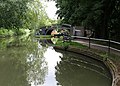
 The Oxford Canal, approaching Isis Lock with narrowboats moored by the canal.
 -
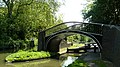
 View of Isis Lock and the footbridge.
 -
 Isis Lock, looking towards the river. The raised bricks facilitate the opening of the lock gate in wet weather.
 -
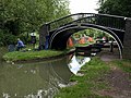
 Isis Lock Looking over the lock gate and under the bridge, towards the southern part of the Oxford Canal.
 -
 Isis Lock and the footbridge.
 -
 Looking over the lock gate.
 -
 Winding hole at Isis Lock.
 -
 Footbridge by Isis Lock.


References
- ^ "Isis Lock — Waterway Locks, Planes and Lifts on Waymarking.com". Waymarking.com. Retrieved 15 September 2012.
- ^ "Isis Lock — Oxford Canal (Oxford)". Wikimapia. Retrieved 15 September 2012.
- ^ "River Thames (Sheepwash Channel)". UK: CanalPlanAC. Retrieved 15 September 2012.
- ^ a b Davies & Robinson, 2003, page 43.
Sources
- Davies, Mark; Robinson, Catherine (2003) [2001]. A Towpath Walk in Oxford. Oxford: Oxford Towpath Press. ISBN 0-9535593-1-9.