
Isla de Cabras
 Isla de Cabras from El Morro | |
 Isla de Cabras  Isla de Cabras  Isla de Cabras | |
| Geography | |
|---|---|
| Location | San Juan bay, Puerto Rico |
| Coordinates | 18°28′20.51″N 66°8′12.3″W / 18.4723639°N 66.136750°W |
| Administration | |
| Commonwealth | Puerto Rico |
| Municipality | Toa Baja |
| Barrio | Palo Seco |
Isla de Cabras (Spanish for goat island) is an islet located at the entrance of the San Juan Bay in Puerto Rico. It is part of the Palo Seco barrio of the municipality of Toa Baja.
Isla de Cabras is the current location of:[citation needed]
- Fortín San Juan de la Cruz, also known as El Cañuelo.[1]
- A recently opened recreational park.
- A local police firing range.
Island has been a place of many uses during its history.
History
Spanish Fortification
Due to its strategic location at the entrance of
Leper Colony

At the end of the 19th century, a
Upon the occupation of
In 1926, a leper asylum was built on the main island (Trujillo Alto) next to a church, and the residents of the colony were moved there. However, the original building still stands on Isla de Cabras.
American Fortification
In the 1940s, the
Shooting Range & Recreational Park
In recent years, the grounds that belonged to Fort Amezquita were converted into a shooting range and training area by the
Gallery
Places and views of Isla de Cabras:
-
 Isla de Cabras with El Morro in the background
 -

-

-
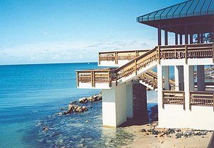 One of the main gazebos at Isla de Cabras Recreational Park (2005)
 -
 Isla de Cabras
 -
 Aerial view of Isla de Cabras


See also
- El Cañuelo
References
- ^ "El Cañuelo". Atlas Obscura.
- ^ "Parque Nacional Isla de Cabras". Discover Puerto Rico. Retrieved May 27, 2022.
External links
- The Bio-political History of Isla de Cabras Leper Colony and the Problematics of the Memorialization of Suffering by Adriana María Garriga López, Columbia University