
Islamabad Capital Territory
Islamabad Capital Territory
وفاقی دارالحکومت | ||
|---|---|---|
Union Councils 50[citation needed] | | |
| Website | www.ictadministration.gov.pk/ | |
The Islamabad Capital Territory (ICT;
History
In 1960, land was transferred from
- Rawalpindi, 259 square kilometres (100 sq mi)
- Islamabad Urban, 220.15 square kilometres (85.00 sq mi)
- Margalla Hills, 220.15 square kilometres (85.00 sq mi)
- Islamabad Rural, 466.20 square kilometres (180.00 sq mi)[4]
However, Rawalpindi was eventually excluded from the Islamabad master plan in the 1980s.[8]
Administration

Zones

Islamabad is subdivided into five zones:[9][10]
- Zone I: Designated for urban development and federal government institutions
- Zone II: Designated for urban development
- Zone III: Designated for rural development
- Zone IV: Designated for rural development
- Zone V: Designated for rural development
Sectors
Union councils

Islamabad Capital Territory comprises urban and rural areas. The rural consists of 23 union councils, comprising 133 villages, while urban has 27 union councils.[11]
| UC # | Chief locality | Localities within jurisdiction |
|---|---|---|
| 1 | Saidpur | Said Pur, Gokina, Talhar |
| 2 | Noorpur Shahan | Noorpur Shahan, Ratta Hutar |
| 3 | Mal Pur | Mal Pur, Romali, Nariyas, Phadu, Shahdrah Khurd, Shahdrah Kalan, Mandala, Jang Begial, Subban Syedan, Mangial, Quaid-e-Azam University |
| 4 | Kot Hathial (Shamal) | Kot Hathial, Bhara Kahu, Nayiabadi, Muhallah Alnoor, Muhallah Ban, Muhallah Malkan, Dhok Syedan |
| 5 | Kot Hathial (Janoob) | Kot Hathial, Nainsukh, Barakahu, Behra Syedan, Muhallah Ghousia, Sharak-e-Madina, Dhok Jilani, Muhallah Malikabad |
| 6 | Phulgran | Phulgran, Phul Garan, Dhok Kuch, Abbasiabad, Dhok Badhan, Muhallah Kangar, Mahallah Ranjpuran, Shahpur, Bobry, Karlot Chattar, Mohra Rajpoota, Muhallah Sumbul, Bani Gala |
| 7 | Pind Begwal | Pind Begwal, Bainala, Maira Biguwal, Atthal, Dhok Sajjal, Dhok Nanda Sihali, Jandala, Simli |
| 8 | Tumair | Tumair, Pihont, Chakhtan, Darkalam, Kanjnah |
| 9 | Charah | Charah, Dhok Maira, Dhok Las, Kiani, Dhok Haveli |
| 10 | Kirpa | Kirpa, Ladhiot Syedan, Pind Malikan, Dhok Ban, Bhimbar Tarar, Mahallah Haveli Rajgan, Mehfozabad, Chaniol, Muhallah Chaudrian, Ara, Gora Mast, Dhok Jogian Harnu, Chauntra Sogran |
| 11 | Mughal | Mughal, Hardoghar, Kangota Gujjran Sihala, Hondamial, Nara Syedan, Chuchkal Chakiyan, Chak Kamdar |
| 12 | Rawat | Rawat, Bhangrial Kalan, Banni Saran, Mohra Nagial, Sawan, Bagga Shaikhan |
| 13 | Humak
|
Humak, Kaniyal, Gora Syedan, Niazian |
| 14 | Sihala | Sihala Khurd, Maira Dakhli, Bhandar Sihala, Jarki Sihala, Gagri Sihala, Jhundla, Kangota Syedan, Gura Mistriyan |
| 15 | Lohi Bhair | Lohi Bhar, Shahrak-e-Korang, Bagh-e-Sawan, Shahrak-e-Pakistan |
| 16 | Darwala | Darwala, Dhaliala, Panwal, Chucha Sheikhiyan, Bhair, Kanghar, Sher Ghamial, Dhok Kavgar, Kathrial, Chucha, Dhok Kashimiriya, Harn maira, Malali, Bun koutha, Pahg Panwal, Farash, Bangiyal |
| 17 | Koral
|
Koral , Tarlai Khurd, Gangal, Chaklala, Shareefabad, Gohra Sardar, Tarlai
|
| 18 | Khana Dak | Khana Dak, Dhok Jabba, Pindorian, Shahrak-e-Bilal, Shahrak-e-Barma, Shahrak-e-Madina, Muhallah Wahid Abad, Shahrak-e-Masih) |
| 19 | Tarlai Kalan
|
Tarlai Kalan, Irfanabad, Chappar Meer Khanal, Sahana |
| 20 | Ali Pur
|
Ali Pur , Alipur,Jhang Syedan,Partal, Khadrapar, Farash,
|
| 21 | Sohan | Sohan Dehati, Khana Kak, Shakrial, Shakrial (Sharki) |
| 22 | Chak Shahzad | Chak Shahzad, Chak Bihra Shigh, Jaba Teli, Sohana, Pandori, Chhatta Bakhtawar, Bohan, Dhoke Sharaf, Mujuhan |
| 23 | Kuri | Kuri, Malot, Rakh Bani Gala, Rihara, Mohra Jujan |
| 24 | Shahrak-e-Rawal | Shahrak-e-Rawal, Shahrak-e-Margala, Sumbal Korakh, Puna Faqeeran, Mohrian |
| 25 | Sector F-6 | F-6/1, F-6/2, F-6/3, F-6/4, Farooqi Bazar, Madni Masjid, Dhobi Gat |
| 26 | Sector G-6/1 | |
| 27 | Sector G-6 | Sector G-6/2, Sector G-6/3 & Sector G-6/4 |
| 28 | Sector F-7, F-8, F-9 | |
| 29 | Sector F-10, F-11 | |
| 30 | Sector G-7/3, G-7/4 | |
| 31 | Sector G-7/1, G-7/2 | |
| 32 | Sector G-8/3, G-8/4 | |
| 33 | Sector G-8/1, G-8/2 | |
| 34 | Sector G-9 | Sector G-9/1, G-9/3, G-9/4 |
| 35 | Sector G-9/2 | |
| 36 | Sector G-10/3, G-10/4 | |
| 37 | Sector G-10/1, G-10/2 | |
| 38 | Sector G-11 | Sector G-11/1, G-11/2, G-11/3, G-11/4 |
| 39 | Maira Sumbal Jaffar | Maira Sumbal Jaffar, Golra Sharif, Badia Rusmat Khan, Maira Akku, Dhareek Mohri, Shahrak-e-Effaq |
| 40 | G-13
| |
| 40 | Sector I-8 | Sector I-8/1,I8/2,I8/3,I8/4 |
| 41 | Sector I-9 | |
| 42 | Sector I-10/1 | |
| 43 | Sector I-10 | Sector I-10/2, I-10/3, I-10/4 |
| 44 | Bokra | Bokra, Haji Complex, Soria Harboza, Mouza Sorain, Peer Wadhai, Shahrak-e-Iqbal |
| 45 | Jhangi Saydan | |
| 46 | Village Noon | Badhana Kalan, Dhoke Makhan, ETC |
| 47 | Tarnol | |
| 48 | Sarai Kharbooza | |
| 49 | Shah Allah Ditta | |
| 50 | Golra Sharif |
Climate

Seasons
The climate of Islamabad has a humid subtropical climate (Köppen: Cwa), with five seasons: winter (November–February), spring (March and April), summer (May and June), rainy monsoon (July and August), and autumn (September and October).
Temperatures
The temperatures range from 13 °C (55 °F) in January to 38 °C (100 °F) in June. The hottest month is June, where average highs routinely exceed 38 °C (100.4 °F), while the coolest month is January. The highest recorded temperature was 46.6 °C (115.9 °F) on 23 June 2005 while the lowest temperature was −6 °C (21.2 °F) on 17 January 1967.[12][13] Winters generally feature dense fog in the mornings and sunny afternoons. In the city, temperatures stay mild, with snowfall over the higher elevations points on nearby hill stations, notably Murree and Nathia Gali.
Precipitation
The wettest month is July, with heavy rainfalls and evening
Vegetation
Around 220 acres (89 ha) of the city consists of the
| Climate data for Islamabad (1991-2020) | |||||||||||||
|---|---|---|---|---|---|---|---|---|---|---|---|---|---|
| Month | Jan | Feb | Mar | Apr | May | Jun | Jul | Aug | Sep | Oct | Nov | Dec | Year |
| Record high °C (°F) | 30.1 (86.2) |
30.0 (86.0) |
37.0 (98.6) |
44.0 (111.2) |
45.6 (114.1) |
50.0 (122.0) |
45.0 (113.0) |
42.0 (107.6) |
38.1 (100.6) |
38.0 (100.4) |
32.2 (90.0) |
28.3 (82.9) |
50.0 (122.0) |
| Mean daily maximum °C (°F) | 17.7 (63.9) |
20.0 (68.0) |
24.8 (76.6) |
30.6 (87.1) |
36.1 (97.0) |
38.3 (100.9) |
35.4 (95.7) |
33.9 (93.0) |
33.4 (92.1) |
30.9 (87.6) |
25.4 (77.7) |
20.4 (68.7) |
28.9 (84.0) |
| Daily mean °C (°F) | 10.7 (51.3) |
13.4 (56.1) |
18.1 (64.6) |
23.6 (74.5) |
28.7 (83.7) |
31.4 (88.5) |
30.1 (86.2) |
29.1 (84.4) |
27.6 (81.7) |
23.3 (73.9) |
17.3 (63.1) |
12.5 (54.5) |
22.2 (71.9) |
| Mean daily minimum °C (°F) | 3.6 (38.5) |
6.8 (44.2) |
11.4 (52.5) |
16.6 (61.9) |
21.5 (70.7) |
24.5 (76.1) |
24.9 (76.8) |
24.2 (75.6) |
21.7 (71.1) |
15.6 (60.1) |
9.1 (48.4) |
4.7 (40.5) |
15.4 (59.7) |
| Record low °C (°F) | −6 (21) |
−5.0 (23.0) |
−3.8 (25.2) |
2.1 (35.8) |
5.5 (41.9) |
13 (55) |
15.2 (59.4) |
14.5 (58.1) |
13.3 (55.9) |
5.7 (42.3) |
−0.6 (30.9) |
−2.8 (27.0) |
−6.0 (21.2) |
| Average precipitation mm (inches) | 55.2 (2.17) |
99.5 (3.92) |
96.5 (3.80) |
58.1 (2.29) |
39.9 (1.57) |
78.4 (3.09) |
310.6 (12.23) |
317.0 (12.48) |
135.4 (5.33) |
34.4 (1.35) |
17.7 (0.70) |
25.9 (1.02) |
1,268.6 (49.95) |
| Average precipitation days (≥ 1.0 mm) | 4.7 | 8.0 | 7.3 | 6.1 | 5.2 | 6.0 | 12.3 | 11.9 | 6.4 | 2.9 | 2.0 | 2.0 | 74.8 |
| Mean monthly sunshine hours | 195.7 | 187.1 | 202.3 | 252.4 | 319.0 | 300.1 | 264.4 | 250.7 | 262.2 | 275.5 | 247.9 | 195.6 | 2,952.9 |
| Source 1: NOAA (sun, 1961-1990)[18][19] | |||||||||||||
| Source 2: PMD (extremes)[20] | |||||||||||||
Cityscape
Civic administration
The main administrative authority of the city is Islamabad Capital Territory Administration with some help from Metropolitan Corporation Islamabad and Capital Development Authority (CDA), which oversees the planning, development, construction, and administration of the city. Islamabad Capital Territory is divided into eight zones: Administrative Zone, Commercial District, Educational Sector, Industrial Sector, Diplomatic Enclave, Residential Areas, Rural Areas and Green Area.
Islamabad city is divided into five major zones: Zone I, Zone II, Zone III, Zone IV, and Zone V. Out of these, Zone IV is the largest in area. All sectors of Ghouri Town (1, 2, 3, VIP, 5, 4-A, 4-B, 4-C, 5-A, 5-B and sector 7) are located in this zone. Zone I consists mainly of all the developed residential sectors, while Zone II consists of the under-developed residential sectors. Each residential sector is identified by a letter of the alphabet and a number, and covers an area of approximately 4 square kilometres. The sectors are lettered from A to I, and each sector is divided into four numbered sub-sectors.[21]
Sectors
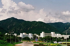
Series A, B, and C are still underdeveloped. The D series has seven sectors (D-11 to D-17), of which only sector D-12 is completely developed. This series is located at the foot of Margalla Hills.
The H sectors are numbered H-8 through H-17. The H sectors are mostly dedicated to educational and health institutions.
Demographics
Language
While urban Islamabad is home to people from all over Pakistan as well as expatriates, in the rural areas a number of Pothohari speaking tribal communities can still be recognised.[27]
Religion
Religion in Islamabad Territory, Pakistan[29]
Islamabad-Rawalpindi metropolitan area
When the master plan for Islamabad was drawn up in 1960, Islamabad and Rawalpindi, along with the adjoining areas, was to be integrated to form a large metropolitan area called Islamabad/Rawalpindi Metropolitan Area. The area would consist of the developing Islamabad, the old colonial cantonment city of Rawalpindi, and Margalla Hills National Park, including surrounding rural areas.[30][31] However, Islamabad city is part of the Islamabad Capital Territory, while Rawalpindi is part of Rawalpindi District, which is part of province of Punjab.[32]
Initially, it was proposed that the three areas would be connected by four major highways: Murree Highway,
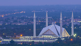
-
 Chaghi Monument
 -
 Pakistan Secretariat
 -
 Star and Crescent Monument near the start of Shakarparian
 -
-
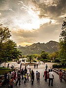 Daman-e-Koh Park
 -
 Sunset over the Lake View Park
 -
 view of Blue Area, the commercial hub of the city.


Economy


Islamabad is a net contributor to the Pakistani economy, as whilst having only 0.8% of the country's population, it contributes 1% to the country's GDP.
Islamabad has seen an expansion in
Tourism
Transport
Airport
Islamabad is connected to major destinations around the world through the Islamabad International Airport. The airport is the largest in Pakistan, handling 9 million passengers per annum. The airport was built at a cost of $400 million and opened on 3 May 2018, replacing the former Benazir Bhutto International Airport. It is the first greenfield airport in Pakistan with an area of 3,600-acre (15 km2).[40]
Metrobus
The Rawalpindi-Islamabad Metrobus is a 24 km (14.9 mi) bus rapid transit system that serves the twin cities of Rawalpindi and Islamabad in Pakistan. It uses dedicated bus lanes for all of its route covering 24 bus stations. Islamabad is well connected with other parts of the country through car rental services such as Alvi Transport Network and Pakistan Car Rentals.[citation needed]
Motorways
All major cities and towns are accessible through regular trains and bus services running mostly from the neighbouring city of Rawalpindi. Lahore and Peshawar are linked to Islamabad through a network of motorways, which has significantly reduced travelling times between these cities. M-2 Motorway is 367 km (228 mi) long and connect Islamabad and Lahore.[41] M-1 Motorway connects Islamabad with Peshawar and is 155 km (96 mi) long.[41] Islamabad is linked to Rawalpindi through the Faizabad Interchange, which has a daily traffic volume of about 48,000 vehicles.[42]
Education
Islamabad has the highest literacy rate of Pakistan at 95%.
Private School Network Islamabad is working for private educational institutions. The president of PSN is Dr. Muhammad Afzal Babur from Bhara Kahu. PSN is divided into eight zones in Islamabad. In Tarlai Zone Chaudhary Faisal Ali from Faisal Academy Tarlai Kalan is Zonal General Sectary of PSN.
- Bahria University
- Air University
- Quaid-e-Azam University
- Allama Iqbal Open University (AIOU)
- Alkauthar Islamic University
- COMSATS Institute of Information Technology(CIIT)
- Capital University of Science and Technology (CUST) [Formally Mohammad Ali Jinnah University, Islamabad Campus]
- Federal Urdu University of Arts, Science & Technology(FUUAST)
- National University of Sciences and Technology(NUST)
- National Defense University, Islamabad(NDU)
- National University of Modern Languages (NUML)
- Institute of Space Technology
- International Islamic University Islamabad
- Institute of Cost and Management Accountants of Pakistan (ICMAP)
- Institute of Chartered Accountants of Pakistan (ICAP)
- Pakistan Institute of Development Economics (PIDE)
- Pakistan Institute of Engineering and Applied Sciences (PIEAS)
- Shifa College of Medicine
- Foundation University Islamabad (FUI)
- National University of Computer & Emerging Sciences(FAST-NUCES)
- Riphah International University
- University of Lahore
- Center for Advanced Studies in Engineering
- Preston University Islamabad Campus
- Iqra University Islamabad Campus
- Shaheed Zulfiqar Ali Bhutto Institute of Science and Technology(ZABIST)
- Hamdard University Islamabad Campus
Sports
See also
- Islamabad Capital Territory Administration
- List of cultural heritage sites in Islamabad Capital Territory
- Developments in Islamabad
- Model Town Humak
References
- ISBN 9781107008151.
- ^ "Major shuffle in top bureaucracy on ECP direction". Dawn (newspaper). 19 August 2023. Retrieved 20 August 2023.
- ^ "Board Members - CDA". Capital Development Authority. Retrieved 15 March 2022.
- ^ a b "CDA Facts & Figures". Retrieved 24 November 2023.
- ^ a b "Announcement of Results of 7th Population and Housing Census-2023" (PDF). Pakistan Bureau of Statistics (www.pbs.gov.pk). 5 August 2023. Retrieved 24 November 2023.
- ^ "Sub-national HDI - Area Database - Global Data Lab". hdi.globaldatalab.org. Retrieved 18 August 2021.
- ^ "Facts & Statistics - Islamabad".
- ^ ISBN 978-0-415-52597-8.
- ^ "Federal Territory". HIKEPK. Retrieved 3 February 2019.
- ^ "Capital Development Authority". www.cda.gov.pk. Retrieved 12 July 2022.
- ^ Islamabad Capital Territory Administration Archived 4 April 2011 at the Wayback Machine. Ictadministration.gov.pk. Retrieved on 12 July 2013.
- ^ "Best Housing Societies in Islamabad to Invest in 2022". 13 June 2010. Archived from the original on 13 June 2010. Retrieved 15 January 2012.
- ^ "Average Conditions, Islamabad, Pakistan". Retrieved 25 September 2009.
- ^ "Climate Records: Islamabad". Archived from the original on 12 January 2012. Retrieved 14 January 2012.
- ^ "Severe Storms on dated 23rd July 2001 Islamabad, Pakistan" (PDF). Abdul Hameed, Director Pakistan Meteorological Department.
- ^ "Weather Log – July 21–31, 2001". National Climatic Data Center. 6 August 2001.
- ^ "Urban growth monitoring along Islamabad Highway". GIS Development.
- ^ "Islamabad Climate Normals 1961-1990". National Oceanic and Atmospheric Administration. Retrieved 16 January 2012.
- ^ "Islamabad Climate Normals 1991–2020". World Meteorological Organization Climatological Standard Normals (1991–2020). National Oceanic and Atmospheric Administration. Retrieved 17 September 2023.
- ^ "Extremes of Islamabad". Pakistan Meteorological Department. Retrieved 1 February 2015.
- ISBN 978-0520272156. Retrieved 4 July 2012.
- ^ a b c d e f "The Idea of Islamabad". TheIslamabad.com. Archived from the original on 10 September 2009. Retrieved 10 October 2015.
- ^ Bahria University. "Official website". Archived from the original on 1 March 2010.
- ^ Air University. "Official website".
- ^ National Defence University. "Official website".
- ^ "CCI defers approval of census results until elections". Retrieved 2 April 2020.
- ^ A Gazetteer of Rawalpindi District Part A 1907
- ^ "Wayback Machine: Population of Pakistan by Religion" (PDF). Wayback Machine (PDF). Retrieved 21 March 2024.
{{cite web}}: Check|archive-url=value (help) - ^ "Population by Religion" (PDF). pbs.gov.pk. Pakistan Bureau of Statistics.
- ^ ISBN 978-9048199198. Retrieved 4 July 2012.
- ^ a b Muhammad. "Planning of Islamabad and Rawalpindi" (PDF).
- ^ Sheikh, Iqbal M.; Van S. Williams; S. Qamer Raza; Kanwar S.A. Khan. "Environmental Geology of the Islamabad-Rawalpindi Area, Northern Pakistan" (PDF). Regional Studies of the Potwar Plateau Area, Northern Pakistan. U.S. Department of the Interior, U.S. Geological Survey.
- ^ "Margalla Avenue to benefit commuters of KPK, traffic on Kashmir Highway". OnePakistan. Archived from the original on 4 March 2016. Retrieved 7 October 2013.
- ^ "Pakistan | Economics and extremism". Dawn. 5 January 2010. Archived from the original on 8 January 2010. Retrieved 2 June 2010.
- ^ "Pakistan Stock Exchanges". Archived from the original on 28 February 2010. Retrieved 10 October 2015.
- ^ ISE-Official website. "About ISE". Archived from the original on 17 June 2011.
- ^ "Rs 371bn revenue target: FBR hails LTU Islamabad's performance". Business Recorder. 5 July 2012. Retrieved 9 July 2012.
- ^ Pakistan Software Export Board. "Islamabad". Archived from the original on 5 May 2010.
- ^ "Retail Prices of Vegetables, Fruits and Poultry in Islamabad from 2015-2020". Deliver It - Online Grocery Store in Islamabad. Archived from the original on 14 April 2020. Retrieved 7 September 2020.
- ^ CPG Corporation. "New Islamabad International Airport's Passenger Terminal Building". Archived from the original on 21 November 2007.
- ^ a b National Highway Authority Pakistan. "Motorway's of Pakistan".
- ^ NESPAK. "Faizabad Interchange". Archived from the original on 10 August 2011.
- ^ "LITERACY-POPULATION 10 YEARS AND OLDER" (PDF). Archived from the original (PDF) on 13 November 2010. Retrieved 28 September 2010.
- ^ HEC recognized Universities Archived 29 October 2013 at the Wayback Machine. Hec.gov.pk. Retrieved on 12 July 2013.
- ^ "ARY Digital Network President Salman Iqbal congratulates Islamabad United over winning PSL". arynews.tv. 24 February 2016. Retrieved 24 February 2016.
External links
 Definitions from Wiktionary
 Media from Commons
 News from Wikinews
 Quotations from Wikiquote
 Texts from Wikisource
 Textbooks from Wikibooks
 Resources from Wikiversity
 Travel information from Wikivoyage
![]() Islamabad travel guide from Wikivoyage
Islamabad travel guide from Wikivoyage

| Provinces | ||
|---|---|---|
| Territories | ||
| Administrative regions | ||
See also: Former administrative units of Pakistan | ||
| International | |
|---|---|
| National | |
| Geographic | |