
Island No. 2
 Panoramic photo of Island No. 2 in March 2023 | |
 Island No. 2  Island No. 2  Island No. 2 | |
| Geography | |
|---|---|
| Location | Northern California |
| Coordinates | 38°09′46″N 122°19′56″W / 38.16278°N 122.33222°W[1] |
| Adjacent to | Napa River |
| Highest elevation | 3 ft (0.9 m)[1] |
| Administration | |
United States | |
| State | |
| County | Solano |
Island No. 2 is a mostly-submerged island in Solano County, California. Formerly swampland, it was reclaimed into productive farmland, and became the subject of lengthy legal disputes in the early 20th century. Since then, it has become again submerged, and is now part of the Napa-Sonoma Marshes Wildlife Area.
Geography
Island No. 2's coordinates are 38°09′46″N 122°19′56″W / 38.16278°N 122.33222°W[1], and the United States Geological Survey measured its elevation as 3 ft (1 m) in 1981.[1] As part of the Napa-Sonoma Marshes Wildlife Area (in which it is designated "Napa River Unit Pond 2"),[2]: 156 the area is "regularly used by hunters, fishermen, bird watchers, photographers, and hikers".[3]
It is bounded on the north and east by
-
 Island No. 2 as it appears on a 1902 USGS map.
 -
 Island No. 2 as it appears on a 1951 USGS map.
 -
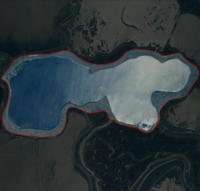 USGS aerial imagery in 2021


History
Many of the islands at the mouth of the Napa River were first discovered by Europeans in an 1823 Spanish expedition led by Francisco Castro.
Reclamation
This land was reclaimed, and the swamps drained, at some point in the mid-to-late-1800s; Island No. 2 was contained within Survey No. 115.[2]: 154 By the end of the 19th century, "most marshland in the [area] was diked, drained, and being used for livestock grazing and farmland".[2]: 154 Island No. 2, along with Island No. 1, Green Island and Tubbs Island, are labeled on a 1902 USGS map of the area.[8]
In the early 1900s, Island No. 2 (like the neighboring Island No. 1, also known as "Cross Island") was owned by L.E. Cross.[9] Later, it came into the possession of David T. Hanbury, an "English scion" and millionaire who owned several breweries and wineries in England and California.[10] Hanbury farmed the land, and had "men over on the Island".[10]
On October 21, 1908, the island was deeded to David's wife Marie Eleanor Hanbury, a "former
Later, on the morning of January 19, 1909, the Napa County Recorder's office recorded a deed in which David Hanbury sold Island No. 2 to his brother John McKenzie Hanbury, of London, for a sum of $10 ($339.00 in 2023).[11] This deed had been executed in San Francisco on January 8, 1908; it was, however, entered into the county record nearly a month after the transfer of the island to Marie.[11] Around February 1909, David fractured a rib while "endeavoring to get into a bath tub at Island No. 2".[12]
David claimed that the deed transferring the island to his brother "was either obtained from him under the influence of drugs or was a forgery", saying that "it is at least odd that, if it was made more than a year ago, it was not recorded until after the genuine deed to the property which I made to my wife".[13] In February, he and Marie Eleanor left for England; the Napa Journal said that "while it was reported that the trip was made for the benefit of the husband's health, it was believed that the real purpose was to reach an amicable understanding with the brother in Old England".[13] David engaged an attorney, Hiram Johnson, to "establish the validity of [his] wife's deed to the property".[13] On December 4, John's claims to the island were dismissed.[14]
By 1910, divorce proceedings between David T. Hanbury and Marie Eleanor were underway; the Napa Weekly Journal said that during these proceedings "the title to the famous island passed rapidly from Hanbury to his wife, then to his brother John, the English brewer, and again to the Napa Bank, and all around the circle again". By May, they had "[settled] their marital troubles" and gone to live in Santa Cruz.[15] On May 22, 1910, Marie Eleanor gave birth to a son, David Mackenzie Hanbury.[15][14]
David T. Hanbury died in October 1910, at the White Sulphur Springs in
By 1920, the island was again in legal dispute; David Mackenzie was at that point half owner of the island (held in trust by the Anglo-California Trust Company). William Banta, David Mackenzie's uncle and legal guardian, was sued by the British members of the family for ownership of Island No. 2 and other properties in the estate.[20] The island was put up for public auction in June 1925.[9] In November 1926, some interest in the property was sold from Ellen Weinstein, Estelle Meyer and others to a Z.S. Israelsky.[21] In December 1927, another notice of guardian's sale was issued, again for Island No. 2 being sold by its owner David Mackenzie Hanbury.[22] In February 1928, a transaction was recorded in which the Anglo-California Trust Company sold Island No. 2 to a Nat Boas; on the same day, Nat Boas also acquired Z.S. Israelsky's interest in said property.[23]
In 1927, construction started on a bascule bridge connecting to Island No. 2 from Vallejo; a cofferdam was placed in April,[24] and construction was "nearly finished" by September.[25]
By 1928, there existed a Hanbury Island Gun Club on the island, at which were located a "handsome new club house with 8 bedrooms, a huge club room, kitchen, pantry, showers, lavatories and all other modern conveniences" in addition to "a keeper's cottage, outhouses, blinds, ponds, levees, etc".[26]

While Island No. 2 had been shown as dry land surrounded by levees in 1916 USGS maps,[27] by 1942 it is shown as having significant amounts of marsh and water in its interior.[28] By 1949, its interior is shown as almost entirely marshlands, although the "Lachman Club" remains on its northwest side.[29] This remains the case in 1951,[5] but by 2012 no club is shown, and the island is shown as completely submerged.[30]
In 1994, large tracts of land (including many islands and former islands in the area) were purchased from Cargill by state agencies.
References
- ^ a b c d U.S. Geological Survey Geographic Names Information System: Island No. 2
- ^ a b c d e f g URS Corporation (October 2011). "Napa-Sonoma Marshes Wildlife Area Land Management Plan". California Department of Fish and Game. Retrieved February 26, 2021.
- ^ "Area History". California Department of Fish and Wildlife. November 1, 2021.
- ^ a b c Topography, State of California: Cuttings Wharf Quadrangle, United States Geological Survey, 2021
- ^ a b Topography, State of California: Cuttings Wharf Quadrangle, United States Geological Survey, 1951
- ^ Ringgold, Cadwalader; blunt, Simon F.; Stuart, Fred D.; Campbell, A. H. (1852). Chart of the Bay of San Pablo Straits Of Carquines and part of the Bay of San Francisco California (Map). Jno. T. Towers.
- ^ Hoffmann, Charles F.; Whitney, J. D. (1867). North Sheet: Map Of The Region Adjacent To The Bay Of San Francisco (Map). 1:126720. Geological Survey of California.
- ^ Topography, State of California: Mare Island Quadrangle, United States Geological Survey, 1902
- ^ a b "Notice of Guardian's Sale of Real Property at Private Estate". The St. Helena Star. St. Helena, California. May 15, 1925. p. 7. Retrieved November 18, 2021 – via Newspapers.com.
- ^ a b c d e f "She Needs Money: Mrs. Marie E. Hanbury Mortgages Island No. 2 to Bank of Napa". Napa Weekly Journal. Napa, California. January 1, 1909. p. 1.
- ^ a b "Another Deed: Mrs. Hanbury's Big Christmas Present Was Sold a Year Ago". Napa Weekly Journal. Napa, California. January 22, 1909. p. 1.
- ^ "Hanbury Breaks Ribs". Napa Journal. Napa, California. January 8, 1910. p. 6.
- ^ a b c "Bank of Napa Assigns Mortgage On Island No. 2 to Hanbury's Brother, Who Also Holds Deed". Napa Journal. Napa, California. May 28, 1909. p. 8.
- ^ a b c "Hanbury Dies". Napa Weekly Journal. Napa, California. October 28, 1910. p. 6.
- ^ a b "Telegraphic News, Santa Cruz". Napa Weekly Journal. Napa, California. May 27, 1910. p. 2.
- ^ "Hanbury Estate". Napa Weekly Journal. Napa, California. February 24, 1911. p. 12.
- ^ "Fifty years ago". The Napa Valley Register. Napa, California. February 24, 1964. p. 4. Retrieved November 18, 2021 – via Newspapers.com.
- ^ "NOTICE OF SALE OF REAL ESTATE". The Recorder. San Francisco, California. December 3, 1915. p. 7. Retrieved January 20, 2024 – via Newspapers.com.
- ^ "Quarreled Over Lease". Napa Journal. Napa, California. August 4, 1916. p. 4.
- ^ "Fight in Hanbury Estate Again On". Napa Journal. Napa, California. February 1, 1920. p. 1. Retrieved November 18, 2021 – via Newspapers.com.
- ^ "Real Estate Transfers". Napa Journal. Napa, California. November 25, 1926. p. 6. Retrieved November 18, 2021 – via Newspapers.com.
- ^ "Notice of Guardian's Sale of Real Estate at Private Sale". The St. Helena Star. St. Helena, California. January 6, 1928. p. 5. Retrieved November 18, 2021 – via Newspapers.com.
- ^ "Real Estate Transfers". Napa Journal. Napa, California. February 22, 1928. p. 3. Retrieved November 18, 2021 – via Newspapers.com.
- ^ "Napa River Coffer Dam Building Starts". The Napa Valley Register. Napa, California. April 20, 1927. p. 6. Retrieved November 18, 2021 – via Newspapers.com.
- ^ "Bascule Lift Is Completed Across River". The Napa Valley Register. Napa, California. September 6, 1927. p. 5. Retrieved November 18, 2021 – via Newspapers.com.
- ^ "Improvements at Island Gun Club". The Napa Valley Register. Napa, California. August 25, 1928. p. 4. Retrieved November 18, 2021 – via Newspapers.com.
- ^ Marshall, R.B.; Davis, Geo. R.; Leavitt, J.B. (1916), Topography, State of California: Mare Island Quadrangle, United States Geological Survey
- ^ Topography, State of California: Mare Island Quadrangle, United States Geological Survey, 1942
- ^ Topography, State of California: Cuttings Wharf Quadrangle, United States Geological Survey, 1949
- ^ Topography, State of California: Cuttings Wharf Quadrangle, United States Geological Survey, 2012
- ^ a b "Napa River Salt Marsh Restoration Project – California State Coastal Conservancy". scc.ca.gov.
