
Isola di San Michele
 Aerial view of Isola di San Michele | |
 Isola di San Michele | |
| Geography | |
|---|---|
| Coordinates | 45°26′49″N 12°20′49″E / 45.447°N 12.347°E |
| Adjacent to | Venetian Lagoon |
| Administration | |
| Region | Veneto |
| Province | Province of Venice |
| Additional information | |
 | |
| Click on the map for a fullscreen view | |
The Island of San Michele (
sestiere of Cannaregio
, from which it lies a short distance northeast.
History
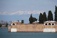
Along with neighbouring San Cristoforo della Pace, the island was a popular place for local travellers and fishermen to land.
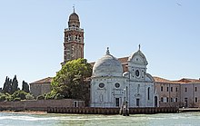
Chiesa di San Michele in Isola of 1469, the first Renaissance
church in Venice, and a monastery lie on the island, which also served for a time as a prison.
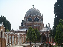
San Michele cemetery
The island has served as the principal cemetery of Venice since 1807.
Gallery
-
 Church S.Michele in Isola
 -
 Walls of San Michele
 -
 Chapel of San Rocco
 -
 San Cristoforo
 -
 Graves


See also
References
External links
Wikimedia Commons has media related to San Michele (Venice).