
Isthmus of Corinth
Isthmus of Corinth | |
|---|---|
 Aerial photograph of the isthmus of Corinth | |
 Isthmus of Corinth | |
| Coordinates: 37°56′29″N 22°59′16″E / 37.94139°N 22.98778°E | |
| Offshore water bodies | Gulf of Corinth and Saronic Gulf |
| Dimensions | |
| • Width | 6.3 km |

The Isthmus of Corinth (
To the west of the Isthmus is the Gulf of Corinth, and to the east the Saronic Gulf. Since 1893 the Corinth Canal has run through the 6.3 km (3.9 mi) wide isthmus, effectively making the Peloponnese an island. Today, two road bridges, two railway bridges and two submersible bridges at both ends of the canal connect the mainland side of the isthmus with the Peloponnese side. Also a military emergency bridge is located at the west end of the canal.

History of the canal
The idea for a shortcut to save boats from having to sail all the way around the Peloponnese was long considered by the Ancient Greeks. The first attempt to build a canal there was carried out by the tyrant Periander in the 7th century BC. He abandoned the project owing to technical difficulties, and instead constructed a simpler and less costly overland stone ramp, named Diolkos, as a portage road. Remnants of Diolkos still exist today next to the modern canal. When the
abandoned the project as being too expensive.In the modern era, the idea was first seriously proposed in 1830, soon after Greece's independence from the Ottoman Empire, and was brought to completion in 1893 after eleven years' work.
Preservation efforts
Near the canal runs an ancient stone trackway, the Diolkos, once used for dragging ships overland. There are major concerns about preservation of this path. Greek campaigners are calling for greater effort by the Greek government to protect this archaeological site.[5]
Hexamilion wall
The Hexamilion wall is a Roman defensive wall constructed across the Isthmus of Corinth guarding the only land route into the Peloponnese peninsula from mainland Greece. It is located close to the Corinth Canal, and is the largest single archaeological structure in Greece.
-
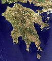 The Peloponnese seen from space, with the Isthmus of Corinth at upper right
 -
 Isthmus of Corinth
 -
 Old map of Corinth Canal area


References
- ^ Strabo, Geography. 9.1.6 Archived 2013-12-13 at the Wayback Machine.
- ^ Plutarch, Parallel Lives , Theseus Plut. Thes. 25
- ^ Flavius Josephus, The Wars of the Jews, Book 3 Chapter 10 paragraph 10
- ^ Pliny the Elder, The Natural History Plin. Nat. 4.5
- ^ BBC report
| International | |
|---|---|
| National | |
| Geographic | |