
Jaša Tomić, Sečanj
This article needs additional citations for verification. (December 2017) |
Jaša Tomić
| |
|---|---|
| Postal code | 23230 |
| Area code | +381(0)23 |
| Car plates | ZR |
Jaša Tomić (
Serbian Cyrillic: Јаша Томић) is a town located in the municipality of Sečanj, in the Central Banat District of Serbia. It is situated in the Autonomous Province of Vojvodina. The town has a Serb
ethnic majority and a population numbering 2,982 people (2002 census).
Name
The town is named after
Serbian Latin Jaša Tomić, in Croatian as Modoš, in German as Modosch, in Hungarian as Módos, in Romanian as Modoș, and in Banat Bulgarian as Modoš. The former name for the town used in Serbian was Modoš (Модош) as well. It is assumed that the old village name, Modoš, derived from the Latin phrase modus transciendi, which in English means way of crossing the river.[1]
History
The oldest known settlements in this area date from the 3rd and 2nd millennia BC. Findings from the
Topographic names of Slavic origin found in the area, such as the Grešara, Mlaka, Margitica, Kamenica, Livade, Selište, Rasove, Vagan, Bavanište, etc., testify that the area was inhabited by Slavs from the 5th century onwards.[3][1]
Historically, the first written mention was in 1334 as Madus. At that time the village was administered by the
Kiev.[1]
In 1552, Modoš became part of the
Patriarchal Monastery of Peć recorded the names of Serb inhabitants of Modoš - priest Jaftimije and priest Zaharije, Ilija, Granny Romana, Milić Radojević, Vladislav, Rusmir, Vuja, Komlenija, Avram, Gavril Panov, Mata, Radomir, Cveja Vranešev, Andreja, and Petar.[1]
In 1717, Modoš became part of the
Catholic
church was built.
In 1836, the population of Modoš numbered 3560, of whom 2440 were
Voivodeship of Serbia and Temes Banat, a separate Habsburg crown land. After abolition of the Voivodeship in 1860, Modoš was again included in Torontal County
.

During the 1860s, the ethnic structure changed as some
Serb
communities.
In November 1918, the army of the
Banat, which formally was part of Serbia
.
In 1944, Jaša Tomić became part of the
People's Republic of Serbia within Yugoslavia. The German population had mostly fled from Jaša Tomić by the end of the war (in 1944), while some mainly Serb colonists from Bosnia and Herzegovina, Central Serbia and Croatia settled in the town from 1945. Post-war population censuses recorded a Serb ethnic majority in the town. Until the 1950s, Jaša Tomić was the seat of the municipality, but in 1955 this municipality was abolished and the town became part of the municipality of Zrenjanin. Later a separate municipality of Sečanj
was formed and town of Jaša Tomić was included into this municipality. However, even today Jaša Tomić is the largest settlement in the Sečanj municipality and the only settlement in the municipality with town status, Sečanj, its seat, being only a village. In 2005, the town was devastated by floods.
Demographics
| Year | Pop. | ±% |
|---|---|---|
| 1869 | 4,272 | — |
| 1900 | 4,614 | +8.0% |
| 1921 | 4,750 | +2.9% |
| 1948 | 4,378 | −7.8% |
| 1953 | 4,569 | +4.4% |
| 1961 | 4,420 | −3.3% |
| 1971 | 3,831 | −13.3% |
| 1981 | 3,625 | −5.4% |
| 1991 | 3,544 | −2.2% |
| 2002 | 3,131 | −11.7% |
| 2011 | 2,382 | −23.9% |
Ethnic groups (2002 census)
- Serbs = 2,126 (71.29%)
- Hungarians = 251 (8.42%)
- Romani = 142 (4.76%)
- Yugoslavs = 125 (4.19%)
- Bulgarians = 29 (0.97%)
- Macedonians = 11 (0.37%)
- Croats = 10 (0.34%)
- others.
Notable citizens
- Stevan Aleksić, a famous Serbian painter, lived and worked.
- Marta Savić, singer
See also
- List of places in Serbia
- List of cities, towns and villages in Vojvodina
References
- ^ a b c d e f g h "MONOGRAFIJA MODOŠKE PAROHIJE - NMR Info". Archived from the original on 2010-11-09.
- ^ "HISTORICAL PICTURE OF DEVELOPMENT OF EARLY IRON AGE IN THE SERBIAN DANUBE BASIN" (PDF). Balkaninstitut.com. Retrieved 28 December 2017.
- ^ a b [1] [permanent dead link]
Literature
- Jovan Erdeljanović, Srbi u Banatu, Novi Sad, 1992.
- Slobodan Ćurčić, Broj stanovnika Vojvodine, Novi Sad, 1996.
- Dr Dušan J. Popović, Srbi u Vojvodini, knjiga I, Novi Sad, 1990.
Gallery
-
 Flood in Jaša Tomić in 2005
 -
 The Orthodox church
 -
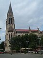 The Ascension of the Blessed Virgin Mary Catholic church


External links
Wikimedia Commons has media related to Jaša Tomić.
- Official site
- "Tamiš reached its maximum" (in Serbian)- B92, April 29, 2005
- Flood in Vojvodina worsens - Wikinews, April 30, 2005
| Authority control databases: National |
|---|