
Jebel Akhdar (Libya)


The Jebel Akhdar (
Geography
The Jebel Akhdar consists of a mountainous
The region is one of the very few forested areas of Libya, which taken as a whole is one of the
Flora

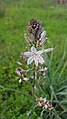
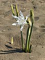
In marked contrast to the aridity prevailing in most of Libya, there are forested areas in this region totalling around 3200 km2, although approximately a third of the original forest has already been destroyed to make way for agriculture. In addition to the forests there are also large areas of maquis and steppe-like vegetation. Typical maquis species are the Phoenician juniper (Juniperus phoenicea), the mastic tree (Pistacia lentiscus), the Kermes oak (Quercus coccifera) and the carob tree (Ceratonia siliqua). In the drier steppe-like areas, branched asphodel (Asphodelus ramosus), prickly burnet (Sarcopoterium spinosum) and white wormwood (Artemisia herba-alba) predominate.[6] More than half of the endemic plant species in Libya are to be found in the Jebel Akhdar and, of these, seven are found only in the region: Arbutus pavarii, Arum cyrenaicum, Bellis sylvestris var. cyrenaica, Cyclamen rohlfsianum, Cynara cyrenaica, Onopordum cyrenaicum and Romulea cyrenaica. [7]
History
Ancient

Documents created during the New Kingdom of Egypt record that to the west there were large populations of metal workers who lived in towns and had plentiful livestock. The only plausible location for these "Libyans" is the Jebel Akhdar.[8]
The ancient
Italian occupation
During the Italian occupation these mountains were identified as a promising area for agriculture and many Italians moved here in the 1930s. This settlement was interrupted during World War II and the villages and farms were deserted and were later reoccupied by Libyans. The mountain chain was the site of major battles between the British Commonwealth and the Axis forces during World War II.[3]
Liberation
The Libyan leader Omar al-Mukhtar used this heavily forested mountainous region to resist the Italian colonization of Libya for more than twenty years.[10]
Galleries
Landscapes
-
 Area near the centre of Jebel Akhdar, (The outskirts of the city of Bayda).
 -
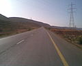 Eastern end of Jebel Akhdar, (near Derna).
 -
 Marj escarpment area.
 -
 Al Bakour escarpment area.
 -
 Al Bakour at the western end of Jebel Akhdar, nearTaucheira).
 -
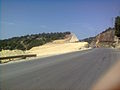 An example of the severe soil erosion which can result from deforestation in the Jebel Akhdar (near Wadi el Kuf Bridge).


Flora
-

-

-

-
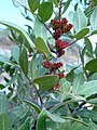
 Ceratonia siliqua (Fabaceae)
 -
 Retama raetam (Fabaceae)
 -
-

-

-

-
-
 Cichorium spinosum (Asteraceae)
 -
-
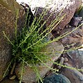
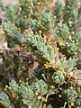
 Sarcopoterium spinosum (Rosaceae)
 -
-
-

-
 Myrsinaceae). Endemic species
 -
-

.jpg)


.jpg)


Fauna
-
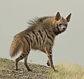 Striped hyena (Hyaena hyaena)
 -
 Red fox (Vulpes vulpes)
 -
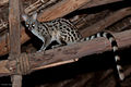 Common genet (Genetta genetta)
 -
 Egyptian mongoose (Herpestes ichneumon)
 -
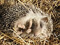 North African hedgehog (Atelerix algirus)
 -
 North African elephant shrew (Petrosaltator rozeti)
_-_cropped.jpg)
.jpg)


See also
- Mediterranean dry woodlands and steppe – lower elevations
- Mediterranean woodlands and forests – higher elevations
References
- ^ Carter, Theresa Howard (1963). "Reconnaissance in Cyrenaica" (PDF). Expedition. 5 (3). University of Pennsylvania Museum of Archaeology and Anthropology: 18–27, page 18.
- ^ S2CID 129730283.
- ^ a b c "Akhdar Mountains". Encyclopædia Britannica. Retrieved 27 November 2016.
- ^ a b "Cyrenaica at 1300m". Hidden Journeys. Retrieved 27 November 2016.
- ISBN 978-0-906559-10-9.
- ^ El-Darier, S.M., El-Mogaspi, F.M. "Ethnobotany and Relative Importance of Some Endemic Plant Species at El-Jabal El-Akhdar Region (Libya)" World Journal of Agricultural Sciences Band 5, Nr. 3, 2009
- ISBN 978-0191626159.
- ^ "Cyrenaica". Livius. Retrieved 27 November 2016.
- ^ "A symbol of resistance: Omar Mukhtar". Worldbulletin News. Retrieved 27 November 2016.
| |
32°35′52″N 21°28′22″E / 32.597734°N 21.472778°E
| International | |
|---|---|
| National | |