
Judaean Mountains
| Judaean Mountains | |
|---|---|
| Harei Yehuda / Jibal Al Khalil | |
 View of the Judaean Mountains near Jerusalem | |
| Highest point | |
| Peak | Mount Halhul |
| Elevation | 1,026 m (3,366 ft)[1] |
| Coordinates | 31°40′N 35°10′E / 31.667°N 35.167°E[2] |
| Geography | |
 Location | |
Road of the Patriarchs (the ridge route) | |
The Judaean Mountains, or Judaean Hills (
The Judaean Mountains formed the heartland of the Kingdom of Judah (930-586 BCE), where the earliest Jewish settlements emerged, and from which Jews are generally descended.[3][4][5]
Geography
The Judaean mountains are part of a more extended range that runs in a north-south direction. The ridge consists of the
The Judaean Mountains were heavily forested in antiquity. The range is mostly composed of
Geology and palaeontology
The Judaean Mountains are the surface expression of a series of monoclinic folds which trend north-northwest through Israel. The folding is the central expression of the Syrian Arc belt of anticlinal folding that began in the Late Cretaceous Period in northeast Africa and southwest Asia. The Syrian Arc extends east-northeast across the Sinai, turns north-northeast through Israel and continues the east-northeast trend into Syria. The Israeli segment parallels the Dead Sea Transform which lies just to the east.[10][11] The uplift events that created the mountain occurred in two phases one in the Late Eocene-Early Oligocene and second in the Early Miocene.[12]
In
The range has
, where fossils of prehistoric flora and fauna were found.In the Hebrew Bible
According to the Hebrew Bible, the Judean mountains were the allotment of the Tribe of Judah and the heartland of the former Kingdom of Judah.[14][15]
Transportation
The main freeway between
An
Winemaking
The Judean Mountains have been associated with
Gallery
-
 The Judaean Mountains between Jerusalem and Ma'ale Adumim
 -
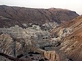 The Judean Hills viewed from the Dead Sea
 -
 View from hilltop overlooking Wadi es-Ṣur, an extension of theElah Valleyin Israel
 -
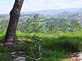
 View from Beit Meir in the Judaean Mountains
 -
 Idyllic scene in the Judean mountains, overlooking the village ofKhirbet ed-Deir which sits along the Green Line
 -
 The ruined structure of an ancient house, near Neve Michael
 -
 Remains of Sataf village


See also
- Judaean Desert, the arid area in the eastern Judaean Mountains and western Jordan Rift Valley
- Mount of Temptation (Jebel Quruntul)
References
- ^ ISBN 9780306462627. Retrieved 2012-02-13.
- ^ Judaean_Mountains - Mapcarta
- OCLC 463855870.
- )
- OCLC 894671497.
- ^ Palestine: Land, Encyclopaedia Britannica
- )
- ^ Jerusalem Hills - Mapcarta
- ^ Arieh Singer (2007). The Soils of Israel. Springer. pp. 129, 143.
- ^ Abd El-Motaal, Essam; Kusky, Timothy M. (2003). Tectonic Evolution of the Intraplate S-Shaped Syrian Arc Fold-Thrust Belt of the Middle East Region in the Context of Plate Tectonics (PDF). Archived from the original (PDF) on 2016-03-03. Retrieved 2012-02-23.
{{cite book}}:|work=ignored (help) - .
- .
- ^ "History of Jerusalem from Its Beginning to David". Biu.ac.il. 1997-03-06. Retrieved 2012-02-13.
- ^ "Cambridge History of Judaism". Cambridge.org. p. 210. Retrieved 16 August 2011. "In both the Idumaean and the Ituraean alliances, and in the annexation of Samaria, the Judaeans had taken the leading role. They retained it. The whole political–military–religious league that now united the hill country of Palestine from Dan to Beersheba, whatever it called itself, was directed by, and soon came to be called by others, 'the Ioudaioi'"
- ^ A History of the Jewish People, edited by Haim Hillel Ben-Sasson, page 226, "The name Judea no longer referred only to...."
- ^ a b Todd, Cathrine (2019-04-17). "The Raw Beauty Of The Wines From The Judean Hills". Forbes. Retrieved 2023-09-02.
- PMID 28614416.
- ISSN 2572-2611.
External links
 Media related to Judaean Mountains at Wikimedia Commons
- Pictures
- Judaean Mountains & Jerusalem
- Symbolism and Landscape: The Etzion Bloc in the Judaean Mountains, Yossi Katz and John C. Lehr
| International | |
|---|---|
| National | |