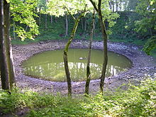
Kaali crater
| Kaali crater | |
|---|---|
| Impact crater/structure | |
| Confidence | Confirmed |
| Diameter | 110 m (360 ft) |
| Age | 3237+/-10 14C yr BP |
| Location | |
| Coordinates | 58°22′22″N 22°40′10″E / 58.37278°N 22.66944°E |
| Country | Estonia |


Kaali is a group of nine meteorite craters in the village of Kaali on the Estonian island of Saaremaa.[1] Most recent estimates put its formation shortly after 1530–1450 BC (3237+/-10 14C yr BP).[2] It was created by an impact event and is one of the few impact events that has occurred in a populated area (other ones are: Henbury craters and Carancas crater).
Before the 1930s there were several hypotheses about the origin of the crater, including theories involving vulcanism and karst processes. Its meteoritic origins were first conclusively demonstrated by Ivan Reinvald[3] in 1928, 1933 and 1937.
Formation
The impact is thought to have happened in the
At an altitude of five to ten km (20,000 to 30,000 ft), the meteor broke into pieces and fell to the Earth in fragments, the greatest of which produced a crater with a diameter of 110 m (360 ft) and a depth of 22 m (72 ft). The explosion removed approximately 81,000 m3 (2,900,000 cu ft) of dolomite and other rocks and formed a 7 to 8 km (20,000 to 30,000 ft) tall, extremely hot gas flow. Vegetation was incinerated up to 6 km (3.7 mi) from the impact site.[7]
Kaali Lake (Estonian: Kaali järv) is on the bottom of this crater. Eight smaller craters are also associated with this bombardment. Their diameters range from 12 to 40 m (39 to 131 ft) and their respective depths vary from one to four metres (3.3 to 13.1 ft). They are all within one kilometre (0.62 mi) of the main crater.
Effects
According to the theory of more recent impact, Estonia at the time of impact was in the
In mythology
Scholars, such as Karl Kello,
According to a theory first proposed by

Namesake
The asteroid
Meteoritic iron artefacts
In 2023, archaeologists analyzed an arrowhead from Switzerland made of meteoritic iron whose composition suggested its origin from the Kaali meteorite.[11]
References
- ^ "Kaalijärv". Earth Impact Database. Planetary and Space Science Centre University of New Brunswick Fredericton. Retrieved 2008-12-30.
- ISSN 1945-5100.
- ^ "Reinwald, Ivan - Eesti Entsüklopeedia".
- ^ Bianca Mikovitš. Teadlaste töö tulemus Kaali kraatri vanuse määramisel ühtib vana regilauluga Maaleht, January 26, 2016
- ^ Raukas, A.; et al. (1995). "On the age of the meteorite craters at Kaali (Saaremaa Island, Estonia)". Proceedings of Estonian Academy of Sciences, Geology 44:177–183.
- ISSN 1945-5100.
- ^ a b "Kaali Crater". Wondermondo. 2012-11-22.
- .
- OCLC 162329217.
- ^ a b Lennart Meri (1976). Hõbevalge (Silverwhite). Tallinn, Estonia: Eesti Raamat.
- .
- Tiirmaa, R. (1992). "Kaali Craters of Estonia and Their Meteoritic Material". Meteoritics. 27 (3): 297. Bibcode:1992Metic..27Q.297T.
- Anto Raukas; J.-M. Punning; T. Moora; Ü. Kestlane; A. Kraut (2005). The Structure and Age of the Kaali Main Crater, Island of Saaremaa, Estonia. pp. 341–355. )


