
Kabini River
This article includes a list of general references, but it lacks sufficient corresponding inline citations. (December 2019) |
| Kapila | |
|---|---|
 Kapila River from Kabinigiri, Kerala | |
| Location | |
| Country | India |
| State | Kerala, Karnataka |
| Physical characteristics | |
| Source | Panamaram |
| • location | Wayanad district, Kerala, India |
| • coordinates | 11°48′01″N 76°04′29″E / 11.80028°N 76.07472°E |
Tirumakudal Narsipur | |
• location | Mysore district, Karnataka, India |
• coordinates | 12°12′56″N 76°54′40″E / 12.21556°N 76.91111°E |
The Kabini River is one of the major tributaries of the river
Close to the town of Sargur it forms the huge Kabini Reservoir. The backwaters of the Kabini reservoir are very rich in wildlife especially in summer when the water level recedes to form rich grassy meadows. The Kabini dam is 2,284 ft (696 m) in length with an original gross storage of 19.52 tmcft. The Kabini Dam is situated between villages Bichanahalli and Bidarahalli having distance of 17 km (11 mi) 6 km away from Sargur town in Heggadadevana kote taluk, Mysore district, Karnataka. [2]
Wildlife
The Kabini Forest Reserve is one of the most popular
Course

The river originates in the Pakramthalam hills at
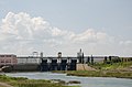
Kabini dam
| Kabini dam | |
|---|---|
 | |
| Coordinates | 11°58′25″N 76°21′10″E / 11.9735°N 76.3528°E |
| Dam and spillways | |
| Type of dam | Earthen Dam with Left Bank spillway |
| Impounds | Kapila River |
| Height | 166 ft. above River Bed Level |
| Length | 12,927 ft. |
The
The dam is spread over an area of 55 hectares covering forests, rivers, lakes and valleys. This dam also provides water to the combined system of Sagaredoddakere and Upper Nugu Dams. There is an arrangement of lifting and transfer of 28.00 TMC of water during the monsoons months from the kabini dam to the other two smaller dams. [7]
Kabini Bridge
The
Image gallery
-
 Indian coraclesare used on the Kabini river
 -
 Kabini reservoir
 -
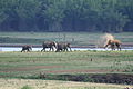 Elephant family on the Kabini river bank
 -
 The river Kabini in Nanjangud


References
- ^ "Kabini or Kapila River". District Administration Mysuru, GOI. Retrieved 2 March 2024.
- ^ "Kabini or Kapila River". District Administration Mysuru, GOI. Retrieved 2 March 2024.
- ^ "KABINI WILDLIFE RESERVE AND KABINI RIVER". Kabini Wildlife. Retrieved 2 March 2024.
- ^ "Nagarahole Tiger Reserve". Karnataka Forest Department. Retrieved 2 March 2024.
- ISBN 9798887498225. Retrieved 2 March 2024.
- ^ "Water released from Kabini reservoir reaches Mettur dam". The Hindu. 17 June 2018. Retrieved 2 March 2024.
- ^ Kandya, Ranjith (17 December 2018). "80,000 cusecs out from Kabini reservoir, highest ever". Deccan Herald. Retrieved 2 March 2024.
- ^ "285-year-old Kabini rail-cum-road bridge near Nanjangud to get facelift". Deccan Herald. 5 October 2020. Retrieved 2 March 2024.